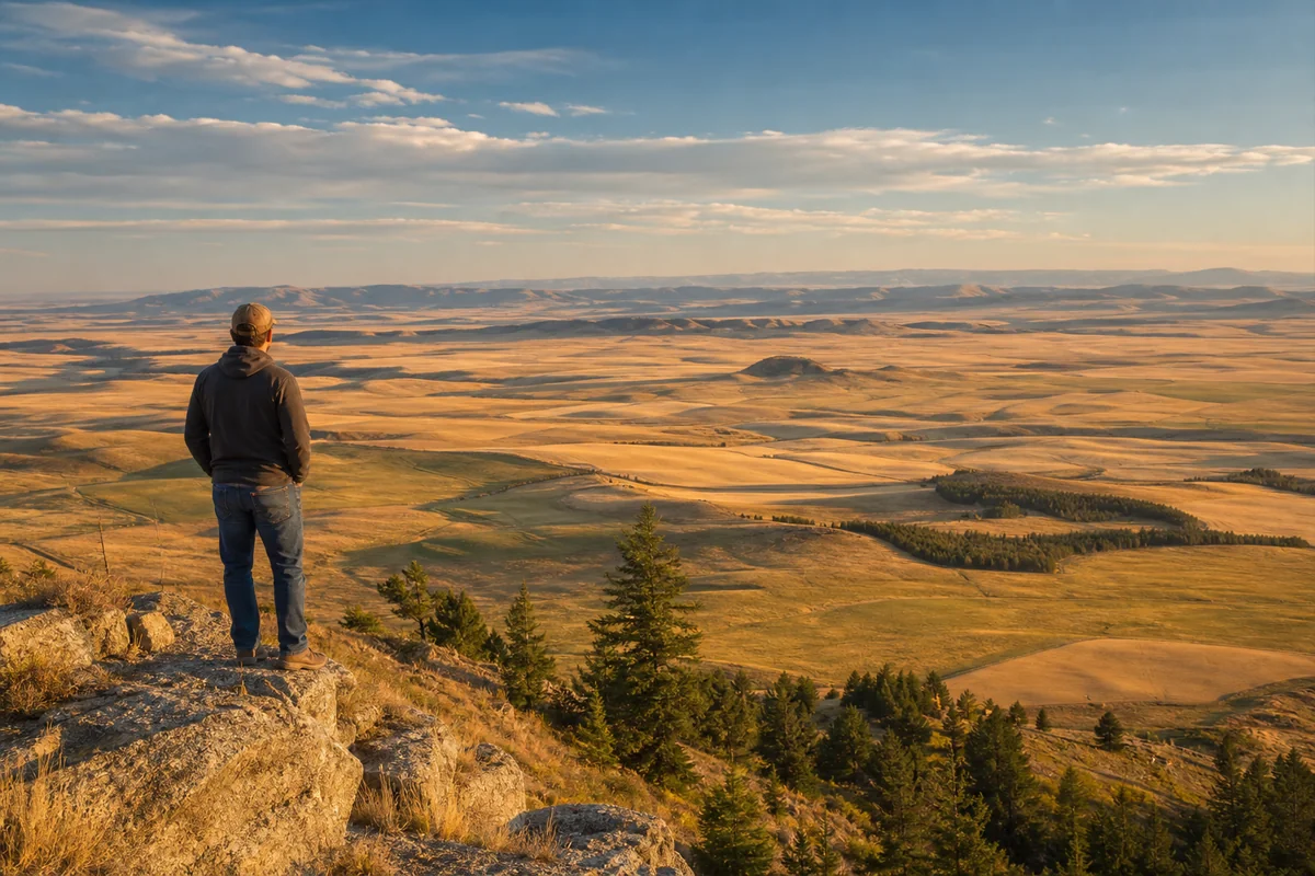
Standing on the windswept plains outside Ekalaka last September, I watched a dust devil spin across cracked earth under a blazing sun and genuinely wondered whether I’d somehow drifted into Nevada. That feeling — Montana doesn’t look the way most visitors expect it to — sits at the heart of the question every traveler eventually asks: is Montana actually a high desert?
The short answer is no — but the longer answer is much more interesting, and it explains why eastern Montana can feel so completely different from the alpine Montana you see in the brochures.
- No, Montana is not classified as a high desert anywhere on its 147,000+ square miles. No part of the state meets the precipitation thresholds for true desert climate (Köppen BW).
- But large parts of Montana are classified as cold semi-arid steppe (Köppen BSk) — particularly the central and eastern plains. This is the climate category that makes places like Glendive, Miles City, and the Pryor Mountains feel desert-adjacent.
- Western Montana’s mountains are humid continental (Köppen Dfb/Dfa) — closer to the Rockies-and-forest stereotype than to anything desert.
- The closest things Montana has to genuine high-desert character: Centennial Valley, Pryor Mountains, Big Hole Valley, and the Bighorn Canyon region — all sagebrush steppe with desert-adjacent vegetation.
- For trip planning: eastern Montana from May through September genuinely does demand desert-style preparation, even if the climate-science label says otherwise.
The Climate-Science Answer: What Köppen Actually Says About Montana
The most authoritative way to settle the “is Montana a high desert” question is the Köppen climate classification system, the standard reference for global climate types. Here’s where Montana actually sits:
| Climate Type (Köppen) | Description | Where It Applies in Montana |
|---|---|---|
| BSk (cold semi-arid steppe) | Annual precipitation 8–16 in; mean annual temp below 18°C; evaporation usually exceeds precipitation | Most of eastern and central Montana, broad lowlands east of the Continental Divide |
| Dfb (humid continental, warm summer) | Cold winters, warm summers, year-round precipitation | Western Montana mountain valleys, Helena, Butte, Bozeman elevation zones |
| Dfa (humid continental, hot summer) | Cold winters, hot summers, year-round precipitation | Lower-elevation eastern Montana cities like Great Falls and Miles City |
| ET (polar tundra) | Average warmest-month temperature below 50°F | High elevations near Granite Peak, alpine Glacier National Park |
| BWk (cold desert) | Annual precipitation under 50% of the threshold for semi-arid; cold | Not applied to any part of Montana |
| BWh (hot desert) | Hot, very arid | Not applied to any part of Montana |
The key takeaway: Montana has zero BW (true desert) territory. The driest places in the state — even the badlands of the Missouri Breaks and southeast Montana — fall into the BSk semi-arid steppe category, which by definition receives more precipitation than a desert.
For broader regional context, see our where is Montana located hub and the related Montana biomes and Montana elevation guide.
What “High Desert” Actually Means
Casual usage tosses “high desert” around for any dry, elevated landscape — but the term has a specific meaning that’s worth knowing before judging whether Montana qualifies.
True high desert = a region with:
- Arid climate (annual precipitation typically under 10 inches),
- Elevated terrain (typically above 2,000 feet, often above 4,000 feet),
- Distinctive desert plant communities (big sagebrush, juniper, drought-adapted shrubs and cacti),
- Cold-winter regime that distinguishes it from hot deserts.
The classic North American high desert is the Great Basin, spanning Nevada, parts of Utah, southeast Oregon, and small portions of Idaho. The Great Basin sits mostly between 4,000 and 6,000 feet, receives 5–9 inches of annual precipitation, and supports sagebrush-juniper plant communities adapted to deep aridity. That’s the reference point most Americans have in mind when they hear “high desert.”
Montana doesn’t meet those criteria — even in its driest places. The eastern plains and breaks receive 10–16 inches of annual precipitation in most years, which is enough to support a prairie grassland ecosystem rather than a desert one. Native grasses dominate; sagebrush exists but doesn’t define the landscape.
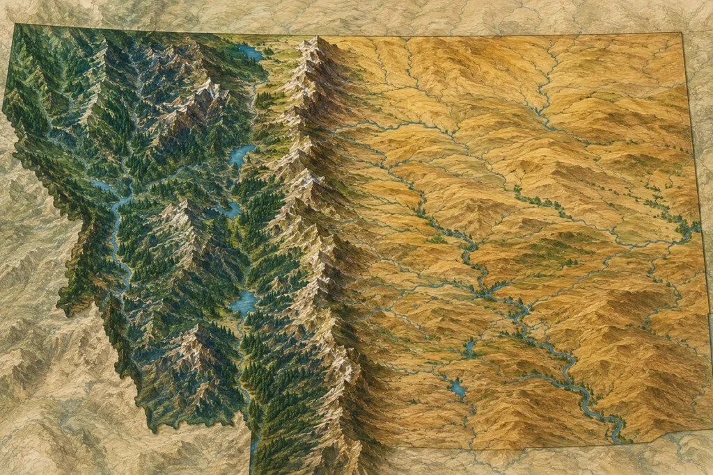
Montana’s Real Climate Reality: Two Worlds Divided by the Continental Divide
After driving more than 15,000 miles across Montana over the past few years, I’ve come to think of the state as essentially two different climates stitched together by mountain passes.
Western Montana — The Wet Side
The mountains and valleys west of the Continental Divide receive significant Pacific moisture. The Kalispell area gets 16–18 inches annually; the higher Bitterroot and Cabinet Mountains can exceed 60 inches. The Kootenai National Forest area near Yaak gets over 70 inches in places — closer to a rainforest than a desert.
Forest cover is dense: western red cedar, western hemlock, larch, ponderosa pine. Rivers run year-round at strong flows. Snowpack accumulates dramatically in winter. Western Montana, climatologically speaking, has more in common with northern Idaho and inland Washington than with the dry American West.
Eastern Montana — The Dry Side
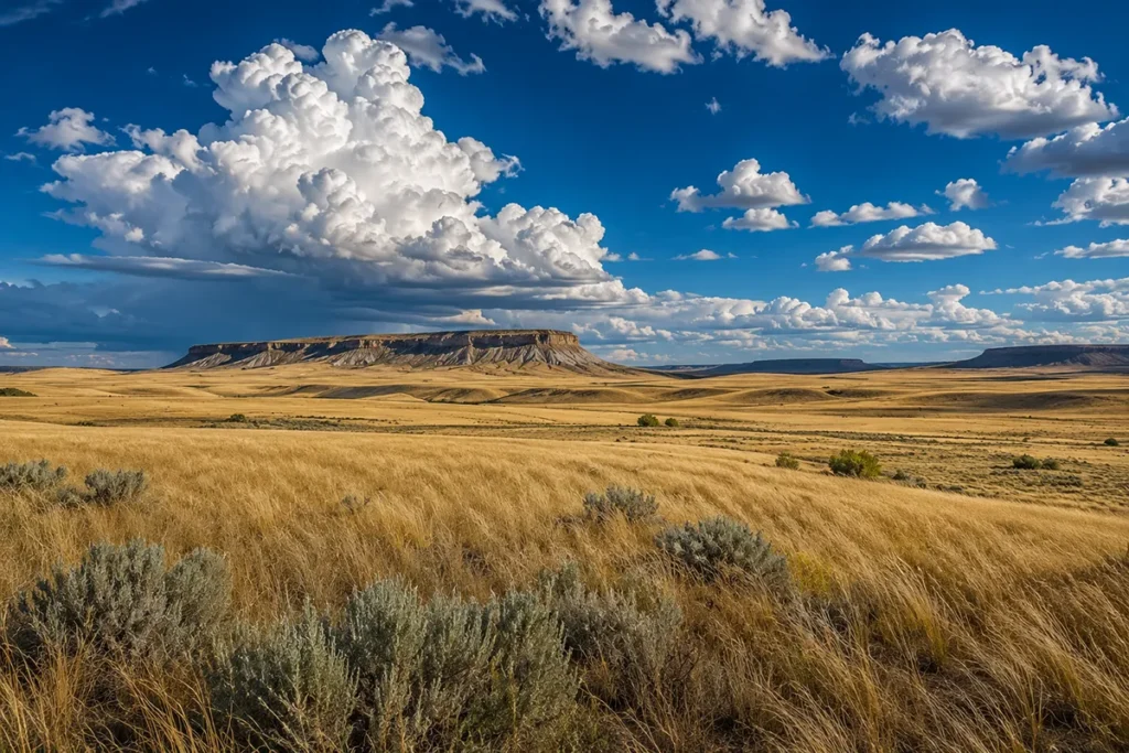
Cross the Continental Divide and the climate transforms. The Rocky Mountains create a rain shadow that strips Pacific moisture before it reaches the plains. By the time you’re in Glendive, Miles City, Sidney, or Jordan, you’re in cold semi-arid steppe (BSk) with annual precipitation of 11–14 inches.
This is the part of Montana that feels desert-adjacent — golden brown grasslands by mid-July, dust devils on hot afternoons, sparse vegetation under enormous skies. It’s not desert, but it shares enough characteristics with one that confused visitors aren’t crazy for asking.
For more on the regional geography that produces this split, see our companion guides: does Montana belong to the Great Plains and is Montana truly in the Midwest.
Annual Precipitation Across Montana: The Numbers
Climate-station data tells the story more clearly than narrative ever can. These figures come from long-term NOAA averages for representative locations:
| Region | Representative Town | Elevation (ft) | Annual Precipitation |
|---|---|---|---|
| Far NW Montana | Yaak / Troy area | 1,800–3,000 | 30–60+ in |
| Flathead Valley | Kalispell | 2,963 | ~17 in |
| Bitterroot Valley | Hamilton | 3,575 | ~13 in |
| Western Mountain | Missoula | 3,209 | ~14 in |
| Central Continental | Helena | 3,875 | ~12 in |
| Central Plains | Lewistown | 3,960 | ~17 in |
| Yellowstone Valley | Billings | 3,126 | ~14 in |
| Hi-Line | Havre | 2,494 | ~12 in |
| Southeast Plains | Miles City | 2,360 | ~14 in |
| Far East Plains | Sidney | 1,920 | ~14 in |
| Northeast | Glasgow | 2,109 | ~12 in |
| Central-East | Jordan | 2,628 | ~13 in |
| Southwest Valley | Dillon | 5,096 | ~11 in |
| Centennial Valley | Lakeview | 6,706 | ~14 in |
For the state’s mildest and driest temperature regimes, see our Montana warmest places guide. For the wider context on the state’s coldness and snowfall, see how cold does it get in Montana and does it snow in Montana.
The Closest Montana Gets to High Desert
Even though no Montana location qualifies as desert in Köppen terms, several pockets come closer than the rest. These are the places where the “is this Nevada?” feeling kicks in hardest.
The Centennial Valley
Tucked along the Idaho border in southwestern Montana, the Centennial Valley sits at ~6,600 feet and receives only 12–14 inches of annual precipitation.
The vegetation is dominated by big sagebrush and bunchgrass — the classic sagebrush-steppe community you’d find in southern Idaho or northern Nevada.
The Red Rock Lakes National Wildlife Refuge here protects one of Montana’s most genuinely high-desert-feeling landscapes, complete with pronghorn, sage grouse, and the kind of wide-open silence usually associated with the Great Basin.
The Pryor Mountains
South of Billings and bordering Wyoming, the Pryor Mountains are one of Montana’s most underrated landscapes — and the part of the state that most closely resembles classic high desert in terms of vegetation.
The lower slopes support sagebrush, Utah juniper, and limber pine. The Pryor Mountains Wild Horse Range adds a desert-adjacent feel that’s almost surreal in a state better known for elk and grizzlies.
The Big Hole and Beaverhead Country
Around Dillon and the Big Hole Valley, the high-elevation grasslands take on a distinctly arid character.
Snowfall is real here, but the summer dryness, sagebrush presence, and Continental Divide rain shadow create the closest thing to genuine high desert in the southwestern corner of the state.
The Madison Valley further east shares some of these characteristics.
The Bighorn Canyon Area
Bighorn Canyon National Recreation Area straddles Montana and Wyoming. The Montana side shows sagebrush slopes, exposed sandstone, and minimal vegetation that genuinely earns comparison to the desert Southwest.
The canyon’s microclimate adds heat-reflecting walls and limited precipitation in a region that already trends dry.
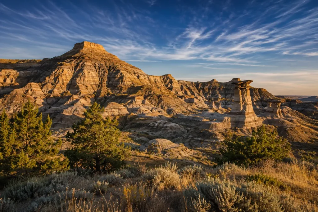
The Missouri River Breaks and Eastern Badlands
The badlands of the Missouri Breaks (particularly the Charles M. Russell National Wildlife Refuge), Makoshika State Park near Glendive, the Terry Badlands, and Medicine Rocks State Park near Ekalaka all produce desert-style landscapes — eroded sandstone, sparse vegetation, dramatic light, summer heat.
These are short-grass prairie technically, but the badlands topography makes them photograph and feel like the desert Southwest.
Why Eastern Montana Feels Desert-Like Even Though It Isn’t
If the climate data says eastern Montana isn’t desert, why does it feel so desert-adjacent? Several reasons work together:
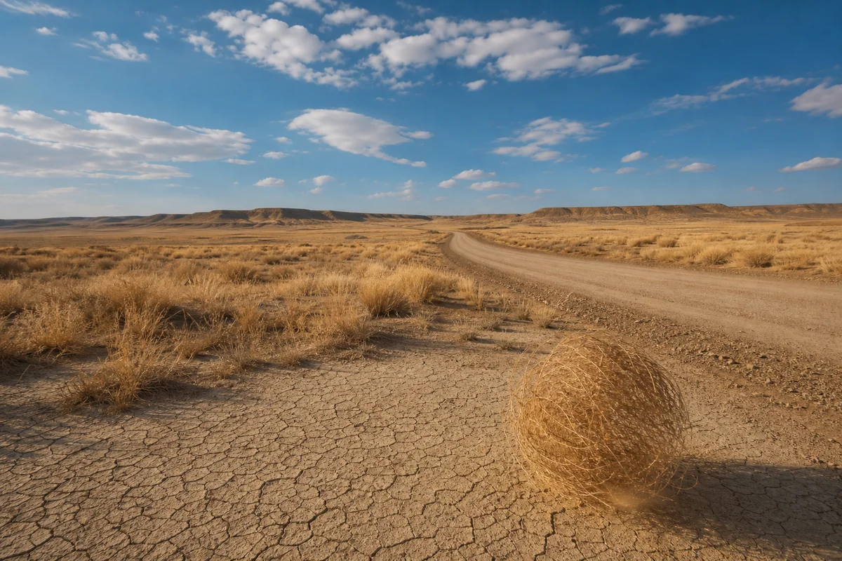
Evaporation outpaces precipitation. BSk steppe climates are defined by potential evapotranspiration that exceeds annual rainfall. What moisture does fall evaporates quickly under wind and sun. A summer puddle in Circle or Jordan can disappear within an hour.
Wind is constant. Montana is one of America’s windiest states (see our how windy is Montana guide), and constant wind amplifies the drying effect of any sunny day.
Precipitation comes in concentrated bursts. Most rain falls during May and June thunderstorms. By July through September, the eastern plains can go weeks without measurable rain. That seasonal aridity is what produces the brown grasses, cracked soil, and parched-landscape feel.
Sparse vegetation. Treeless or near-treeless prairie reads as desert to eyes accustomed to forested landscapes. The grasses are doing fine — they’re adapted to this regime — but the human eye registers “barren” where there isn’t tree cover.
Low humidity. Eastern Montana humidity in summer afternoons can drop into the 20–30% range. The dry air feels desert-like even when air temperatures aren’t extreme. See our is Montana humid guide for the deeper humidity story.
Travel Implications: Pack Like It’s High Desert, Even If It Isn’t
Whether climate science calls it high desert or not is academic. For trip planning, eastern Montana from May through September requires the same preparation as any genuine high-desert destination.
Hydration
The dry air dehydrates you faster than humid climates do. I drink twice as much water during summer eastern Montana trips as I do at home. Carry at least a gallon per person per day for active travel. Gas stations and water sources are sparse — fill up whenever you have the chance.
Sun Protection
Even at moderate eastern Montana elevations (2,000–3,500 ft), UV exposure is more intense than at sea level. Wear a wide-brimmed hat, use high-SPF sunscreen, and consider UPF clothing for extended outdoor activity. The wind makes sunburn easy to underestimate.
Vehicle and Distance Planning
The eastern Montana corridors between major towns can run 80–100+ miles with limited services. Always start with a full tank, carry water for multiple people, and have an emergency kit. Cell service is unreliable across much of the central and eastern plains.
Bring Layers Anyway
Despite the heat reputation, Montana can swing 40°F+ between afternoon highs and overnight lows even in summer. A fleece for evenings is worth its weight in your day pack.
For broader trip-planning context, see our Montana trip planning guide and best time to visit Montana hub.
Wildfire Season — A Real Risk Connected to the Aridity
The same factors that make eastern and southwestern Montana feel desert-like also drive significant wildfire risk from late June through September. Dry grass fuels, lightning storms, and high winds combine to produce fast-moving prairie and forest fires.
Smoke can settle into eastern Montana valleys for weeks at a time during heavy fire summers, dramatically reducing air quality and visibility. Check current fire conditions before any outdoor trip. See our Montana wildfires overview for full context.
What Travelers Most Often Get Wrong About Montana’s Climate
A few myths I’ve heard repeatedly during my travels:
“Montana is too cold to feel like a desert.” True for the year as a whole, but eastern Montana afternoons in July and August can crack 100°F. The summer arid feel is genuine — see Montana warmest places.
“It’s all forest like Glacier.” Only the far northwest and the mountain valleys. The eastern two-thirds of the state is open grassland, badlands, and breaks.
“The whole state gets the same precipitation.” Glaringly wrong. Annual precipitation ranges from ~10 inches in the far east to 70+ inches in the wettest western mountain pockets — a factor of seven difference within a single state.
“It’s high desert because the elevation is high.” Elevation matters less than aridity and temperature regime for the high-desert label. Montana has elevation; it doesn’t have the precipitation deficit.
Wildlife Adapted to Montana’s Dry Country
If you head into the closest-to-desert pockets of Montana, the wildlife reflects the semi-arid environment:
Pronghorn antelope — the iconic species of Montana’s dry plains. Adapted to wide-open spaces and capable of extraordinary speed; populations are strongest in the southeastern badlands and the Centennial Valley.
Mule deer — far more common than white-tailed deer in the dry country.
Sage grouse — one of the West’s most charismatic prairie birds, dependent on sagebrush ecosystems. Sage-grouse leks in the Centennial Valley and Big Hole are spring spectacles for serious birders.
Prairie rattlesnakes — yes, Montana has rattlers, particularly in the badlands and breaks. Watch your step in tall grass and around rock outcrops during warm months.
Pryor Mountain wild horses — one of the few remaining free-roaming mustang herds in the American West.
Golden eagles — heavily represented in dry-country Montana, along with prairie falcons and ferruginous hawks. Birders flock to the Pryors and the Centennial for raptor-watching.
Broader Context on What Montana Actually Is
The “is Montana a high desert” question connects to several other identity questions about the state. None of them have simple one-word answers:
- Is Montana truly in the Midwest? — Geographically marginal; culturally complicated.
- Is Montana a landlocked state? — Yes, with surprising amounts of water nonetheless.
- Is Montana located on the Canadian border? — Yes, ~545 miles of it.
- Does Montana belong to the Great Plains? — Eastern two-thirds, yes.
- Is Montana considered rural? — Among the most rural states by population density.
Each of these questions exposes the same truth: Montana resists single-word classification. It’s a complicated state stitched together by mountain passes and shaped by extreme geographic diversity. The “is it a high desert” question is just one window into that complexity.
For more of the state’s surprising character, see our list of things Montana is known for and beautiful places in Montana.
A Final Honest Assessment
So — is Montana a high desert? No. Not in any technically defensible sense. The climate-science answer is clear: no part of Montana meets the criteria for true desert (BW) or for the specific high-desert character that defines places like the Great Basin.
But the emotional answer is more complicated, and any honest travel writer should admit it. Eastern Montana in July, the Pryor Mountains on a hot afternoon, the Centennial Valley sagebrush flats at noon — these places feel desert-adjacent, and they demand the same preparation as a Nevada trip would.
The most useful framing: Montana is semi-arid steppe in much of its eastern and central territory, alpine and humid continental in its western mountains, and absolutely nothing approaches true desert anywhere. Plan for the climate you’ll actually encounter, and you’ll have one of the best Western trips of your life.
For more on the year-round climate landscape, see our Montana weather hub and Montana summer and Montana winter weather breakdowns.
Frequently Asked Questions
Is Montana classified as a high desert?
No. Under the Köppen climate classification system, no part of Montana qualifies as true desert (BW). The driest portions of the state — the central and eastern plains — are classified as cold semi-arid steppe (BSk), which receives more precipitation than a desert. The mountains and far-western valleys are humid continental (Dfb/Dfa), and the highest peaks reach polar tundra (ET).
What is the difference between high desert and semi-arid steppe?
True high desert (typically BWk in Köppen) receives less than about 10 inches of annual precipitation and supports desert-adapted plant communities like sagebrush, juniper, and cacti. Semi-arid steppe (BSk) receives 8–16 inches annually and supports prairie grasslands and limited shrubs. Montana’s driest areas sit at the wetter end of the BSk range, which is why grasses dominate rather than true desert vegetation.
What parts of Montana are most desert-like?
Several pockets come closest: the Centennial Valley (sagebrush steppe in southwestern Montana), the Pryor Mountains (sagebrush-juniper community south of Billings), the Big Hole and Beaverhead Valley (around Dillon), and the Missouri Breaks and southeastern badlands (Makoshika State Park near Glendive, Medicine Rocks State Park near Ekalaka, Terry Badlands). None qualifies as true desert, but each offers genuine high-desert atmosphere.
How much does annual precipitation vary across Montana?
Annual precipitation ranges from roughly 10 inches in the driest eastern plains to 70+ inches in the wettest western mountain pockets (Yaak Valley, parts of the Cabinet and Bitterroot ranges). That’s a factor-of-seven difference within a single state — one of the steepest precipitation gradients of any state in the Lower 48.
Should I pack for desert conditions when visiting eastern Montana in summer?
Yes — even though it’s not technically desert. From May through September, eastern Montana demands desert-style preparation: serious sun protection, high water carry, light breathable clothing, and a vehicle emergency kit. Layers for cold nights are essential; temperature swings of 40°F+ between day and night are common.
Does Montana have sagebrush and juniper like classic high desert?
Yes, but unevenly. The southwestern corner (Big Hole, Centennial Valley, Beaverhead County), the Pryor Mountains, and the Bighorn Canyon area all support recognizable sagebrush steppe communities. Utah juniper appears in the Pryors specifically. The eastern grasslands have less sagebrush than these high-elevation pockets — they’re dominated by native bunchgrasses rather than shrubs.
Why does Montana feel so different from one side to the other?
The Continental Divide acts as a climate boundary. Pacific moisture moves east across the western mountains and gets stripped out before reaching the eastern plains. The result is two distinct climate regimes: humid continental forest in the west, cold semi-arid steppe in the east. Visitors who only see one side of the divide often think they understand Montana — but they’ve only seen half of it.
Are there cacti in Montana?
Yes. Plains prickly pear (Opuntia polyacantha) grows widely across eastern Montana grasslands and badlands. Brittle prickly pear (Opuntia fragilis) appears in scattered locations. They’re modest in size compared to Southwest cacti, but they’re a real reminder of how dry parts of the state genuinely are.
What is the driest place in Montana?
The far eastern badlands and the lower Missouri Breaks contend for the title. Stations near the Charles M. Russell National Wildlife Refuge sometimes record annual precipitation under 11 inches. Plevna in southeastern Fallon County (the holder of Montana’s all-time state high temperature record at 117°F) sits in some of the driest country in the state.
Does Montana ever look like Nevada or Utah?
Genuinely, yes — in specific places. Makoshika State Park near Glendive could pass for Utah badlands. The Pryor Mountains would look at home in northwestern Wyoming or the Great Basin. Bighorn Canyon rivals canyon country anywhere in the West. Travelers who only visit Glacier and Yellowstone never see this side of Montana, but it’s just as authentically part of the state as the alpine scenery.
Sources:
- https://en.wikipedia.org/wiki/Regions_of_Montana#:~:text=In%20the%20K%C3%B6ppen%20climate%20classification,as%20Dfb%20(humid%20continental).
- https://earthobservatory.nasa.gov/biome/biodesert.php
- https://pryormountains.org/welcome-to-the-pryors/why-are-the-pryors-special
- https://wrcc.dri.edu/cgi-bin/cliMAIN.pl?mt0617
- https://en.wikipedia.org/wiki/Regions_of_Montana
- https://www.cec.org/north-american-environmental-atlas/climate-zones-of-north-america/
- https://en.wikipedia.org/wiki/Desert_climate
- https://www.britannica.com/science/desert
- https://science.howstuffworks.com/environmental/earth/geology/high-deserts.htm
- https://www.mtpr.org/arts-culture/2018-05-07/field-notes-montanas-rain-shadow-explained
- https://fieldguide.mt.gov/displayES_Detail.aspx?ES=5454
- http://range.altervista.org/Grasslands/Shrub%20Steppe.htm
- https://wrcc.dri.edu/Climate/narrative_mt.php
- https://geology.teacherfriendlyguide.org/index.php/climate-nc/climate-present-nc
- https://fieldguide.mt.gov/displayes_detail.aspx?es=3114
- https://www.ebsco.com/research-starters/environmental-sciences/great-basin-desert
- https://www.weather.gov/media/tfx/wxsummary/montanawx_2021_07.pdf
- https://montanaclimate.org/chapter/water
- https://wrcc.dri.edu/Climate/comp_table_show.php?stype=relhum_pm_means
- https://weather-and-climate.com/average-monthly-Humidity-perc,helena-montana-us,United-States-of-America
- https://pubs.usgs.gov/pp/0272d/report.pdf
- https://apnews.com/article/climate-wildfires-droughts-weather-montana-30cdc426f8ca37c61e5f186a82c6af3e
- https://explorer.natureserve.org/Taxon/ELEMENT_GLOBAL.2.683130/Artemisia_tridentata_ssp_wyomingensis_-_Pseudoroegneria_spicata_Shrub_Grassland
- https://plants.usda.gov/DocumentLibrary/plantguide/pdf/pg_artrw8.pdf
- https://explorer.natureserve.org/Taxon/ELEMENT_GLOBAL.2.722887/Inter-Mountain_Basins_Montane_Sagebrush_Steppe
- http://animalrange.montana.edu/documents/F117.pdf
- https://nvrockart.art/aan_pages/txt/Exploring_Great_Basin_Archaeology.pdf
- https://www.blm.gov/programs/national-conservation-lands/wyoming/pryor-mountain-wsa
- http://montana.plant-life.org/cgi-bin/species03.cgi?Cactaceae_Opuntiapolyacantha
- https://www.fs.usda.gov/wildflowers/plant-of-the-week/opuntia_humifusa.shtml
- https://en.wikipedia.org/wiki/Opuntia_humifusa
- https://edit.jornada.nmsu.edu/catalogs/esd/044A/F044AF001MT
- https://fwp.mt.gov/binaries/content/assets/fwp/conservation/fisheries-management/cutthroat-trout/yellowstone-cutthroat/8–6.6-clarks-fork-of-the-yellowstone-subbasinyctstrategyfinal8_5_13-21.pdf
- https://en.wikipedia.org/wiki/Great_Basin
- https://www.nps.gov/grba/planyourvisit/the-great-basin.htm
- https://archive.legmt.gov/content/Committees/Interim/2017-2018/Water-Policy/Meetings/May-2018/Exhibits/May22/Exhibit8.pdf
- https://fieldguide.mt.gov/displayES_Detail.aspx?ES=9155
- https://www.land.com/property/161.15-acres-in-beaverhead-county-montana/22971688/
- https://hallhall.com/property-for-sale/montana/axes-canyon-hunting-getaway/a09Nu000007Q8Vl/
- https://www.zillow.com/homedetails/Rock-Creek-Rd-Glen-MT-59732/234701156_zpid/
- https://www.nrcs.usda.gov/sites/default/files/2022-09/Montana-TIP-Clarks-Fork-Yellowstone.pdf
- https://explorer.natureserve.org/Taxon/ELEMENT_GLOBAL.2.722894/Inter-Mountain_Basins_Big_Sagebrush_Steppe