The town of Hungry Horse takes its name from two horses who got lost in deep snow during the winter of 1900-01 and survived.
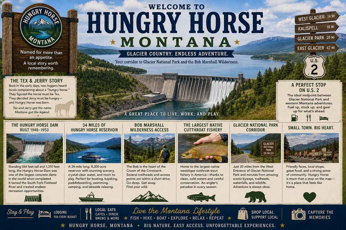
Tex and Jerry — both draft horses pulling a logging sled in the rugged South Fork of the Flathead River country — wandered away from their crew in the middle of one of the most brutal Montana winters on record.
The loggers searched for them, gave up, and assumed the animals had died. A month later, the same crew found Tex and Jerry alive but barely — belly-deep in snow, starving, “skinny as lodgepole pines” according to one account.
Hot mash and careful tending nursed both horses back to health. Jerry went on to pull a fire wagon in Kalispell. Tex did similar duty for the Kalispell Mercantile Company.
The men who had found them called them the “Mighty Hungry Horses,” and the name attached itself to the creek they’d been lost on, then to the mountain above, and eventually to the community that grew up at the South Fork’s confluence with the main Flathead River.
The town today exists primarily because of what happened forty years after Tex and Jerry survived. In April 1948, the U.S. Bureau of Reclamation began construction on what would become the Hungry Horse Dam — a 564-foot-high concrete thick-arch dam across the South Fork of the Flathead.
When completed in July 1953, the dam was the third-largest and second-tallest concrete dam in the world.
It cost approximately $100 million, took five years to build (winter shutdowns each season slowed progress), and created Hungry Horse Reservoir — a 34-mile-long, 23,800-acre lake surrounded by more than 25 mountain peaks of the Flathead and Swan ranges and the Bob Marshall Wilderness.
The dam’s four Francis turbines generate 428 megawatts of hydroelectric power, much of it flowing into the broader Columbia River system that powers the Pacific Northwest.
What makes Hungry Horse genuinely worth slowing down for, beyond the dam itself, is the South Fork Flathead drainage above the reservoir.
The South Fork was designated a Wild and Scenic River in 1976. It originates in the Bob Marshall Wilderness at the confluence of Young’s Creek and Danaher Creek, then flows 60 miles north through some of the most remote roadless country in the contiguous United States before entering Hungry Horse Reservoir.
Because the dam isolated this drainage from the rest of the Flathead system, the South Fork Flathead now supports the largest connected population of migratory, genetically unaltered westslope cutthroat trout left in the United States.
For native-fish anglers, this is one of the most ecologically significant fisheries in North America.
TL;DR
- Hungry Horse (~745) is an unincorporated community in Flathead County on US-2, 15 miles south of the West Glacier entrance to Glacier National Park.
- The town and dam are named for Tex and Jerry — two freight horses who survived being lost in deep snow for a month during the winter of 1900-01.
- Hungry Horse Dam (564 ft, 2,115 ft long, thick-arch concrete) was built 1948-1953 by the Bureau of Reclamation — at construction, the third-largest concrete dam in the world.
- The Visitor Center offers free dam crest tours Memorial Day Weekend through Labor Day.
- Hungry Horse Reservoir is 34 miles long, 23,800 acres, surrounded by 25+ mountain peaks.
- The South Fork Flathead River above the reservoir is Wild and Scenic designated and supports the largest connected population of native westslope cutthroat trout in the United States.
- The community is a gateway to the Bob Marshall Wilderness via the Spotted Bear Ranger District (~55 miles south on gravel road).
- Best for: Glacier National Park corridor lodging alternative, reservoir fishing and boating, Bob Marshall Wilderness access, hydroelectric history, and US-2 travelers between Kalispell and West Glacier.
Liked this article?
Add Roaming Montana as a preferred source so you see more of our articles and guides on Google.
Hungry Horse at a Glance
| Population (2020) | ~745 |
|---|---|
| County | Flathead County |
| Status | Unincorporated community (CDP) |
| Region | Northwest Montana (Flathead Valley / Glacier corridor) |
| Elevation | 3,143 ft |
| Distance to West Glacier | ~15 miles east on US-2 (~20 min) |
| Distance to Columbia Falls | ~9 miles southwest (~12 min) |
| Distance to Kalispell | ~20 miles southwest (~25 min) |
| Distance to Whitefish | ~24 miles west (~30 min) |
| Distance to Glacier Park International Airport (FCA) | ~22 miles west (~25 min) |
| Distance to Spotted Bear Ranger Station (Bob Marshall gateway) | ~55 miles south on gravel |
| Best for | Glacier corridor lodging, dam tours, reservoir recreation, Bob Marshall access, native cutthroat fishing |
What Makes Hungry Horse Different
The geographical position of Hungry Horse is the first thing to understand. The town sits at the point where the South Fork of the Flathead River — the river that drains the Bob Marshall Wilderness — joins the main stem of the Flathead River.
US Highway 2 passes through Hungry Horse on its way between Kalispell to the southwest and West Glacier 15 miles to the east.
The dam, the reservoir, and the entirety of the South Fork Flathead drainage extend south from the town for 60+ miles through some of the most genuinely wild country in the contiguous United States.
This combination — a working town on a busy national-park-corridor highway that also sits at the doorstep of one of America’s largest wilderness areas — is unusual. Most communities are one or the other.
The Hungry Horse Dam construction story deserves understanding. The original Reclamation proposal called for a dam significantly larger than what was built, including an 8-mile tunnel that would have diverted water from the Middle Fork of the Flathead into the reservoir.
That tunnel was never built; the South Fork drainage alone provides the water. Construction took five years (1948-1953) because winter conditions forced annual shutdowns.
Clearing the reservoir basin of timber was a separate $10 million project — 90 million board feet of timber was removed, much of it used for saw-logs, poles, and railroad ties.
The contractor cleared remaining debris by chaining a 4½-ton steel ball to two tractors and dragging it through the deadfall and stumps.
Multiple Forest Service buildings, bridges, and a fire lookout tower were rebuilt elsewhere when the rising reservoir would have inundated them. The dam itself contains approximately 2.9 million cubic yards of concrete and was constructed by a contractor combine known as General Shea Morrison.
The reservoir’s role in the Columbia River system is significant and worth understanding. Hungry Horse Reservoir was specifically designed to store water for downstream power generation at Grand Coulee Dam and Bonneville Dam on the Columbia.
The 3.5 million acre-feet of storage allows water managers to time releases for maximum hydropower output across the entire Columbia system.
The dam also provides flood control — Flathead Valley flood damage exceeded one million dollars in some pre-dam years and has been substantially reduced since 1953.
The native fishery is the contemporary ecological gem. The South Fork Flathead’s 60-mile run through the Bob Marshall Wilderness, isolated above the dam from the rest of the Flathead system, has preserved native westslope cutthroat trout in their original genetic state and migratory life cycle.
Anglers willing to backpack into the wilderness can experience cutthroat fishing in conditions essentially unchanged since pre-European settlement.
Hungry Horse Reservoir itself supports cutthroat, bull trout (federally threatened, catch-and-release only), and mountain whitefish.
For broader trip context, see my Montana cities and towns hub.
The Top 10 Things to Do In & Around Hungry Horse
1. Hungry Horse Dam Visitor Center & Free Dam Tour
The Bureau of Reclamation operates a visitor center at the dam crest with static exhibits, interactive displays covering construction history and Tex and Jerry’s namesake story, and free guided tours of the dam crest.
Open Memorial Day Weekend through Labor Day; check current schedule for tour times. The dam site sits in a dramatic deep narrow canyon with stunning views from the crest. Allow 1-2 hours.
2. Hungry Horse Reservoir Recreation
The 34-mile reservoir surrounded by 25+ mountain peaks offers excellent fishing (cutthroat trout, bull trout catch-and-release, mountain whitefish), boating, water skiing, swimming, and shoreline camping.
Multiple boat launches and Bureau of Reclamation campgrounds along the reservoir shore. The reservoir is less crowded than Flathead Lake to the south. Montana fishing license required; review current bull trout regulations before angling.
3. Hungry Horse Reservoir Loop Scenic Drive
A 3-4 hour gravel-road loop circles the entire 34-mile reservoir. Multiple campgrounds, boat launches, and trailheads are accessible along the loop.
The drive provides spectacular views of the Flathead Range, the Swan Range, and the surrounding wilderness peaks. 4WD not required but high clearance helpful for the rougher sections. Verify current road conditions before driving in spring/early summer.
4. Bob Marshall Wilderness Access (Spotted Bear)
Hungry Horse is the primary northern gateway to the Bob Marshall Wilderness via the Spotted Bear Ranger District.
The Spotted Bear Ranger Station sits at the southern end of Hungry Horse Reservoir, approximately 55 miles south of Hungry Horse town on the Hungry Horse Reservoir East Side Road (gravel).
From Spotted Bear, multiple trailheads access the wilderness — Big Salmon Lake, Spotted Bear Pass, Pentagon Cabin, and the legendary South Fork Flathead River pack trip routes.
Outfitters in the area offer guided horseback wilderness trips for travelers without their own packing skills.
5. South Fork Flathead Wild and Scenic River Fishing
The 60-mile run of the South Fork Flathead above Hungry Horse Reservoir was designated a Wild and Scenic River in 1976.
The river holds the largest connected population of migratory, genetically unaltered westslope cutthroat trout in the United States — a genuinely unique native-fish destination.
Access requires backcountry effort (hiking, horseback, or float plane to specific lakes). Bull trout are also present; mandatory catch-and-release. The fishing is exceptional but the conditions are remote.
6. Glacier National Park Day Trips
Hungry Horse’s strategic position 15 miles from West Glacier makes it a viable lodging alternative for Glacier National Park travelers.
All the major Glacier attractions — Going-to-the-Sun Road, Lake McDonald, Apgar Village, Logan Pass — are within 20-45 minutes of Hungry Horse.
Hungry Horse-area lodging is generally significantly cheaper than equivalent lodging in West Glacier itself. See West Glacier guide.
7. Huckleberry Patch (Hungry Horse landmark)
The Huckleberry Patch — a longstanding Hungry Horse-area landmark — is famous for huckleberry products including its locally celebrated pies.
The huckleberry is northwest Montana’s signature berry, ripening in late summer (typically late July through August). The Huckleberry Patch and other regional stops keep huckleberry products available year-round.
8. Day Trip to Whitefish (~30 minutes)
The mountain resort town with Whitefish Mountain Resort, the Whitefish River corridor, Whitefish Lake, and the most developed downtown of any Flathead Valley community. Excellent restaurants, breweries, and shopping. See Whitefish guide.
9. Day Trip to Kalispell (~25 minutes)
The Flathead County seat with full city services, the Conrad Mansion museum, Hockaday Museum of Art, and the broadest restaurant and shopping selection in the area. See Kalispell guide.
10. Columbia Falls (12 minutes southwest)
The smaller Flathead Valley community at the confluence of the Flathead’s North and Middle Forks. Backslope Brewing, multiple breweries, and a charming small-town atmosphere. See Columbia Falls guide.
Where to Stay
| Hotel | Vibe | Price | Best For |
|---|---|---|---|
| Mini Golden Inns Motel (Hungry Horse) | Basic local motel | $90–140 | Budget |
| Snowline Motel (Hungry Horse area) | Local lodging | $90–140 | Budget |
| Vacation rentals (Hungry Horse area) | Mix of properties | $150–350 | Families, Glacier corridor |
| Reservoir campgrounds (USFS) | Lakeside camping | $20–35 | Anglers, campers |
| Columbia Falls hotels (12 min SW) | Wider selection | $130–250 | Mid-range comfort |
| West Glacier lodging (20 min east) | Closer to park entrance | $200–500+ | Park-side experience |
| Whitefish lodging (30 min west) | Full mountain town | $180–400 | Restaurants, services |
Where to Eat
- Huckleberry Patch (Hungry Horse) — restaurant and pies with the regional signature berry
- Three Forks Grille (area institution) — local meat-and-potatoes
- Glacier Outdoor Center café — casual food
- Columbia Falls dining (12 min SW) — Backslope Brewing and Main Street variety
- West Glacier dining (20 min east) — Belton Grill and others
- Whitefish dining (30 min west) — extensive options
Getting There & Around
From West Glacier: 15 miles west on US-2, about 20 minutes.
From Columbia Falls: 9 miles east on US-2, about 12 minutes.
From Kalispell: 20 miles northeast on US-2, about 25 minutes.
From Glacier Park International Airport (FCA): 22 miles east via US-2, about 25 minutes.
To Spotted Bear Ranger Station (Bob Marshall gateway): ~55 miles south on Hungry Horse Reservoir East Side Road (gravel). Plan 1.5-2 hours one way; verify road conditions before going.
Cell service: Generally available in Hungry Horse along US-2; spotty to nonexistent on reservoir backroads and in Bob Marshall Wilderness.
What Hungry Horse Unlocks
Hungry Horse Dam & Reservoir (immediate)
Free dam tours, 34-mile reservoir, surrounded by 25+ peaks.
Bob Marshall Wilderness (via Spotted Bear, ~55 mi south)
One of America’s largest wilderness areas; horseback pack trips; remote backcountry.
South Fork Flathead Wild & Scenic River
Largest native westslope cutthroat trout population in the US.
Glacier National Park (15 min east via West Glacier)
Going-to-the-Sun Road, Lake McDonald, Logan Pass.
Whitefish & Whitefish Mountain Resort (30 min west)
Year-round mountain resort, restaurants, shopping.
Columbia Falls & Kalispell (12-25 min southwest)
Flathead Valley urban services, breweries, museums.
When to Visit
Late May through Labor Day: Hungry Horse Visitor Center open; free dam tours operating; full reservoir recreation; Glacier National Park at peak; Bob Marshall gateways accessible.
June through August: Peak summer; book lodging in advance for Glacier corridor; huckleberries ripening in late July-August.
September through early October: Fall colors throughout the Flathead Valley; cooler temperatures; quieter Glacier National Park; reservoir still accessible for late-season fishing.
Late October through April: Winter season; Visitor Center closed; reservoir backroads largely closed by snow; cross-country skiing and snowshoeing available; Whitefish Mountain Resort skiing 30 minutes west.
Personal Tips
The free dam tour is worth a stop. Even travelers passing through on the way to Glacier should pull off for the visitor center and the dam crest views. The Tex and Jerry story alone makes the visit memorable; the engineering scale of a 564-foot dam is genuinely impressive in person.
Use Hungry Horse as a budget Glacier base. Lodging in Hungry Horse and the surrounding area is significantly cheaper than equivalent options in West Glacier or Apgar Village. The 20-minute drive to the West Glacier entrance is short. For travelers prioritizing Glacier access over walking-distance proximity, Hungry Horse is a smart base.
The Bob Marshall is not a casual day trip. Travelers tempted to “drive to the Bob Marshall” should understand the logistics. Spotted Bear Ranger Station is 55 miles south on gravel road from Hungry Horse — about 1.5-2 hours one way. From Spotted Bear, the actual wilderness boundary requires hiking or horseback travel. Plan multi-day trips with proper equipment and bear safety preparation, or book guided trips with established outfitters.
Time huckleberry season for mid to late July through August. This is the best window for fresh huckleberry products at the Huckleberry Patch and other regional vendors. Some years the season runs slightly earlier or later depending on weather; check current reports.
Fish the South Fork only if you understand bull trout regulations. Mixed cutthroat and bull trout in the same waters means you absolutely need to know which species you’re catching. Bull trout are federally threatened; mandatory catch-and-release with proper handling techniques. Read current Montana FWP regulations and review species identification before fishing.
Reservoir loop is a slow drive. The full 3-4 hour loop around Hungry Horse Reservoir is genuinely scenic but requires patience for the gravel sections. Bring a full tank of gas, water, and snacks; services are limited along the route.
Hungry Horse Quick Facts
| Town name origin | Tex and Jerry, freight horses lost in 1900-01 winter | | Dam construction | April 1948 – July 1953 | | Dam type | Concrete thick-arch | | Dam height | 564 ft | | Dam length | 2,115 ft | | Dam contractor | General Shea Morrison combine | | Dam cost (1953 dollars) | ~$100 million | | Reservoir capacity | 3.5 million acre-feet | | Reservoir length | 34 miles | | Generating capacity | 428 MW (4 x 10⁷ MW Francis turbines) | | South Fork Flathead Wild & Scenic designation | 1976 | | Average summer high | 80°F | | Average winter low | 14°F |
Conclusion
Hungry Horse occupies a strategic position in northwest Montana — fifteen miles from one of America’s most-visited national parks, fifteen minutes from a 34-mile reservoir surrounded by 25 mountain peaks, and at the doorstep of the Bob Marshall Wilderness and one of the most ecologically significant native trout populations in the United States.
The community’s name comes from two horses who survived a brutal winter. Its dam was once the third-largest concrete dam in the world.
And its position on the Glacier National Park corridor makes it one of the smartest base-camp choices for travelers who want serious access to both Glacier and the broader Flathead National Forest backcountry. For travelers willing to look past the immediate roadside services, Hungry Horse rewards real attention.
Have a Hungry Horse question? Drop it in the comments — I read every one.
Frequently Asked Questions
Is Hungry Horse Montana worth visiting?
Yes — Hungry Horse is worth visiting for the free Hungry Horse Dam tours (Memorial Day-Labor Day), Hungry Horse Reservoir (34 miles long, excellent fishing and boating), as a budget-friendly base camp for Glacier National Park (15 miles from West Glacier), and as the primary northern gateway to the Bob Marshall Wilderness via Spotted Bear. The South Fork Flathead Wild and Scenic River above the reservoir hosts the largest native westslope cutthroat trout population in the United States.
How did Hungry Horse Montana get its name?
The town and dam are named for Tex and Jerry, two freight horses who wandered away from their logging sled in the South Fork Flathead country during the brutal winter of 1900-01. The horses were lost in deep snow for approximately a month, and were eventually found alive but starving — “skinny as lodgepole pines” per one account. After being nursed back to health, the loggers nicknamed them the “Mighty Hungry Horses.” Jerry later pulled a fire wagon in Kalispell; Tex pulled a wagon for the Kalispell Mercantile Company. The name attached itself to the creek, the mountain, and eventually the town and dam.
What is Hungry Horse Dam?
Hungry Horse Dam is a 564-foot-high concrete thick-arch dam built on the South Fork of the Flathead River by the U.S. Bureau of Reclamation between April 1948 and July 1953. At completion, the dam was the third-largest and second-tallest concrete dam in the world. It cost approximately $100 million to build, is 2,115 feet long, and contains approximately 2.9 million cubic yards of concrete. The dam generates 428 megawatts of hydroelectric power through four 107 MW Francis turbines, and the storage capacity supports downstream power generation at Grand Coulee Dam and Bonneville Dam in the Columbia River system.
How big is Hungry Horse Reservoir?
Hungry Horse Reservoir is 34 miles long, covers approximately 23,800 acres, and holds approximately 3.5 million acre-feet of water at full pool. The reservoir is surrounded by more than 25 mountain peaks of the Flathead Range, the Swan Range, and the wilderness peaks of the Bob Marshall Wilderness. The reservoir sits at approximately 3,560 feet elevation, less than 30 miles from the Continental Divide.
Can you tour Hungry Horse Dam?
Yes — the Bureau of Reclamation operates a visitor center at the dam with static and interactive exhibits covering local history and the dam’s construction, and offers free guided tours of the dam crest. The Visitor Center is open Memorial Day Weekend through Labor Day, with the exact dates subject to seasonal adjustment. Tour times vary; verify current schedule with the visitor center before traveling. The dam site is located in a dramatic deep canyon with stunning views.
How far is Hungry Horse from West Glacier?
Hungry Horse is approximately 15 miles west of West Glacier (and the western entrance to Glacier National Park) on US Highway 2 — about a 20-minute drive. The town’s strategic position makes it a viable alternative base for Glacier National Park travelers, generally with significantly cheaper lodging than equivalent options in West Glacier or Apgar Village.
What is the South Fork Flathead River?
The South Fork of the Flathead River originates in the Bob Marshall Wilderness at the confluence of Young’s Creek and Danaher Creek, then flows approximately 60 miles north through the wilderness before entering Hungry Horse Reservoir. The South Fork Flathead was designated a Wild and Scenic River on October 12, 1976. Because Hungry Horse Dam isolated the South Fork drainage from the rest of the Flathead system in 1953, the river above the dam now holds the largest connected population of migratory, genetically unaltered westslope cutthroat trout left in the United States. The river also supports threatened bull trout (mandatory catch-and-release).