The Bob Marshall Wilderness is one of those names in outdoor circles that carries the weight of legend. In Montana, it’s just “the Bob” — two words that anyone who spends time in the backcountry understands immediately. And the Bob lives mostly in the Flathead National Forest.
I’ve been into the Bob twice — once via the Spotted Bear trailhead on a 5-day solo loop, once floating the South Fork of the Flathead in a rented inflatable kayak with a friend who’d done it before (which turned out to matter a lot at one particular rapid).
Both times, the scale of the place undid me a little. Over a million acres without a road. No cell towers. No helicopter evacuation protocols that are quick. Just mountains and rivers and the specific silence that comes from true remoteness.
The Flathead National Forest is the Bob’s home — and it’s also Whitefish Mountain Resort’s home, Jewel Basin’s home, Hungry Horse Reservoir’s home, and the forest that wraps around three sides of Glacier National Park like a frame around a painting.
- Flathead National Forest covers 2.4 million acres in northwest Montana, directly south of Glacier National Park.
- Home to the Bob Marshall Wilderness Complex — over 1.5 million roadless acres spanning three wilderness areas.
- Top activities: Bob Marshall backcountry trips, Jewel Basin hiking, Hungry Horse Reservoir camping, kayaking the Wild and Scenic rivers, Whitefish Mountain Resort skiing.
- 28+ developed campgrounds; 5 USFS rental cabins; dispersed camping throughout.
- Gateway towns: Kalispell, Whitefish, Columbia Falls, Hungry Horse.
Overview: The Forest That Wraps Glacier
The Flathead National Forest covers 2.4 million acres in the Rocky Mountains of northwest Montana, straddling the Continental Divide. Its northern boundary touches Glacier National Park.
Its western boundary flanks the Flathead Valley and the Mission Mountains. To the south, it connects to the Helena-Lewis and Clark National Forest. To the east, the Continental Divide forms a natural border with the Bob Marshall country.
Nearly half of the forest — approximately 46% — is designated wilderness. The three wilderness areas within the Flathead NF are:
- Bob Marshall Wilderness (~1.01 million acres, including portions in Lewis and Clark NF)
- Great Bear Wilderness (~286,000 acres, connecting Glacier NP to the Bob)
- Mission Mountains Wilderness (~73,000 acres, managed jointly with the Confederated Salish and Kootenai Tribes)
Together these three wildernesses plus the adjacent Glacier National Park create one of the largest protected natural areas in the United States.
Quick Stats:
| Category | Details |
|---|---|
| Total Acreage | ~2.4 million acres |
| Location | NW Montana |
| Wilderness | Bob Marshall, Great Bear, Mission Mountains |
| Wild and Scenic Rivers | South Fork Flathead, Middle Fork Flathead, North Fork Flathead |
| Developed Campgrounds | 28+ |
| USFS Office | Kalispell — (406) 758-5204 |
| Best Season | July–September (backcountry); Year-round (Whitefish Mountain) |
The Bob Marshall Wilderness Complex
The Bob Marshall Wilderness covers over one million acres and is named for the wilderness advocate Robert Marshall, who explored and documented much of this terrain in the 1930s.
It’s the third-largest wilderness area in the lower 48 (behind only the Frank Church-River of No Return and the Selway-Bitterroot) and arguably the most remote accessible wilderness in the United States.
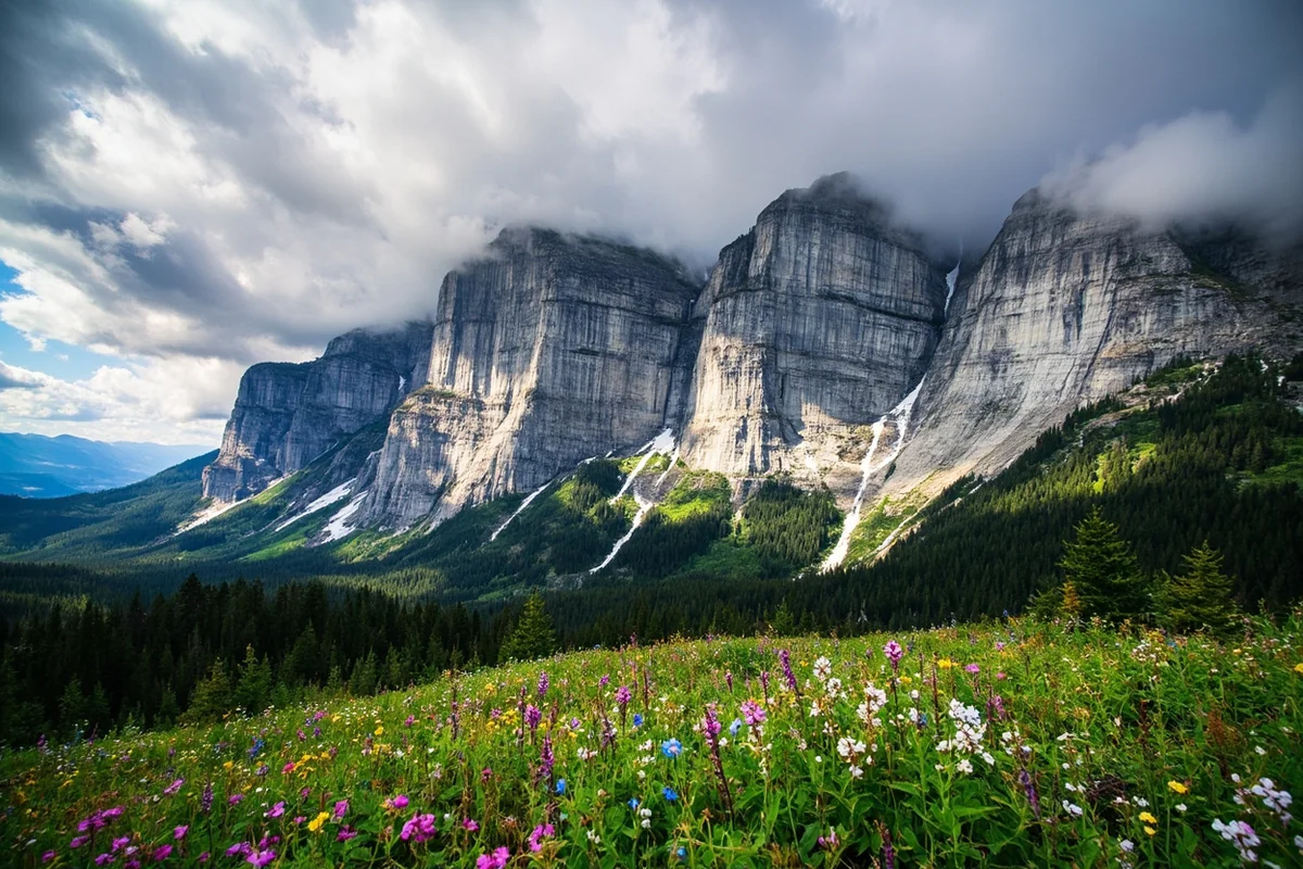
The signature feature of the Bob is the Chinese Wall — a 22-mile-long limestone escarpment that rises 1,000 feet vertically from the forest floor and runs along a section of the Continental Divide.
Getting to the Chinese Wall requires either a multi-day backpacking trip (typically 3–4 days from the nearest trailhead) or an approach on horseback via outfitter. Most visitors who reach it remember it for the rest of their lives.
Key access points into the Bob:
- Benchmark Trailhead (north of Augusta via Forest Road) — primary south-side entry; dusty, remote road; excellent base camp
- Spotted Bear Ranger Station (south side; Hungry Horse area) — southern access with river float options
- Schafer Meadows (accessible by small plane or long trail) — USFS maintains a small airstrip for wilderness resupply
What to know: The Bob is horse country as much as hiker country. Outfitters with horse support can cover the distances more efficiently. If going on foot, plan for a minimum 3-day trip to get meaningfully into the wilderness, and carry a satellite communicator.
Jewel Basin Hiking Area
Jewel Basin is a 15,000-acre zone within the Flathead NF that is designated exclusively for non-motorized, foot-travel use — no horses, no mountain bikes, no motorcycles. The result is some of the most peaceful alpine hiking in northwest Montana.
Within Jewel Basin’s compact terrain are 35 named lakes, dramatic ridgeline views, and a trail network that’s well-enough maintained to navigate without GPS while remote enough to feel genuinely wild.
I spent two nights in Jewel Basin in early September — the larch trees in the upper basins were beginning to turn gold, the lakes were clear enough to watch cutthroat trout cruising 10 feet below the surface, and I passed maybe six other hikers in three days.
Getting there: From Bigfork, take Echo Lake Road east to the Jewel Basin trailhead. The road is paved most of the way.
Top routes:
- Birch Lake — 7 miles round-trip from Camp Misery trailhead, the most popular route
- Picnic Lakes — longer alternative, beautiful subalpine setting
- Mt. Aeneas — 8 miles round-trip; strenuous summit with panoramic views
No reservation or permit required for day hiking. Camping within Jewel Basin is permitted with standard Leave No Trace practices.
Top Trails Beyond the Bob and Jewel Basin
Holland Falls National Recreation Trail
This is the Flathead’s most accessible showcase hike: 1.8 miles one-way along the shore of Holland Lake to a two-tiered waterfall with a 40-foot upper drop.
The Holland Lake Lodge sits at the trailhead, which means you can finish a hike with a lakeside drink if you’re inclined. I’ve done this trail with a 6-year-old — it’s that manageable, and that rewarding.
- Distance: 3.6 miles round-trip
- Difficulty: Easy-moderate
- Trailhead: Holland Lake, off Swan Highway 83
Danny On Memorial Trail
Named after a beloved USFS ecologist, this 8-mile trail climbs 2,000 feet from Whitefish Mountain Resort to the summit of Big Mountain.
The trail is accessible from the resort base and can be completed in conjunction with a lift ride for a one-way descent.
In summer, the summit views take in Glacier National Park’s peaks, Flathead Lake to the south, and Canada to the north.
- Distance: 8 miles one-way (base to summit)
- Difficulty: Strenuous
The Wild and Scenic Rivers
Three forks of the Flathead River — North, Middle, and South — all carry Wild and Scenic River designations, making them among the most protected river corridors in the country. Each fork has a distinct character:
South Fork: The wildest — 60 miles through the Bob Marshall Wilderness without crossing a road. Floatable in rafts or inflatable kayaks; Class II-IV depending on water levels. I did a 4-day float of the South Fork and it remains one of the best things I’ve done in Montana.
Middle Fork: Runs along the southern boundary of Glacier National Park through the Great Bear Wilderness. Class III-IV whitewater; multiple commercial float operators based in Hungry Horse.
North Fork: More mellow, forming the western boundary of Glacier NP. Good for canoe and kayak touring; several access points along the North Fork Road.
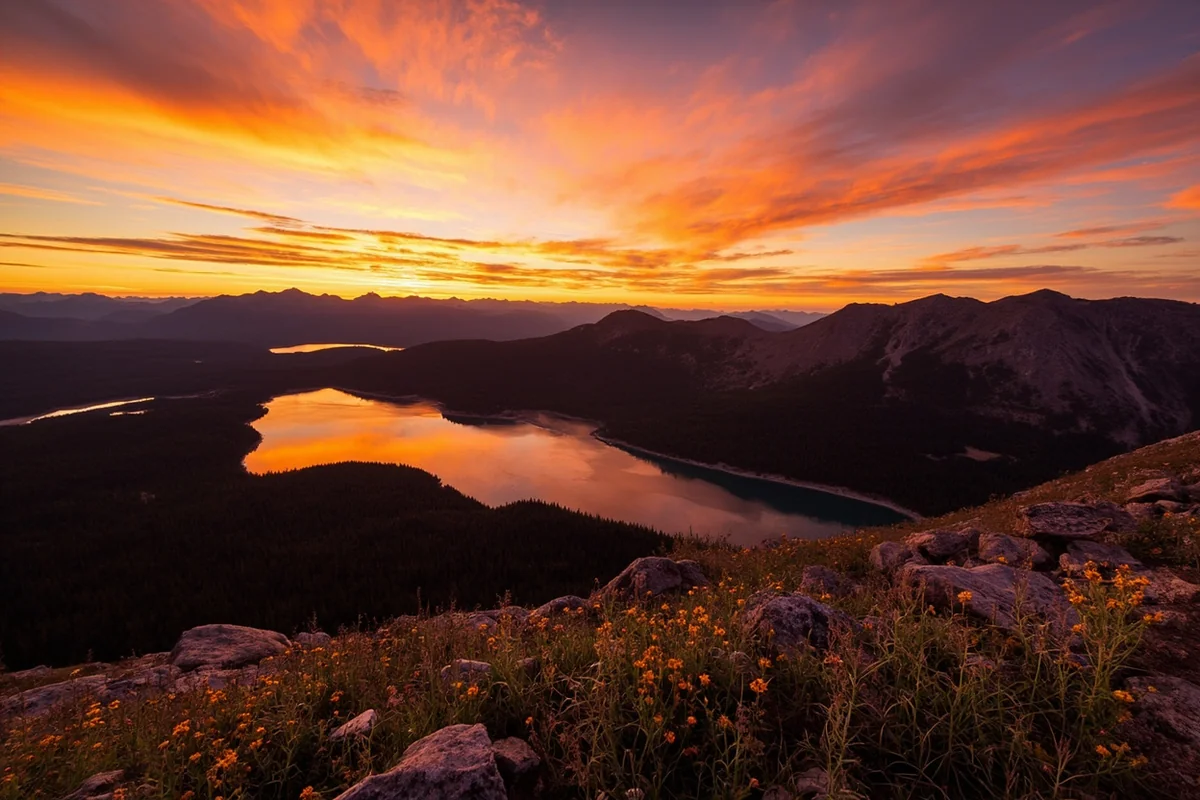
Hungry Horse Reservoir and Surrounding Area
Hungry Horse Reservoir stretches 34 miles through a forested canyon behind the 564-foot Hungry Horse Dam, providing a major recreation hub with boat launches, developed campgrounds, and dozens of miles of forest roads.
The reservoir holds lake trout and various species of kokanee salmon; deepwater trolling is the primary technique.
For most visitors, Hungry Horse Reservoir is a quieter, more accessible alternative to the backcountry: good car camping, boat access, and day hikes into the surrounding hills without the planning required for wilderness travel.
Camping in the Flathead National Forest
Developed Campgrounds
| Campground | Fee | Notes |
|---|---|---|
| Swan Lake | ~$20/night | Lakefront; kayak/paddleboard rentals; 38 sites |
| Emery Bay | ~$18/night | Hungry Horse Reservoir; boat launch |
| Murray Bay | ~$16/night | Hungry Horse east shore; 20 sites |
| Ashley Lake North | Free | No water; lakefront; primitive |
| Red Meadow Lake | ~$10/night | High elevation; CDT access; no water |
[Verify current fees at Recreation.gov or USFS Flathead NF]
USFS Rental Cabins
- Mission Lookout Cabin (~$45/night) — 40-foot tower above the forest; views of Mission Mountains; gas range; no water or electricity
- Hornet Lookout Cabin (~$40/night) — 360° views of Glacier NP and Kintla Lake; wood stove; no water; closed November–mid-June
- Anna Creek Cabin (~$75/night) — West shore of Hungry Horse Reservoir; sleeps 12; running water; road-accessible
- Old Condon Ranger Station (~$85/night) — 3 bedrooms; sleeps 8; full kitchen; Swan Valley setting
- Swan Guard Station (~$70/night) — Oldest building in the Flathead NF (built 1909); refurbished; hand pump water outside
[Verify current rates and availability at Recreation.gov]
Wildlife in the Flathead National Forest
The Flathead NF supports the full Northern Rockies wildlife community, with some notable standouts:
Wolverines: The Mission Mountains Wilderness and Flathead’s high terrain are among the best wolverine habitat in the lower 48. You almost certainly won’t see one (they’re that rare), but wolverine tracking studies have confirmed multiple individuals in the area.
Grizzly bears: The Flathead is core habitat — multiple active grizzly family groups use the forest’s wilderness areas year-round. Bear spray is non-negotiable for any Flathead backcountry travel.
Wolves: Gray wolves range through the wilderness areas. The North Fork area has had some of the longest-tenured wolf packs in Montana.
Mountain goats: Visible from the Jewel Basin ridgelines and high sections of the Bob.
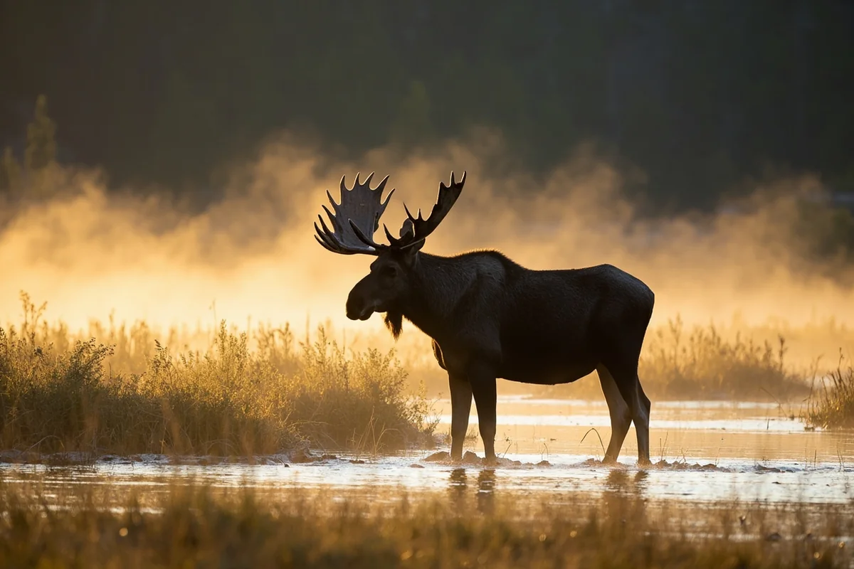
Moose: The Swan Valley corridor — running south through the forest from Swan Lake, where the Flathead NF meets the Lolo National Forest — holds unusually high moose densities. Drive Swan Highway 83 at dawn in September for reliable moose sightings.
Winter Recreation: Whitefish Mountain Resort
Whitefish Mountain Resort sits on Big Mountain within the Flathead NF, operating under a USFS special use permit. The resort offers 3,000+ acres of skiable terrain, 2,353 feet of vertical drop, 105 trails, and a mountain village at the base. Snowfall averages around 300 inches per year.
Beyond resort skiing, the Flathead offers 157 miles of designated snowmobile trails and extensive cross-country skiing on ungroomed Forest Service roads. The Whitefish area Nordic ski trails are groomed separately by the Glacier Nordic club.
Practical Info
| Category | Details |
|---|---|
| General access | Free |
| Campground fees | Free–~$25/night [verify] |
| Nearest airports | Glacier Park International (FCA), Kalispell — 20 min from Kalispell |
| Main gateways | Kalispell, Whitefish, Columbia Falls, Hungry Horse |
| USFS office | Kalispell — (406) 758-5204 |
| Bob Marshall info | Spotted Bear RS: (406) 387-3800 (seasonal) |
| Bear spray | Required for all backcountry travel |
| Key maps | Bob Marshall Wilderness map (Rocky Mountain Surveys) |
What I Wish I Knew Before My First Flathead Trip
The road to the Benchmark Trailhead is long and dusty. Plan for 1.5–2 hours from Augusta on a good gravel road. It’s passable by regular vehicles in summer but you’ll want something with reasonable clearance. Check with the USFS Augusta Ranger Station for current road conditions.
The Bob is horse country. Many interior trails are heavily used by outfitters with stock, and trail conditions on multi-use routes reflect that. If you’re a hiker who minds muddy, heavily churned trail conditions, research which trails are foot-only before planning your route.
Book Jewel Basin camping early. Despite having no formal reservation system, Jewel Basin fills on summer weekends. Aim for early-week arrivals in July and August.
FAQs: Flathead National Forest
Do I need a permit to enter the Bob Marshall Wilderness?
Currently no permit is required, but group size limits apply (typically 12 people and/or stock). No motorized or mechanized equipment is allowed. Always check with USFS for current regulations before a trip.
Can I see Glacier National Park from the Flathead National Forest?
Yes — from numerous ridgelines in Jewel Basin, the Danny On Trail summit on Big Mountain, and along the North Fork Road, you have excellent views into Glacier’s peaks. The Great Bear Wilderness directly abuts Glacier’s southern boundary.
Is Hungry Horse Reservoir good for swimming?
Yes. Several campgrounds along the reservoir have beach access. Water is typically cold (it’s mountain snowmelt) but swimmable in July and August.
How do I access the South Fork of the Flathead for a float trip?
The primary put-in is at Meadow Creek Gorge, accessible via forest road from the Hungry Horse side. Take-out is at Spotted Bear. Commercial outfitters in the Kalispell area offer guided South Fork float trips that include all logistics.
Some Forests You Read About. This One You Plan Your Life Around.
The Bob Marshall Wilderness is one of those places that changes how you think about wilderness as a concept.
After you’ve been in the Bob — genuinely in it, not just adjacent to it — your tolerance for calling a busy trailhead with full cell service a “wilderness experience” drops significantly. The scale recalibrates you.
The Flathead National Forest as a whole operates at that scale. It isn’t just the Bob — it’s the South Fork float, and Jewel Basin’s larch forest in October, and the storm that comes in over Hungry Horse Reservoir while you’re on the water and you have to make decisions quickly about where to get off the lake.
It’s a forest that requires you to be present, prepared, and genuinely paying attention to what’s around you. Montana travelers who find that appealing will find the Flathead one of the richest public land systems in the West.
Our Montana national forests guide gives the full context on how the Flathead relates to the other six national forests in Montana.
If you’re coming in through Whitefish or Kalispell and want to layer in some creature comforts alongside your backcountry time, our guide to things to do in Whitefish is a natural companion.
Questions about the Bob Marshall, Jewel Basin, or the South Fork float? Leave them in the comments — or save this post for your northwest Montana planning.
Explore the Full Montana National Forests Series
← Back to the Montana national forests guide
Also in this series: