I drove into the Bitterroot Valley for the first time on a September evening when the light was going golden across the Sapphire Mountains and the air smelled like pine and something sweet I couldn’t quite name.
By the time I’d pulled over twice to stare at the sheer vertical walls rising from the canyon mouths on the Idaho side of the range, I understood something important: the Bitterroot National Forest doesn’t ease you in. It just starts.
- Bitterroot National Forest covers approximately 1.6 million acres in southwest Montana and eastern Idaho — half of it dedicated wilderness.
- The Selway-Bitterroot Wilderness, shared with Idaho’s Nez Perce-Clearwater National Forest, is one of the largest roadless wilderness areas in the lower 48.
- Top activities: hiking Blodgett Canyon, backpacking the Selway-Bitterroot, fishing the Bitterroot River and its tributaries, skiing at Lost Trail Ski Area.
- Access is free; developed campgrounds run free to $25/night; seven USFS rental cabins are available on Recreation.gov.
- Best base towns: Hamilton (north), Darby (south).
What Is the Bitterroot National Forest?
Established in 1898 as one of Montana’s earliest protected federal reserves, the Bitterroot National Forest today encompasses approximately 1.6 million acres spread across southwest Montana and a slice of eastern Idaho.
It is administered by the USFS Northern Region from its main office in Hamilton, Montana.
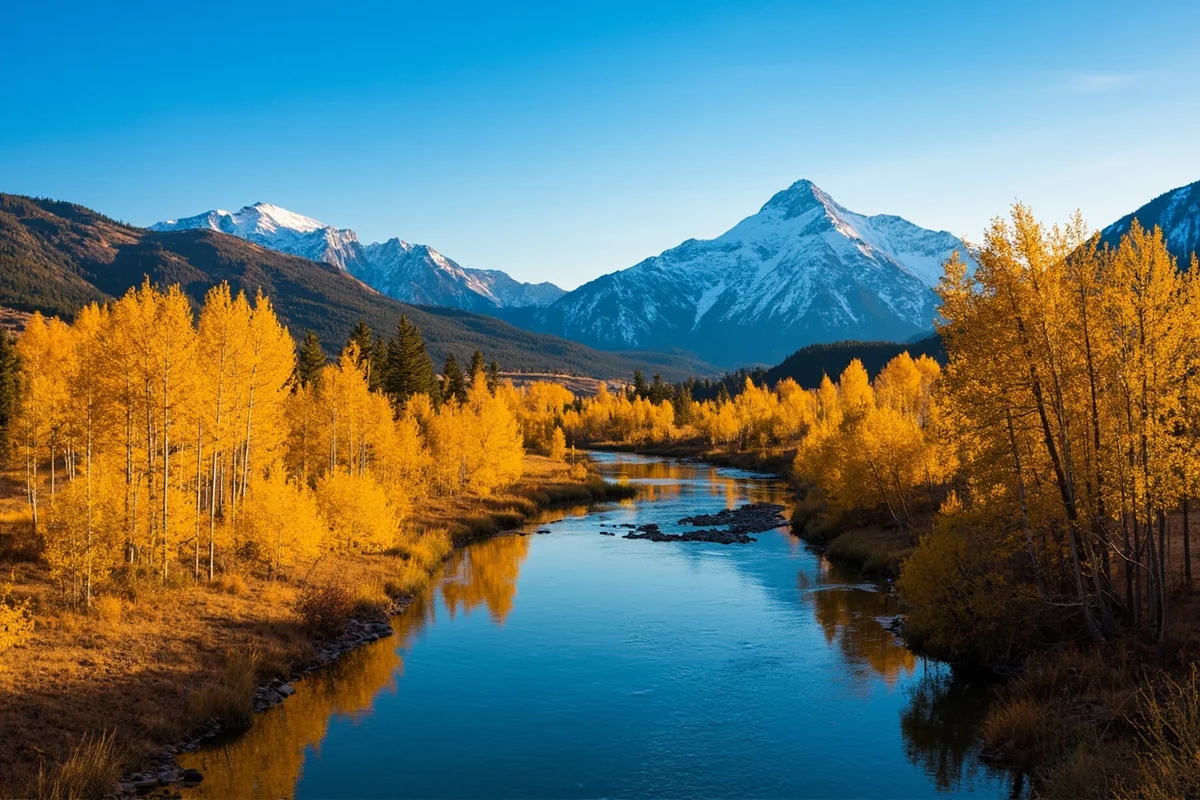
The forest takes its name from the Bitterroot flower — Montana’s state flower — which carpets the valley’s lower slopes in early summer with small pink blooms that seem impossibly delicate against the backdrop of granite peaks.
The Bitterroot River runs the length of the valley between the mountain ranges on either side.
Quick Stats:
| Category | Details |
|---|---|
| Established | 1898 |
| Total Acreage | ~1.6 million acres |
| Location | SW Montana + eastern Idaho |
| Wilderness Areas | Selway-Bitterroot, Frank Church-River of No Return (partial), Anaconda-Pintler (partial) |
| Highest Point | Trapper Peak — 10,157 ft |
| Ranger Districts | Stevensville, Darby, Sula, West Fork |
| Main Office | Hamilton, MT — (406) 363-7100 |
| Best Season | July–September (trails); November–April (skiing) |
The Landscape: Two Mountain Ranges, One Valley
What makes the Bitterroot geographically distinctive is its position between two very different mountain ranges.
To the west, the Bitterroot Mountains rise in dramatic, steep-walled canyons carved by glaciers — sheer rock faces and hanging lakes that feel almost Yosemite-like in their verticality.
To the east, the Sapphire Mountains offer a gentler, rolling character: open ridgelines, grassland parks, and creek drainages that feel more intimate and accessible.
The valley floor between them hovers around 3,500 feet elevation — comfortable and relatively warm by Montana standards — while the highest peaks on the western divide top 10,000 feet.
That 6,500-foot elevation range within a 20-mile horizontal distance creates dramatic ecological contrasts: ponderosa pine savannas and bitterbrush scrub at the bottom, dense Douglas-fir and lodgepole pine mid-mountain, subalpine fir and whitebark pine near the ridge crests, and above treeline, a world of rock, snowfield, and summer wildflowers.
I’ve hiked from the valley floor into the wilderness in a single long day and felt like I’d traveled through three different climates.
Top Trails in the Bitterroot National Forest
Blodgett Canyon Trail
Blodgett Canyon is the trail I recommend to anyone visiting the Bitterroot for the first time. The canyon begins a few miles west of Hamilton via a forest road and opens almost immediately into a world defined by sheer pink granite walls that rise several thousand feet above you on both sides.
Blodgett Creek runs along the canyon floor through boulders and pools, and the trail follows it upstream for about 9 miles one-way before reaching Blodgett Lake.
I did this trail on a Thursday in late August and had the first 5 miles nearly to myself. The rock climbers were the only other humans I encountered — the canyon’s south-facing walls host some of the most serious technical climbing routes in western Montana. If you’re not a climber, you can still gawk freely.
- Distance: 9 miles one-way to the lake (18 miles out-and-back, or backpack in for 2+ nights)
- Difficulty: Moderate (gradual grade with some boulder-hopping)
- Elevation gain: ~2,200 ft to Blodgett Lake
- Trailhead: Blodgett Canyon Trailhead, 4.5 miles west of Hamilton off Ricketts Road
Trapper Peak Trail
At 10,157 feet, Trapper Peak is the highest summit in the Bitterroot Range and one of the more accessible high peaks in the Montana Rockies.
The trail climbs approximately 4 miles and 3,700 vertical feet from the trailhead via an approach that starts in the timber and eventually reaches an exposed ridge walk to the summit.
I did it in early September with three inches of fresh snow on the upper section — traction devices helped, though many people complete it in running shoes in good conditions.
The views from the summit are legitimately staggering: the Selway-Bitterroot Wilderness stretches unbroken to the Idaho horizon, and on a clear day you can see the Anaconda-Pintler peaks to the northeast — the high backbone of the Beaverhead-Deerlodge National Forest.
- Distance: 8 miles out-and-back
- Difficulty: Strenuous
- Elevation gain: ~3,700 ft
- Trailhead: Off Troy Creek Road, south of Darby
Blodgett Overlook Trail
For a shorter commitment with big payoff, the Blodgett Overlook Trail climbs 3 miles to a viewpoint perched above the canyon. It’s a good option for families or anyone who wants the visual drama without committing to an all-day canyon traverse.
- Distance: 6 miles out-and-back
- Difficulty: Moderate
- Elevation gain: ~1,500 ft
Mill Creek Trail
One of the better-kept secrets in the Stevensville Ranger District, Mill Creek Trail enters the Selway-Bitterroot Wilderness and passes through old-growth ponderosa pine in the lower section before climbing into the higher granite country.
I ran into a black bear on this trail in June — she was more startled than I was, and bolted uphill before I’d even had time to raise my arms.
- Distance: 6 miles to Mill Lake (one-way)
- Difficulty: Moderate-strenuous
The Selway-Bitterroot Wilderness
Half of the Bitterroot National Forest’s acreage is dedicated to wilderness, and the Selway-Bitterroot is the centerpiece.
At about 1.3 million acres straddling the Montana-Idaho border (the Bitterroot NF manages the Montana portion, while the Lolo National Forest administers portions to the north), it is the fourth-largest wilderness area in the contiguous United States.
Within it: no roads, no motorized vehicles, no mechanized equipment (including mountain bikes). Trails range from well-maintained Forest Service routes to faint bootpaths that disappear in high basins.
I’ve been in the Selway-Bitterroot three times — twice from the Montana side, once via Idaho — and in three separate trips I’ve encountered more grizzly sign than other hikers.
What to know before entering:
- No wilderness permit currently required (check USFS for any recent changes)
- Group size limit: 12 people and/or stock per group
- Camp 200 feet from water and trails
- Bear canisters or hang bags strongly recommended — grizzlies are present
- Satellite communicator essential for any multi-day trip
Camping in the Bitterroot National Forest
Dispersed Camping
Dispersed camping is allowed throughout most of the Bitterroot National Forest outside of designated campgrounds, day-use areas, and wilderness entry zones.
The rules: 200 feet from water and trails, pack out everything, 14-day stay limit. This is free camping, and the west-side canyon forest roads provide access to some genuinely remote spots.
Developed Campgrounds
The Bitterroot has over 20 developed campgrounds ranging from primitive (no water, no fee) to semi-developed with water and vault toilets. A selection:
| Campground | Fee | Sites | Notes |
|---|---|---|---|
| Lake Como Campground | ~$25/night | Multiple | RV hook-ups, beach access, boat ramp |
| Alta Campground | ~$15/night | 15 | Reservations required; near Painted Rocks Lake |
| Charles Waters | ~$15/night | 26 | Near Bass Creek Recreation Area; host on-site |
| Deep Creek | Free | 3 | Primitive; good fishing access |
| Sam Billings Memorial | Free | 12 | Large group site; vault toilets only |
| Warm Springs | ~$12/night | Multiple | Cutthroat trout fishing; no reservations |
[Verify current fees with USFS Bitterroot NF before visiting]
USFS Rental Cabins
The Bitterroot has one of the better cabin rental programs in the Northern Region. Several historic lookouts and guard stations are available through Recreation.gov, typically for $30–$100/night. Notable options:
- Gird Point Lookout (~$30/night) — 11 miles from Hamilton; 360-degree views of Pintler, Sapphire, and Anaconda Mountains; propane heat/cooking, no water or electricity
- Wood’s Cabin (~$100/night) — Lake Como lakefront; sleeps 15; two wood stoves
- East Fork Cabin (~$50/night) — Historic 1914 guard station; East Fork Bitterroot River; excellent fishing access
- McCart Lookout (~$30/night) — East of Sula; sleeps 8; has electricity
- Magruder Ranger’s House (~$100/night) — Selway River; 5 rooms; running water; road-accessible
[Verify current availability and rates on Recreation.gov]
Fishing in the Bitterroot
The Bitterroot River is a blue-ribbon fishery in the strictest sense — a blue-ribbon designation from Montana FWP means it supports self-sustaining populations of wild trout without stocking.
The river holds brown trout (the dominant species in the lower river), westslope cutthroat (more prevalent above Darby), and rainbow trout throughout.
The west-side canyon creeks — Blodgett, Bass, Mill, Sleeping Child, and others — hold native westslope cutthroat that are increasingly rare elsewhere in the Rocky Mountain West. These fish are smaller than the river browns but wild and spooky in a way that makes them genuinely satisfying to catch.
I’ve had my best Bitterroot fishing in September, when the heat of August has passed, the aquatic insect activity picks back up, and the streamside crowds have thinned significantly.
A good chunk of the Bitterroot River is accessible via public fishing easements — check the Montana FWP access map before heading out.
A Montana fishing license is required. [Verify current fees at montanafwp.gov]
Wildlife in the Bitterroot National Forest

The Bitterroot hosts what is arguably the most diverse large mammal community of any national forest in the Northern Rockies. The valley floor’s farmland-forest interface supports high densities of white-tailed deer and mule deer.
Mountain goats occupy the high crags above Blodgett and Blodgett Canyon. Black bears are present throughout the forest and frequently encountered on trails.
Grizzly bears are a growing presence in the Bitterroot. The forest falls within the Cabinet-Yaak and Northern Continental Divide Ecosystem recovery zones.
I’ve found grizzly tracks twice in the Selway-Bitterroot — once in snow near the Idaho divide in October, once in mud at a stream crossing in early June. Carry bear spray and know how to deploy it. This is not paranoia; it’s standard practice.
Other species to watch for: mountain lions (rarely seen but present), elk (especially in the Sula area in fall), moose (scattered through the wetter north-side drainages), and both bald and golden eagles year-round.
Winter Recreation
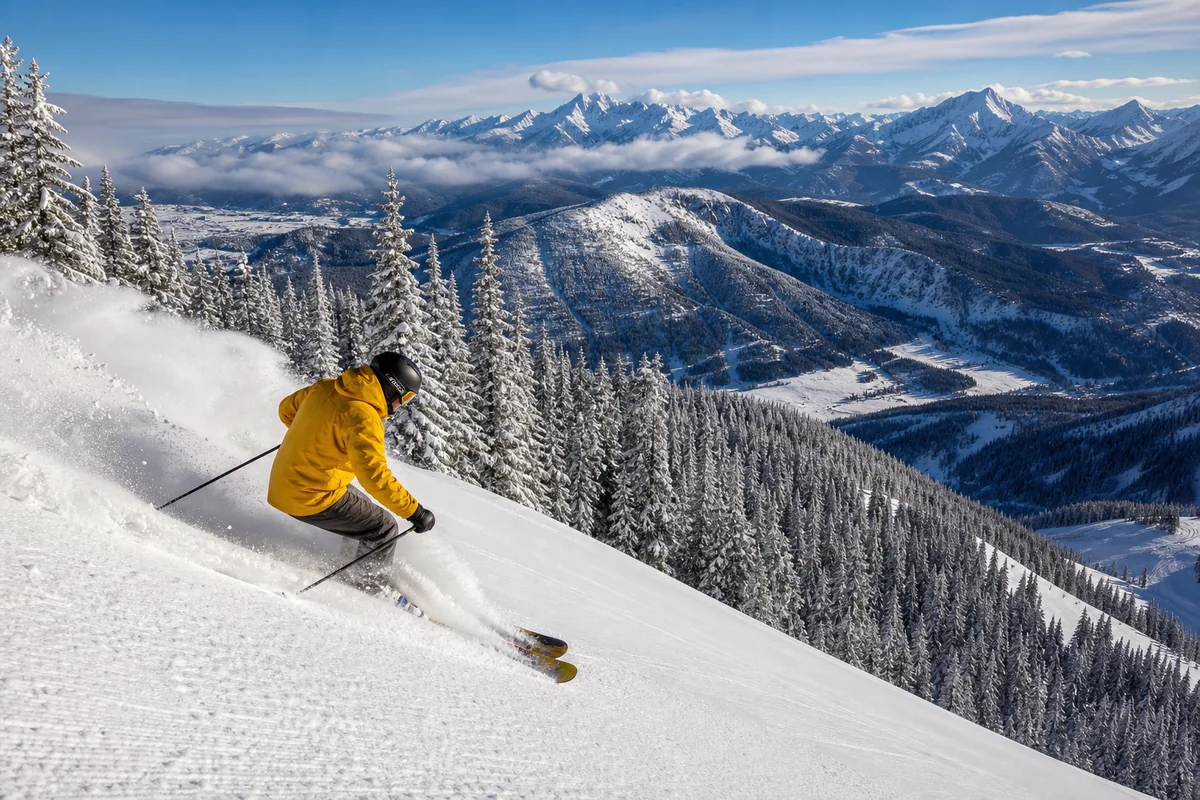
Lost Trail Ski Area sits right at the Bitterroot-Idaho border on the Continental Divide, operating under a Forest Service permit within the Bitterroot NF. Family-owned since 1938, it gets consistently good snow from storms tracking in off the Pacific, and its location on the divide means it often catches powder that misses the valley entirely.
It’s a locals’ mountain — no pretense, honest terrain, reasonable prices. [Verify current lift ticket prices at losttrail.com]
Beyond Lost Trail, the forest road system provides snowmobile access through much of the west side in winter. The Sula area (south end of the valley) has maintained snowmobile trails and is a popular winter weekend destination from Missoula and Hamilton.
Practical Info
| Category | Details |
|---|---|
| General access | Free |
| Campground fees | Free–~$25/night [verify] |
| Cabin rentals | $30–$100/night via Recreation.gov [verify] |
| Nearest airport | Missoula Montana Airport (MSO), ~45 min from Hamilton |
| Main gateway | Hamilton, MT (north); Darby, MT (south) |
| Cell service | Good in Hamilton/Darby; none in most canyons and wilderness areas |
| Maps | Free MVUM at USFS Hamilton office; available at usfs.usda.gov |
| USFS phone | (406) 363-7100 |
| Website | fs.usda.gov/bitterroot |
| Bear spray | Required recommendation for all backcountry travel |
What I Wish I Knew Before My First Bitterroot Trip
The west-side canyons are longer than they look on the map. What appears to be a short approach on a topo map often involves 5 miles of forest road (sometimes rough) before you even reach the trailhead. Add 30 minutes to any drive estimate in this forest.
The Bitterroot River changes character north to south. Above Darby, it’s more classic wade-fishing cutthroat water — clear, fast, intimate. Below Hamilton, it widens and browns become more dominant. Match your technique to the reach you’re fishing.
September is genuinely magical here. The cottonwoods along the river go gold in late September, the mountains get dusted with early snow, and the trail traffic drops by at least 70% from the August peak. My single best day of fishing in this valley was September 14 on the West Fork above Painted Rocks Lake.
FAQs: Bitterroot National Forest
Is the Bitterroot National Forest free to enter?
Yes. There’s no entry fee for the national forest. Fees apply at some developed campgrounds (free to ~$25/night) and USFS rental cabins ($30–$100/night). Dispersed camping is always free.
Can I take my dog to Bitterroot National Forest?
Yes. Dogs are allowed in the national forest and on most trails. They must be under voice or physical control, and given the grizzly presence in the Selway-Bitterroot Wilderness, a leash is strongly advisable on backcountry trails.
Do I need a permit to hike the Selway-Bitterroot Wilderness?
Currently, no day-use permit is required. Group size is limited to 12 people and/or stock. Always check with the USFS Bitterroot NF office before a trip for any updated requirements.
What is the best time of year to visit Bitterroot National Forest?
July through September for hiking and backpacking; high-elevation trails typically clear of snow by mid-July. Lost Trail Ski Area operates December through April depending on snowpack. Fall (late September–October) is the best-kept secret: stunning cottonwood and aspen color, excellent fishing, and minimal crowds.
Is there grizzly bear habitat in the Bitterroot National Forest?
Yes. Grizzly bears are present in and around the Selway-Bitterroot Wilderness. Always carry bear spray and practice proper food storage. Black bears are also common throughout the forest.
The Bitterroot Is Waiting
I keep coming back to the Bitterroot for the same reason I keep coming back to most places in Montana that I love: it hasn’t been fully discovered yet. You can still hike into Blodgett Canyon on a summer weekday and have the walls to yourself.
You can still find a dispersed campsite on a West Fork forest road with the creek twenty feet from your tent and no one within earshot. You can still catch wild cutthroat on a dry fly in a canyon stream that doesn’t have a name on most maps.
The Bitterroot National Forest rewards the traveler who slows down and goes deeper. Pick one canyon and spend a full day in it. Fish the same river reach two mornings in a row and learn its moods.
Drive the back road between Darby and Sula in the evening when the light goes gold across the Sapphire crest. This forest will meet you halfway — but only if you show up with some patience.
For more on planning your broader Montana trip, our Montana national forests guide covers how the Bitterroot fits into Montana’s full public lands picture. And if a soak after a long trail day sounds like the right ending to your visit, Lolo Hot Springs is an easy drive north on Highway 93.
Pin this post for your next Southwest Montana trip, or drop your Bitterroot questions in the comments — I’m happy to help you plan.
Explore the Full Montana National Forests Cluster
← Back to the Montana national forests guide
Also in this series: