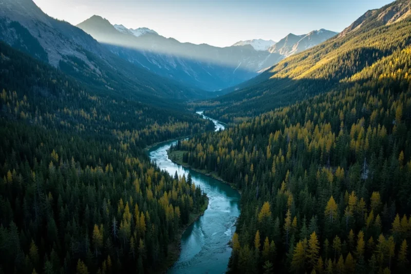
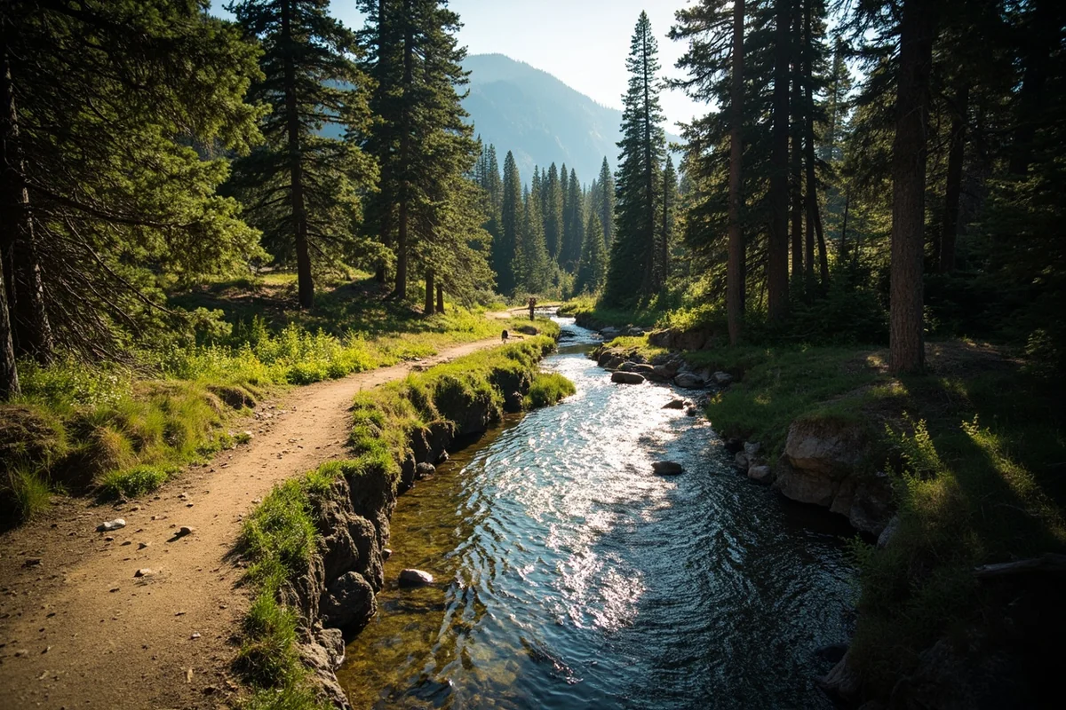
I’ve lived in Missoula’s orbit long enough to know that when you have a bad day, you drive to the Rattlesnake. You park at the trailhead on Rattlesnake Creek Road, walk 20 minutes past the city boundary, and everything urban falls away. The only sounds are your boots on gravel and the creek running beside you.
That’s what it means to have the Lolo National Forest as your backyard — 2 million acres of mountains, rivers, wilderness, and forest beginning approximately 5 minutes from downtown Missoula. But the Lolo is also Rock Creek and the Blackfoot and the Clark Fork.
It’s the Seeley Lake chain and the Swan Range and the high country of the Selway-Bitterroot in its eastern reaches. It’s Lolo Hot Springs at the end of a good hike on Highway 12.
The Lolo is many things, and it’s the national forest that most Montanans have actually been to, whether they realized it or not.
- Lolo National Forest covers 2 million acres in west-central Montana, centered on Missoula.
- Home to the Rattlesnake Wilderness (20 min from downtown Missoula), Rock Creek, the Blackfoot River, Seeley Lake, and portions of the Selway-Bitterroot and Scapegoat Wildernesses.
- One of the most accessible national forests in Montana — multiple trailheads within 30 minutes of Missoula.
- Lolo Hot Springs sits on the forest’s western boundary on Highway 12.
- Outstanding year-round recreation: hiking, fishing, snowmobiling, Nordic skiing, paddling.
Overview: A High-Diversity Forest
The Lolo National Forest stretches from the Idaho border near Lolo Pass east through Missoula to the western reaches of the Bob Marshall country and south to the Selway-Bitterroot Wilderness boundary.
It encompasses the Clark Fork River corridor, the Blackfoot River valley, the Seeley-Swan corridor, Rock Creek, and the mountains of the Idaho-Montana divide.
“High-diversity” is the USFS description of the Lolo’s character, and it’s accurate. The forest ranges from ponderosa pine savannas at 3,000 feet elevation in the Clark Fork valley to subalpine larch above 6,000 feet in the Swan Range; from dry, south-facing ridgelines with bunchgrass and cactus to wet, north-facing drainages thick with cedar and cottonwood.
Four wilderness areas lie within or touching the Lolo:
- Rattlesnake National Recreation Area and Wilderness — 59,000 acres; the most accessible wilderness in the Northern Rockies
- Welcome Creek Wilderness — 28,000 acres; in the Rock Creek drainage
- Scapegoat Wilderness (partial) — shared with Helena-Lewis and Clark NF
- Selway-Bitterroot Wilderness (partial) — shared with Bitterroot NF and Idaho forests
Quick Stats:
| Category | Details |
|---|---|
| Total Acreage | ~2 million acres |
| Location | W-central Montana, centered on Missoula |
| Wilderness Areas | Rattlesnake, Welcome Creek, Scapegoat (part), Selway-Bitterroot (part) |
| Wild and Scenic Rivers | Lolo Creek drainage |
| Campgrounds | 50+ |
| USFS Office | Missoula — (406) 329-3750 |
| Best Season | Year-round; July–Sept (high country); Nov–March (snowmobiling/Nordic) |
The Rattlesnake Wilderness and Recreation Area
The Rattlesnake is the best argument for living in Missoula that I know of. Twenty minutes from the city center, you can park at the Rattlesnake Creek trailhead and enter a 59,000-acre wilderness and recreation area that includes 30+ miles of trails, dozens of backcountry lakes, and a primitive solitude you wouldn’t expect to find this close to a city of 75,000 people.
The lower Rattlesnake is a recreation area, meaning mountain bikes and dogs are allowed on the main creek trail. The wilderness boundary begins a few miles up the drainage, at which point it becomes hiker and equestrian only.
I’ve been into the upper Rattlesnake lakes in winter on snowshoes — the circuit from Missoula through Poe Lakes and back is one of those Montana winter days that makes you feel genuinely fortunate to live where you live.
Key access: Rattlesnake Creek trailhead on Rattlesnake Creek Road, north of Missoula. Free parking.
Top routes:
- Stuart Peak Trail — 8 miles round-trip; summit views of the Rattlesnake and Missoula Valley
- Poe Lakes — 12 miles round-trip; excellent backcountry lake destination
- Sawmill-Curry Loop — 7 miles; well-marked loop in the lower recreation area; good for families
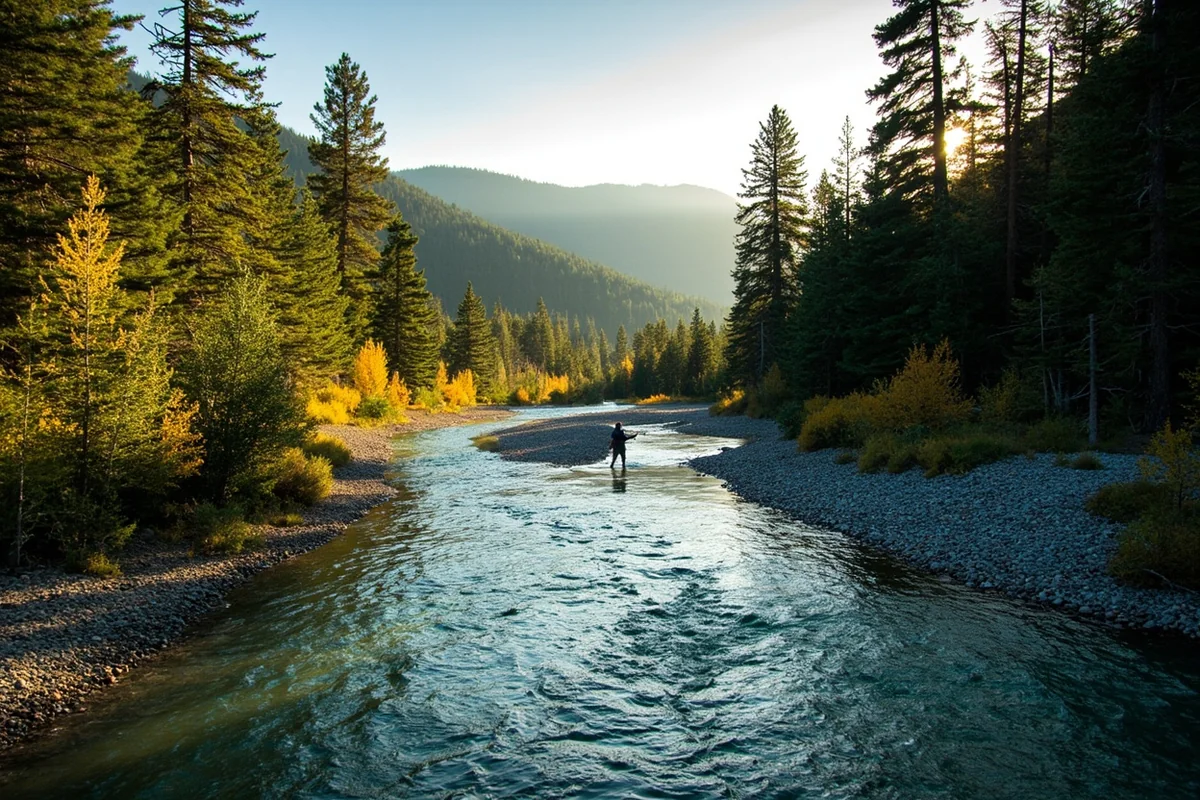
Rock Creek: The Lolo’s Blue-Ribbon Fishery
If there’s one stretch of water in the Lolo National Forest that every serious angler should visit, it’s Rock Creek. A tributary of the Clark Fork southeast of Missoula, Rock Creek runs approximately 50 miles through a steep-walled canyon before reaching the Clark Fork.
The lower section near the highway is well-known and well-fished; the upper canyon, accessible only on foot or horseback, holds wild westslope cutthroat and bull trout in near-pristine habitat.
I’ve fished Rock Creek in June (high and off-color after runoff — technical and challenging), July (ideal — clear water, active hatches, fish rising freely), and late September (the best dry fly fishing of the year, crowds nearly absent).
The September visit was the one that made me understand why Montanans don’t often volunteer information about Rock Creek to visitors.
The Welcome Creek Wilderness begins east of the main drainage and provides the headwaters protection that keeps Rock Creek clean. No motorized vehicles or mechanized equipment are allowed in the wilderness.
Regulations: Rock Creek has been under special regulations at various times; check current Montana FWP regulations before fishing — bull trout are protected and must be released. [Verify current Rock Creek regulations at montanafwp.gov]
Montana fishing license required.
The Blackfoot River
Norman Maclean’s novella A River Runs Through It describes fly fishing on the Blackfoot River in the early 20th century.
The river today runs through Lolo National Forest land along much of its upper drainage and remains one of the most culturally significant fishing rivers in Montana — and one of the most restored.
The Blackfoot suffered significant degradation through the 20th century from mining runoff, irrigation diversions, and riparian damage.
The Blackfoot Challenge — a community-based partnership involving landowners, conservation groups, and state agencies — has spent the last 30+ years restoring the river.
The results are remarkable: westslope cutthroat populations have recovered substantially, and the river fishes better now than it has in generations.
Access: Highway 200 follows the lower Blackfoot from Missoula east through the river canyon, with multiple public access points. The upper Blackfoot on Lolo National Forest land above Lincoln is reached via the Alice Creek area and is accessible to both waders and floaters in appropriate watercraft.
Seeley Lake: The Lolo’s Year-Round Playground
Seeley Lake sits in the Seeley-Swan Valley — a long corridor between the Swan and Mission Mountain ranges that forms the boundary between the Flathead National Forest and the Lolo National Forest.
The town of Seeley Lake is the recreation hub for a chain of lakes (Seeley, Alva, Inez, Rainy) connected by the Swan River.
I’ve been to Seeley Lake in four different seasons:
- Summer: Paddleboarding the lake chain, camping at Seeley Lake Campground, afternoon thunderstorms rolling down the Swan Range
- Fall: Western larch in full gold (the larches around Seeley Lake are spectacular in late September/early October)
- Winter: Snowmobiling on the vast groomed trail network — the Seeley Lake area has some of the best groomed snowmobile trails in western Montana
- Spring: Watching osprey and eagles return to the lake system in April before the summer crowds arrive
The Seeley Lake Campground (operated by USFS) sits directly on the lakeshore. In summer, book through Recreation.gov — it fills on summer weekends. The network of forest roads around the lakes provides extensive dispersed camping options for those who prefer to avoid developed sites.
Lolo Hot Springs
Lolo Hot Springs sits on Highway 12 approximately 35 miles west of Missoula, right at the Lolo National Forest boundary on Lolo Creek.
After a long hiking or fishing day in the Lolo NF, it’s the logical endpoint — outdoor soaking pools in a setting surrounded by national forest land.
We’ve written a complete guide to Lolo Hot Springs here. The short version: outdoor pools, a lodge with cabins and motel-style rooms, and a location on the Lewis and Clark Trail where the expedition camped in both 1805 and 1806.
Top Trails in the Lolo National Forest
Pattee Canyon Recreation Area (Missoula)
Pattee Canyon is the Lolo NF’s closest recreation area to Missoula — a 7-mile road up Pattee Canyon gives access to a network of hiking and Nordic ski trails within 5 minutes of the city. In winter, it’s groomed for cross-country skiing; in summer, it transitions to hiking and mountain biking.
St. Mary’s Peak
Southwest of Stevensville in the Bitterroot Valley (on the boundary between Lolo and Bitterroot National Forests), St. Mary’s Peak offers one of the most panoramic views in the region — the whole of the Bitterroot Valley laid out below with the Bitterroot Mountains to the west and Sapphires to the east.
- Distance: 5 miles round-trip
- Difficulty: Moderate-strenuous
- Elevation gain: 2,300 ft
Marshall Mountain Area
East of Missoula, the Marshall Mountain trails give access to the Rattlesnake country from the south side — a less-used approach to the upper Rattlesnake wilderness that avoids the main creek corridor entirely.
Clearwater Chain of Lakes Trail
In the Seeley area, the Clearwater Chain of Lakes connects multiple small lakes via a forest trail accessible from Highway 83. Good family hiking with opportunities for swimming at each lake. The huckleberries along this trail in late July are some of the best I’ve found in the Lolo.
Camping in the Lolo National Forest
| Campground | Fee | Location | Notes |
|---|---|---|---|
| Seeley Lake | ~$16/night | Seeley Lake | Lakefront; reservations strongly advised in summer |
| Lake Alva | ~$12/night | Swan Valley | Seeley Lake chain; quieter than Seeley |
| Clearwater | ~$10/night | Swan Valley | Chain of lakes; swimming |
| Beavertail Hill | ~$15/night | Clark Fork | River access; near Rock Creek confluence |
| Harry’s Flat | ~$10/night | Rock Creek | 20 sites; good access to lower Rock Creek |
| Dalles | ~$10/night | Rock Creek | 10 sites; riverside; primitive feel |
[Verify current fees at Recreation.gov or USFS Lolo NF]
Dispersed camping is available throughout much of the forest outside designated campgrounds. The Rock Creek drainage east of the highway, the upper Blackfoot Road area north of Lincoln, and the forest roads west of Seeley Lake all provide good dispersed camping access.
Wildlife in the Lolo National Forest
The Lolo supports a broad wildlife community across its varied habitats. Key species and where I’ve found them:
Wolves: The Lolo NF has established wolf packs — the Ninemile Pack, one of Montana’s most-studied wolf families, has historically occupied the Ninemile Valley west of Missoula. Howls from the ridge above Rock Creek Road in spring are one of those sounds I don’t take for granted.
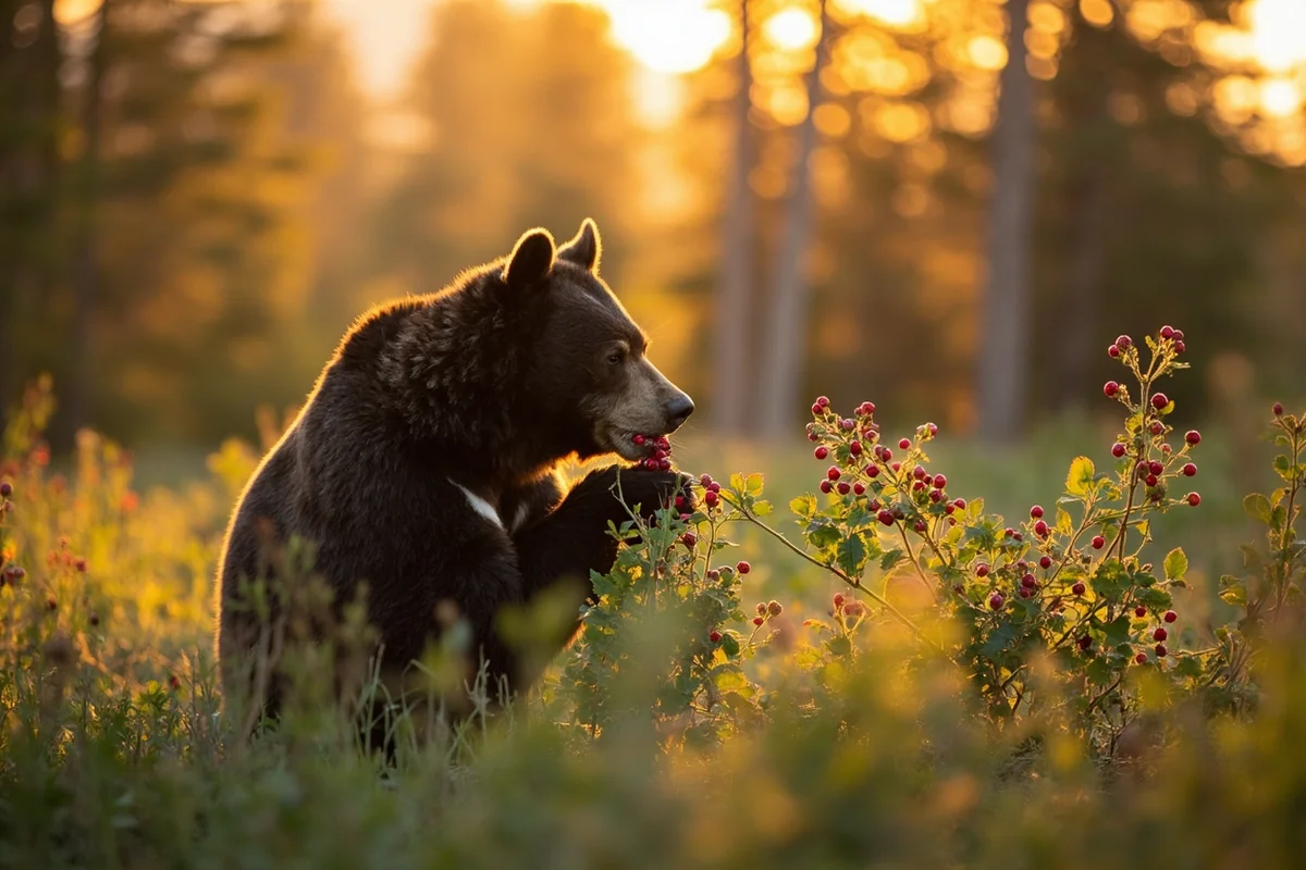
Black bears: Very common, especially in the Seeley Lake area during huckleberry season (late July through August). Bears and hikers encounter each other regularly on Lolo trails — alert hiking practices and proper food storage are essential.
Elk: The Rock Creek and upper Blackfoot drainages hold elk year-round. Fall in Rock Creek canyon produces consistent elk bugling — one of the more moving autumn sounds in the Montana backcountry.
Mountain lions: Present throughout the forest; rarely seen but occasionally encountered by hunters and backcountry travelers in the Rattlesnake and Welcome Creek drainages.
Grizzly bears: The Lolo is on the fringes of the Northern Continental Divide Ecosystem grizzly range. Grizzlies are documented in the upper Rock Creek and Selway-Bitterroot areas. Carry bear spray.
Winter Recreation in the Lolo
The Lolo National Forest is one of the premier snowmobile destinations in western Montana. The Seeley Lake groomed snowmobile trail system extends through the Swan Range into the forest, connecting to hundreds of miles of both groomed and ungroomed routes. The Seeley Lake area Snowmobile Club maintains trails through the season.
Nordic skiing at Pattee Canyon (Missoula) is groomed by the Missoula Nordic Ski Club and provides easy access to groomed trails within minutes of the city. Snowshoeing is allowed throughout the forest road and trail system.
Lolo Pass (on Highway 12 at the Idaho border) is a popular Nordic skiing destination when snow conditions allow — Idaho’s Clearwater National Forest system connects with the Lolo via multiple trail systems.
Practical Info
| Category | Details |
|---|---|
| General access | Free |
| Campground fees | Free–~$20/night [verify] |
| Nearest airport | Missoula Montana Airport (MSO) — 20 min from Missoula trailheads |
| Main gateway | Missoula (primary); Seeley Lake; Thompson Falls; Superior |
| USFS office | Missoula — (406) 329-3750 |
| Cell service | Good near Missoula; limited in Rock Creek, Blackfoot upper drainage, Seeley area |
| Best for | Accessible wilderness near Missoula, fishing, snowmobiling, family camping |
What I Wish I Knew Before My First Lolo Trip
Rock Creek gets crowded in July. The stretch from the canyon entrance to the 18-mile marker is heavily used on summer weekends — boat launches, waders, families. For solitude and better fishing, walk upstream from any access point for 30 minutes. The quality improves dramatically.
The Seeley Lake campground fills by Thursday in peak summer. Book as soon as the Recreation.gov window opens (6 months out for peak summer) or plan for a dispersed site on one of the surrounding forest roads.
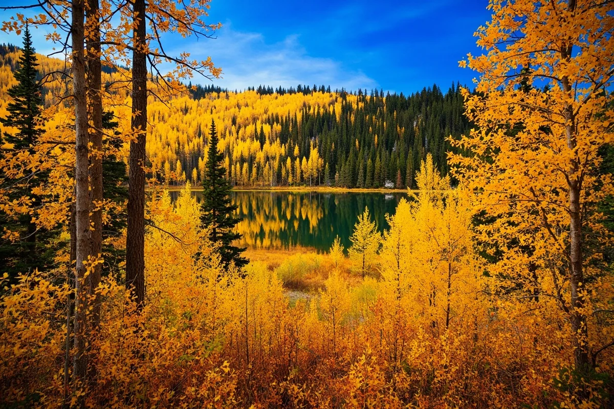
Western larch is the Seeley-Swan’s secret weapon. Unlike most conifers, western larch drops its needles in fall — and when it does, the Swan Range turns gold in a way that rivals anything in the Rockies. The third week of October is typically peak larch color around Seeley Lake.
FAQs: Lolo National Forest
How close is the Lolo National Forest to Missoula?
Very close. The Rattlesnake Wilderness and Recreation Area trailhead is approximately 4 miles from downtown Missoula. Pattee Canyon Recreation Area is about 3 miles. Rock Creek is 25 miles east on I-90. The Lolo genuinely begins where Missoula ends.
Can I mountain bike in the Rattlesnake?
Yes, in the designated Recreation Area (lower section). Mountain bikes are prohibited in the Rattlesnake Wilderness (upper section). The boundary is well-marked. The Rattlesnake Creek trail from the main trailhead to the wilderness boundary is a popular mountain bike route.
Is the Blackfoot River good for beginners to fly fish?
Yes, the lower Blackfoot near Bonner and the river’s middle section near Ovando are wade-fishable for beginners with a guide. The upper reaches on Lolo NF land are more technical. Montana’s fishing access laws give the public the right to use the river up to the high-water mark, so access is good.
What is Lolo Hot Springs and is it worth visiting?
Yes. Lolo Hot Springs is a resort on the Lolo National Forest boundary on Highway 12, offering outdoor soaking pools, lodging, and a restaurant in a genuine national forest setting. It’s on the Lewis and Clark Trail and has a long history of use going back to the Salish people. Our full Lolo Hot Springs guide has everything you need to plan a visit.
Missoula’s Backyard Is the Best Backyard in Montana
The Lolo National Forest is two million acres of proof that proximity to civilization doesn’t have to mean the end of wildness. Twenty minutes from Missoula you can enter a wilderness area.
An hour up Rock Creek you can fish for native cutthroat in a canyon that sees a fraction of the traffic of Montana’s more famous rivers.
In October, the larch around Seeley Lake put on a color display that rivals anything the Rockies have to offer — and most visitors have never heard of it.
This is the forest that taught me what it actually means to have public land as part of your daily life.
Not a destination you plan a trip to, but a place that’s woven into how you spend your weeks — a Tuesday evening hike in the Rattlesnake, a Saturday morning on Rock Creek, a winter afternoon skiing Pattee Canyon before the light goes.
Montana’s national forests are most powerful as a system rather than a collection of individual destinations, and the Lolo is the one that most consistently makes the case.
Our Montana national forests guide gives the full picture of all seven forests and how they connect. If you’re visiting Missoula and want to layer in some of the city’s own charms alongside your Lolo adventures, check out what else western Montana has to offer.
Questions about the Rattlesnake, Rock Creek, Seeley Lake, or the Lolo in general? Leave them in the comments — I’ve spent a lot of time in this forest and I’m happy to point you in the right direction.
Explore the Full Montana National Forests Series
← Back to the Montana national forests guide
Also in this series: