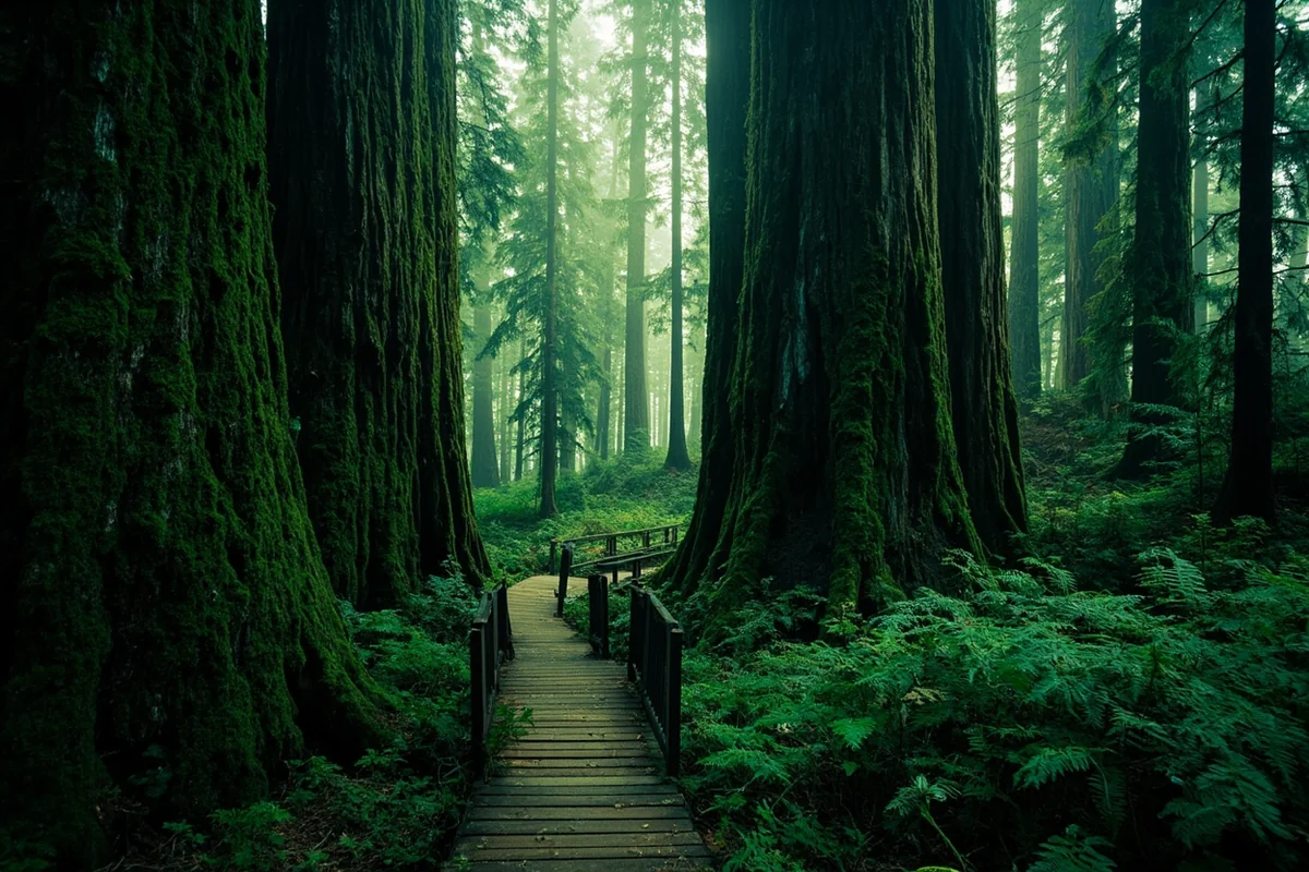
The first time I walked into the Ross Creek Cedar Grove, I stopped at the first large tree and put both hands on the bark. It was cool and damp, and the fibrous reddish surface felt almost soft — nothing like the rough ponderosa or lodgepole pine I’d been touching all season.
Above me, the canopy closed in a perfect dome of dark green. Around me, a dozen other cedars in the same scale, each one over 500 years old, some of them over 8 feet in diameter.
I’d driven three hours to see this grove. Standing in it, I thought: I should have come years ago.
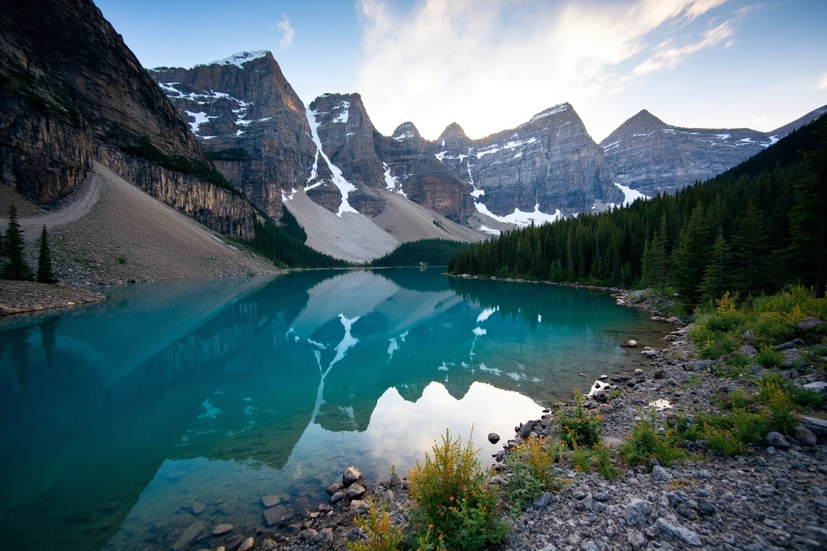
The Kootenai National Forest occupies Montana’s far northwestern corner — a small slice of the state bounded by Idaho to the south and west and Canada to the north — and it is unlike any other national forest in Montana.
Wetter, darker, more Pacific Northwest in character, the Kootenai is where you find ancient cedar groves, 15 species of conifers, and a sense of lush abundance that contrasts completely with the drier landscapes that most people associate with Montana.
- Kootenai National Forest covers 2.2 million acres in the far northwest corner of Montana and adjacent Idaho.
- Home to Ross Creek Cedar Grove (ancient cedars, some 500+ years old), Cabinet Mountains Wilderness, Ten Lakes Scenic Area, Lake Koocanusa (90 miles long), and the Yaak Valley.
- The wettest national forest in Montana — modified Pacific maritime climate supports 15 conifer species and extraordinary biodiversity.
- Gateway town: Libby (primary); Troy and Eureka for different sections.
- Outstanding for camping, boating, fishing, and hiking with minimal crowds.
Overview: Montana’s Most Biodiverse Forest
The Kootenai sits in Lincoln County — the far northwest corner of Montana — and extends into the northeast corner of Idaho. It is administered from Libby, Montana.
The climate here is fundamentally different from eastern Montana or even most of western Montana. Modified maritime air masses from the Pacific push far enough inland to give the Kootenai more precipitation than any other Montana national forest.
That moisture supports extraordinary ecological diversity: 15 species of conifers alone can be identified within the forest boundaries, along with a diverse understory of ferns, mosses, and deciduous shrubs that gives the forest floor a lushness you don’t find in drier forest types.
The Kootenai and Clark Fork Rivers both flow through the forest. The Kootenai River alone drops 800 feet in a dramatic gorge — the Kootenai Falls section is one of the most spectacular river features in northwest Montana.
Quick Stats:
| Category | Details |
|---|---|
| Total Acreage | ~2.2 million acres |
| Location | Lincoln County, NW Montana + NE Idaho |
| Wilderness | Cabinet Mountains Wilderness |
| Lakes | 100+ |
| Conifer Species | 15 |
| Campgrounds | 600+ basic sites (many free) |
| USFS Office | Libby — (406) 293-6211 |
| Annual Precipitation | Among highest in Montana |
Ross Creek Cedar Grove
This is the Kootenai’s signature attraction and one of the most extraordinary short walks in Montana.
The Ross Creek Cedar Grove Trail is a 1-mile loop through a stand of old-growth western red cedars that feel entirely out of place in the Montana imagination — until you understand that the Kootenai’s climate allows them to thrive here.
The trees range from impressive to genuinely astonishing. The largest individuals are over 500 years old, more than 175 feet tall, and 8 feet or more in diameter.
The boardwalk trail loops through the grove’s interior, and the interpretive signs give good context for the ecology. I recommend going on a gray or overcast day — the filtered light in the grove is dramatically beautiful, and the moisture in the air amplifies the cedar scent.
- Getting there: From Troy, drive about 4 miles south on Highway 56, then west on Bull Lake Road to the grove. The drive itself through the Bull Lake Valley is scenic.
- Distance: 1-mile loop
- Difficulty: Easy; mostly flat, partly boardwalk
- Fee: Free; no reservation required
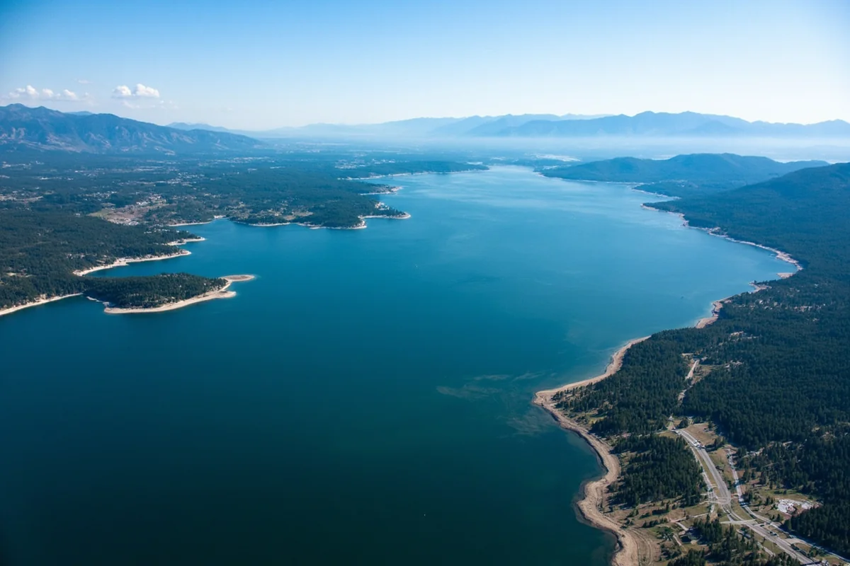
Lake Koocanusa
Lake Koocanusa is a reservoir created by Libby Dam on the Kootenai River, and at 90 miles in length — stretching from just north of Libby well into British Columbia, Canada — it is the longest reservoir in Montana and one of the longest in the western United States. The name combines Kootenai, Canada, and USA.
For visitors, Koocanusa is primarily a recreation lake: boating, fishing, camping, and swimming in the warmer sections near the south end.
The drive along the Koocanusa Scenic Byway (the road on the reservoir’s west side) is outstanding — wide water, forested hills, and mountain backdrops that change character every few miles.
Lake trout (mackinaw) are the primary fishing quarry in Koocanusa, pursued by deepwater trolling. The reservoir also holds kokanee salmon that attract both anglers and osprey in numbers. I watched osprey dive-fishing on Koocanusa on a July morning and counted 9 separate dives in under an hour.
Cabinet Mountains Wilderness
The Cabinet Mountains Wilderness encompasses 94,272 acres of steep, glacier-carved terrain within the Kootenai NF — a compact but rugged range with several peaks exceeding 8,000 feet and more than 30 alpine lakes scattered through its interior cirques.
The Cabinet Mountains are notable for two things beyond their scenic appeal: grizzly bears and wolverines.
The Cabinet-Yaak recovery zone is one of only two areas in the lower 48 where grizzly bears are being actively recovered (the other being the North Cascades).
The Cabinet Mountains support a small but genetically important grizzly population that wildlife biologists work to augment through translocation programs.
Wolverine habitat in the Cabinet Mountains is among the most significant in the Northern Rockies — the combination of deep mountain snowpack and remote terrain creates conditions this species requires.
Top Cabinet Mountains trails:
- Rock Lake Trail — 8 miles round-trip to a remote alpine lake; strenuous
- Leigh Lake Trail — 12 miles round-trip; dramatic cirque lake setting
- Cabinet Mountains via Copper Lake — 10 miles round-trip; best wildflower display in early July
Always carry bear spray in the Cabinets. This is active grizzly country with a small, vulnerable population — maintain extra care with food storage.
Ten Lakes Scenic Area
The Ten Lakes Scenic Area is a 15,000-acre roadless area in the northern Kootenai NF near the Canadian border — similar in concept to the Jewel Basin Hiking Area in the Flathead National Forest, though without the same level of visitation.
The name is accurate: there are at least ten named lakes in the area, ringed by ridgelines that provide easy cross-country travel once you’re above treeline.
The Highline Trail traverses the area’s main ridge with extensive views north into Canada and south into the Whitefish Range.
I did a two-day loop in the Ten Lakes Area in August and encountered exactly five other people — impressive given it’s within 90 minutes of Eureka and within a day’s drive of multiple population centers.
Access: From Eureka, take Grave Creek Road west to the various trailheads.
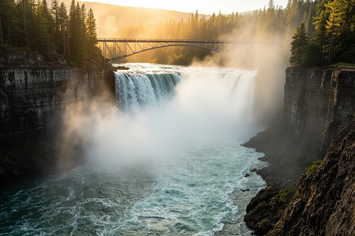
Kootenai Falls and the Kootenai River
Kootenai Falls is one of the most powerful waterfall systems in Montana — a series of rapids and drops on the Kootenai River just west of Libby where the river compresses through a basalt gorge.
A trail system from the parking area (off Highway 2 west of Libby) descends to viewpoints at river level, and a suspension bridge provides a dramatic crossing above the falls.
The Kootenai River holds some of the best white sturgeon habitat in the upper Columbia River system — a federally protected species that can reach 10 feet in length and over 100 years of age. Sturgeon fishing is catch-and-release only; check Montana FWP for current regulations.
The Yaak Valley
The Yaak Valley drains the remote northwestern corner of the Kootenai NF — a place so far into the forest that it sometimes functions as a world unto itself.
The Yaak River flows west through old-growth cedar and larch, eventually joining the Kootenai in Idaho, and the surrounding ridges support some of the densest wildlife habitat in the Northern Rockies.
The Yaak is probably best known among conservationists as a grizzly bear connectivity corridor — habitat linking the Cabinet-Yaak population with larger populations to the north — but for visitors, it’s primarily notable for its exceptional solitude and intact old-growth character.
We’ve given the Yaak Valley its own dedicated post: The Yaak Valley: Kootenai’s Wild Heart →
Camping in the Kootenai National Forest
The Kootenai has approximately 600 basic campsites throughout the forest, the majority of which are either free or low-cost primitive sites. This is one of the most accessible free camping destinations in Montana — miles of forest roads lead to simple sites along rivers, lakes, and creek drainages.
Selected developed campgrounds:
| Campground | Fee | Notes |
|---|---|---|
| Rexford Bench | ~$12/night | Koocanusa lakefront; boat launch |
| Mcgregor Lake | ~$12/night | Scenic lake; swimming; fishing |
| Big Creek | Free | Yaak River access; primitive |
| Bull Lake | ~$10/night | Bull Lake; good fishing; picnic areas |
| Peck Gulch | ~$10/night | Koocanusa reservoir access |
| Dorr Skeels | ~$12/night | Near Troy; river fishing access |
[Verify current fees at USFS Kootenai NF or Recreation.gov]
The Kootenai also maintains USFS rental cabins through Recreation.gov in the Yaak River drainage — atmospheric historic ranger stations available for overnight stays. [Verify current availability at Recreation.gov]
Fishing in the Kootenai National Forest
The Kootenai River is the primary fishery, holding westslope cutthroat trout and bull trout (federally listed as threatened — catch and release only) in the upper reaches, and trophy rainbow and lake trout in the lower river near the dam. Kootenai Falls itself is a significant fishing landmark.
Koocanusa holds lake trout and kokanee salmon — the kokanee fishing with light gear is excellent in spring before the lake warms.
Interior streams like the Yaak River, Vermilion River, and dozens of smaller tributaries hold native westslope cutthroat in their pristine upper reaches. Fishing these small streams requires a willingness to walk, but the fish are wild and the setting is remarkable.
Montana fishing license required. Bull trout are listed under the Endangered Species Act — all catch is catch-and-release only. [Verify current regulations at montanafwp.gov]
Wildlife in the Kootenai
The Kootenai’s wildlife community reflects its climate and old-growth character. It’s the most biodiverse national forest in Montana in terms of both flora and fauna.
Grizzly bears (Cabinet-Yaak population): One of only two grizzly recovery areas in the lower 48 outside of the Northern Continental Divide Ecosystem. The population is small but present and expanding slowly. Bear spray is essential everywhere in the backcountry.
Woodland caribou: Historically present in the northern Kootenai; their current status is uncertain. Historically occupied the Cabinet Mountains and Selkirk Ranges.
Fishers and martens: The old-growth forests support some of the healthiest fisher and American marten populations in Montana.
Bald and golden eagles: Common along the Kootenai and Koocanusa. I’ve watched bald eagles fishing the Kootenai River in mid-February when the river remains open below the dam — a dozen birds working the same stretch simultaneously.
Moose: The wetter drainages — particularly the Yaak and Vermilion River systems — hold moose in high densities relative to other Montana forests.
Winter Recreation
The Kootenai’s heavy snowpack and extensive groomed snowmobile trail system make it a significant winter recreation destination. The Pipe Creek and Fisher River snowmobile systems are among the more developed in northwest Montana — connecting in some areas with trail systems in the neighboring Lolo National Forest to the south.
Cross-country skiing on ungroomed forest roads is excellent throughout the forest, and the Lake Koocanusa area offers ice fishing once the reservoir freezes sufficiently — usually by late December, though ice thickness varies.
Practical Info
| Category | Details |
|---|---|
| General access | Free |
| Campground fees | Free–~$15/night [verify]; most basic sites free |
| Nearest airport | Glacier Park International (FCA), ~2.5 hours from Libby |
| Main gateway | Libby (primary); Troy; Eureka |
| USFS office | Libby — (406) 293-6211 |
| Cell service | Good in Libby; poor to absent in Yaak Valley and remote drainages |
| Bear spray | Essential; Cabinet-Yaak grizzly population is present |
What I Wish I Knew Before My First Kootenai Trip
Ross Creek Cedar Grove deserves more than 30 minutes. I see a lot of visitors do a quick loop and leave. Take the slow version — find a big tree, sit down near its roots for a while. The scale of these organisms only registers when you stop moving.
Koocanusa is a long lake on a winding road. What looks like a short distance on the map can be 45 minutes on the Koocanusa lakeshore road. Build in extra drive time.
The forest roads in the Yaak drain poorly. After rain, lower-gradient forest roads in the Yaak can become significantly muddy. A Subaru with adequate clearance is usually fine in good conditions; after heavy rain, 4WD is sometimes needed.
FAQs: Kootenai National Forest
Why is the Kootenai National Forest wetter than other Montana forests?
The Kootenai sits in Montana’s northwestern corner where modified Pacific maritime air masses can penetrate far enough inland to deliver more moisture than the rest of the state. The result is a climate more similar to northern Idaho than the rest of Montana, supporting 15 conifer species and old-growth cedar groves.
Is Ross Creek Cedar Grove worth the drive from Kalispell or Missoula?
Yes, absolutely — especially when combined with other Kootenai highlights like Kootenai Falls and Lake Koocanusa. From Kalispell, allow a full day. From Missoula, plan for a day trip or overnight.
Are there grizzly bears in the Kootenai National Forest?
Yes. The Cabinet-Yaak recovery area spans the Kootenai NF and adjacent lands in Idaho. It supports one of the few grizzly populations in the lower 48. Bear spray is required for all backcountry travel.
Is Lake Koocanusa good for motorized boating?
Yes — Koocanusa allows motorized boats on the entire length. Several boat launches are maintained by the USFS along both the west and east shores. Speed limits may apply in some areas near campgrounds.
Montana’s Wet, Wild, Unexpected Corner
Most Montana visitors never make it to Lincoln County. It’s a long drive from Missoula, longer still from Bozeman, and the Kootenai National Forest doesn’t have a national park next door drawing people through on their way to somewhere else. You come here on purpose, or you don’t come.
That self-selection is part of what makes the Kootenai special. The visitors who do arrive tend to be people who’ve done their homework — who know about the cedar grove before they leave home, who have reservations at a Koocanusa campground, who’ve read enough about the Cabinet Mountains to understand what kind of country they’re entering.
Those visitors tend to leave with the same reaction I had on my first trip: why didn’t I come sooner?
The Kootenai is the most ecologically distinct national forest in Montana, and it’s one of the most rewarding for anyone willing to make the drive to Montana’s far corner. Our Montana national forests guide puts it in context alongside the other six forests.
And if you’re making the trip to Libby, there’s more than enough in that town and the surrounding forest to fill three or four days easily.
Have questions about the Kootenai, the cedar grove, or the Yaak? Leave them in the comments — or save this post for your northwest Montana itinerary.
Explore the Full Montana National Forests Series
← Back to the Montana national forests guide
Also in this series: