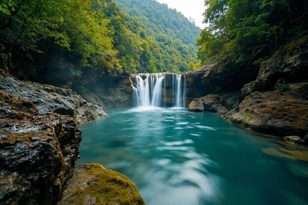
Standing at the base of Monture Falls last July, with ice-cold mist settling on my face and the roar of cascading water drowning out every other sound, I understood why some waterfalls remain beautifully undervisited—the journey to reach them filters out all but the most determined adventurers.
This isn’t a roadside attraction or a quick photo stop; Monture Falls demands effort, rewards patience, and delivers an authentic Montana wilderness experience that most Montana waterfalls simply can’t match.
- Monture Falls is located in the Bob Marshall Wilderness complex near Ovando, Montana
- Round-trip hike is approximately 12-14 miles depending on your route
- Best visited June through September when trails are clear and water flow is optimal
- No permits required for day hiking, but wilderness regulations apply
- Expect a full-day adventure with moderate difficulty and significant elevation gain
- Bears are active in this area—carry spray and know how to use it
- Cell service is nonexistent, so download offline maps before you go
What Makes Monture Falls Worth the Trek
I’ll be honest with you—Monture Falls isn’t going to show up on most tourist itineraries, and that’s precisely what makes it special.
Located in the southern portion of the Bob Marshall Wilderness complex, this waterfall represents everything I love about backcountry Montana: solitude, pristine wilderness, and the kind of natural beauty you have to earn.
During my visit last summer, I encountered exactly two other hikers the entire day. Compare that to the crowded trails at Morrell Falls just a few valleys over, where parking lots overflow by 9 AM during peak season.
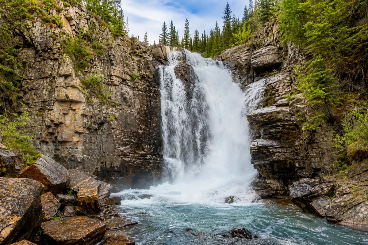
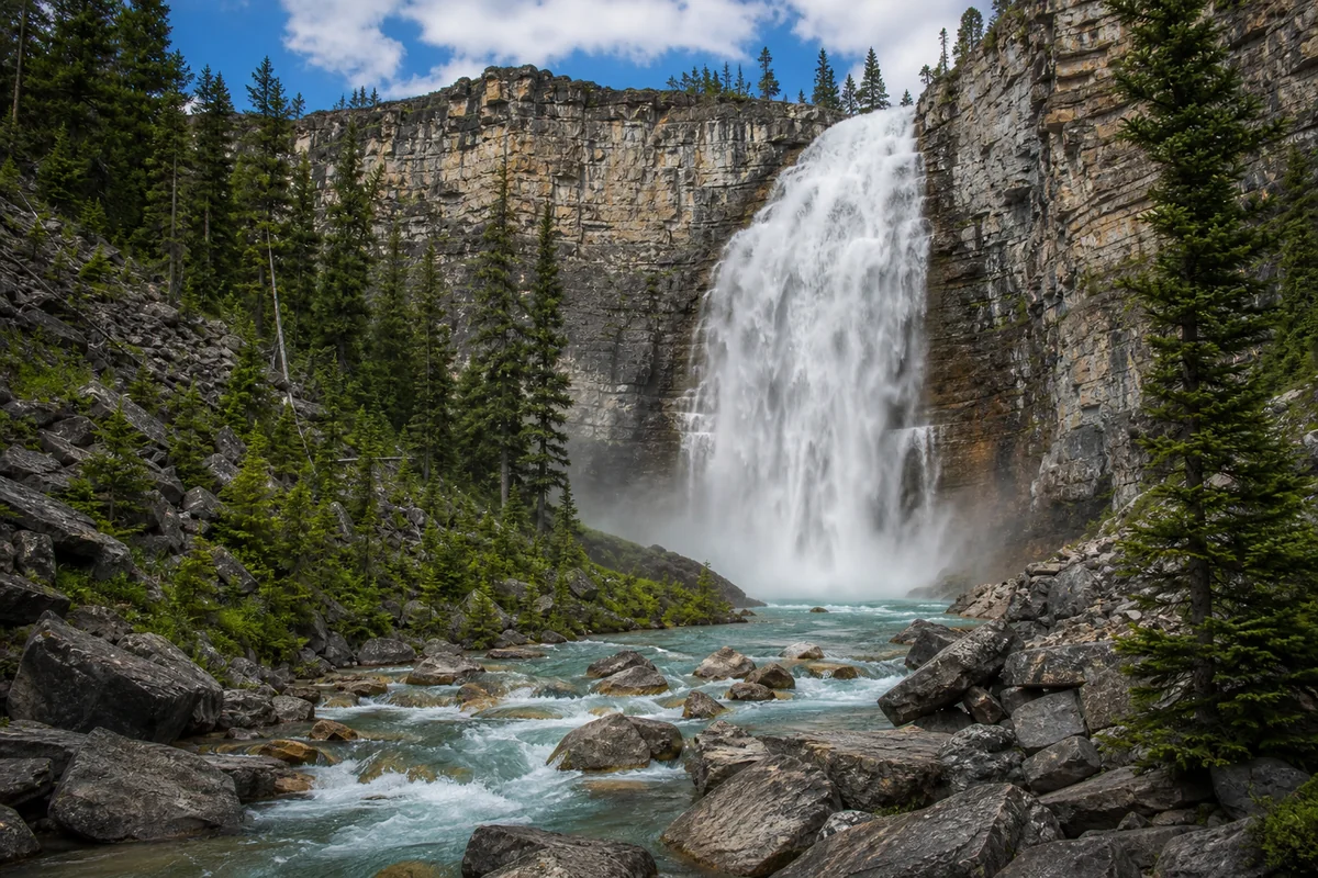
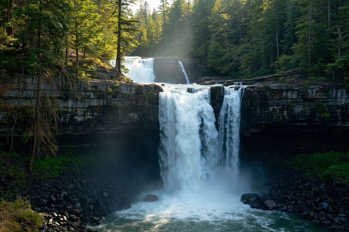
The falls themselves drop approximately 30-40 feet in a powerful cascade, fed by Monture Creek’s snowmelt-charged waters.
What photographs can’t capture is the thunderous sound that fills the narrow canyon, or the way late afternoon light filters through the surrounding old-growth forest creating an almost mystical atmosphere.
Understanding the Geography
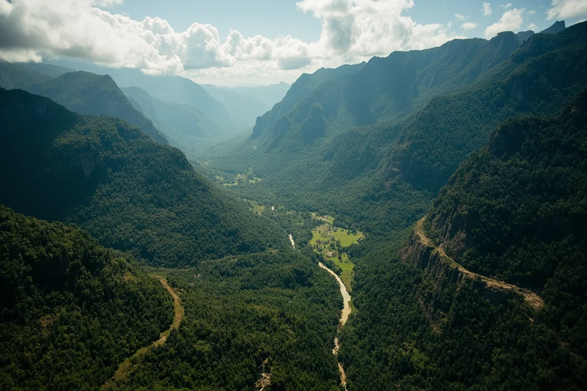
Monture Creek originates high in the Scapegoat Wilderness, flowing northward through some of the most rugged terrain in the Lower 48. The creek carves through a dramatic canyon before eventually joining the Blackfoot River near the small community of Ovando.
The waterfall sits at a point where the creek drops over a resistant rock ledge, creating a classic plunge-pool formation.
I noticed during my hike that the surrounding geology includes exposed sedimentary layers, hinting at the ancient seafloor origins of this landscape.
This area marks the transition zone between the more accessible foothills and the true wilderness beyond. Standing at Monture Falls, you’re literally on the doorstep of one of America’s largest wilderness areas—over 1.5 million acres of roadless terrain stretching north toward Glacier National Park.
Getting to the Trailhead
The primary access point for Monture Falls is via the Monture Creek Trail, which begins at the Monture Creek Trailhead located approximately 10 miles northeast of Ovando, Montana.
Driving Directions from Missoula
From Missoula, head east on Highway 200 toward Lincoln. After about 30 miles, turn left (north) onto Highway 83 at Clearwater Junction. Continue approximately 15 miles, then turn right onto Woodworth Road (Forest Road 7560).
The trailhead road is gravel but generally well-maintained. When I drove it in my Subaru Outback, I had no issues, though I’d recommend higher clearance vehicles earlier in the season when winter damage may not yet be repaired.
Driving Directions from Great Falls
Take Highway 89 south toward Helena, then west on Highway 200 to Lincoln. From Lincoln, continue west on Highway 200 to Clearwater Junction, then follow the directions above.
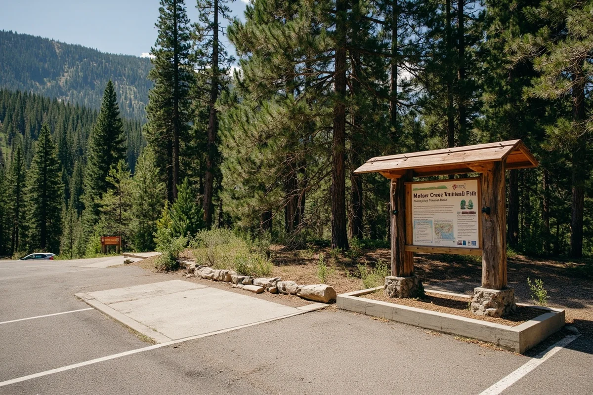
Trailhead Facilities
The Monture Creek Trailhead is rustic but functional. You’ll find a small parking area that accommodates maybe 10-12 vehicles, a pit toilet, and an information board with current trail conditions and bear activity reports.
There’s no potable water at the trailhead, so fill up before you arrive. I always carry at least three liters for a day hike of this length, plus a water filter for creek refills.
| Trailhead Information | Details |
|---|---|
| Coordinates | 47.0847° N, 113.1183° W |
| Elevation | Approximately 4,400 feet |
| Parking | Free, 10-12 vehicle capacity |
| Facilities | Pit toilet, information board |
| Cell Service | None—download offline maps |
The Hike to Monture Falls: What to Expect
The trail to Monture Falls follows Monture Creek upstream, gradually gaining elevation as it penetrates deeper into the wilderness. I’d classify this as a moderate-to-strenuous hike, not because of technical difficulty, but due to the overall distance and accumulated elevation gain.
Trail Breakdown by Section
Miles 0-2: The Easy Warm-Up
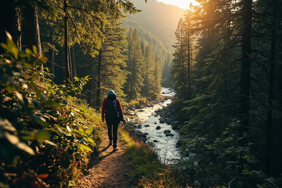
The first couple miles follow a well-established trail through mixed conifer forest. The grade is gentle here, perfect for finding your rhythm and warming up your legs. I noticed abundant wildflowers along this section during my July visit—lupine, Indian paintbrush, and beargrass were all putting on a show.
Monture Creek stays within earshot for most of this section, and there are several spots where you can access the water for filtering or cooling off tired feet.
Miles 2-4: Entering the Wilderness
Around the two-mile mark, you’ll officially enter the Bob Marshall Wilderness. There’s a boundary sign that makes for a decent photo opportunity. The trail begins climbing more noticeably here, with some switchbacks that help manage the elevation gain.
This section passes through older forest with larger trees and a more open understory. I spotted several deer browsing in the early morning and found fresh bear scat on the trail—a reminder to stay alert and make noise.
Miles 4-6: The Final Push
The last stretch to the falls involves the most significant climbing. The trail can become less defined in places, particularly where it crosses small tributary streams or traverses rocky sections.
When I hiked this in mid-July, there were still some snow patches on the north-facing slopes, though none blocking the trail. Earlier in the season, you might encounter more substantial snowpack.
The sound of the falls reaches you before you see them, building anticipation for the final reveal.
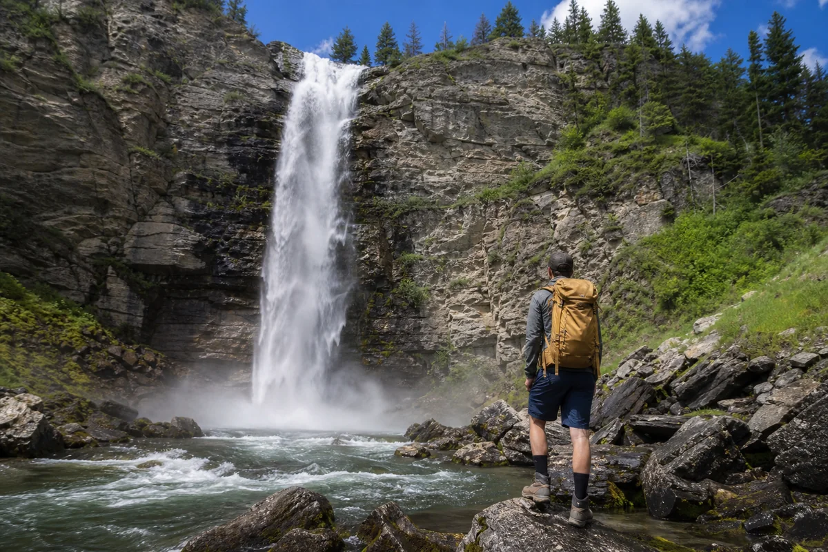
At the Falls: Making the Most of Your Visit
Arriving at Monture Falls, I immediately dropped my pack and just stood there for several minutes, letting the experience wash over me. After miles of hiking, the payoff is significant.
Viewing Points and Photography
The main viewing area sits across a rocky basin from the falls, providing a full-frontal perspective of the cascade. I found that mid-morning light worked best for photography, as afternoon sun creates harsh shadows on the west-facing falls.
For more adventurous photographers, scrambling along the creek’s edge gets you closer, but be extremely careful on wet rocks. I watched a fellow hiker slip and nearly go into the frigid pool below—it wouldn’t have been dangerous necessarily, but it would have made for a cold, wet hike back.
A wide-angle lens captures the full scene, but don’t neglect your telephoto—the details in the water patterns and the surrounding rock formations reward closer inspection.
Swimming and Water Access
Yes, there’s a swimmable pool at the base of the falls, but I want to be clear about what you’re getting into: this water is cold. Not refreshing-on-a-hot-day cold, but numb-your-limbs-in-thirty-seconds cold.
During my visit, I managed about 90 seconds of immersion before my body demanded I exit. If you’re planning to swim, I recommend bringing a quick-dry towel and changing into dry clothes immediately afterward.
The pool depth varies seasonally. In July, I found it about chest-deep in the center, with shallower areas near the edges suitable for wading.
Lunch Spots and Rest Areas
Several flat rocks near the falls make excellent spots for lunch. I claimed a sunny boulder about 50 yards downstream from the main pool, which offered a perfect view while being far enough away that the mist didn’t soak my food.
Plan to spend at least 45 minutes to an hour at the falls. You’ve earned this time, and the wilderness setting deserves more than a quick photo-and-go approach.
When to Visit Monture Falls
Timing your visit correctly can mean the difference between an exceptional experience and a frustrating one. Here’s what I’ve learned from multiple visits to this region.
Peak Season: June through September
June: Water flow is at its maximum as snowmelt peaks. The falls are at their most dramatic, but trails may still have snow patches at higher elevations, and creek crossings can be challenging. Mosquitoes are brutal—I’m talking clouds of them. DEET is mandatory.
July: My preferred month. Trails are fully clear, water flow remains strong, wildflowers peak, and insects begin to diminish. Days are long, giving you plenty of daylight for the extended hike.
August: Water levels drop noticeably by late August, though the falls remain impressive. Fewer bugs, stable weather, and the beginning of fall colors at higher elevations. This is arguably the most comfortable month for hiking.
September: Early September can be spectacular, with golden larches beginning their show. However, water flow is reduced, and afternoon weather becomes less predictable. Day length shortens, so start early.
Off-Season Considerations
I don’t recommend attempting Monture Falls from November through May for most hikers. Winter brings deep snow, avalanche danger in steep sections, and extremely short days. The trailhead road often remains unplowed into late spring.
If you’re experienced in winter backcountry travel, spring approaches on skis or snowshoes can be extraordinary, but this requires serious preparation and local knowledge.
Wildlife and Safety
This is grizzly country, and I don’t say that to be dramatic—I say it because it’s true and important. The Bob Marshall Wilderness supports one of the healthiest grizzly populations in the Lower 48.
Bear Safety Essentials
When I hike in this area, I carry bear spray, keep it accessible (hip holster, not buried in my pack), and make regular noise, especially when approaching blind corners or dense brush.
During my last visit, I found fresh bear digging along the trail where a grizzly had been excavating for roots. The claw marks in the soft earth were impressive—and humbling.
Travel in groups when possible. Talk, clap, or call out when moving through areas with limited visibility. Most bears want nothing to do with humans and will avoid you if given the chance.
If you encounter a bear, stay calm, don’t run, make yourself appear large, and back away slowly while speaking in a calm voice. If a grizzly charges, stand your ground—many charges are bluffs. If contact occurs, play dead for grizzlies (protect your neck and stomach), fight back aggressively for black bears.
Other Wildlife Encounters
Beyond bears, the Monture Creek drainage hosts mountain lions, wolves, moose, and elk. Moose can be particularly dangerous during fall rut or when cows have calves. Give them wide berth—they’re faster than they look and can be aggressive.
I’ve spotted wolves on two occasions in this general area, both times at distance. They’ve shown zero interest in approaching.
Stream Crossings and Water Safety
Depending on water levels, you may need to cross Monture Creek or its tributaries. Early season crossings can be thigh-deep and fast-moving. Trekking poles help immensely with balance, and I always unbuckle my pack’s waist belt before crossing deep water so I can shed it quickly if needed.
Water-resistant footwear or dedicated water shoes for crossings make a significant difference in comfort. Hiking the remaining miles in wet boots invites blisters.
What to Pack
For a day hike to Monture Falls, I recommend the following gear:
- Water: Minimum 3 liters, plus filtration system for refills
- Food: More than you think you need—the mileage burns calories
- Navigation: Downloaded offline maps (I use Gaia GPS), compass, paper map backup
- Bear spray: Non-negotiable in this wilderness
- Rain gear: Afternoon thunderstorms are common in summer
- Extra layers: Temperatures drop significantly in the forest and near the falls
- First aid kit: Including blister treatment
- Headlamp: In case your hike takes longer than planned
- Sun protection: Hat, sunscreen, sunglasses
- Trekking poles: Highly recommended for the mileage and creek crossings
- Emergency bivy or space blanket: Weight is minimal, peace of mind is significant
I also carry a satellite communicator (I use a Garmin InReach) for emergencies. There’s absolutely no cell service in this drainage, and rescue would take significant time to reach you.
Nearby Waterfalls and Alternative Hikes
If you’re making a waterfall-focused trip to this region, several other cascades are within reasonable driving distance.
Holland Lake Falls offers a much shorter hike with dramatic payoff, making it an excellent next-day recovery option after the Monture Falls trek.
For another backcountry experience, Morrell Falls near Seeley Lake provides a moderately challenging hike with a multi-tiered waterfall destination.
It’s more popular than Monture Falls, so expect company, but the falls themselves are spectacular.
If you’re interested in roadside cascades after your backcountry adventure, Kootenai Falls in northwestern Montana offers an entirely different experience—massive volume, easy access, and a stunning swinging bridge.
For those exploring the Glacier National Park region, Running Eagle Falls provides an accessible option with fascinating geological features, while Saint Mary Falls delivers classic park scenery with moderate hiking requirements.
Extending Your Trip: Backpacking Options
Monture Falls makes an excellent first-night destination for longer backcountry trips into the Bob Marshall Wilderness. The trail continues beyond the falls, eventually connecting with a network of paths that penetrate deep into some of America’s wildest country.
Multi-Day Itinerary Ideas
Option 1: Falls and Back (2 days)
Hike to the falls, camp near (but not too close to) the water, and return the following morning. This relaxed pace allows for photography in different lighting conditions and genuine immersion in the wilderness atmosphere.
Option 2: Monture to Meadows (3-4 days)
Continue beyond the falls toward Monture Meadows, where expansive alpine terrain opens up. This adds significant mileage and elevation gain but rewards with stunning high-country scenery.
Option 3: Bob Marshall Loop (7+ days)
Experienced backpackers can use Monture Creek as an entry point for extended traverses through the wilderness complex. These trips require serious planning, navigation skills, and self-sufficiency.
For backpacking trips, remember that fires are subject to wilderness regulations, and Leave No Trace principles are both required and essential for preserving this pristine environment.
Practical Logistics
Nearby Accommodations
The closest services are in Ovando, a tiny community with limited options. The Blackfoot Commercial Company offers cabin rentals and excellent baked goods—I’ve fueled many hikes with their morning pastries.
Seeley Lake, about 30 miles away, has more options including motels, vacation rentals, and full services. Lincoln, to the east, offers similar amenities.
For camping, several Forest Service campgrounds dot the Highway 83 corridor, including Seeley Lake Campground and various lakeside options. These fill quickly on summer weekends, so reserve ahead if possible.
Services and Supplies
Gas up before heading to the trailhead—the nearest reliable fuel is in Seeley Lake or Lincoln. I always carry an extra gallon in my vehicle when traveling these back roads.
Groceries are available in Seeley Lake at the Seeley Lake Mercantile or in Lincoln at several small stores. For major shopping, Missoula (about 60 miles from the trailhead) has everything you need.
Leave No Trace
I can’t stress this enough: pack out everything you pack in, and then some. I make a habit of collecting any trash I find along wilderness trails—unfortunately, even remote areas aren’t immune to litter.
Human waste should be buried in cat holes at least 200 feet from water sources. Better yet, pack out waste using WAG bags, especially in heavily used camping areas.
Stay on established trails to prevent erosion and protect fragile vegetation. The wilderness designation of this area exists because previous generations fought to preserve it—we owe it to future visitors to maintain that legacy.
My Honest Assessment
Is Monture Falls worth the significant effort required to reach it? For the right person, absolutely. For others, maybe not.
This hike suits you if you’re seeking genuine wilderness solitude, enjoy extended days on the trail, and value the journey as much as the destination.
The falls themselves are beautiful but not necessarily more spectacular than easier-to-reach options like Lost Creek Falls or Palisade Falls near Bozeman.
What you’re really paying for with those miles is the experience of being truly remote, of hearing nothing but wind and water and your own heartbeat, of standing somewhere that most people will never see.
If you’re looking for an impressive waterfall with minimal effort, check out Memorial Falls near Great Falls or Skalkaho Falls in the Sapphire Mountains. Both offer remarkable cascades with a fraction of the hiking required.
But if you’re drawn to wild places, if you find satisfaction in earning your views, and if you want to experience Montana the way it existed before roads and crowds and convenience—Monture Falls is calling.
Final Planning Checklist
Before you hit the trail, run through this checklist:
- Weather forecast checked for current day and overnight (if backpacking)
- Trailhead road conditions verified (Lolo National Forest website or ranger station call)
- Bear spray purchased and know how to use it
- Offline maps downloaded to phone and backup navigation ready
- Someone knows your hiking plan and expected return time
- Vehicle has full fuel tank and emergency supplies
- Physical conditioning appropriate for 12+ mile day with elevation gain
- Early start planned (I recommend 6-7 AM trailhead departure)
If you’re combining waterfall visits on your Montana trip, consider also exploring Grotto Falls for its unique geological setting or Hidden Falls for another less-traveled option. Each offers something distinctive, and variety makes any waterfall-hunting trip more rewarding.
For dramatic roadside falls that pair well with backcountry adventures, McDonald Falls in Glacier National Park requires virtually no hiking and showcases the power of glacial rivers in a way that complements quieter wilderness cascades.
Monture Falls won’t appear on Montana’s greatest hits list or attract Instagram crowds—and frankly, I hope it stays that way. Some places are better left to those willing to work for them, and this is one of them.
I’ll return next summer, probably in late July when the light is long and the mosquitoes have calmed down. Maybe I’ll see you on the trail. If I do, I’ll nod hello but keep my distance—in a place like this, solitude is part of the gift.
Frequently Asked Questions
How do I get to Monture Falls in Montana?
Monture Falls is located in the Lolo National Forest near Ovando, Montana. To reach the trailhead, take Highway 200 to Ovando, then head north on Monture Creek Road (Forest Road 89) for approximately 6 miles until you reach the Monture Creek Trailhead. The road is gravel but generally accessible for most vehicles during summer months.
How long is the hike to Monture Falls Montana?
The hike to Monture Falls is approximately 3 miles round trip along the Monture Creek Trail, making it a moderate half-day adventure. I found the trail relatively easy with gentle elevation gain, perfect for families and casual hikers. Plan for about 1.5 to 2 hours total hiking time to enjoy the scenery and take photos at the falls.
What is the best time of year to visit Monture Falls?
The best time to visit Monture Falls is late spring through early summer (May through July) when snowmelt creates the most impressive water flow. I recommend visiting in June for peak waterfall volume combined with accessible trail conditions. The falls are still beautiful in late summer and fall, though water flow decreases significantly by August.
Is Monture Falls trail dog-friendly?
Yes, Monture Falls trail is dog-friendly, and I’ve seen many hikers enjoying the path with their four-legged companions. Dogs should be kept on a leash to protect wildlife and other hikers in the Lolo National Forest. Bring plenty of water for your pup since the creek crossings can be unreliable depending on the season.
What should I bring for the Monture Falls hike?
Pack sturdy hiking boots with good ankle support since the trail can be muddy and has some rocky sections near the falls. I always bring bear spray (essential in Montana grizzly country), plenty of water, snacks, and layers since mountain weather changes quickly. A camera is a must for capturing the stunning 30-foot cascade and surrounding forest scenery.
Is there a fee to visit Monture Falls in Montana?
There is no entrance fee or parking fee to visit Monture Falls since it’s located on Lolo National Forest public land. You won’t need a recreation pass like some other Montana destinations require. This makes it one of the best free waterfall hikes in western Montana for budget-conscious travelers.
Can you camp near Monture Falls Montana?
Yes, there are dispersed camping options along Monture Creek Road and the established Monture Creek Campground nearby offers basic amenities. I’ve found great primitive camping spots within a few miles of the trailhead, though you’ll need to follow Leave No Trace principles on forest land. For those wanting more amenities, the small town of Ovando is about 10 miles away with limited lodging options.