Somewhere in the entire 8,000-mile trail Lewis and Clark blazed across half a continent, there’s exactly one spot where you can stand and see, with your own eyes, physical proof they were there. It’s not in a museum case. It’s not a replica. It’s a signature, carved into a sandstone cliff on the banks of the Yellowstone River, and I’ve stood in front of it enough times now that I still get a small jolt every visit.
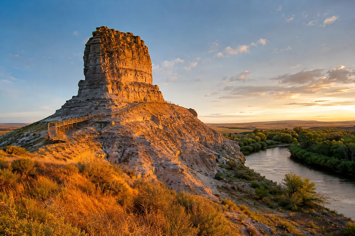
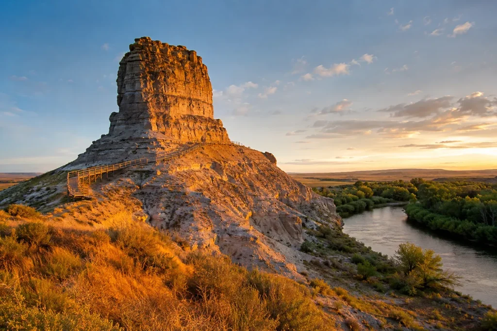
Pompeys Pillar National Monument sits 25 miles northeast of Billings off I-94, and it protects the only surviving on-site physical evidence of the entire Lewis and Clark Expedition — William Clark’s own signature, carved into the rock on July 25, 1806. The 120-to-150-foot sandstone butte (sources disagree, and I’ll explain why below) is climbable via a boardwalk with about 200 steps, the interpretive center is genuinely well done, and the whole visit takes under two hours. The gated season runs May through September with a small vehicle fee; outside those months you can walk in for free, dawn to dusk. This is one of the most underrated stops in Southeast Montana, and I’m always a little baffled that so few people make the 25-minute detour off the interstate to see it.
Why This Rock Matters More Than It Looks Like It Should
I’ll be honest — the first time a friend told me to detour off I-94 to see “a rock with an old signature on it,” I was skeptical. Eastern Montana has no shortage of scenic overlooks and roadside curiosities, and I wasn’t sure this one would earn the 25-minute drive from Billings.
It did. Easily.
Here’s what makes Pompeys Pillar different from every other Lewis and Clark site along the entire trail, from Pittsburgh to the mouth of the Columbia: it’s the only place where visible, physical evidence of the expedition still exists exactly where it was left.
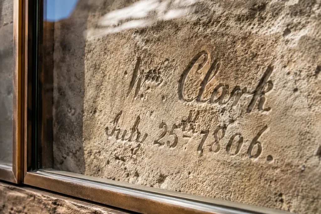
Not a marker. Not a monument built later to commemorate something that happened nearby. The actual signature, carved by William Clark’s own hand on July 25, 1806, still sits in the rock face, roughly where he left it.
Clark wasn’t traveling with Lewis when he made the carving. On the return journey in 1806, the two captains split their party at Travelers’ Rest near present-day Lolo — Lewis headed north to explore the Marias River country, while Clark took a separate detachment east to explore the Yellowstone River drainage.
Clark’s group included Sacagawea and her toddler son, Jean Baptiste Charbonneau, whom Clark had taken a real liking to during the expedition and nicknamed “Pomp.”
When Clark’s party reached this sandstone outcrop on the afternoon of July 25, he climbed it, admired the view, and carved his name and the date into the rock. He named the formation “Pompy’s Tower” after the little boy.
The name was changed to “Pompeys Pillar” in 1814, when Nicholas Biddle published the first official history of the expedition and apparently thought the revised name read better.
The Height Discrepancy Nobody Explains
If you research this place before visiting, you’ll notice something odd: sources can’t agree on how tall Pompeys Pillar actually is. I’ve seen it listed as 120 feet, 130 feet, and 150 feet across official government sites alone, and Clark’s own journal estimated 200 feet.
Here’s the likely explanation, as best I can piece together: Clark was eyeballing the height from below with no surveying equipment, on a hot July afternoon, after paddling all day — a 200-foot guess isn’t unreasonable under those conditions but it’s clearly an overestimate.
Modern measurements from the base to the summit land somewhere in the 120-to-150-foot range depending on exactly where you start measuring from (the surrounding bottomland isn’t perfectly flat, so “base” is a little fuzzy).
I’ve seen the most recent BLM visitor materials cite 120 feet, while other official sources still use 150. Don’t let the discrepancy bother you — either way, it’s a serious climb, and the view from the top is legitimately worth every step. [Verify current official height figure with BLM before publishing — sources conflict.]
What You’ll Actually Do When You Visit
Start at the Interpretive Center
The visitor center, completed in 2006, is a genuinely well-built 5,700-square-foot facility, and I’d recommend starting here before you walk out to the pillar itself.
The exhibits cover Clark’s 1806 journey down the Yellowstone, and there are original J.K. Ralston paintings on display depicting the expedition — Ralston was a respected Montana Western artist, and seeing his interpretations of the scene before you walk out to see the real rock adds context I didn’t expect to appreciate as much as I did.
Outside the center, there’s a replica tipi, replica dugout canoes (similar to the ones Clark’s party built to travel the Yellowstone), and a small homesteader’s cabin exhibit. Give this area 20–30 minutes before you head to the pillar itself.
Walk the Boardwalk to Clark’s Signature
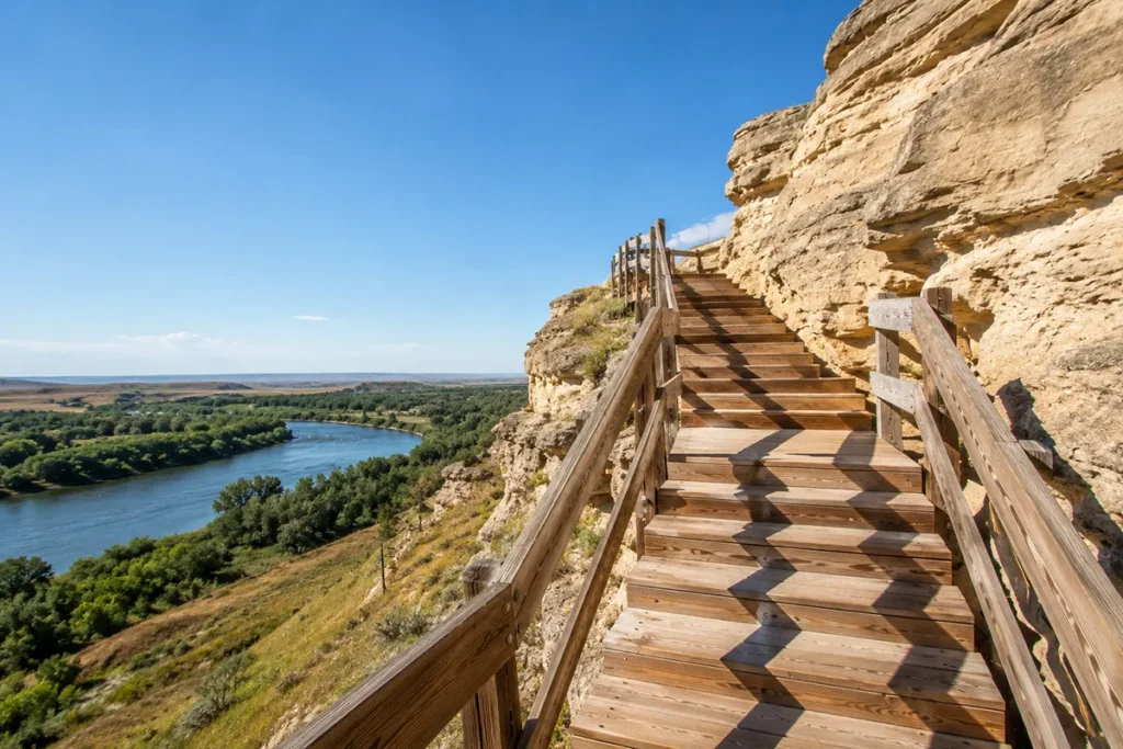
From the visitor center, a paved walkway leads out to the base of the pillar, then transitions into a wooden boardwalk that climbs partway up the formation — roughly 1,000 feet long with about 200 steps total.
The first 100 steps bring you to a landing right next to Clark’s signature, now protected behind a bronze-framed glass casement (it was re-carved and reinforced over the decades as the soft sandstone weathered — Clark’s original 1806 carving was reportedly still legible as late as 1876, but a century-plus of Montana wind and freeze-thaw cycles will wear down even solid rock).
Take your time at this landing. There’s usually an interpretive sign, and if a ranger or volunteer happens to be stationed there (common in peak summer), ask them questions.
Every time I’ve visited, whoever was posted at the signature turned out to be a genuine history enthusiast, not someone reciting a script.
Climb to the Top
The second half of the boardwalk — another roughly 100 steps — takes you to the summit. This is where Clark’s “extensive view in every direction” quote from his journal actually clicks into place.
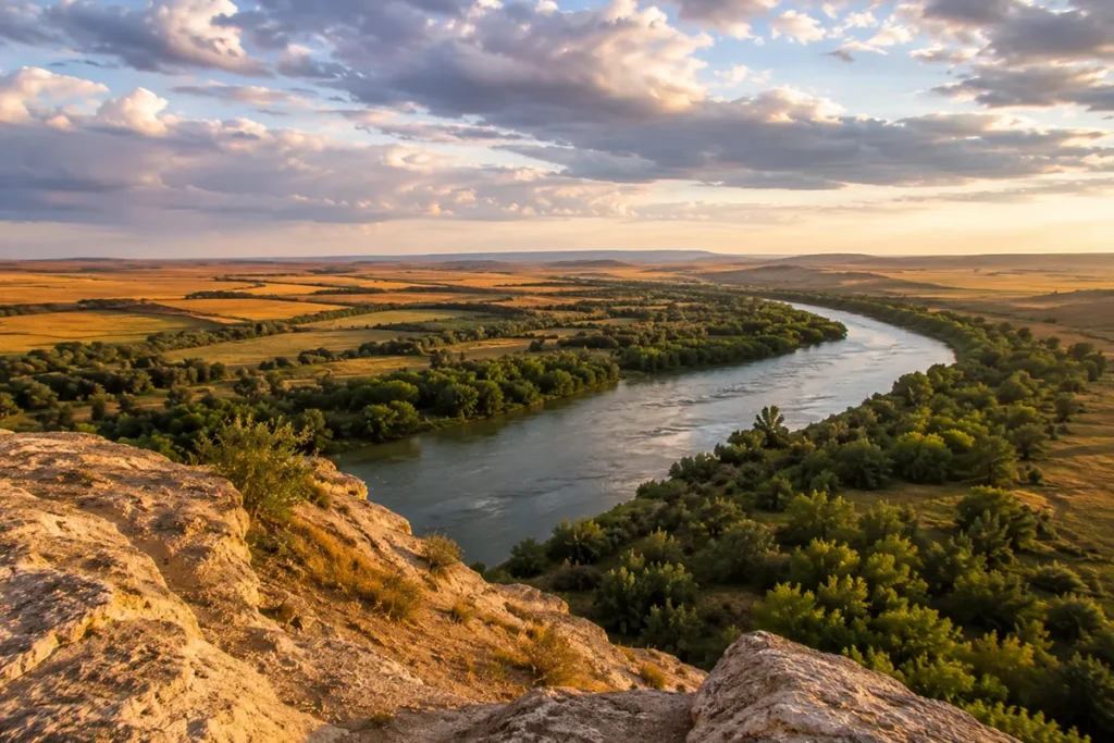
You can see the Yellowstone River curving below, the cottonwood bottomland, and flat prairie stretching to the horizon in every direction.
It’s not a dramatic mountain view — this is eastern Montana, after all — but there’s something clarifying about standing exactly where Clark stood and seeing almost exactly what he saw.
Look for the Other Carvings
Clark’s signature is famous, but it’s far from the only mark on this rock. Native peoples used Pompeys Pillar as a landmark and observation point for at least 11,000 years before Clark arrived, and the rock face carries centuries of carvings — animal figures, later fur trappers’ initials, steamboat crew signatures, army markings, homesteader graffiti.
Officially, it’s described as “hundreds” of additional markings, though some sources put the total number of etchings and petroglyphs in the thousands.
Either way, take a slower pass along the boardwalk and actually look at the rock face, not just the famous signature. There’s a genuinely layered human history carved into this thing.
A Detail Almost Nobody Mentions: Clark Wasn’t Actually First
Here’s a fact that gets buried in almost every account of this place, and I think it deserves more attention. Clark wasn’t the first European to document this rock.
A French-Canadian fur trader named François Antoine Larocque passed through and recorded the outcropping in 1805 — a full year before Clark’s famous visit. Larocque doesn’t get a signature carved into the rock or a national monument named in his honor, but he beat Clark here by twelve months.
I like this detail because it’s a small, honest correction to the “first white man to see it” framing that a lot of casual write-ups lean on.
The truth of Western exploration is almost always more layered than the single-hero version — fur traders, Indigenous peoples, and earlier expeditions were often moving through the same country long before the names we remember got there.
The Geology, Briefly
Pompeys Pillar is made of sandstone belonging to the Hell Creek Formation — the same late Cretaceous rock layer, roughly 75 to 66 million years old, that runs across much of eastern Montana and has produced some of the richest dinosaur fossil discoveries on Earth (Hell Creek is the source formation for the first Tyrannosaurus rex specimens ever found, over in the Missouri River Country region to the northeast).
The pillar itself formed as the Yellowstone River gradually cut its valley deeper over millions of years, leaving this particular sandstone outcrop standing above the surrounding floodplain as one of the only rock formations of its kind for miles along this stretch of river — which is exactly why it was such a useful landmark for so many centuries of travelers before Clark ever showed up.
Personal Tips / What I Wish I Knew
Go in the morning if you’re visiting in summer. Eastern Montana heat builds fast in July and August, and there’s very little shade on the boardwalk itself. I made the mistake of arriving at 1pm on an August visit and regretted it by the time I reached the top.
The interpretive center closes for winter, but the grounds don’t fully shut down. During the gated season (roughly May through September) there’s a vehicle fee and set hours. Outside that window, you can still walk in for free from dawn to dusk, though the visitor center and boardwalk access may be limited — call ahead if you’re planning an off-season visit. [Verify current off-season boardwalk access policy before publishing.]
It’s not an NPS site, but it still has a passport stamp. Pompeys Pillar is managed by the BLM, not the National Park Service, so it won’t count toward an NPS “unit counter” checklist if that’s a hobby of yours. That said, I’ve read that the site does have its own cancellation stamp for visitors who collect them — worth checking at the visitor center desk. [Verify current stamp availability.]
Bring water, even for a short visit. There’s essentially no shade once you’re on the boardwalk, and the round trip with photo stops at the top easily runs 45 minutes to an hour.
Combine it with Little Bighorn Battlefield. The battlefield is roughly an hour’s drive south, and the two sites pair well as a single day out of Billings — one covers the earliest recorded European contact with this stretch of the Yellowstone corridor, the other covers one of the most consequential events in the same region seven decades later.
Don’t trust GPS shortcuts from the south. If you’re approaching from that direction, some mapping apps try to route you off the highway onto unpaved back roads that aren’t actually faster and are harder on a standard vehicle. Stick to Exit 23 off I-94 or Highway 312.
The nearby town of Worden has the closest gas, ATM, and restrooms if you need them before or after your visit — there’s nothing at the monument itself beyond the visitor center facilities.
Practical Info Box: Pompeys Pillar at a Glance
| Item | Details |
|---|---|
| Location | 25 miles northeast of Billings, off I-94 Exit 23, or MT Highway 312 |
| Managing agency | Bureau of Land Management (BLM), with Friends of Pompeys Pillar nonprofit support |
| National Monument designated | January 17, 2001 |
| National Historic Landmark designated | 1965 |
| 2026 gated season | May 1 – September 30, 2026; closed Tuesdays for maintenance |
| Gate hours | 8:00am – 4:00pm during gated season |
| Entrance fee | Roughly $7/vehicle during gated season [verify current 2026 fee]; America the Beautiful passes accepted; free walk-in access dawn to dusk outside gated season |
| Time needed | 45 minutes to 2 hours |
| Boardwalk | ~1,000 feet, ~200 steps total; not wheelchair accessible to the summit, though the visitor center and grounds are ADA-compliant |
| Best season to visit | May through September (matches gated hours); go early to beat summer heat |
| Nearby amenities | Worden, MT (gas, ATM, restrooms) |
| Nearby attractions | Little Bighorn Battlefield (~1 hour south), Billings (~25–30 min west) |
| Pets | Leashed pets allowed on grounds; not permitted in visitor center or on the boardwalk |
Should You Make the Detour?
If you’re driving I-94 anywhere near Billings, yes — without hesitation. This isn’t a destination that needs a full day or a special trip of its own; it’s a 90-minute detour that connects you, in a very literal and physical way, to one of the most consequential journeys in American history.
I’ve brought out-of-state friends here who expected a quick photo stop and ended up spending an hour reading every interpretive panel.
There’s something quietly powerful about a place that doesn’t try to dramatize its own significance. Pompeys Pillar just sits there on the riverbank, the way it has for millions of years, holding a signature that’s been through more than two centuries of Montana weather and somehow survived anyway.
Save this guide for your next Southeast Montana trip, or pin it if you’re planning a Billings-based road trip. Got a question about visiting? Drop it in the comments — I answer every one.
➡️ Pairs well with: Little Bighorn Battlefield | Southeast Montana region guide | Billings