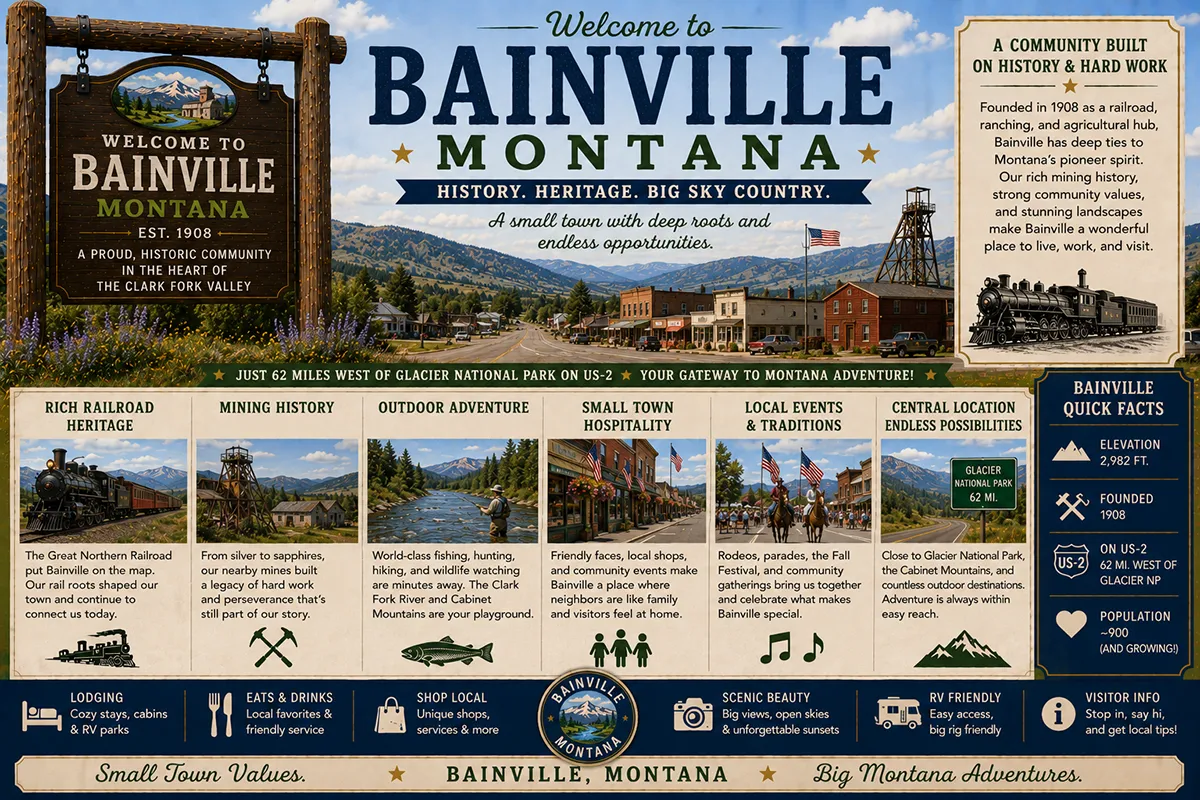
If you’re driving west across the top of Montana on US Highway 2, Bainville is the first town of any size you’ll encounter once you cross the North Dakota border.
It’s about five miles in. Population is around 150. The town sits directly on BNSF’s Great Northern Corridor — the mainline that runs from Chicago to Seattle and carries the Amtrak Empire Builder and an average of 40 freight trains a day.
The original Great Northern Railway depot is gone now, demolished some years back, but the broad railyard and grain elevators along the tracks make Bainville’s purpose obvious from the highway.
What makes Bainville unusual isn’t the size. It’s the position.
Bainville sits at the junction of two railroads. The BNSF mainline continues east-west through town. But here, the Scobey Subdivision branches off north — a spur the Great Northern built around 1910 specifically to compete with the Soo Line’s push into northeastern Montana.
The Scobey sub runs from Bainville north through Reserve, Homestead, Plentywood, Scobey, and ultimately to Opheim near the Canadian border. The Sidney Subdivision branches off south at nearby Snowden, running down through Sidney and into the heart of eastern Montana’s agricultural country.
For decades, those branch lines were quiet. Then the Bakken oil boom hit in the early 2010s, and Bainville got hit fast and hard.
Oil, pipe, and frac sand facilities sprouted along the rail corridor. BNSF took back the Scobey and Sidney subdivisions from leasing operator Watco in 2013 to handle the explosive freight traffic.
The sand distribution facility at Bainville — supporting Williston Basin oil drilling operations across the border — became one of the most important industrial facilities in northeast Montana.
The boom has subsided since its peak, but Bainville remains a working community shaped by two industries that have defined it since 1908: railroads and the resources they move.
TL;DR
- Bainville (~150) is in Roosevelt County on US-2, 5 miles from the North Dakota border and 25 miles east of Culbertson.
- The town sits on the BNSF Great Northern Corridor mainline at the junction with the historic Scobey Subdivision spur line (running north to Plentywood, Scobey, and Opheim).
- Established as a Great Northern Railway depot stop in the early 1900s; the original depot is now gone.
- Bakken oil boom transformed the community in the early 2010s — oil, pipe, and frac sand facilities still active.
- Approximately 40+ trains per day pass through Bainville on the BNSF mainline.
- Best for: Hi-Line travelers heading west into Montana, railroad heritage explorers, US-2 corridor stops, and Bakken oil patch context.
Bainville at a Glance
| Population (estimated) | ~150 |
|---|---|
| County | Roosevelt County |
| Region | Far Northeast Montana (Hi-Line) |
| Elevation | 1,910 ft |
| Distance to North Dakota border | ~5 miles east |
| Distance to Williston, ND | ~25 miles east |
| Distance to Culbertson | ~25 miles west on US-2 |
| Distance to Wolf Point | ~70 miles west |
| Distance to Sidney | ~70 miles south via MT-16 |
| Distance to Fort Peck | ~100 miles west |
| Best for | Hi-Line stops, railroad heritage, Bakken oil patch context |
What Makes Bainville Different
Three things define contemporary Bainville: the railroad junction, the border position, and the Bakken oil patch.
The Great Northern Railway built the original mainline through what’s now northeastern Montana between 1885 and 1893, finishing its push to Seattle and Tacoma under James J. Hill’s leadership.
Bainville was one of dozens of small division and water stops established along the line. The town developed in the standard Great Northern town pattern — grain elevators at the rail siding, a small commercial Main Street parallel to the tracks, and surrounding wheat and ranching country.
The Great Northern’s strategic decision to build the Scobey Subdivision north from Bainville around 1910 was a response to the Canadian Pacific-owned Soo Line pushing into northeastern Montana from the east.
The two railroads were essentially racing to claim the wheat country of Daniels, Sheridan, and Roosevelt counties for their respective freight networks. The Scobey sub ran from Bainville north through Plentywood to Scobey, eventually extending to Opheim near the international border.
That branch line operated relatively quietly through most of the 20th century. Then the Bakken changed everything.
The Bakken Boom
The Williston Basin oil and gas play — centered in western North Dakota but extending into far eastern Montana — exploded in the early 2010s with horizontal drilling and hydraulic fracturing technology.
Williston, North Dakota, 25 miles east of Bainville, became the boom’s epicenter. The population of Williston nearly doubled in five years.
Man camps housed thousands of itinerant workers. Trucks moved continuously on US-2 and the surrounding county roads.
Frac sand — used as a “proppant” in the fracking process — became enormous freight cargo, moved by rail from sand mines in Wisconsin and Minnesota to the Bakken patch.
Bainville’s rail position made it strategically important. The frac sand distribution facility built at Bainville handled the sand transfer from rail to truck for delivery to drilling sites across the border.
BNSF reclaimed the Scobey and Sidney subdivisions from leasing operator Watco in 2013 specifically to handle the explosive freight demand.
The boom peaked around 2014-2015 and has since moderated. International oil prices, market consolidation, and operational efficiency have all reduced the labor and infrastructure footprint.
But the underlying infrastructure remains. The sand facility still operates. Trains still pass through. Bainville is still on the front line of Montana’s oil and gas industry.
For broader trip context, see my Montana cities and towns hub and Montana railroads overview.
The Top 6 Things to Do In & Around Bainville
1. BNSF Mainline Railfanning
The Great Northern Corridor through Bainville is one of the most heavily-trafficked freight corridors in North America. Westbound traffic includes grain trains and Bakken crude oil. Eastbound carries goods from West Coast ports headed for the Midwest.
The Amtrak Empire Builder passes through twice daily but doesn’t stop. Railfans willing to spend time along the tracks (safely, from designated public locations only) can document a remarkable volume of train activity.
See my Montana railroads guide for broader rail context.
2. Hi-Line Cross-State Drive
US Highway 2 — the “Hi-Line” — is one of America’s classic cross-state drives. Bainville is the eastern starting point in Montana. From here, US-2 runs west through Roosevelt County, the Fort Peck Indian Reservation, Wolf Point, Glasgow, Malta, Havre, Shelby, Cut Bank, Browning, and ultimately to West Glacier and the Glacier National Park corridor.
A genuine end-to-end Hi-Line drive is a major Montana road-trip undertaking.
3. North Dakota Border Crossing
The border is 5 miles east. Williston, North Dakota — the heart of the Bakken boom — is 25 miles east. For travelers tracking US-Canada border crossings or seeking to understand the regional oil patch firsthand, the short detour into North Dakota provides direct context.
4. Fairview & Lower Yellowstone Day Trip
Fairview — the small community at the tip of the Lower Yellowstone Valley about 30 miles southeast — offers Lower Yellowstone Irrigation Project heritage, the historic Hotel Albert, and the regional agricultural story. A worthwhile day trip from Bainville.
5. Bainville-Snowden Road / MT-347 Drive
The road southeast from Bainville toward Snowden follows the BNSF Sidney Subdivision along the Missouri River corridor. A genuine working-rail country drive past grain elevators, ranchland, and the Missouri River valley.
6. Day Trip to Culbertson (25 miles west)
The slightly larger Hi-Line community to the west — Culbertson Museum, the Big Sky Country National Heritage Area visitor information, additional restaurants, and the gateway to the broader Roosevelt County and Fort Peck Indian Reservation country.
Where to Stay
Bainville has very limited lodging. Most travelers either continue west to Culbertson or Wolf Point, or east into Williston, North Dakota.
| Lodging | Vibe | Price | Best For |
|---|---|---|---|
| Vacation rentals (Bainville/Williston area) | Limited options | $130–250 | Boom-era workers, families |
| Culbertson motels (25 min W) | Basic Hi-Line lodging | $90–150 | Most travelers |
| Williston, ND hotels (25 min E) | Full selection from Bakken era | $130–280 | Larger town comforts |
| Wolf Point lodging (70 min W) | Roosevelt County seat | $100–180 | West-bound travelers |
Where to Eat
Bainville has very limited dining. Options expand significantly in Culbertson or across the border in Williston.
- Local Bainville options — small cafes and a tavern; verify current operations
- Culbertson restaurants (25 min W) — Hi-Line dining variety
- Williston, ND (25 min E) — full Bakken-era restaurant selection
Getting There & Around
From Culbertson: 25 miles east on US-2, about 30 minutes.
From Wolf Point: 70 miles east on US-2, about 1.25 hours.
From Williston, ND: 25 miles west on US-2, about 30 minutes.
From Sidney: 70 miles north via MT-16, about 1.25 hours.
Cell service: Generally available in Bainville and along US-2. Limited in the surrounding ranchland.
When to Visit
Summer (June–August): Best Hi-Line driving conditions; longest daylight; warmest weather; freight rail traffic at peak.
Fall (September–October): Harvest season — peak grain elevator activity; outstanding sky color over the prairie.
Winter (December–March): Severe weather possible; the Hi-Line is genuinely cold in deep winter (-30°F not uncommon); travel only with proper preparation.
Spring (April–May): Quiet shoulder season; the prairie greens up; some businesses on limited schedules.
Personal Tips
This isn’t a tourist town. Bainville is a working community. Plan accordingly. The interesting things are the railroad operations, the Bakken context, and the cross-state Hi-Line drive — not curated visitor attractions.
Use Bainville as a Hi-Line starting point. For travelers planning to drive US-2 across all of Montana, starting at Bainville on the North Dakota border and finishing at West Glacier or beyond is a legitimate multi-day road trip with genuine character.
Combine with the Bakken oil patch. Travelers interested in understanding the contemporary American oil and gas industry can productively combine a Bainville visit with a trip into Williston, ND, and the surrounding drilling country.
Photograph trains safely. The 40+ daily freight movements and the Empire Builder passenger passages make the corridor genuinely substantive railfan territory. Never trespass on tracks. Stay in designated public locations. Be aware that uncontrolled rail crossings in the area have been the site of multiple fatal incidents over the past decade.
Fuel up. Services drop off significantly between Bainville and Wolf Point — 70 miles of mostly open prairie. Fill up at Bainville or Culbertson before heading west.
Bainville Quick Facts
| Position | First Roosevelt County town west of ND border on US-2 | | Great Northern Railway established | Mainline completed through area 1885-1893 | | Scobey Subdivision built | ~1910 (to counter Soo Line expansion) | | Bakken boom impact | Early 2010s (peak ~2014-2015) | | BNSF reclaimed Scobey/Sidney subs from Watco | 2013 | | Average daily freight trains | 40+ | | Distance to ND border | ~5 miles | | Average summer high | 84°F | | Average winter low | -8°F |
Conclusion
Bainville is a working Hi-Line town with a specific industrial purpose.
The railroad junction, the Bakken oil patch, and the position 5 miles from the North Dakota border define what’s here. For travelers interested in contemporary Montana economic geography — particularly the intersection of historic railroads with 21st-century oil and gas — Bainville is a substantively interesting stop. For travelers expecting curated tourism, it isn’t.
The next time you’re heading west on US-2 from North Dakota, Bainville is your entry to Montana. Don’t blow past without understanding what you’re seeing.
Have a Bainville question? Drop it in the comments — I read every one.
Frequently Asked Questions
Is Bainville Montana worth visiting?
Bainville is worth a stop for travelers interested in railroad heritage (the town sits on BNSF’s Great Northern Corridor mainline at the junction with the historic Scobey Subdivision), the Bakken oil patch context (Bainville is the closest substantial Montana community to the Williston Basin boom), and as the eastern starting point for the US-2 Hi-Line cross-state drive. It is not a tourism destination in the traditional sense.
Where is Bainville Montana?
Bainville is in Roosevelt County in far northeastern Montana, on US Highway 2 (the “Hi-Line”) approximately 5 miles west of the North Dakota border. It is the first town of significance you encounter when entering Montana on US-2 from North Dakota. Williston, North Dakota is 25 miles east; Culbertson is 25 miles west.
What is the Bakken oil boom?
The Bakken oil boom refers to the rapid expansion of oil and natural gas drilling in the Williston Basin of western North Dakota and far eastern Montana, beginning in the late 2000s and peaking around 2014-2015. Horizontal drilling combined with hydraulic fracturing made previously inaccessible oil reserves economically recoverable. The boom transformed the regional economy, dramatically increased rail freight traffic on the BNSF Great Northern Corridor, and brought substantial industrial development to Bainville (including a major frac sand distribution facility). The boom has since moderated but underlying infrastructure remains active.
How big is Bainville Montana?
Bainville has approximately 150 year-round residents (some estimates run slightly higher; the population fluctuated during the Bakken oil boom). The community covers a small area along US-2 and the BNSF Great Northern Corridor mainline.
How far is Bainville from Williston North Dakota?
Bainville is approximately 25 miles west of Williston, North Dakota, on US Highway 2 — about a 30-minute drive. The North Dakota state line is approximately 5 miles east of Bainville.
What is the Scobey Subdivision?
The Scobey Subdivision is a BNSF (formerly Great Northern Railway) rail line that branches off the Great Northern Corridor mainline at Bainville and runs north through Plentywood, Scobey, and ultimately to Opheim near the Canadian border. The Great Northern built the subdivision around 1910 specifically to compete with the Canadian Pacific-owned Soo Line, which was pushing into northeastern Montana from the east. The subdivision is now primarily a freight corridor for grain and Bakken oil patch traffic; BNSF reclaimed operational control from leasing operator Watco in 2013.