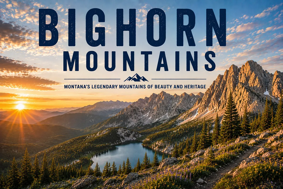
Let me say this clearly up front, because most websites won’t: the Bighorn Mountains are predominantly a Wyoming range, not a Montana one.
About 95 percent of the range — including all of Cloud Peak, the Cloud Peak Wilderness, the entire Bighorn Scenic Byway, and the Medicine Wheel — sits south of the state line. The Montana portion is a small northern toe in Big Horn County around Decker.
If you flew into Billings expecting to hike the Bighorns from a Montana base, you have a 90-minute to two-hour drive south to get there.
This post does two things. First, it tells you honestly what is in Montana when you say “Bighorn Mountains.” Second, it gives you the real planning information for the broader Wyoming Bighorns, because the Montana-Wyoming border doesn’t actually stop the mountains and a serious Bighorns trip is well worth the drive.
The Bighorn Mountains run about 150–200 miles through north-central Wyoming, with only a small northern foothill area crossing into Big Horn County, Montana near Decker. The high point is Cloud Peak (13,167 ft) in Wyoming — accessed via the Cloud Peak Wilderness (189,000 acres, all in Wyoming). The Montana-accessible experience is best understood as a combination of Bighorn Canyon National Recreation Area (which straddles the state line and contains Yellowtail Dam and Bighorn Lake), the Tongue River drainage near Decker, and an easy drive south into Wyoming for the serious mountain content. The bedrock is 3.25-billion-year-old Archean rock — some of the oldest exposed on Earth.
The Wyoming-Montana Geography You Need to Understand
The Bighorn Mountains are a roughly 150–200-mile-long range running north–south through north-central Wyoming. They rise abruptly from the Powder River Basin on the east and the Bighorn Basin on the west, with Cloud Peak (13,167 ft) as the high point.
The Bighorn National Forest covers approximately 1.12 million acres — all of it in Wyoming. The Cloud Peak Wilderness Area (189,000 acres) — all in Wyoming. The Bighorn Scenic Byway, the Cloud Peak Skyway, and the Medicine Wheel National Historic Landmark — all in Wyoming.
The northern extremity of the range crosses into Big Horn County, Montana as a series of lower foothills around the unincorporated community of Decker along the Tongue River.
The Montana portion sits at elevations of roughly 3,500 to 5,000 feet — these are the foothills of the range, not the alpine country. There are no major peaks, no wilderness areas, and no significant trail systems on the Montana side.
This is a frustrating travel-planning fact. Most major mountain ranges respect state lines reasonably. The Beartooths cross between Montana and Wyoming with significant high country on both sides.
The Bitterroots split Montana and Idaho roughly evenly. The Bighorns just don’t — Wyoming got the mountains.
That said: from a traveler’s perspective, the Bighorns are very much within Montana’s orbit. Sheridan, Wyoming — the main gateway town for the eastern side of the range — is about 90 minutes by car from Billings, Montana.
The drive from anywhere in southeast Montana into the Wyoming Bighorns is easy and direct. If you’re already in Montana and you want a Bighorns experience, the Wyoming portion is well within reach.
For broader context on how the Bighorns relate to Montana’s other ranges, see my full Montana mountain ranges guide.
What’s Actually in Montana
Let’s cover what you can experience without crossing into Wyoming.
Big Horn County and the Decker Area
Decker is an unincorporated community in southeast Big Horn County along the Tongue River, at the foot of the Bighorn foothills. Elevation about 3,500 feet.
There’s not much in town — a small cluster of residences, some coal mining infrastructure (this is part of the Powder River Basin coal country), and the Tongue River winding through.
The country around Decker has rolling, sparsely forested hills with pine-dotted rimrock and prairie. It’s pretty in a quiet, austere way — but it’s not the alpine Bighorns experience most travelers are looking for.
Bighorn Canyon National Recreation Area
This is the real Montana-accessible experience associated with the Bighorn Mountains.
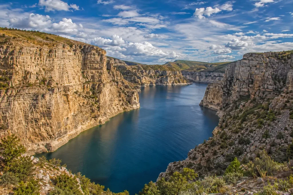
Bighorn Canyon National Recreation Area is a 120,000-acre unit of the National Park System straddling the Montana–Wyoming border, with significant land area in both states.
The NRA was created when Yellowtail Dam was completed in 1966, impounding the Bighorn River to form Bighorn Lake — a 71-mile-long reservoir running south through a spectacular limestone canyon.
The Montana portion of the NRA is in Big Horn County southwest of Hardin, and the access points include:
- Yellowtail Visitor Center (Fort Smith, MT) — interpretation of the dam, the river, and the Crow Tribe whose land surrounds the area
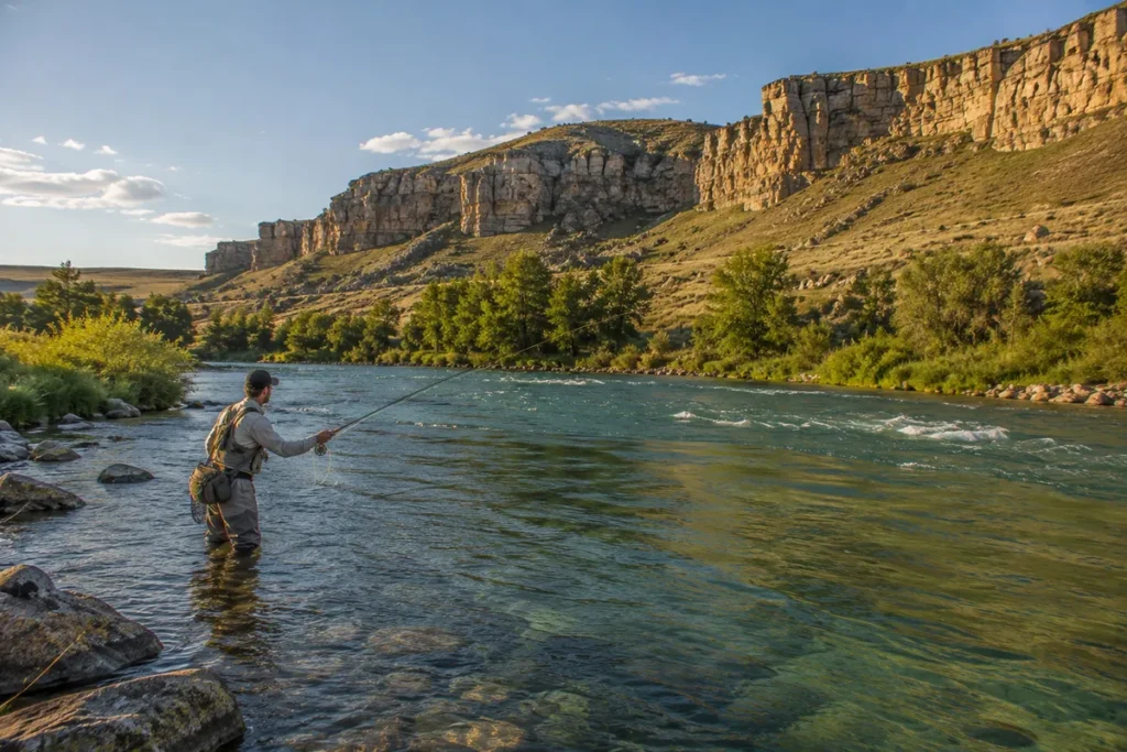
- Afterbay Dam — a smaller dam below Yellowtail that creates Bighorn Lake’s tailwater, world-famous for trout fishing (the Bighorn River below Yellowtail Dam is one of the best blue-ribbon trout streams in North America)
- Bighorn Lake — boating, kayaking, fishing, swimming
- Devil Canyon Overlook (Wyoming side, but visible from MT approaches) — one of the most dramatic canyon views in the West
The Bighorn River below Afterbay Dam is famous for its dense brown trout and rainbow trout populations. Fly fishing here is a destination experience in its own right. Fort Smith, Montana is the small community that exists to support this fishery.
The Pryor Mountains Wild Horse Range
Adjacent to Bighorn Canyon NRA on the Montana side is the Pryor Mountains Wild Horse Range — managed by the BLM, with a herd of feral Spanish Colonial-descended mustangs.
The Pryor Mountains are technically a separate island range from the Bighorns, but they’re geographically and visually tied together. I’ll cover them in a separate post.
The Tongue River
The Tongue River drains the eastern Bighorns and flows through the Montana foothills past Decker, then north toward Miles City. The river itself is a pleasant prairie stream with cottonwood-and-willow banks and some smallmouth bass and walleye fishing, but it’s not an alpine mountain river.
The Crow Reservation and Cultural Connection
The Crow Indian Reservation lies just north of the Wyoming Bighorns. The Crow Tribe’s traditional homeland extends across this entire region, and the range and the river that drains from it are named in English for the bighorn sheep that the Crow hunted in these mountains for centuries.
The Apsaalooke (Crow) name for the river is Iisaxpúatahcheeaashisee — “Big Horn Sheep River.”
The Little Bighorn Battlefield National Monument sits at the northern foot of the Wyoming Bighorns in Crow Reservation land — this is the site of Custer’s defeat in June 1876, one of the most consequential battles in American history.
The battlefield is in Montana, even though the mountains that gave the battle its name are mostly in Wyoming. Many travelers combine a Bighorn Canyon NRA visit with a Little Bighorn Battlefield stop.
The Crow Tribal communities of Crow Agency, Lodge Grass, and Lame Deer (technically Northern Cheyenne) are in the surrounding area.
For more on Montana’s Indigenous history, see our Montana history overview.
The Geology: 3.25-Billion-Year-Old Bedrock
If you’re going to drive south into the Wyoming Bighorns, the geology is worth knowing.
The Bighorn Mountains are an anticline — a long bulge of uplifted rock — that rose during the Laramide Orogeny (the same mountain-building episode that created most of the Rockies, roughly 70 to 40 million years ago).
What makes them geologically distinctive is what’s underneath: a basement of Precambrian crystalline rock dated to roughly 3.25 billion years old — among the oldest exposed rock on Earth. Only the Acasta Gneiss in the Canadian Shield and the Beartooth Plateau granite are reliably older in North America.
Even more unusual: before the uplift created the modern Bighorns, this region was covered by an estimated 9,000 feet of sedimentary rock deposited over hundreds of millions of years when the area was a shallow sea, then a coastal plain, then a swampy lowland.
The uplift exposed all of those layers, which now wrap around the flanks of the range like rings on a tree stump. The result is one of the most legible geological cross-sections in North America.
You can drive west out of Sheridan, Wyoming, on Highway 14 and pass through 3 billion years of earth history in about 90 minutes.
The Bighorn Scenic Byway (US-14) between Dayton and Greybull and the Cloud Peak Skyway (US-16) between Buffalo and Worland are designed to expose this geology to travelers. Interpretive signs along both routes explain the rock units.
The High Country (All in Wyoming)
If you’re willing to drive south into Wyoming, here’s what awaits:
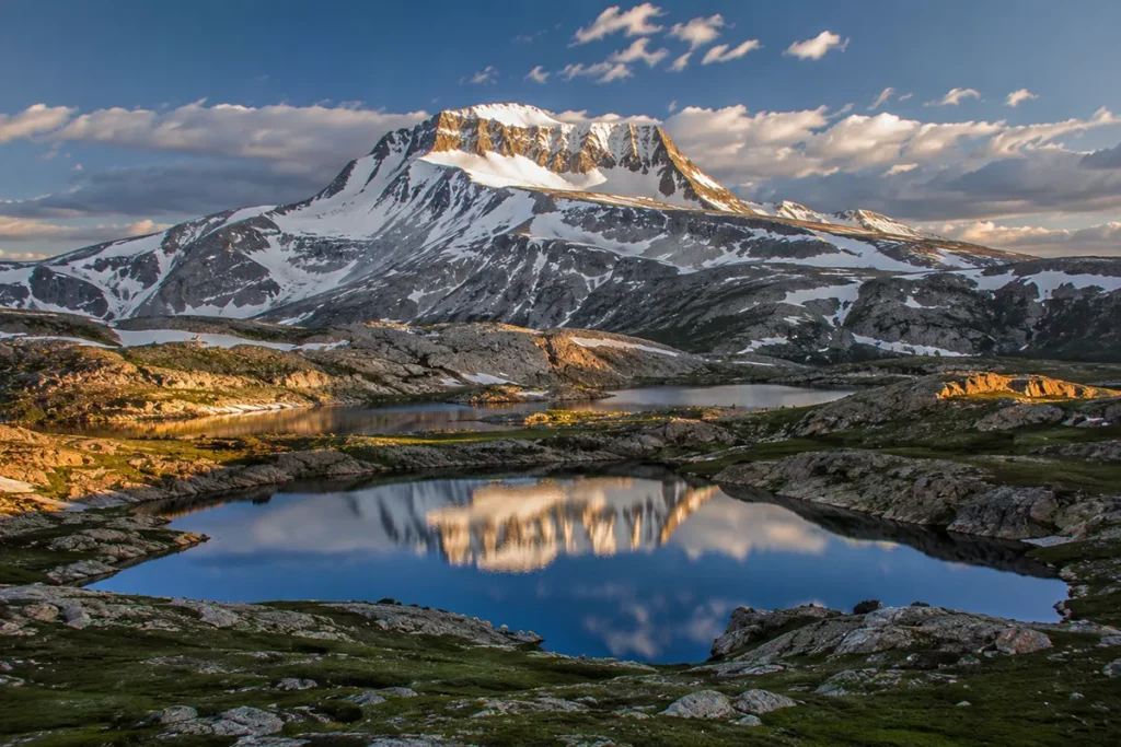
Cloud Peak (13,167 ft)
The high point of the range and the centerpiece of the Cloud Peak Wilderness. The standard route from Battle Park is a strenuous 22-mile round-trip backpack with a non-technical Class 2 scramble to the summit. The peak is granite. The views from the top span hundreds of miles in every direction.
Cloud Peak Wilderness
189,000 acres of designated wilderness, with high alpine lakes, talus-strewn cirques, and over 30 named peaks above 12,000 feet. Trail miles: roughly 250. This is the serious backpacking core of the range. Best accessed from Buffalo, Wyoming (east side) or Tensleep, Wyoming (west side).
Bighorn Scenic Byway (US-14)
A 58-mile mountain drive from Dayton to Greybull, Wyoming, passing through forests, alpine meadows, waterfalls (Shell Falls is the iconic stop), and dramatic canyons. The Bighorn Scenic Byway is one of the most accessible mountain drives in the West and one of the best ways to see the range without hiking.
Cloud Peak Skyway (US-16)
A 45-mile drive from Buffalo to Tensleep, Wyoming, crossing the southern Bighorns. Slightly less famous than US-14, but equally spectacular. Locally called “The Sweet 16.”
Medicine Wheel National Historic Landmark
High in the Wyoming Bighorns at 9,962 feet — a stone medicine wheel laid out by Indigenous peoples roughly 700 years ago, 80 feet in diameter, with 28 stone spokes.
This is one of the most significant Indigenous ceremonial sites in North America.
The site is still used by Plains tribes for ceremonial purposes and is protected jointly by the Forest Service and a council of regional tribes. Access from US-14 Alternate.
Hole-in-the-Wall Country
The remote southern Bighorns near Kaycee, Wyoming, contain the legendary Hole-in-the-Wall — the natural canyon outlaw hideout used by Butch Cassidy, the Sundance Kid, and the Wild Bunch in the late 1800s. Accessible via dirt roads from Kaycee.
Wildlife
The Bighorns support a major Greater Yellowstone–adjacent wildlife community:
Bighorn sheep — the range’s namesake. Reintroduced populations exist throughout the range.
Elk and mule deer — abundant.
Moose — present in the wet drainages of the Cloud Peak Wilderness.
Mountain lions — present, rarely seen.
Black bears — common.
Grizzly bears — not currently established in the Bighorns. The range is east of the main Greater Yellowstone grizzly range. Dispersing grizzlies are increasingly common as the regional population expands.
Wolves — recolonizing, with a small but growing population in the northern Bighorns.
Carry bear spray in the high country. See our Montana bear guide for protocols.
Where to Base Yourself
From Montana: Billings or Hardin
If you’re approaching the Bighorns from Montana, Billings is the best regional base. Population about 117,000, full-service city, major airport (BIL), about 1.5 hours from Sheridan WY and 90 minutes from Bighorn Canyon NRA.
Hardin, smaller (population ~4,000), is closer to Bighorn Canyon NRA and Little Bighorn Battlefield. Best for a focused day combining battlefield + canyon.
Fort Smith is the tiny community at the entrance to the Bighorn Canyon NRA and serves the trout-fishing crowd on the Bighorn River.
From Wyoming: Sheridan or Buffalo
Sheridan, Wyoming (population ~17,000) is the main gateway city for the eastern Bighorns. Strong outdoor industry, ski/snowboard infrastructure at Antelope Butte in winter, and direct US-14 access into the range.
Buffalo, Wyoming sits at the southeastern foot of the range and serves the Cloud Peak Wilderness east-side trailheads. Historic downtown.
Tensleep, Wyoming serves the western side of Cloud Peak Wilderness.
The Honest Trip Recommendation
Here’s what I’d actually do as a Montana traveler planning a Bighorns visit:
Option 1: The Honest Montana Day
Base in Billings or Hardin. Spend the day driving the Bighorn Canyon NRA loop, visit Yellowtail Dam, fly fish the Bighorn River below Afterbay if you have a license, stop at Little Bighorn Battlefield National Monument on the way back. This is the Montana-side experience.
Option 2: The Two-State Bighorns Trip
Base in Sheridan WY (or Billings/Hardin then drive south). Drive the Bighorn Scenic Byway (US-14) over the range one day, do a day hike to a Cloud Peak Wilderness lake the next day, visit the Medicine Wheel National Historic Landmark on the third day. Plan three to four days.
Option 3: The Full Cloud Peak Backpack
Drive south from Montana to either Buffalo or Tensleep, WY, and commit to a multi-day backpack into the Cloud Peak Wilderness. This is the serious version. Five to seven days.
Don’t try to do the Bighorns from a Montana basecamp without significant Wyoming driving. The math doesn’t work.
Best Time to Visit
The Bighorns have a moderately short alpine hiking season due to high elevation.
Late June through mid-September is prime for the Wyoming high country. The Cloud Peak Skyway opens by Memorial Day weekend; the Bighorn Scenic Byway is generally open mid-May to late October.
July and August are peak visitor season. Wildflowers peak in late July.
September offers fewer crowds, fall aspen color, and cooler temperatures, but increased weather risk.
Bighorn Canyon NRA is accessible year-round on the Montana side. Best fishing on the Bighorn River below Yellowtail Dam is fall through spring.
Winter brings backcountry skiing at Antelope Butte (Wyoming side), snowmobiling, and ice fishing on Bighorn Lake.
Personal Tips
Don’t be fooled by the “Bighorn Mountains Montana” framing. This is one of the few cases where Montana travel writing is misleading. The Bighorns are a Wyoming range. Plan accordingly.
The Bighorn Canyon NRA is genuinely worth a day — Devil Canyon Overlook, Yellowtail Dam interpretation, and the wild-horse-watching opportunities (Pryor Mountains adjacent) make it a substantive Montana destination.
The Bighorn River fly fishing is world-class. If you’re a fly fisher, the tailwater below Yellowtail and Afterbay dams is one of the top-five trout fisheries in North America. Brown and rainbow trout average 14–18 inches. Bring a guide; the access points are limited and learning the river takes time.
Combine your trip with Little Bighorn Battlefield. Most travelers don’t realize how close these sites are. A combined day at Bighorn Canyon NRA and the battlefield is one of the best southeast Montana experiences.
The Medicine Wheel is significant. If you go to the Wyoming Bighorns and you have any interest in Indigenous history, the Medicine Wheel National Historic Landmark is worth the detour. It’s a working ceremonial site that’s been used continuously for centuries.
Cloud Peak is harder than it looks. The 22-mile round-trip is no joke. Real Class 2 scrambling near the top, weather exposure, and altitude. Plan three days minimum.
Bighorn Canyon NRA fees apply. Standard NPS interagency pass works. Without a pass, expect entrance fees.
Bring a Wyoming fishing license if you’ll fish. Montana licenses don’t transfer.
Practical Info Box
| Item | Detail |
|---|---|
| Highest peak | Cloud Peak, 13,167 ft (Wyoming) |
| Range length | ~150–200 miles, predominantly Wyoming |
| Montana portion | Small northern toe in Big Horn County (Decker area) |
| National Forest | Bighorn National Forest (Wyoming), 1.12 million acres |
| Major wilderness | Cloud Peak Wilderness, 189,000 acres (all Wyoming) |
| Montana-accessible park unit | Bighorn Canyon National Recreation Area (straddles MT–WY) |
| Major dam | Yellowtail Dam (1966), created Bighorn Lake |
| Bedrock | Precambrian basement, ~3.25 billion years old |
| Major scenic drives | Bighorn Scenic Byway (US-14), Cloud Peak Skyway (US-16) |
| Cultural site | Medicine Wheel National Historic Landmark (WY) |
| Best basecamp from MT | Billings, then drive south to Sheridan WY |
| Best basecamp in WY | Sheridan, Buffalo, or Tensleep |
| Bear spray | Recommended in high country |
Final Thoughts
The Bighorn Mountains are not a Montana range, and any honest travel guide should say so. The Montana portion of the actual mountains is a small set of foothills around Decker — geographically interesting but not the Bighorns experience most travelers are seeking.
What Montana does offer that’s tied to the Bighorns is two-fold: Bighorn Canyon National Recreation Area is a genuine destination with world-class trout fishing, dramatic limestone canyons, and a National Park Service interpretation of the dam and the river.
And the cultural geography of the area — Crow Tribal lands, Little Bighorn Battlefield, the Pryor Mountains adjacent — is some of the most historically dense ground in the West.
If you want the alpine Bighorns — Cloud Peak Wilderness, the Bighorn Scenic Byway, the Medicine Wheel — accept that you’re driving into Wyoming. Sheridan is 90 minutes south of Billings. The drive is easy. The range is worth it.
For broader context on how the Bighorns fit alongside Montana’s actual mountain ranges, see the full Montana mountain ranges guide.
Frequently Asked Questions
Are the Bighorn Mountains in Montana?
Only the northern foothills extend into Big Horn County, Montana, near Decker. The vast majority of the range — including all the major peaks, the Cloud Peak Wilderness, and the Bighorn National Forest — is in Wyoming.
What’s the highest peak in the Bighorn Mountains?
Cloud Peak at 13,167 feet, in Wyoming, in the Cloud Peak Wilderness Area.
Can you see the Bighorn Mountains from Montana?
Yes — from the southern portions of Big Horn County, Montana, you can see the northern Bighorns rising to the south. They’re also visible from elevated points around Hardin and the Crow Agency area.
What is Bighorn Canyon National Recreation Area?
A 120,000-acre National Park Service unit straddling the Montana–Wyoming border, centered on Bighorn Lake (created by Yellowtail Dam in 1966). The Montana portion is accessible from Fort Smith and is the major Montana-side experience associated with the Bighorn Mountains.
Is the Bighorn River worth fishing?
Absolutely. The tailwater section below Yellowtail and Afterbay dams is widely considered one of the top blue-ribbon trout streams in North America, with dense populations of brown and rainbow trout.
What is the Medicine Wheel?
A stone medicine wheel laid out by Indigenous peoples roughly 700 years ago at 9,962 feet in the Wyoming Bighorns. Eighty feet in diameter with 28 spokes. One of the most significant Indigenous ceremonial sites in North America, still actively used.
How far are the Bighorn Mountains from Billings, Montana?
The Wyoming high country is about 90 minutes to 2 hours by car from Billings. Bighorn Canyon NRA on the Montana side is about 90 minutes from Billings.
What’s the connection between the Bighorn Mountains and the Crow Tribe?
The range and the river are named in English for the bighorn sheep. The Crow Tribe’s traditional homeland surrounds the range, and the Crow consider this country sacred. The Apsaalooke (Crow) name for the river is Iisaxpúatahcheeaashisee — “Big Horn Sheep River.”
Are the Bighorn Mountains part of the Rocky Mountains?
Yes, geologically, though the Bighorns are an outlying eastern range somewhat separated from the main Rocky Mountain chain by the Bighorn Basin and the Powder River Basin.
Are there grizzly bears in the Bighorn Mountains?
A resident grizzly population is not established. Dispersing grizzlies from the Greater Yellowstone Ecosystem have been increasingly documented. Black bears are common throughout.