The first time I drove the Beartooth Highway, I had to pull over three separate times in the first ten miles past Red Lodge because I genuinely could not process what I was looking at.
The road climbs nearly 6,000 feet in switchbacks across a vertical wall of granite and ends up on a plateau that feels like another planet.
I’ve been back probably forty times since, and the only thing that’s changed is I now know where to stop.
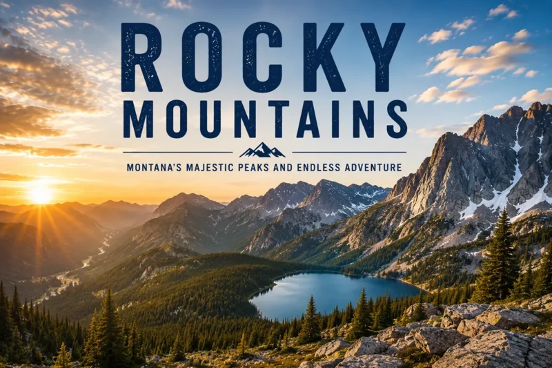
The Beartooth Mountains are Montana’s highest range, anchored by 12,807-foot Granite Peak — the state’s high point. They sit in south-central Montana and northwest Wyoming and contain 944,000 acres of the Absaroka–Beartooth Wilderness. The Beartooth Highway (US-212) is the headline experience, but the real magic is in the alpine plateau itself, the hundreds of lakes, the wildlife, and the trail system out of Red Lodge and Cooke City. The driving season runs roughly Memorial Day through mid-October, with the sweet spot from mid-July through early September.
Why the Beartooths Are Different
Montana has bigger wilderness areas. It has more famous mountains. But it doesn’t have anywhere else quite like the Beartooths.
The reason is the plateau. Most mountain ranges in the Lower 48 are ridge-and-valley systems — you walk up a drainage, you hit a pass, you drop into the next drainage.
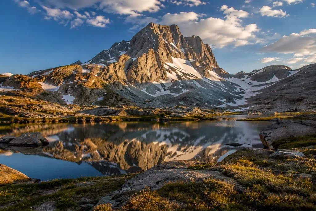
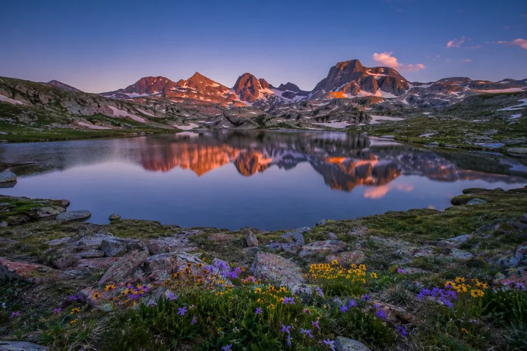
The Beartooths flip that. The high country here is a vast, rolling, treeless plateau sitting at 10,000 to 11,000 feet, dotted with hundreds of glacially carved lakes and ringed by peaks that punch up another 1,500 to 2,500 feet above it.
It’s the closest thing in the contiguous United States to an Arctic tundra ecosystem, and walking out onto it for the first time genuinely doesn’t compute. Your brain wants the trees to come back.
The other distinguishing fact: this is some of the oldest exposed rock in North America. The Beartooth basement granite has been dated to around 2.8 billion years — Archean-era stuff, older than free oxygen in the atmosphere.
You’re walking on rock that predates almost everything. I’m not a geologist, but standing on Beartooth Pass with that fact in your head changes the experience.
For broader context on how the Beartooths fit into the state’s geography, see the rest of Montana’s mountain ranges and the Montana elevation guide.
Where the Beartooths Are
The Beartooths straddle the Montana–Wyoming border in the south-central part of the state. The Montana side covers parts of Carbon, Stillwater, Park, and Sweet Grass counties.
The Wyoming side drops into Park County, Wyoming, and the range terminates at the northeast corner of Yellowstone National Park.
The two gateway towns are Red Lodge, Montana on the northeast and Cooke City on the southwest. The Beartooth Highway (US-212) connects them, climbing over Beartooth Pass and Colter Pass to make the loop possible.
From Billings, Red Lodge is about an hour southwest. From Bozeman, you’re looking at three hours either via Livingston and the Paradise Valley up through Yellowstone, or south on I-90 and then west on US-212 (the more direct option).
If you’re approaching from Yellowstone’s Northeast Entrance — which is the move I’d recommend for first-timers — you’ll come out of Lamar Valley, cross through Cooke City, climb Colter Pass, and start onto the Beartooth Plateau without realizing what’s about to happen. That’s the order I always recommend driving it.
Granite Peak: Montana’s Highest Point
Granite Peak sits at 12,807 feet and is the technical, weather-prone, glacier-flanked high point of the state. It’s not a casual hike.
Granite is consistently listed among the harder state high points in the country — the easy route is rated Class 4 with mandatory exposure, the standard “Southwest Ramp” route involves snow travel and a multi-day approach, and the weather pattern at that elevation can shut you down in an afternoon.
First ascent was made on August 29, 1923 by a small party that included Elers Koch, James C. Whitham, and R.T. Ferguson.
I’m not going to pretend I’ve stood on the summit. I’ve made it to the East Rosebud high camps below the peak and turned around when a thunderstorm rolled in faster than the forecast said it would.
The honest truth about Granite is that most people who plan to climb it don’t, and that’s fine. There are far better ways to experience the Beartooths than getting weathered off the state high point.
If you do want to attempt it, the standard approach is from the West Rosebud trailhead via Mystic Lake, up to Froze-to-Death Plateau, and then onto the peak from the southwest. Plan three days, a partner with snow and rock experience, a satellite communicator, and a real weather window. Or hire a guide.
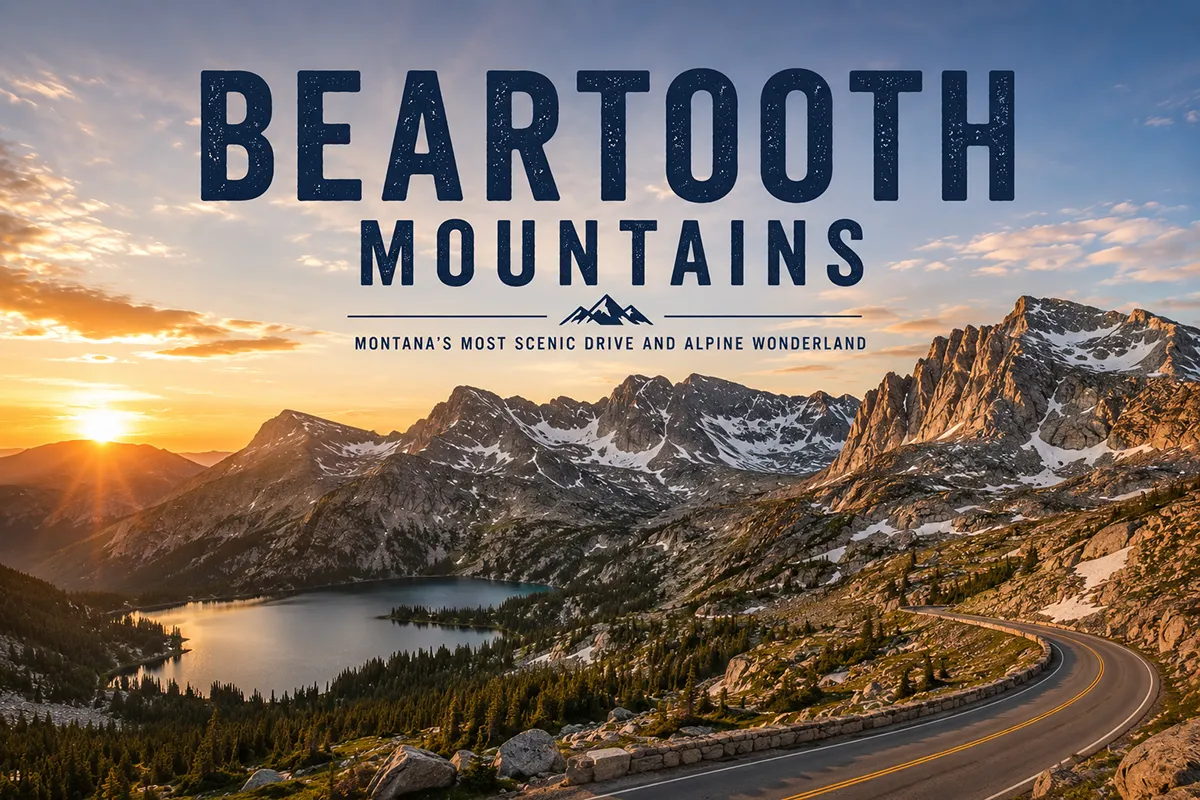
The Beartooth Highway
Charles Kuralt famously called the Beartooth Highway “the most beautiful drive in America” — and unlike most travel-writer quotes that get repeated forever, this one genuinely holds up.
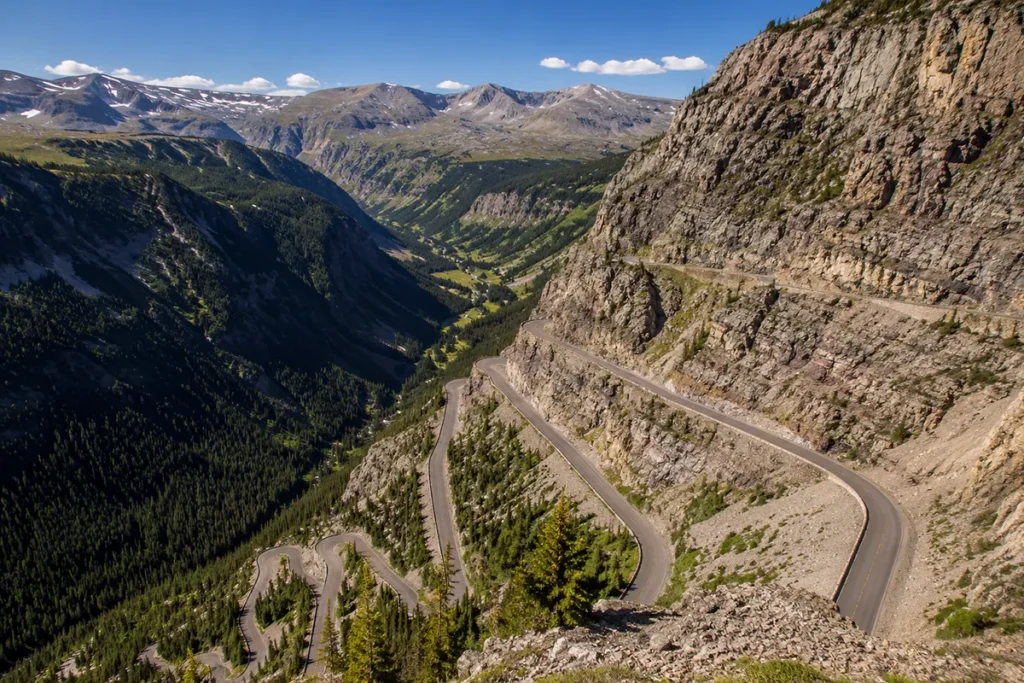
US-212 connects Red Lodge to Cooke City over a 68-mile stretch that climbs to Beartooth Pass at 10,947 feet — the highest paved road in Montana and the second-highest in the Northern Rockies.
The road is an engineering monument. It was built between 1932 and 1936 as a Depression-era public works project to give Red Lodge an economic lifeline after the coal mining collapsed, and the original surveyors said it couldn’t be built. They were nearly right.
The Driving Season
The Beartooth Highway is closed in winter. Period. The Wyoming side typically opens around Memorial Day weekend (late May), and full top-to-bottom opening usually follows by early to mid-June.
The road closes for the season in mid-October, sometimes earlier if storms hit hard. Snow is possible any month — I’ve driven through snow flurries on the plateau in late August.
The Montana Department of Transportation and Wyoming DOT both post current status. Check before you go. The road also closes intermittently during summer storms.
What the Drive Actually Looks Like
Driving east-to-west from Red Lodge: you start in conifer forest along Rock Creek, the road begins climbing, and within about 12 miles you hit the Rock Creek Vista turnout — a paved pullout where you can see the highway switchbacks below you stacked like ribbon candy. Most people stop here.
Above that, the trees thin and disappear. You’re on the plateau. The road runs nearly flat across alpine tundra at 10,000+ feet for the next 20 miles, with dozens of small unnamed lakes visible from the road and the Twin Lakes Overlook as the marquee stop.
You hit Beartooth Pass itself, drop down past the Top of the World Store (a real place — small, expensive, sells gas and snacks at altitude), traverse some additional plateau, and then descend along Pilot and Index Peaks down into Cooke City. The whole drive is about three hours if you stop the appropriate amount.
The Absaroka–Beartooth Wilderness
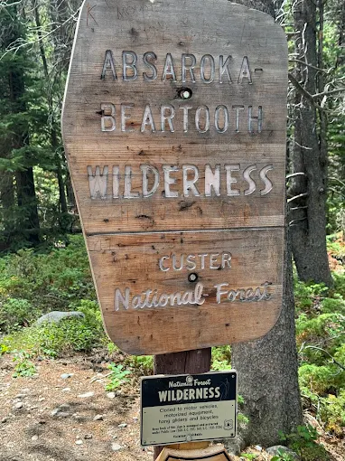
The Beartooths are protected primarily within the Absaroka–Beartooth Wilderness, a 944,000-acre designated wilderness area managed jointly by the Custer Gallatin National Forest (in Montana) and the Shoshone National Forest (in Wyoming).
It’s the seventh-largest wilderness in the Lower 48 and one of the most ecologically intact mountain ecosystems in North America.
What “wilderness designation” means in practice: no roads, no motorized vehicles, no mountain bikes, no permanent structures. Foot and horseback only. You’re on your own out there in a way that’s harder and harder to find in modern America.
The wilderness contains nearly 1,000 alpine lakes (with official estimates often citing roughly 950) — I’ve heard counts ranging from 900 to over 1000 depending on whether you count tarns and snowmelt pools — and roughly 21 to 107 active glaciers, though that number has been shrinking with each decade.
Grasshopper Glacier, on the south side of the divide, is famous for preserving the bodies of millions of migrating grasshoppers from a Pleistocene swarm trapped and frozen in the ice.
The Best Hikes in the Beartooths
There are dozens of legitimate trails, but here are the four I’d send anyone to first, ranked by accessibility.
The Beaten Path (East Rosebud to Cooke City)
This is the classic Beartooth thru-hike: roughly 26 miles from the East Rosebud trailhead near Roscoe, Montana to Cooke City, passing more than a dozen alpine lakes including Elk Lake, Rainbow Lake, Lake at Falls, and Fossil Lake.
Three to five days at a reasonable pace. Best done in late July through August. You’ll need a shuttle.
The trail is called “The Beaten Path” only because it’s the established route — it’s actually one of the wildest and most spectacular backpacking trips in the West.
I did it over four nights in early August one year and saw a moose, a black bear, three different grizzly tracks, and exactly one other group of hikers in the high country.
Lake Plateau via West Rosebud
The Lake Plateau is the Beartooths’ interior — an enormous, gently rolling tundra basin at 10,000 feet with dozens of lakes and views in every direction.
The standard access is up the West Rosebud trail from the Mystic Lake trailhead, then up to Princess Lake and onto the plateau. This is a two- or three-day trip rather than a thru-hike, and it’s the move if you want to be in the plateau country rather than passing through it.
Glacier Lake Trail (Wyoming side)
A short, steep day hike on the Wyoming side off US-212, climbing about 1,000 feet over two miles to Glacier Lake — a striking alpine lake set against a granite headwall.
This is one of the few day-hike options that gets you into genuine alpine terrain without committing to overnight gear. Bring a wind shell; the lake gets hammered by afternoon weather.
Hellroaring Plateau
Access via a high-clearance forest road off US-212. The Hellroaring Plateau is one of the easier ways to walk on Beartooth tundra without much vertical effort — once you’ve driven to the trailhead, you’re already at 10,000 feet.
From there, an open meadow walk takes you out to the edge of the plateau with views down into the East Rosebud drainage. This is my recommendation for older travelers, families, or anyone who wants the alpine experience without the climb.
For broader hiking context across the state, see our list of things to do in Montana and the Montana bucket list.
Wildlife in the Beartooths
The Beartooth–Absaroka complex is part of the Greater Yellowstone Ecosystem, which means you get the full Yellowstone wildlife portfolio: grizzly bears, black bears, gray wolves, mountain lions, mountain goats, bighorn sheep, moose, elk, mule deer, pronghorn (lower elevations), and wolverines.
Grizzly bears are present throughout the range. The Beartooth front and the East Rosebud drainage in particular have active grizzly populations. Carry bear spray, sleep with a clean camp, and read our Montana bear guide before you go.
Mountain goats are the iconic Beartooth alpine species. The Hellroaring Plateau and the upper East Rosebud drainage are reliable spots. They’re not native to the Beartooths — they were introduced in the 1940s and the population has thrived, sometimes at the expense of bighorn sheep range.
Wolves have recolonized the range from Yellowstone since the 1995 reintroduction. You won’t often see them in the high country, but the Lamar Valley wolf-watching scene just south is one of the best in North America — see our Yellowstone wolf watching guide.
Pikas — small alpine lagomorphs that look like potato-sized rabbits — live in the talus fields above 10,000 feet. They make a distinctive eep! call that you’ll hear before you see them. Climate change is steadily pushing them upslope.
Where to Base Yourself
Red Lodge, Montana (Northeast Gateway)
Red Lodge is the bigger and more developed of the two gateway towns — population around 2,300, with restaurants, hotels, bars, a small downtown that retains its mining-and-ranching character, and Red Lodge Mountain ski area on the south side of town. This is where I’d base for most Beartooth trips.
Drive time from Billings: about 65 minutes. From the airport in Billings, you can be on the Beartooth Highway in 90 minutes total.
Cooke City, Montana (Southwest Gateway)
Cooke City is the tiny, end-of-the-road community at the southwest entrance to the Beartooths — population around 100 in the winter, several hundred in summer.
It’s the only town in the U.S. accessible only by passing through a national park (Yellowstone in summer, or via plowed roads only from Gardiner in winter when the Beartooth Highway is closed).
Base here if you want immediate access to the Yellowstone Northeast Entrance, the Lamar Valley wolf scene, and the southwest Beartooth trailheads. Lodging is limited — a few motels, some cabins, an RV park.
Day-tripping from Billings, Bozeman, or Gardiner
You can absolutely do the Beartooth Highway as a day trip from Billings or even Bozeman, especially if you’re combining it with a Yellowstone loop.
From Bozeman, the most efficient loop is: south through Paradise Valley to Gardiner, into Yellowstone, north through Lamar Valley, out Northeast Entrance, over Beartooth Pass to Red Lodge, then back to Bozeman via I-90. Full day, roughly 12 hours of driving with stops.
Weather and the Best Time to Visit
The Beartooths are high country, and high country has its own weather. The basic rules:
Mid-July through mid-September is the prime window. Trails are clear of snow, the highway is open, lakes are accessible, and afternoon storms — while frequent — are typically short.
Early summer (June) can be excellent for the lower trails but expect snow on the passes and the plateau. The Beartooth Highway often has snow walls 10–15 feet high on either side of the road in June.
Fall (mid-September through early October) is my favorite time. The crowds are gone, the aspens are turning, and the larches (in the lower drainages) go gold. Risk: storms. I’ve been snowed on at 9,000 feet in late September more than once. See our Montana in September guide for full context.
Winter the highway is closed, and the high country is the domain of backcountry skiers, snowmobilers, and a very small number of experienced ice climbers. Cooke City becomes a snowmobile mecca; Red Lodge has lift-served downhill at Red Lodge Mountain.
Afternoon thunderstorms are the single biggest hazard in summer. The pattern: blue sky in the morning, clouds building by noon, full thunderstorm by 2 p.m. Plan to be off ridges and high passes by 1 p.m. in July and August. Bring full rain gear regardless of forecast.
For temperature context, see how cold does it get in Montana and does it snow in Montana.
Personal Tips: What I Wish I Knew
Don’t underestimate altitude. The Beartooth Plateau sits at 10,000+ feet. If you’ve come from sea level, expect a headache, fatigue, and reduced exertion capacity on day one. Drink twice the water you think you need. If you’re planning a peak ascent or a multi-day backpacking trip, build in an acclimatization day in Red Lodge (5,500 ft) before going high.
The “Top of the World Store” is a real waypoint. It’s at 9,500 feet on the Wyoming side, sells gas, snacks, and fishing licenses, and is the only commercial stop between Red Lodge and Cooke City when the highway is open. Cell service nonexistent, prices reflect the location, but it’s a useful landmark.
Cell service is essentially zero in the wilderness. I carry a Garmin inReach Mini for all backcountry trips here. The two-way satellite messaging has bailed me out twice — once for a weather routing call and once for a delayed-pickup notification.
Fish the high lakes. Many Beartooth alpine lakes were stocked with cutthroat and brook trout decades ago and have self-sustaining populations now. A Montana resident or non-resident fishing license is required. The lakes ice out late — Fossil Lake and other 10,000+-foot lakes can be partially iced as late as early July.
Mosquito season is real, brief, and brutal. Late June through mid-July, the Beartooth high country mosquito hatch is one of the worst in Montana. By early August it’s mostly over. Bring DEET or picaridin and a head net. See our Montana bug season guide.
Night sky is world-class. The Beartooth Plateau is one of the darkest accessible night-sky locations in the Lower 48. A clear August night with a new moon is genuinely transformative. See our Montana night sky post for related stargazing context.
Gas up before the highway. The next gas after Red Lodge is Cooke City (60+ miles), or the Top of the World Store if open and stocked. Don’t head up the highway with a quarter tank.
Practical Info Box
| Item | Detail |
|---|---|
| Highest peak | Granite Peak, 12,807 ft (highest in Montana) |
| Beartooth Pass elevation | 10,947 ft |
| Wilderness area | Absaroka–Beartooth Wilderness, 944,000 acres |
| Driving season | Roughly Memorial Day to mid-October |
| Best hiking months | Mid-July through mid-September |
| Gateway towns | Red Lodge, MT (northeast) and Cooke City, MT (southwest) |
| Nearest major airport | Billings Logan International (BIL), ~65 min from Red Lodge |
| Wilderness permit | Not required for day use; group size limits apply |
| Bear spray | Required gear |
| Cell service | None in the wilderness, spotty in towns |
| Entry fee | Free (no park entrance fee; this is National Forest) |
Frequently Asked Questions
How tall are the Beartooth Mountains?
The Beartooth Mountains contain Montana’s highest peak — Granite Peak at 12,807 feet. The Beartooth Plateau itself sits at 10,000 to 11,000 feet, and dozens of peaks in the range exceed 11,500 feet.
Is the Beartooth Highway open year-round?
No. The Beartooth Highway (US-212 between Red Lodge and Cooke City) is closed in winter and typically open from late May (Memorial Day weekend) through mid-October, weather permitting.
Can you drive to the top of the Beartooth Mountains?
You can drive over Beartooth Pass at 10,947 feet on US-212, the highest paved road in Montana. You can’t drive to the actual summits of the high peaks — those require backcountry hiking and, for Granite Peak, technical climbing.
Are there grizzly bears in the Beartooth Mountains?
Yes. The Beartooths are part of the Greater Yellowstone Ecosystem and have an active grizzly bear population. Bear spray and proper food storage are essential.
How long does it take to drive the Beartooth Highway?
The drive from Red Lodge to Cooke City is about 68 miles and takes roughly two to three hours without stops. With photo stops and short walks, plan four to five hours.
Where do you stay near the Beartooth Mountains?
The two main gateway towns are Red Lodge, Montana (larger, more amenities) and Cooke City, Montana (smaller, Yellowstone-adjacent). Billings is about an hour from Red Lodge if you want a city base.
What’s the difference between the Beartooth Mountains and the Absaroka Range?
They’re adjacent but geologically distinct. The Beartooths are older Archean granite forming a high plateau; the Absarokas are younger Eocene volcanic rock forming more eroded peaks. Both are protected within the same wilderness area — the Absaroka–Beartooth Wilderness.
Can you climb Granite Peak without a guide?
You can, but you shouldn’t unless you’re an experienced mountaineer comfortable with Class 4 rock, snow travel, route-finding, and high-altitude weather. Many people who attempt Granite turn back. Hiring a guide significantly improves both your odds and your safety.
Final Thoughts
I’ve spent more time in the Beartooths than in any other Montana range outside of Glacier National Park, and the place still surprises me.
The combination of plateau geography, ancient granite, alpine wildlife, and that one unbelievable highway makes it the most unique mountain experience in the state — and probably one of the most unique in the country.
If you have a single weekend in Montana and you want to see something you won’t see anywhere else, drive the Beartooth Highway from Cooke City to Red Lodge, stop for at least one short walk on the plateau, and stay a night in Red Lodge.
If you have a week, do the Beaten Path or set up a basecamp at one of the high lakes. Either way, you’ll come back.
Save this guide for your trip planning, and check the range’s pillar overview for context on how the Beartooths fit alongside Montana’s other major ranges.