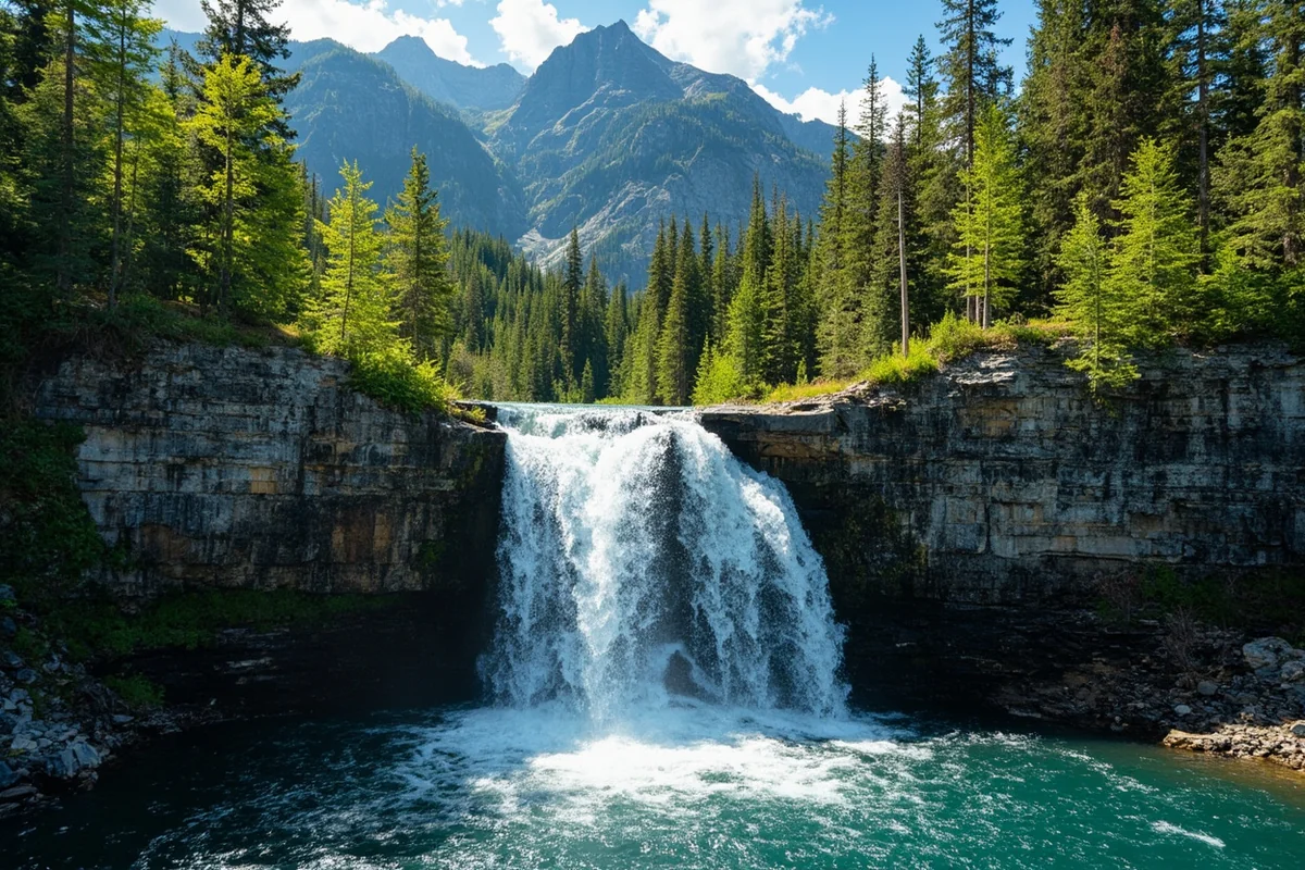
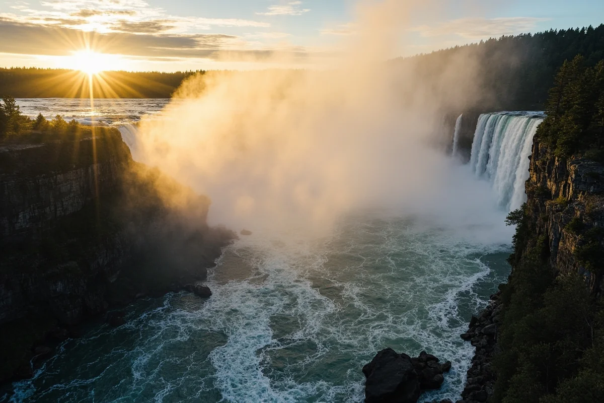
The moment I rounded the final switchback and heard the thundering roar echoing off the ancient rock walls, I knew Piegan Falls was about to become one of my favorite Montana waterfalls to visit.
Standing there last July, watching the milky glacial water plummet over 100 feet against a backdrop of snow-capped peaks, I completely understood why this waterfall remains one of Glacier National Park’s most treasured destinations.
- Piegan Falls is located in Glacier National Park, accessed via the Piegan Pass Trail or Siyeh Pass Trail
- Round-trip distance: approximately 9 miles from Siyeh Bend Trailhead
- Difficulty: Moderate to strenuous with 1,700+ feet elevation gain
- Best time to visit: Late June through September (peak flow in July)
- No permit required for day hiking, but park entrance fee applies ($35/vehicle)
- Allow 5-7 hours for the complete hike with waterfall viewing time
- Bear spray is essential — I saw grizzly tracks on my last visit
What Makes Piegan Falls Special
I’ve hiked to dozens of waterfalls across Montana over the past eight years, and Piegan Falls stands apart for several reasons. First, there’s the setting — this isn’t just a waterfall you walk up to. It’s a destination you earn through miles of stunning alpine terrain.
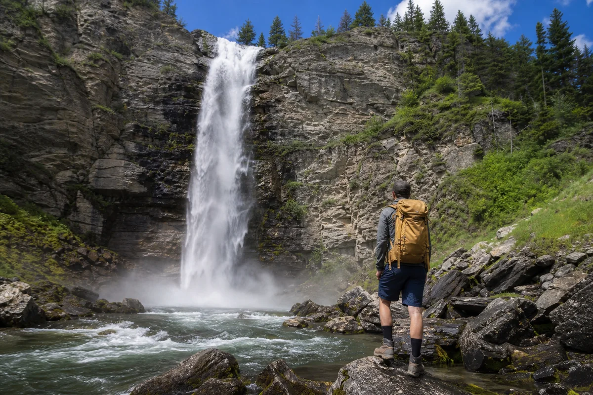
The falls themselves drop approximately 100-120 feet in a dramatic horsetail cascade. During peak runoff in early July when I visited, the volume was absolutely spectacular, sending mist hundreds of feet into the air.
What really sets Piegan Falls apart is its source. The water feeding these falls comes directly from Piegan Glacier (one of the park’s remaining glaciers) and the snowfields of Piegan Mountain. This gives the water that distinctive milky-turquoise color that photographs beautifully.
Unlike some of the more accessible waterfalls in Glacier, such as Running Eagle Falls or McDonald Falls, reaching Piegan Falls requires commitment. But trust me, that effort filters out the crowds and makes the experience infinitely more rewarding.
Getting to the Trailhead
The primary access point for Piegan Falls is the Siyeh Bend Trailhead, located along the Going-to-the-Sun Road. During my recent trip, I drove from St. Mary Village, which took about 25 minutes to reach the trailhead.
Here’s what you need to know about reaching the starting point:
From the West Side (West Glacier/Apgar)
If you’re coming from the west entrance, plan for approximately 45-50 minutes of drive time. The route takes you over Logan Pass, which means you’ll need to time your trip around the Going-to-the-Sun Road opening (typically mid-June, weather dependent).
The Siyeh Bend Trailhead sits at mile marker 34.5, about 3.5 miles east of Logan Pass. There’s a small pullout area with room for maybe 15-20 vehicles.
From the East Side (St. Mary)
Coming from St. Mary is my preferred approach. The drive is shorter, and you’re less likely to hit the traffic backups that plague the west entrance during peak season.
The trailhead pullout is on the south side of the road. On a recent Saturday in August, I arrived at 6:45 AM and snagged one of the last spots. By 8 AM, cars were parked along the road for a quarter mile in each direction.
Vehicle Reservation System
Here’s something critical that trips up many first-time visitors: Glacier National Park implemented a vehicle reservation system for the Going-to-the-Sun Road corridor during peak season (typically late May through early September).
During my 2023 visit, I booked my entry permit on recreation.gov about three weeks in advance. Permits sell out quickly for popular time slots, especially between 7 AM and 3 PM.
If you can’t get a reservation, you can enter without one before 6 AM or after 3 PM (times vary by year, so check the current schedule). I’ve done the early morning approach and actually prefer it — cooler temperatures, fewer people on the trail, and better wildlife viewing opportunities.
Trail Details and Route Options
There are two main ways to reach Piegan Falls, and I’ve done both. Each has its advantages depending on your fitness level and what else you want to see.
Option 1: Via Siyeh Pass Trail (Most Direct)
This is the route I recommend for most hikers specifically targeting the waterfall. You’ll start at Siyeh Bend Trailhead and follow the Piegan Pass/Siyeh Pass Trail.
| Trail Metric | Details |
|---|---|
| Total Distance (to falls) | 4.5 miles one way |
| Elevation Gain | 1,750 feet |
| Trail Surface | Well-maintained, rocky in sections |
| Difficulty Rating | Moderate to Strenuous |
| Average Completion Time | 5-7 hours round trip |
The trail begins with a gradual descent to Siyeh Creek, which you’ll cross on a sturdy footbridge. From there, the real climbing begins.
During the first two miles, you’ll gain elevation steadily through subalpine forest. I counted at least a dozen different wildflower species along this stretch during my July hike — beargrass, paintbrush, glacier lilies, and fireweed were particularly abundant.
Around mile 2.5, the forest opens up dramatically. This is where Glacier National Park starts showing off. You’ll see Piegan Mountain and Going-to-the-Sun Mountain ahead, with Preston Park’s famous meadows below.
The final push to the falls involves some steeper switchbacks. The trail condition varies by season — during my early July visit, there were still snow patches to navigate around mile 4.
Option 2: Via Preston Park Trail
For a slightly longer but more scenic approach, you can access Piegan Falls through Preston Park. This route adds about a mile each way but passes through some of the most beautiful alpine meadows in the entire park.
I took this route during a late August visit, and the wildflowers were past peak but the mountain views were unobstructed. This approach also gives you better views of Piegan Falls from a distance before you reach the base.
Option 3: Point-to-Point via Siyeh Pass
Experienced hikers looking for a full-day adventure can combine Piegan Falls with a traverse over Siyeh Pass. This creates a spectacular 10+ mile point-to-point hike that ends at Sunrift Gorge.
You’ll need to arrange a shuttle (the free park shuttle runs along Going-to-the-Sun Road) or have two vehicles. I did this route last summer with a group of four, and we all agreed it was one of the best day hikes we’d ever done.
What to Expect on the Trail
Let me walk you through the hike section by section, based on my multiple visits over the past few years.
Miles 0-1: Forest and Creek Crossing
The trail starts in a mixed conifer forest dominated by subalpine fir and Engelmann spruce. During my morning start times, I’ve consistently seen deer in this section. The path is well-marked and impossible to lose.
You’ll reach Siyeh Creek within the first half mile. The footbridge is solid and wide — no need for careful balancing. I’ve seen people in hiking sandals manage this crossing fine, though I always recommend proper hiking boots for the terrain ahead.
After crossing the creek, the trail bends south and begins climbing. The grade is gentle at first, maybe 5-7% incline.
Miles 1-2.5: The Climb Through Forest
This is where your legs start to feel the elevation. The trail maintains a steady uphill trajectory, gaining about 800 feet over this stretch.
I typically take a water break around mile 1.5, where there’s a natural opening in the trees with views of Cataract Mountain. It’s not an official viewpoint, but you’ll know it when you see it.
The forest begins to thin as you approach mile 2.5. Watch for Clark’s nutcrackers and gray jays — they’re everywhere along this trail and surprisingly bold around hikers eating snacks.
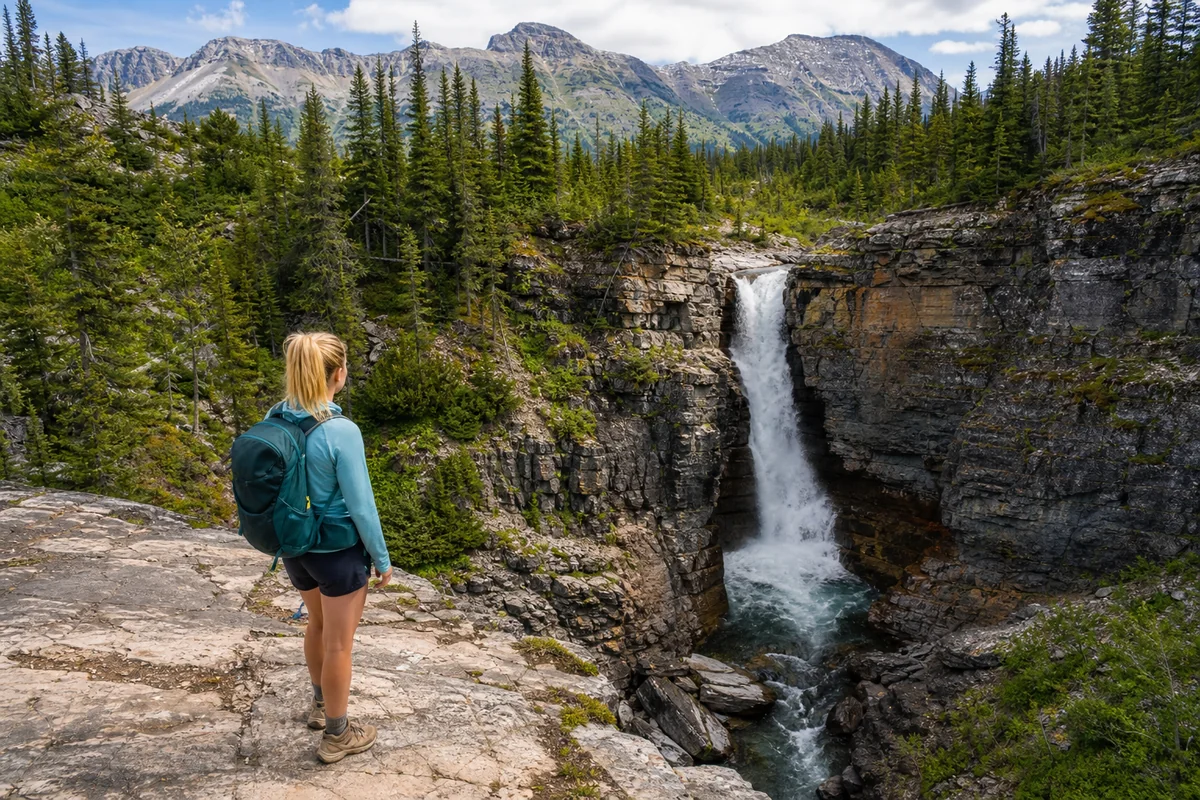
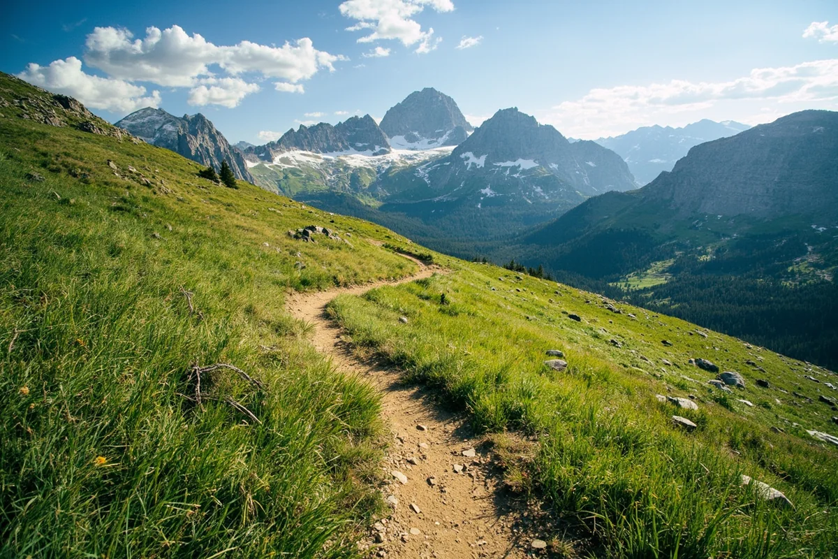
Miles 2.5-3.5: Alpine Transition
This section is magical. You emerge from the treeline into open alpine terrain with 360-degree mountain views. Piegan Mountain dominates the southern skyline, and on clear days, you can see all the way to Mount Siyeh to the northeast.
The trail quality remains excellent here, though it becomes rockier. I recommend trekking poles for this section, especially on the descent when tired legs make the uneven footing more challenging.
During my July hike, this stretch had several snow patches still crossing the trail. Most were easy to walk over, but one required a short sidestep onto stable rock.
Miles 3.5-4.5: Approach to Piegan Falls
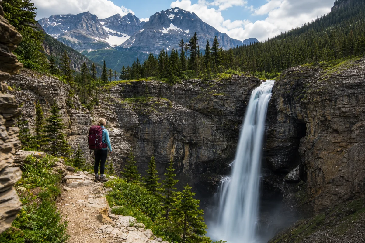
The final mile is the steepest and most exposed. You’ll gain another 500+ feet through a series of switchbacks carved into the rocky mountainside.
The views keep getting better with every step. Looking back, you can see the Going-to-the-Sun Road snaking along the mountainside — it looks impossibly small from up here.
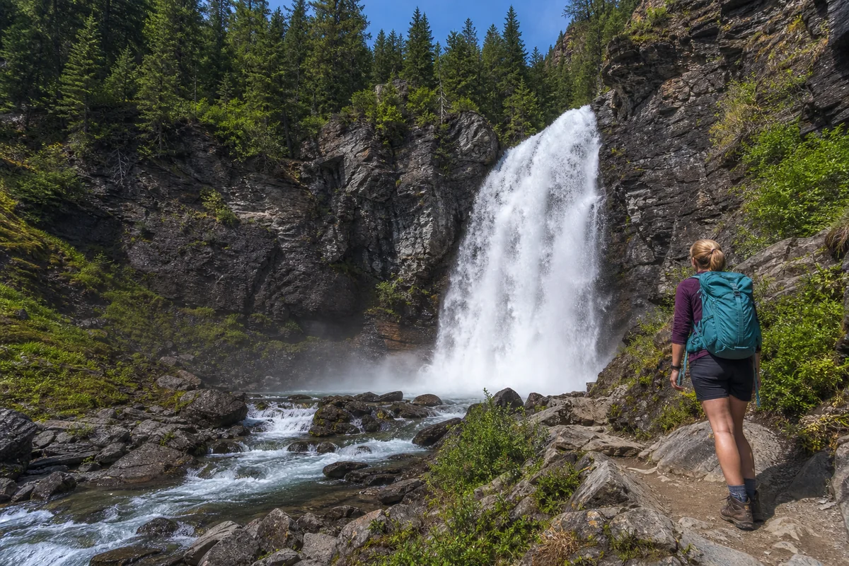
You’ll hear Piegan Falls before you see it clearly. The sound echoes off the cirque walls, building anticipation. The trail brings you to a rocky overlook area where most hikers stop to admire the falls.
Experiencing Piegan Falls Up Close
When I finally stood at the viewing area during my first visit, I was struck by the raw power of the water. Piegan Falls isn’t the tallest waterfall in Montana, but it’s one of the most dramatically situated.
The falls cascade down a sheer rock face in multiple tiers. During peak flow in early July, the main channel was probably 30 feet wide, throwing mist that drifted across the entire viewing area.
By late August, the flow diminishes significantly but the falls remain impressive. The reduced volume actually reveals more of the underlying rock structure, which has interesting color variations — bands of red argillite mixed with gray limestone.
Getting Closer to the Falls
A social trail leads down from the main viewing area toward the base of the falls. I’ll be honest — this route is steep, loose, and potentially dangerous. I’ve done it once and wouldn’t recommend it for most hikers.
The official viewing area provides excellent views and photo opportunities without the risk. During my last visit, I watched someone slip on the loose scree heading down and slide about 15 feet before catching themselves. Not worth it.
If you’re determined to explore further, the rocks near the water are extremely slippery from mist spray. I saw one photographer’s camera bag go sliding into the creek after she set it down on what looked like dry rock.
How Long to Spend at the Falls
I recommend budgeting at least 30-45 minutes at Piegan Falls. The viewing area has several flat rocks perfect for resting and having lunch.
On my July visit, I spent nearly two hours here — eating lunch, taking photos, and simply absorbing the scene. The temperature at the falls was noticeably cooler than the trail, maybe 10-15 degrees lower thanks to the mist and elevation.
Best Times to Visit Piegan Falls
Timing your visit can make the difference between a good experience and an unforgettable one. Here’s what I’ve learned from multiple trips.
Best Season: July
Mid-to-late July offers the ideal combination of maximum water flow and manageable trail conditions. The snow has typically melted from the trail, but snowmelt is still feeding the falls at near-peak volume.
During my July 12 visit, the flow was absolutely spectacular. The water was so powerful it created its own weather system — I could see the mist cloud from nearly a mile away on the trail.
August Visits
By August, water volume decreases but the experience remains worthwhile. The trails are drier and easier to navigate, and you’ll likely encounter fewer hikers.
Late August temperatures are also more comfortable for the climb. My August 24 hike was 20 degrees cooler than my July trip, and the reduced sweating meant I needed less water.
September Considerations
Early September can be excellent if weather cooperates. The crowds thin dramatically after Labor Day, and you might have the falls nearly to yourself on a weekday.
However, the falls are noticeably smaller by this point. A local I met on the trail described September Piegan Falls as “a respectable stream” compared to its July peak. Still beautiful, but different.
Best Time of Day
Morning light hits Piegan Falls directly, making it ideal for photography. I’ve started most of my hikes between 6:30 and 7:00 AM, reaching the falls around 10:00-10:30 AM.
Afternoon light can be harsh and creates challenging shadow conditions. If you do hike later, the golden hour before sunset provides nice warm tones, though you’ll need to be prepared for a partial descent in fading light.
Photography Tips for Piegan Falls
As someone who’s lugged camera gear up to these falls more times than I can count, here’s my hard-won advice for getting great shots.
Essential Gear
A wide-angle lens (16-35mm range) captures the falls with their mountain backdrop. I’ve gotten my best shots with a 24mm focal length, which includes enough context without distorting the scene.
Bring a neutral density filter if you want silky smooth water effects. During my July visit, midday conditions required an ND8 filter to get long exposures without overexposing.
A lightweight tripod is worth the weight if photography is a priority. I use a carbon fiber travel tripod that adds about 2.5 pounds to my pack.
Best Shooting Locations
The main viewing area offers three distinct shooting positions:
The high angle from the trail itself captures the falls in context with the surrounding cirque walls. This is my go-to for landscape-oriented shots.
Moving left along the viewing area gets you closer to the falls and provides a more vertical composition. The mist is heavier here, so protect your lens.
The far right edge of the viewing area offers a unique angle that includes more of the creek below the falls. I’ve used this angle for video clips with great results.
Dealing with Mist
Piegan Falls generates significant mist, especially during peak flow. I keep a microfiber cloth accessible for constant lens wiping.
On my July visit, I gave up on long exposures within 20 feet of the falls — the mist coated my filter within seconds of cleaning. Backing up 50 feet solved the problem while still capturing dramatic images.
Safety Considerations
Glacier National Park demands respect, and the trail to Piegan Falls is no exception. Here’s what you need to know to stay safe.
Wildlife Awareness
This is prime grizzly bear habitat. During my most recent visit, I saw fresh grizzly tracks in a muddy section around mile 3 — large enough that the hair on my neck stood up.
Carry bear spray and know how to use it. I keep mine in a hip holster where I can access it in seconds. The park offers free bear spray demonstrations at visitor centers.
Make noise on the trail, especially around blind corners. I talk, clap occasionally, or use a small bell. Solo hikers should be extra vigilant.
Mountain goats frequent the area around the falls. During my August visit, I watched a group of four goats traverse the cliffs above the falls. Keep your distance — they may look docile, but they’re wild animals with sharp horns.
Weather Hazards
Afternoon thunderstorms are common from July through August. I’ve been caught in two lightning storms above treeline in Glacier, and neither was fun.
Check the forecast before you go and plan to be below treeline by early afternoon if storms are predicted. The exposed approach to Piegan Falls is no place to be when lightning rolls in.
Trail Conditions
Snow can linger on the trail into July, especially in shadowed areas. Basic microspikes can be helpful early in the season.
The rocky sections near the falls become dangerously slippery when wet. During one misty afternoon visit, I watched my hiking partner’s feet go out from under her on a seemingly dry-looking rock.
What to Pack
Based on my experiences, here’s a complete packing list for the Piegan Falls hike:
- Water: Minimum 3 liters — I typically drink 2.5 on hot days
- Food: Lunch plus high-energy snacks (I bring more than I think I’ll need)
- Rain layer: Even on clear days, mist from the falls will get you wet
- Extra warm layer: Temperature drops significantly at the falls
- Sun protection: Hat, sunglasses, sunscreen (the alpine exposure is intense)
- Bear spray: Absolutely essential, no exceptions
- First aid kit: Basic supplies including blister treatment
- Map and navigation: Cell service is nonexistent on this trail
- Trekking poles: Highly recommended for the descent
- Headlamp: In case you’re out later than planned
Nearby Waterfalls Worth Combining
If you’re in the area for multiple days, several other waterfalls make excellent companion trips.
Saint Mary Falls is a shorter, easier hike on the east side of the park. I often recommend it for the day before or after Piegan Falls — it lets your legs recover while still enjoying a beautiful waterfall.
For another challenging option, Ptarmigan Falls offers a similar backcountry experience with fewer crowds. I did both falls on consecutive days last summer and loved the contrast.
Redrock Falls is accessible from the Many Glacier area and makes a perfect half-day trip if you want something less strenuous after tackling Piegan.
The Oberlin Falls area near Logan Pass provides easy access to multiple cascades if you’re limited on time or energy.
For a completely different experience, consider Kootenai Falls in northwest Montana — it’s more accessible and showcases a different geological character.
Where to Stay
Planning your accommodations strategically can make the Piegan Falls experience much more enjoyable.
East Side Options
I prefer staying on the east side of the park for this hike, which cuts 30+ minutes off the drive to the trailhead.
St. Mary Village offers several lodging options ranging from budget motels to nicer cabins. During my last visit, I stayed at a small cabin rental about a mile outside the park entrance. The early morning drive to Siyeh Bend took just 20 minutes.
For camping, St. Mary Campground puts you close to the action. I’ve done the Piegan Falls hike as a camping trip multiple times. Waking up already in the park eliminates vehicle reservation stress.
West Side Options
West Glacier and the Apgar area have more dining and amenity options but add significant drive time. If you’re staying here, plan for a very early departure to beat the crowds.
Many Glacier Alternative
The Many Glacier area is actually closer to Piegan Falls as the crow flies but requires a longer drive around the park. However, if you’re combining multiple hikes, Many Glacier puts you near several other excellent trails.
Planning Your Visit
Let me share the itinerary I recommend to friends who ask about visiting Piegan Falls.
The Night Before
Stay somewhere on the east side, within 30 minutes of the Siyeh Bend Trailhead. Eat a good dinner and get to bed early.
Morning of the Hike
Wake up around 5:30 AM. Eat a solid breakfast — you’ll need the fuel for 1,700 feet of elevation gain.
Arrive at the trailhead by 6:30-7:00 AM. This timing gets you ahead of the crowds and means you’ll reach the falls before the harsh midday light.
On the Trail
Pace yourself on the climb. I typically take 2.5-3 hours to reach the falls, with short breaks every 45 minutes or so.
Spend at least 30-45 minutes at the falls. Eat lunch, take photos, soak in the experience. You earned it.
Return Journey
The descent is faster but harder on the knees. I budget 2-2.5 hours for the return trip.
Plan to be back at the trailhead by early afternoon. This leaves time for a late lunch, a cold drink, and maybe another short activity in the park.
Comparing Piegan Falls to Other Park Waterfalls
Having visited most of the major waterfalls in Glacier National Park, I can offer some perspective on how Piegan Falls compares.
In terms of difficulty, Piegan Falls is one of the more challenging waterfall hikes in the park. It’s comparable to reaching Ipasha Falls but with better views along the way.
For sheer dramatic setting, only Rockwell Falls and perhaps Mokowanis Cascade rival Piegan Falls in my experience. The cirque setting is simply stunning.
If you’re looking for easier alternatives that still deliver impact, Sacred Dancing Cascade along McDonald Creek requires minimal effort and provides a completely different but equally beautiful waterfall experience.
Respecting This Special Place
A few words about Leave No Trace principles, which matter more in pristine areas like this.
Pack out everything you bring in. During my last visit, I was disappointed to find an energy gel wrapper near the falls. I picked it up and packed it out with my trash.
Stay on established trails. The alpine vegetation here is incredibly fragile and can take decades to recover from trampling. The social trails leading to unauthorized viewpoints cause real damage.
Keep wildlife encounters at a distance. The mountain goats near Piegan Falls have become somewhat habituated to humans, but feeding them or approaching too closely alters their natural behavior.
Final Thoughts
After multiple visits to Piegan Falls across different seasons and conditions, I can confidently say it’s one of Montana’s premier waterfall destinations. The combination of challenging trail, stunning alpine scenery, and dramatic waterfall creates an experience that stays with you.
Is it the easiest waterfall to reach in Montana? Not by a long shot. Compare it to a roadside attraction like Memorial Falls near Great Falls or the accessible Skalkaho Falls, and you’ll see Piegan Falls demands more from visitors.
But that effort creates value. Standing at the base of Piegan Falls after earning every step of the climb, watching glacial meltwater thunder over ancient rock with wild mountain peaks in every direction — that’s an experience you simply can’t replicate at a drive-up waterfall.
If you’re in reasonable hiking shape and willing to put in the work, Piegan Falls deserves a spot on your Montana itinerary. Just start early, bring the essentials, and give yourself enough time to truly appreciate what you’ll find at the end of the trail.
I’m already planning my next visit for this coming July, timing it with peak snowmelt for maximum water volume. Maybe I’ll see you on the trail.
Frequently Asked Questions
How do I get to Piegan Falls in Glacier National Park?
Piegan Falls is located along the Piegan Pass Trail, starting from the Sully Creek Trailhead on the Going-to-the-Sun Road. The trailhead is about 2 miles east of Logan Pass, and the falls are approximately 1.5 miles into the hike. I recommend arriving early during peak season since parking fills up quickly along this popular stretch of road.
How difficult is the hike to Piegan Falls Montana?
The hike to Piegan Falls is considered easy to moderate, with a well-maintained trail and only about 300 feet of elevation gain over 1.5 miles one way. It’s family-friendly and takes most hikers 30-45 minutes each direction. The trail can be muddy in early summer when snowmelt is heavy, so sturdy hiking boots are a must.
What is the best time of year to visit Piegan Falls?
The best time to see Piegan Falls is late June through mid-August when snowmelt creates powerful water flow and the Going-to-the-Sun Road is fully open. I visited in early July and the falls were absolutely roaring with glacial runoff. By late summer, water levels drop significantly, so timing your visit after spring thaw gives you the most dramatic views.
Do I need a park pass or reservation to see Piegan Falls?
Yes, you’ll need a Glacier National Park entrance pass, which costs $35 per vehicle for a 7-day pass or $80 for an annual pass. During peak summer months (late May through early September), you also need a vehicle reservation to enter the Going-to-the-Sun Road corridor between 6 AM and 3 PM. Book reservations at Recreation.gov starting in spring as they sell out fast.
What should I bring on the Piegan Falls hike?
Bring bear spray, plenty of water, layers for unpredictable mountain weather, and waterproof hiking shoes since the trail can be wet near the falls. I always pack a rain jacket even on sunny days because afternoon storms roll in quickly in Glacier. Don’t forget your camera—the turquoise glacial water against the rocky cliffs makes for incredible photos.
Can I swim at Piegan Falls in Glacier National Park?
Swimming at Piegan Falls is technically possible but not recommended due to extremely cold glacial water temperatures, often below 40°F even in summer. The water comes directly from snowmelt and nearby glaciers, making hypothermia a real risk. Most visitors enjoy the falls from the viewing area and save swimming for warmer lakes elsewhere in the park.
Is Piegan Falls crowded and how can I avoid the crowds?
Piegan Falls sees moderate crowds compared to more famous Glacier attractions, but the trailhead parking area fills quickly by mid-morning in July and August. I suggest hitting the trail before 8 AM or after 4 PM to enjoy a quieter experience. Visiting on weekdays or in early September after Labor Day also dramatically reduces the number of hikers you’ll encounter.
Sources