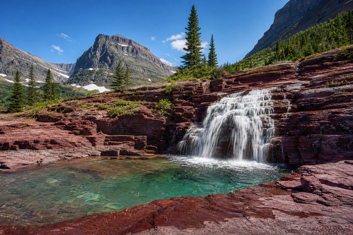
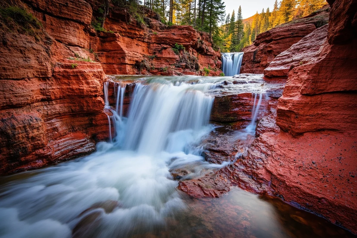
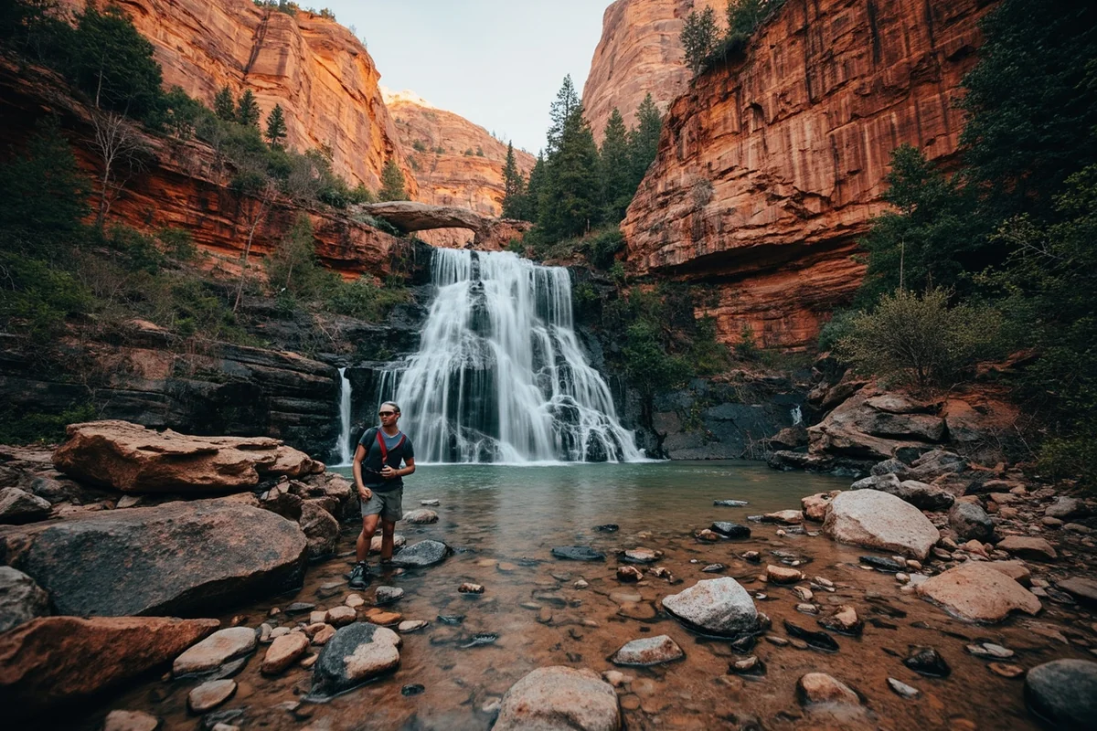
The moment I rounded the final bend on the Swiftcurrent Pass Trail and caught my first glimpse of Redrock Falls, I understood why this waterfall doesn’t need dramatic height to leave you speechless.
The deep crimson and maroon rocks framing the cascade created a scene so otherworldly that I stood there for a full five minutes, forgetting to take a single photo.
If you’re exploring Montana waterfalls, Redrock Falls deserves a prime spot on your itinerary—not because it’s the tallest or most powerful, but because the geology here is genuinely unlike anything else in the state.
- Redrock Falls is located in the Many Glacier area of Glacier National Park, about 1.8 miles from the Swiftcurrent trailhead
- The hike is rated easy to moderate with approximately 300 feet of elevation gain
- Best visited June through September; peak flow occurs in June and early July
- The distinctive red argillite rocks are 1.5 billion years old
- This waterfall works perfectly as part of a longer loop including Bullhead Lake or Swiftcurrent Pass
- Arrive before 8 AM during peak season to secure parking at the trailhead
Why Redrock Falls Is Different From Other Glacier Waterfalls
I’ve hiked to dozens of waterfalls throughout Glacier National Park over the years, from the popular Saint Mary Falls to the more remote Ptarmigan Falls. What makes Redrock Falls stand apart isn’t about impressive statistics—it’s about geology.
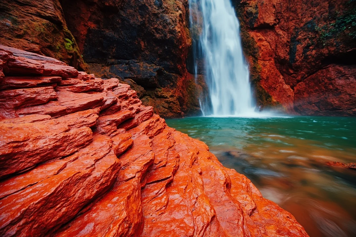
The falls tumble over Grinnell Argillite, an ancient sedimentary rock that contains iron oxide. This iron gives the rock its distinctive deep red and burgundy colors that seem to glow in the right light conditions.
During my visit last July, I arrived just as the morning sun started hitting the falls directly. The rocks transformed from a muted maroon to an almost luminous crimson, and the white water contrasting against that backdrop created perfect natural color harmony.
The waterfall itself drops approximately 30 feet in a series of cascades. It’s not going to compete with the height of Morrell Falls or the raw power of Kootenai Falls, but that’s not the point here.
Getting to the Trailhead: Many Glacier Logistics
Let me be direct about something that catches many first-time visitors off guard: getting to Many Glacier and securing parking is often more challenging than the actual hike.
The Many Glacier Road stretches about 12 miles from Babb to the Swiftcurrent Motor Inn area where most trailheads begin. During my most recent summer visit, the parking lots were completely full by 7:30 AM on a Saturday.
Parking Strategy That Actually Works
When I was there last summer, I learned the hard way that showing up at 9 AM means you’re either waiting for someone to leave or driving back to find alternative solutions. Here’s what I recommend based on what actually worked:
Arrive at the Swiftcurrent parking area before 7 AM during July and August. If that lot is full, the Grinnell Glacier trailhead lot sometimes has spaces since those hikers start even earlier.
The park has implemented a vehicle reservation system for some areas during peak season. Check the National Park Service website before your trip to see if Many Glacier requires reservations for your intended dates.
If you’re staying at the Many Glacier Hotel or Swiftcurrent Motor Inn, you avoid parking stress entirely. I recommend booking these properties 6-8 months in advance for summer dates.
Driving Directions From Key Locations
| Starting Point | Distance | Drive Time | Route Notes |
|---|---|---|---|
| St. Mary Visitor Center | 21 miles | 35 minutes | North on US-89, west on Many Glacier Road |
| Babb, Montana | 12 miles | 25 minutes | West on Many Glacier Road only |
| East Glacier Park | 45 miles | 1 hour 10 minutes | US-2 to US-89, then Many Glacier Road |
| Kalispell | 95 miles | 2 hours 15 minutes | US-2 to Going-to-the-Sun Road or US-89 |
The Many Glacier Road is paved but narrow with some curves. Watch for wildlife—I’ve seen bears, moose, and bighorn sheep on this road multiple times.
The Hike to Redrock Falls: Step-by-Step Trail Guide
The trail to Redrock Falls is one of the more straightforward hikes in Glacier National Park, making it accessible for families and casual hikers while still delivering genuine backcountry scenery.
Trail Statistics
- Distance: 3.6 miles round trip
- Elevation Gain: Approximately 300 feet
- Trail Type: Out and back
- Difficulty: Easy to moderate
- Average Hiking Time: 2-3 hours round trip
- Trailhead: Swiftcurrent Pass Trailhead
Starting Your Hike
The Swiftcurrent Pass Trail begins near the ranger station at the far end of the Swiftcurrent Motor Inn parking area. Look for the large wooden trailhead sign—you can’t miss it.
The first section of trail passes Fishercap Lake, a small but photogenic body of water about 0.3 miles from the trailhead. I recommend pausing here briefly, especially in early morning when mist sometimes hovers over the surface.
The trail is wide and well-maintained through this section, perfect for hiking side-by-side with a companion. When I brought my nephew here last summer, his 8-year-old legs handled this opening stretch with zero complaints.
Through the Willow Flats
Between miles 0.5 and 1.2, you’ll traverse an open area of willow bushes and meadows. This is prime moose habitat—I’ve encountered moose here on three separate occasions.
Keep your distance from any wildlife, but especially moose. They’re less predictable than bears in my experience, and cows with calves can be particularly defensive.
The mountain views through this section are outstanding. Mount Wilbur and Swiftcurrent Mountain dominate the skyline ahead, and on a clear day, you can see the hanging glaciers clinging to the upper reaches.
Entering the Forest
Around mile 1.2, the trail enters a more forested section with spruce and fir trees providing welcome shade on hot afternoons. The grade increases slightly here, but nothing that should cause difficulty for reasonably fit hikers.
This forested section reminded me of hiking toward Grotto Falls in Hyalite Canyon—that same hushed atmosphere where your footsteps on packed dirt become the loudest sound.
Listen for Redrock Creek before you see it. During my June visit when snowmelt was still in full force, I could hear the rushing water from nearly a quarter mile away.
Arriving at the Falls
The spur trail to Redrock Falls branches off the main Swiftcurrent Pass Trail about 1.8 miles from the trailhead. It’s marked with a small sign, though during my most recent visit, vegetation had partially obscured it.
The spur trail descends briefly through some rocky terrain before opening up to the falls viewpoint. Take your time on this descent—the rocks can be slippery when wet.
When I emerged from the trees and saw the falls for the first time, my immediate reaction was surprise at how intimate the setting felt. Unlike some Glacier waterfalls that you view from a distance, Redrock Falls allows you to get close enough to feel the spray on your face.
Best Time to Visit Redrock Falls
Timing matters significantly for experiencing Redrock Falls at its best. I’ve visited during different months and seasons, and each offers something different.
Peak Flow: June Through Early July
If waterfall volume is your priority, plan your visit between mid-June and early July. This is when snowmelt from the surrounding peaks creates maximum water flow.
During my June visit, the falls were absolutely thundering. The spray reached the viewing area, and the sound made normal conversation difficult. The downside? The trail can be muddy and some stream crossings might be tricky.
Optimal Conditions: Late July Through August
For the best combination of good weather, reasonable crowds, and sufficient water flow, I recommend late July through mid-August. The falls won’t be quite as dramatic, but the hiking conditions are superior.
This is also when wildflowers peak in the meadows along the trail. On my August visit, I counted at least fifteen different flowering species, including Indian paintbrush, beargrass, and glacier lilies.
Fall Colors: September
The larch trees in the Many Glacier valley turn brilliant gold in late September, creating a completely different atmosphere. Water flow diminishes significantly by this point, but the landscape photography opportunities improve.
Many Glacier Road typically closes for the season in late October or early November, depending on weather conditions. Check with the park before planning late-season visits.
Time of Day Considerations
The falls face roughly east, which means morning light creates the most vibrant colors on the red rocks. During my July visit, the sweet spot was between 8 AM and 10 AM when direct sunlight illuminated the argillite without creating harsh shadows.
Afternoon visits work fine but expect the rocks to appear more muted. Evening light can create some interesting effects as the sun dips behind the western peaks.
What to Bring: My Tested Packing List
After multiple trips to Redrock Falls across different conditions, I’ve refined my packing list to include what actually matters.
Essential Items
- Bear spray: Non-negotiable in Glacier. Make sure it’s accessible, not buried in your pack.
- Water: Minimum 2 liters per person. The trail has no reliable water sources until you reach Redrock Creek.
- Layers: Even on warm summer days, morning starts can be cool and weather changes quickly.
- Sturdy footwear: Trail running shoes work fine in dry conditions, but I prefer hiking boots for the rocky sections.
- Sunscreen and sunglasses: The open meadow sections offer no shade.
- Snacks: For a 2-3 hour hike, simple energy bars and fruit work well.
Photography Gear Recommendations
The red argillite creates both opportunities and challenges for photography. Here’s what worked during my visits:
A polarizing filter helps reduce glare on wet rocks and enhances the red colors. I noticed about a 20% improvement in color saturation with my polarizer attached.
If you want silky water effects, bring a neutral density filter and a small travel tripod. The viewing area provides stable footing for long exposures.
My 24-70mm lens covered everything I needed. You don’t need extreme telephoto or wide-angle for this waterfall.
Extending Your Hike: Combination Options
Redrock Falls works beautifully as a standalone destination, but the trail network in the Many Glacier area offers excellent options for extending your adventure.
Adding Bullhead Lake
Continuing past the Redrock Falls junction, the main trail reaches Bullhead Lake in another 1.2 miles. This adds about 2.5 miles round trip to your total distance.
Bullhead Lake sits in a dramatic cirque beneath Mount Wilbur. I found it significantly less crowded than nearby Swiftcurrent Lake or Grinnell Lake, despite being equally beautiful.
The additional elevation gain is minimal—maybe another 200 feet. When I continued to Bullhead Lake last summer, the total hike felt appropriately challenging without being exhausting.
The Full Swiftcurrent Pass Loop
For experienced hikers seeking a full day adventure, consider the complete Swiftcurrent Pass Trail, which climbs to an alpine pass at 7,185 feet before connecting with the Highline Trail.
This transforms the casual Redrock Falls hike into a strenuous 12+ mile day. I recommend this option only for fit hikers who start early and carry adequate supplies.
The views from Swiftcurrent Pass are among the best in the park, with glacial valleys spreading out in multiple directions.
Combining With Other Many Glacier Waterfalls
The Many Glacier area contains several waterfalls worth visiting. If you have multiple days, consider combining Redrock Falls with these nearby options:
Rockwell Falls lies along the Piegan Pass Trail and offers a completely different character—more of a rushing cascade through a narrow gorge.
For a more challenging excursion, Piegan Falls rewards the extra effort with a truly alpine setting.
Wildlife Safety and Awareness
Many Glacier is one of the most wildlife-rich areas in the lower 48 states. During my various visits, I’ve seen grizzly bears, black bears, moose, mountain goats, bighorn sheep, and numerous smaller creatures.
Bear Safety Essentials
This isn’t a section to skim. Grizzly bears are common in the Many Glacier valley, and the willow flats you traverse are prime foraging habitat.
Carry bear spray and know how to use it before you need it. I practice deploying my spray (without actually firing it) at the beginning of each hiking season.
Make noise while hiking, especially in areas with limited visibility. I don’t love the sound of bear bells, but they work. Talking, clapping, and calling out “hey bear” at regular intervals also helps.
Hike in groups when possible. Bears rarely approach groups of four or more people.
If You Encounter a Bear
Stay calm. Don’t run—this can trigger a chase response.
For grizzlies, speak in calm tones, avoid eye contact, and slowly back away while facing the bear. If it charges, use your bear spray when it’s within 30 feet.
For black bears, which are less common in this area but still present, make yourself appear larger and maintain eye contact.
Moose Encounters
Moose might seem less intimidating than bears, but they injure more people in North America than bears do. The willow flats along the Redrock Falls trail are classic moose habitat.
Keep at least 75 feet of distance. If a moose begins showing signs of agitation—pinned ears, raised hackles, lip-licking—back away immediately.
I once had a cow moose emerge from willows about 40 feet away while hiking this trail. I simply backed up slowly, gave her space, and waited about ten minutes before continuing. No drama, but my heart rate definitely increased.
The Geology That Makes This Place Special
Understanding the geology of Redrock Falls enhances the experience significantly. These aren’t just pretty rocks—they’re windows into deep time.
1.5 Billion Years of History
The red argillite at Redrock Falls formed during the Precambrian era, long before complex life existed on Earth. These sedimentary rocks originated as mud deposited in shallow seas and were later transformed through heat and pressure.
The distinctive red color comes from iron oxide—essentially rust—that formed when iron-rich minerals oxidized in the ancient shallow marine environment.
When I sat beside the falls during my last visit, I tried to conceptualize 1.5 billion years. The dinosaurs wouldn’t arrive for another 1.3 billion years. The rocks beneath my feet predated most of the tree of life.
Why Here and Not Everywhere?
Glacier National Park contains various Belt Supergroup rocks, but the vivid red argillite is concentrated in specific areas. The Many Glacier valley and parts of the eastern park expose these colorful formations prominently.
Similar rocks appear at Running Eagle Falls in the Two Medicine area, though the colors there are slightly different due to variations in mineral content.
Practical Information for Planning Your Visit
Let me consolidate the essential planning details you’ll need.
Park Entrance and Fees
Redrock Falls is located within Glacier National Park. As of my most recent visit, entrance fees were:
- Private vehicle (7-day pass): $35
- Motorcycle (7-day pass): $30
- Individual (foot/bicycle, 7-day pass): $20
- Annual Pass: $70
- America the Beautiful Pass: $80 (covers all federal lands)
If you’re planning to visit multiple Montana waterfalls, the America the Beautiful Pass quickly pays for itself. It covers entrance to other prime waterfall destinations like those near Ousel Falls in Bozeman’s surrounding national forest areas.
Facilities at the Trailhead
The Swiftcurrent area has vault toilets near the parking lot but no running water at the trailhead itself.
The Swiftcurrent Motor Inn offers a small camp store with basic supplies, snacks, and drinks. Hours vary seasonally—during my July visit, it opened at 7 AM.
For more substantial meals, the Many Glacier Hotel’s Ptarmigan Dining Room serves breakfast, lunch, and dinner during the summer season.
Cell Phone Coverage
Expect no cell coverage at the trailhead or along the trail. I’ve had occasional weak signals at the Many Glacier Hotel, but don’t count on being connected.
Download offline maps before arriving. I use the Gaia GPS app with downloaded Glacier National Park maps for all my hikes in the park.
Accessibility Notes
The trail to Redrock Falls is not wheelchair accessible. The packed dirt surface with roots, rocks, and moderate grades presents barriers for mobility devices.
Visitors with limited mobility might consider the shorter walk to Fishercap Lake (about 0.3 miles one way), which follows the flattest portion of the trail.
Nearby Accommodations and Camping
Where you sleep affects your experience, especially regarding that crucial early morning parking situation.
Inside the Park
Many Glacier Hotel: This historic Swiss-style lodge sits on the shore of Swiftcurrent Lake. It’s expensive ($250-400/night during peak season) but eliminates parking stress entirely.
Swiftcurrent Motor Inn: More affordable rustic cabins and motel units. Still pricey by normal standards ($150-250/night) but reasonable for national park lodging.
Many Glacier Campground: The 109-site campground accepts reservations and is the most affordable option ($23/night during my last visit). Sites fill months in advance for summer dates.
Book any of these options as far ahead as possible. When I planned my August trip, I made reservations in January.
Outside the Park
The town of Babb offers several lodging options about 12 miles from the trailhead. These tend to be slightly less expensive than in-park options.
St. Mary provides additional choices and sits about 35 minutes from Many Glacier. The KOA campground there offers good amenities for those who want hot showers and laundry.
Making the Most of Your Many Glacier Visit
If you’ve driven all the way to Many Glacier—and it is a drive—maximize your time there.
Multi-Day Itinerary Suggestion
Day 1: Arrive early, secure parking, hike to Redrock Falls and optionally continue to Bullhead Lake. Spend the afternoon exploring the lake shore near Many Glacier Hotel.
Day 2: Tackle the classic Grinnell Glacier hike (11 miles round trip) or the Iceberg Lake trail. Both start from the same general area.
Day 3: Sleep in slightly, then take the boat tour across Swiftcurrent Lake and Lake Josephine for different perspectives on the valley.
This itinerary lets you experience the full range of what Many Glacier offers while avoiding repetitive early mornings.
Other Waterfall Day Trips From Many Glacier
If you’re a dedicated waterfall chaser, consider day trips to other Glacier waterfalls from your Many Glacier base:
McDonald Falls on the west side of the park offers a completely different forest ecosystem experience.
The Sacred Dancing Cascade along Going-to-the-Sun Road provides easy roadside access to a beautiful cascade.
For something more adventurous, the hike to Ipasha Falls delivers backcountry solitude.
Honest Assessment: Is This Hike Worth It?
After multiple visits, I can give you a nuanced answer.
Redrock Falls Is Perfect For:
- Families with children who can walk 3-4 miles
- Photographers interested in unique geology
- Hikers wanting a shorter option in Many Glacier
- Anyone combining it with nearby destinations like Bullhead Lake
- Geology enthusiasts and rock hounds
It May Not Be Right For:
- Hikers who prioritize dramatic waterfall height over unique character
- Those unable to reach Many Glacier early enough for parking
- Visitors looking for challenging terrain
Compared to other Montana waterfalls I’ve visited, Redrock Falls ranks high for uniqueness but moderate for sheer impressiveness. The red argillite creates an atmosphere unlike any other waterfall in the state.
If you’re only visiting one Many Glacier destination and want a waterfall, I’d actually suggest combining Redrock Falls with Bullhead Lake for a more complete experience. But if geological curiosity drives your hiking choices, Redrock Falls alone justifies the trip.
For those building a comprehensive Montana waterfall bucket list, I’d also recommend experiencing Memorial Falls near Great Falls for its historical significance, Holland Lake Falls in the Seeley-Swan Valley for easy accessibility, and Palisade Falls near Bozeman for dramatic vertical drop.
Final Thoughts From the Trail
On my most recent trip to Redrock Falls, I arrived at the viewing area just as another hiker was leaving. For about twenty minutes, I had the falls entirely to myself.
I sat on a flat section of that ancient red rock, felt the cool mist on my face, and listened to water that had been snowpack just days before. The mountains rose behind me, the falls cascaded before me, and I experienced that particular stillness that comes from being alone in a wild place.
That moment captures why I keep returning to Glacier National Park and why specific destinations like Redrock Falls matter. It’s not about superlatives or checking boxes. It’s about finding places where geology, water, light, and silence combine into something memorable.
Whether you visit Redrock Falls as a quick morning hike or as part of an extended Many Glacier exploration, come prepared, start early, and give yourself time to simply be present with these 1.5-billion-year-old rocks and the water dancing over them.
The falls will be there, cascading over crimson stone, long after we’re all gone. Witnessing them feels like a privilege worth a few hours of hiking.
Frequently Asked Questions
Where is Redrock Falls located in Montana and how do I get there?
Redrock Falls is located in Glacier National Park’s Many Glacier region, about 12 miles west of Babb, Montana. To reach the trailhead, drive to the Swiftcurrent Motor Inn parking area and follow the Swiftcurrent Pass Trail for approximately 1.8 miles one way. I found the trail well-marked and relatively easy to navigate, though you’ll need a park entrance pass ($35 per vehicle for 7 days).
How difficult is the Redrock Falls hike and is it suitable for beginners?
The Redrock Falls hike is considered easy to moderate, with minimal elevation gain of around 200 feet over 1.8 miles. I’d recommend this trail for beginners and families with children who have some hiking experience. The path is well-maintained and offers stunning views of the surrounding peaks, making the effort well worth it for hikers of most fitness levels.
What is the best time of year to visit Redrock Falls Montana?
The best time to visit Redrock Falls is mid-June through mid-September when the trail is snow-free and fully accessible. I prefer visiting in late June or early July when snowmelt makes the waterfall most powerful and impressive. Keep in mind that the Many Glacier Road typically doesn’t open until late May due to snow, so always check current road conditions before planning your trip.
What should I bring on the Redrock Falls hike in Glacier National Park?
Bring bear spray (rentals available in the park for around $10/day), plenty of water, sturdy hiking shoes, and layered clothing since mountain weather changes quickly. I always pack a rain jacket even on sunny days and carry snacks for the trail. Don’t forget your camera—the views of Grinnell Point and Mount Wilbur along the way are spectacular.
Can I see wildlife near Redrock Falls and what precautions should I take?
The Many Glacier area is one of the best spots in Montana for wildlife viewing, and I’ve personally spotted moose, bighorn sheep, and grizzly bears near Redrock Falls. Always hike in groups, make noise on the trail, and keep bear spray accessible—not buried in your backpack. Maintain at least 100 yards distance from bears and wolves, and 25 yards from other wildlife.
Is there an entrance fee for Redrock Falls and do I need a reservation?
Yes, you’ll need a Glacier National Park entrance pass ($35 per vehicle, $20 per motorcycle, or $80 for an annual pass). During peak summer months (late May through early September), you’ll also need a timed vehicle reservation to enter the Many Glacier area, which costs an additional $2 per reservation. I recommend booking reservations at Recreation.gov as soon as they become available since they sell out quickly.
Are there other waterfalls near Redrock Falls worth visiting on the same trip?
Absolutely—if you continue past Redrock Falls another 0.4 miles, you’ll reach Bullhead Lake, and the same trailhead provides access to Grinnell Lake and its stunning glacial waters. I suggest combining Redrock Falls with nearby Swiftcurrent Falls, which is just a short walk from the parking area and requires no hiking. This makes for a perfect full-day waterfall adventure in the Many Glacier valley.
Sources: