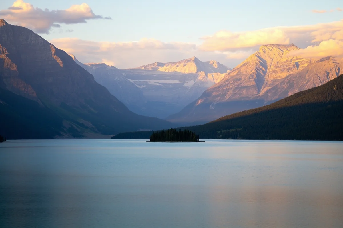
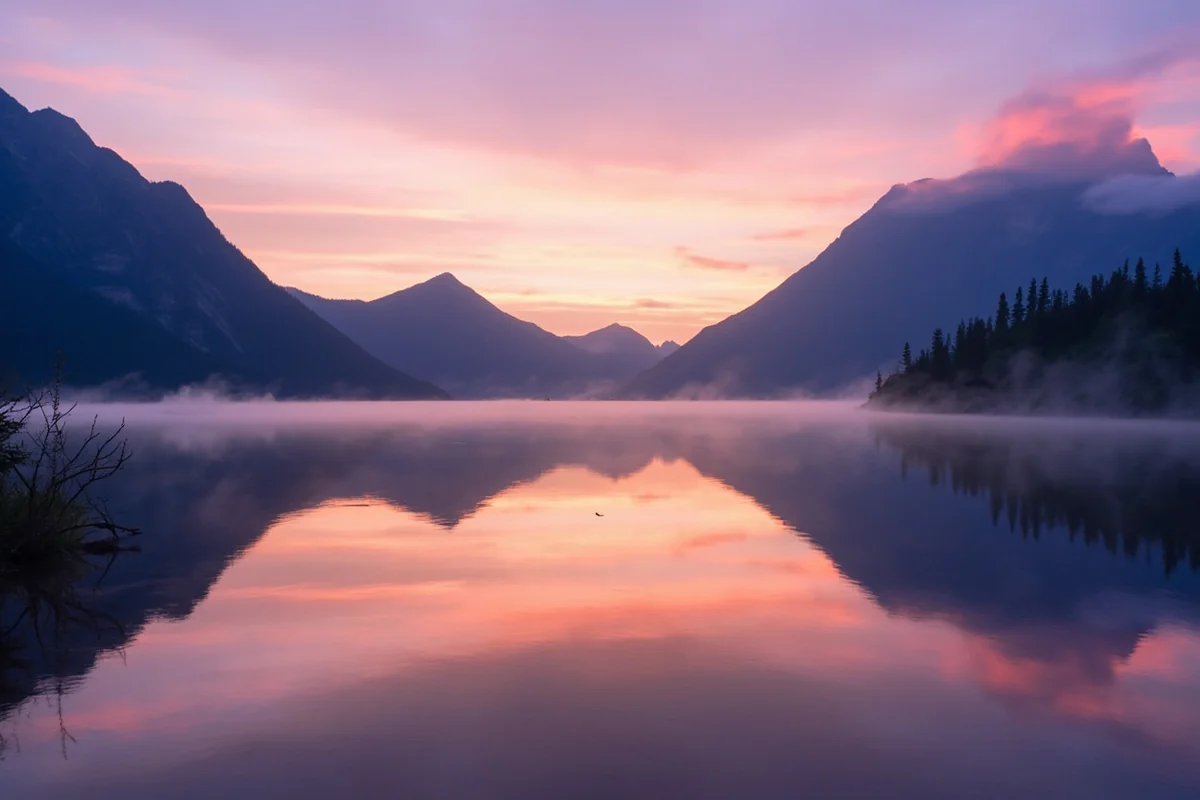
I’ve set an alarm for 5:30 a.m. more times than I can count just to catch the light hitting Wild Goose Island before the wind picks up on St. Mary Lake. That window is short — sometimes twenty minutes — and I’ve learned the hard way that this lake does not wait for you to get your tripod set up.
St. Mary Lake is Glacier National Park’s second-largest lake, on the drier, windier east side of the Continental Divide. This guide covers the famous Wild Goose Island viewpoint, the boat tour that gets you out on the water, hiking trailheads along the shoreline, and the wind patterns that catch almost every first-time visitor off guard.
St. Mary Lake by the Numbers
- Length: approximately 9.9 miles (roughly 10 miles)
- Maximum depth: approximately 292 feet
- Elevation: about 4,484 feet, notably higher than Lake McDonald
- Location: on the east side of the Continental Divide, within the drier Blackfeet Nation border region
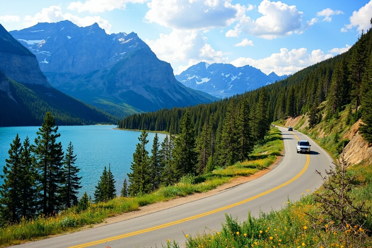
The lake’s north shore is closely followed by Going-to-the-Sun Road on its climb toward Logan Pass. Because St. Mary sits on the leeward, east side of the Divide, it gets a fraction of the precipitation that Lake McDonald’s west-side basin receives.
The tradeoff is wind — the same mountains that block rain and snow from the Pacific side funnel and accelerate wind coming down from the high peaks, and St. Mary Lake has a well-earned reputation as one of the windiest spots in the entire park.
Wild Goose Island
The single most photographed frame on this lake — and arguably in the whole park — is the view of tiny, forested Wild Goose Island from the pullout along Going-to-the-Sun Road, with the lake stretching behind it toward a wall of peaks including Fusillade Mountain and Little Chief Mountain.
I’ve shot this view in fog, in full sun, and once in a light snow in early June, and it’s never once looked the same twice.
The catch: this pullout is small, popular, and often crowded from mid-morning through evening in summer. I’ve had the best luck arriving right around sunrise, both for the light and because the parking area is nearly empty at that hour.
The Wind Problem (And How to Work Around It)
St. Mary Lake’s wind isn’t an occasional inconvenience — it’s a defining feature of the place.
Afternoon gusts here regularly reach speeds that make small boats and kayaks genuinely unsafe, and I’ve watched the boat tour operator cancel afternoon trips more than once due to conditions that looked, from shore, only moderately breezy.
My rule after years of visiting: plan any time-sensitive activity on this lake — photography, kayaking, boat tours — for the morning, ideally before 10 a.m.
If you only have an afternoon slot available, have a backup plan (a hike, a drive further along Going-to-the-Sun Road) in case wind cancels your original plan.
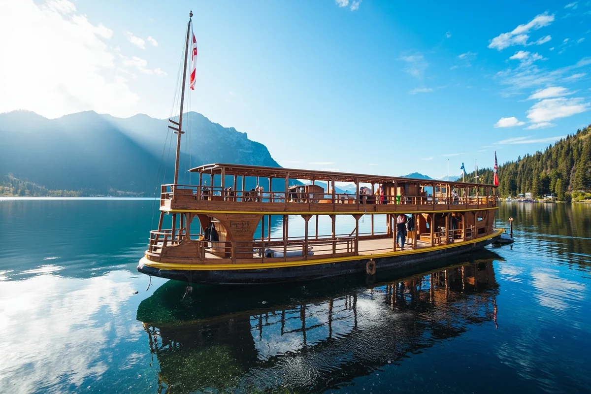
Boat Tours on St. Mary Lake
A historic wooden tour boat operates on St. Mary Lake in summer, launching from the dock near Rising Sun, and it’s genuinely one of the better ways to see the lake if you’d rather not fight the wind in a kayak.
The tour typically includes a ranger-led talk and a stop for a short guided hike partway through, weather permitting. I’d book this in advance during peak season [verify current schedule and pricing], since capacity is limited and trips do get canceled outright on high-wind days.
Hiking Around St. Mary Lake
The lake anchors several worthwhile trailheads:
- St. Mary Falls and Virginia Falls — a moderate trail from the Sunrift Gorge or St. Mary Falls trailhead, popular enough that I’d recommend an early start in peak summer.
- Sun Point — a short walk with expansive lake views, good for visitors with limited time or mobility.
- Baring Falls — an easy add-on near the St. Mary Falls trail, often combined into the same outing.
For a broader trail overview across the whole park, see my Glacier National Park hiking guide.
Fishing St. Mary Lake
The lake holds lake trout and whitefish, though fishing pressure here is lighter than at Lake McDonald, partly because of the wind and partly because St. Mary simply gets less attention from anglers overall. A free Glacier National Park fishing permit covers fishing here, same as elsewhere in the park.
Camping and Lodging Near St. Mary Lake
Rising Sun Campground, on the lake’s north shore, puts you closest to the water and the boat tour dock. St. Mary Campground, near the park’s east entrance, is larger and closer to services in the town of St. Mary just outside the park boundary.
For indoor lodging, the Rising Sun Motor Inn sits right along the lakeshore, while the town of St. Mary has a wider range of motels and cabins just outside the entrance gate.
See my full Glacier National Park lodging guide for more options across the park.
Sunrift Gorge and Baring Falls
A short, easy walk from a small pullout along the road near the lake’s south end leads to Sunrift Gorge, a narrow slot carved into the rock by Baring Creek, and continues on to Baring Falls just beyond it.
I usually treat this as a five-minute detour worth taking even on a day with limited time, since it requires almost no extra effort but adds a genuinely different landscape — narrow, mossy, and shaded — to a day otherwise spent in open, windswept terrain.
Wildlife Around the Lake
The drier, more open terrain on this side of the park supports more visible bighorn sheep and mountain goat activity than the forested west side, particularly on the slopes above Sun Point and Sunrift Gorge.
I’ve also had regular sightings of black bears foraging near the lower trailheads in berry season, and this is prime grizzly country as well — standard bear-aware practices apply on every trail here.
The Name and the History
St. Mary Lake sits just west of the Blackfeet Nation reservation boundary, and the surrounding land and its history are deeply tied to the Blackfeet people, who have inhabited this region for centuries before the park’s establishment in 1910.
The lake’s English name dates to 19th-century missionary activity in the area, though it carries older names and significance in Blackfeet tradition tied to the surrounding landscape.
I’d encourage visitors to spend some time at the Native America Speaks program, offered by park rangers and Blackfeet cultural interpreters at campground amphitheaters on this side of the park in summer — it’s added real depth to my understanding of the place every time I’ve attended.
The town of St. Mary, just outside the park’s east entrance, grew up around this history and the tourism traffic that followed Going-to-the-Sun Road’s completion in 1932-33.
Unlike the more forested, resort-feeling development on the west side near West Glacier, St. Mary retains a smaller, more exposed, high-plains-meets-mountains feel that I think suits the lake’s own windswept character.
Comparing St. Mary Lake to Glacier’s Other Lakes
I get asked often whether visitors should prioritize St. Mary or Lake McDonald if they only have time for one. My honest take: if you’re choosing based on photography and that classic “big sky over big water” feel, St. Mary and its Wild Goose Island view are hard to beat.
If you’re choosing based on comfort — swimming, calmer boating, more sheltered hiking — Lake McDonald’s west-side location wins.
Many visitors doing the full Going-to-the-Sun Road drive see both in the same day anyway, since the road connects them directly over Logan Pass, which is the itinerary I’d recommend if your schedule allows it.
Compared to the park’s smaller alpine lakes like Grinnell or Two Medicine, St. Mary is far more accessible by car, which is exactly why it draws bigger crowds at its main pullouts even as the lake’s overall shoreline sees less foot traffic than, say, Lake McDonald’s trail-heavy south side.
Extending the Boat Tour Experience
Beyond the standard narrated tour, the St. Mary boat trip typically includes a stop that lets passengers disembark for a short, ranger-guided walk before returning to the dock — I’ve found this to be one of the better low-effort ways to get a sense of the lake’s ecology and history without committing to a full hiking day.
Because the boat is a historic wooden vessel, part of a small fleet still operating on several of the park’s lakes, there’s also a bit of maritime history built into the ride itself if you ask the crew about it, which I always do.
Personal Tips / What I Wish I Knew
Go for sunrise, not sunset, at Wild Goose Island. The wind is almost always calmer in the early morning here, which means better reflections and a better shot at the classic view.
Layer up regardless of the forecast. I’ve been sunburned and windburned on the same afternoon at this lake. The wind cuts through light clothing fast even on warm days.
The east side feels like a different park. After time on the lush, forested west side around Lake McDonald, the open, wind-scoured terrain around St. Mary genuinely feels like crossing into a different ecosystem — because, climatically, it is.
Check the boat tour status before building your day around it. Wind cancellations happen often enough that I never plan a whole morning around the boat tour without a backup activity in mind.
Getting There
Most visitors reach St. Mary Lake either by driving Going-to-the-Sun Road over Logan Pass from the west side, or by entering directly through the park’s St. Mary entrance on the east side via US Highway 89.
If you’re coming from Great Falls, the drive to the St. Mary entrance takes a little over two hours; from Kalispell or the west entrance, plan on the better part of a day if you’re also stopping at overlooks along the way over the pass, which I’d genuinely recommend rather than treating the drive as a means to an end.
The town of Browning, on the Blackfeet Nation, sits about 30 minutes east and makes a good stop for gas, food, and cultural sites on your way in or out.
I’d also point out that early fall is an underrated window here — see my Montana in September guide for what to expect if you’re weighing a shoulder-season visit against the deeper crowds of July and August.
Practical Info: St. Mary Lake
| Best season to visit | Mid-June through September for full road and facility access |
| Wind | Frequent and strong, especially afternoons; mornings are calmer |
| Boat tours | Seasonal, departing from Rising Sun dock [verify current schedule] |
| Fishing permit | Free Glacier National Park fishing permit required |
| Camping | Rising Sun Campground (lakeside) and St. Mary Campground (near east entrance) |
| Nearest town | St. Mary, MT, just outside the park’s east entrance |
Frequently Asked Questions
Why is St. Mary Lake so windy?
The lake sits on the east side of the Continental Divide, where mountains funnel and accelerate wind coming down from the high peaks, creating consistently stronger afternoon winds than the more sheltered west side of the park.
How deep is St. Mary Lake?
St. Mary Lake reaches a maximum depth of approximately 292 feet.
What is Wild Goose Island?
A small, forested island near the center of St. Mary Lake, visible from a popular roadside pullout on Going-to-the-Sun Road and one of the most photographed views in the National Park System.
Is St. Mary Lake bigger than Lake McDonald?
No. Lake McDonald is the park’s largest lake at about 10 miles long and nearly 500 feet deep; St. Mary is the second-largest.
Can you swim in St. Mary Lake?
Swimming is permitted, but the combination of cold water, wind, and choppy conditions makes it far less popular for swimming than Lake McDonald.
Why is it called St. Mary Lake?
The English name dates to 19th-century missionary activity in the region; the lake and surrounding landscape also carry significance in Blackfeet tradition, whose reservation borders the park just east of here.
Is St. Mary Lake or Lake McDonald better to visit?
It depends on priorities — St. Mary offers dramatic open views and the Wild Goose Island photo, while Lake McDonald offers calmer water, more swimming and boating comfort, and more forested trail access. Many visitors see both in one day via Going-to-the-Sun Road.
What town is closest to St. Mary Lake?
The small town of St. Mary, Montana, sits just outside the park’s east entrance, a short drive from the lake’s eastern shore.
Final Thoughts
St. Mary Lake taught me to stop assuming every lake in Glacier behaves the same way. The wind here is genuinely part of the experience, not a footnote, and once I started planning around it instead of fighting it, this became one of my favorite parts of the park to photograph and hike.
For more of Glacier’s lakes, see my guide to Lake McDonald, and for the full regional picture, check out the complete guide to Montana’s best lakes.