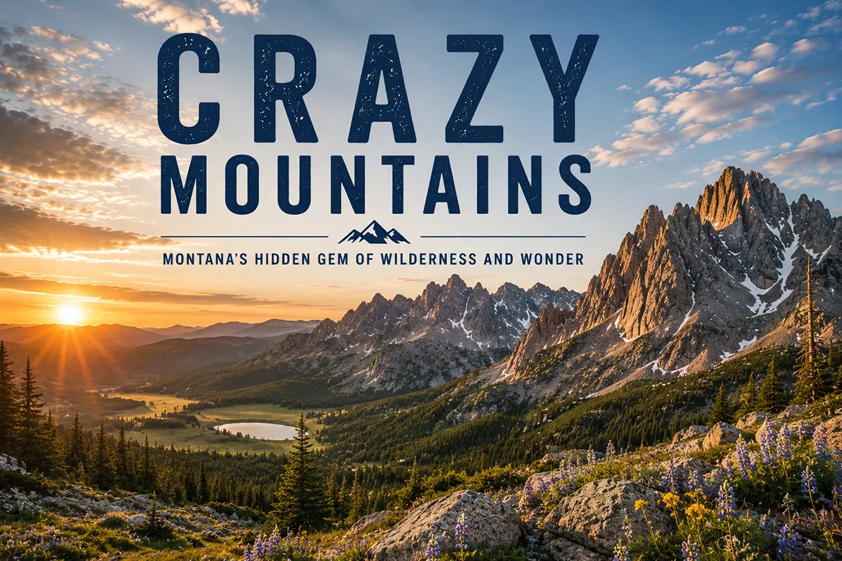
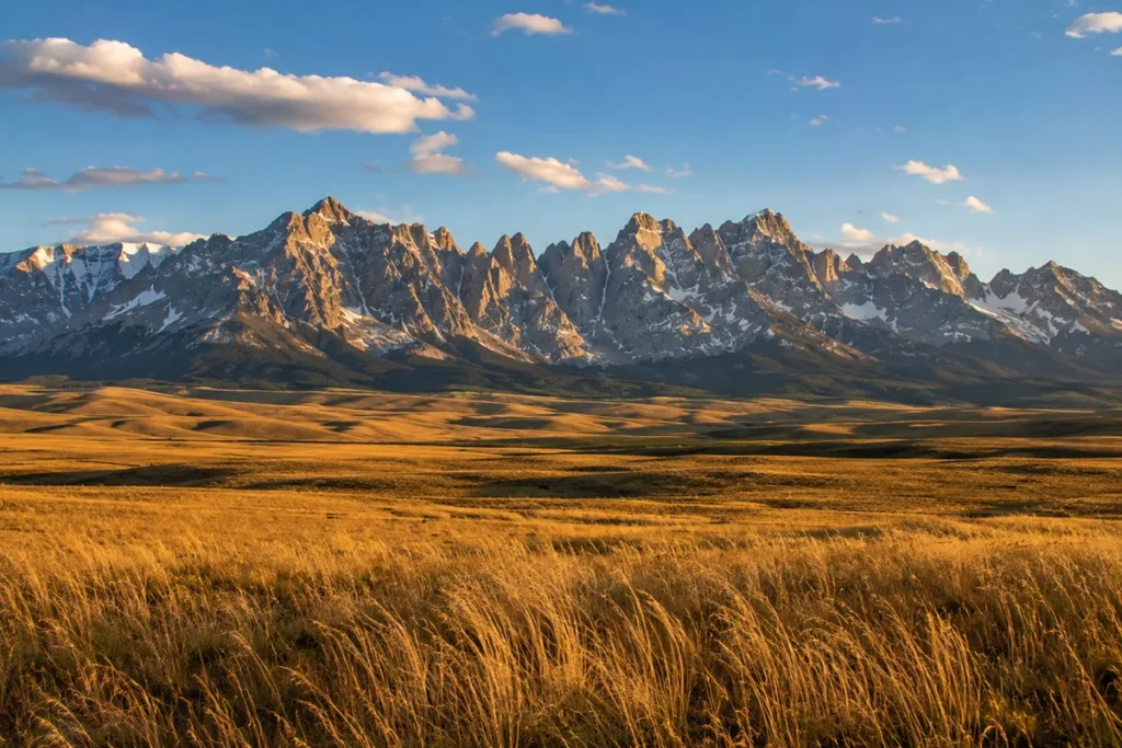
The first time you see the Crazy Mountains, you almost don’t believe them. You’re driving east on I-90 past Big Timber, you’ve been looking at flat prairie for two hours, and suddenly there’s a wall of 11,000-foot jagged peaks standing in the middle of it with absolutely nothing connecting them to anything else. It looks like someone airlifted a chunk of the Tetons and dropped it in the wrong place.
The Crazy Mountains are Montana’s most dramatic island range — a 40-mile-long cluster of granite peaks rising abruptly from the plains between Big Timber and Harlowton. Crazy Peak (11,214 ft) is the most topographically prominent peak in the state, rising over 7,000 feet above the surrounding prairie. The range is sacred to the Apsaalooke (Crow) people, who call it Awaxaawapia Pia — the Ominous Mountains. Access has been complicated for a century by checkerboard public-private land ownership, but the January 2025 East Crazy Inspiration Divide Land Exchange consolidated public land and created clearer trail access — though the deal is controversial. This guide covers what’s currently accessible, where to base yourself, and what to expect on the ground.
What Makes the Crazies an “Island Range”
Most Montana mountain ranges are part of a larger chain. The Beartooths connect to the Absarokas. The Bitterroots run continuously into Idaho.
The Gallatins and Madisons are tied into the Greater Yellowstone Ecosystem. They’re all sub-ranges of the Northern Rockies, connected by ridgelines and passes.
The Crazies aren’t. They stand alone — 40 miles long, 15 miles wide, completely surrounded by prairie on all four sides.
The nearest “real” mountains are the Bridgers (40 miles southwest) and the Absarokas (50 miles south). Between them and the Crazies is nothing but rolling grassland and the Yellowstone River. This isolation is the result of how the range formed.
Around 50 million years ago, an enormous body of molten rock — geologists call it the Big Timber Stock — intruded up into the existing sedimentary layers from below, creating a roughly 600-square-mile dome of igneous rock that never quite reached the surface as lava.
The softer sedimentary rock around it eroded away. The harder igneous rock didn’t.
Fifty million years later, the dome is what’s still standing, with its peaks exposed and jagged, surrounded by the eroded plains. The Crazies are essentially a fossilized magma chamber. Geology is wild.
This pattern — an isolated mountain range rising from the plains — is what makes a range an “island range.” Montana has several others: the Sweet Grass Hills, the Bears Paw, the Big Snowy, the Highwood, the Little Rocky, and the Pryor Mountains.
But none of them rise as dramatically as the Crazies. For more context, see my full Montana mountain ranges guide.
Crazy Peak and the Prominence Record
Crazy Peak, at 11,214 feet, is the high point of the range and the most topographically prominent peak in Montana — meaning it rises more vertically above its surroundings than any other peak in the state, including Granite Peak in the Beartooths.
Its prominence is 5,719 feet, which puts it on the U.S. list of 100 most prominent peaks. From the plains directly east of the range, Crazy Peak looms over 7,000 feet above you.
I want to be straight about one thing here: Crazy Peak sits on private land. You cannot legally hike to the summit from the standard approach without crossing private property.
This is one of the long-running access frustrations of the Crazies, and even the 2025 land exchange didn’t entirely resolve it — though the agreement does include provisions for Crow Tribal members to acquire legal access to the peak as a sacred site.
For non-tribal hikers wanting to reach the top, the standard route still involves complicated land status, and you should check current conditions with the Custer Gallatin National Forest before you go.
The range has more than [verify 30] peaks above 10,000 feet, with other notable summits including Sunlight Peak, Conical Peak, and Iddings Peak. Most of these can be reached from public trailheads.
Awaxaawapia Pia: The Cultural Significance
To the Apsaalooke (Crow) people, the Crazies aren’t a tourist destination. They’re sacred ground.
The Crow name for the range is Awaxaawapia Pia — sometimes written Awaxaawippíia — usually translated as “the Ominous Mountains” or “the Mountains of Madness.” The name reflects the range’s role as a place of spiritual power.
The Crazies have been used as a vision-quest site for centuries: young Crow men would travel into the mountains alone, fast for four days, and seek visions and spiritual guidance from the powers said to inhabit the high country.
Crazy Peak itself is one of the most important vision-quest sites in Crow tradition. The English name “Crazy Mountains” appears to be a corruption of this.
The most-cited story involves a white settler woman who allegedly lost her mind in the mountains after her family was killed, but historians and ethnographers generally consider this story apocryphal — likely a folk explanation grafted onto a translation that didn’t quite work.
The original meaning, as the Crow understood it, was something closer to “mountains where powerful spirits dwell.” Calling them “Crazy” misses most of that.
This matters not just historically but practically: the 2025 land exchange explicitly includes provisions for Crow Tribal members to access Crazy Peak for cultural and ceremonial purposes — a recognition that the range’s significance extends beyond recreation.
For broader Montana indigenous history, see our Montana history overview.
The 2025 Land Exchange: What Changed and What It Means for Hikers
For nearly a century, the Crazies have been some of the most legally complicated mountain country in America.
The reason is checkerboard ownership — a 19th-century federal policy of granting alternate one-square-mile sections to railroad companies along right-of-ways, leaving the result of a chessboard of public and private parcels intermixed.
Trails crossed back and forth between public and private land. Some private landowners allowed access; others didn’t.
Some trails appeared on Forest Service maps but were physically blocked by gates. Lawsuits piled up. Hikers showed up at trailheads and got turned away.
That changed — partially, controversially — on January 17, 2025, when the Custer Gallatin National Forest finalized the East Crazy Inspiration Divide Land Exchange.
What the Deal Does
The exchange consolidated checkerboarded ownership on the east side of the range. In total:
- 3,855 acres of federal land were transferred to private ownership
- 6,110 acres of private land were transferred to public (federal) ownership
- Net public land gain: ~2,255 acres
- A new 22-mile public trail (the new East Trunk Trail / Sweet Trunk Trail) was constructed on consolidated public land, paid for by the Yellowstone Club, replacing a contested historic route
- The total roadless area in the east Crazies increased to roughly 94,590 acres
The deal also included a related component in the Madison Range near Big Sky — about 1,000 acres exchanged in the Inspiration Divide area.
What the Deal Is Criticized For
The exchange has been controversial. Wild Montana and several other access organizations argue that even with conservation easements built into the agreement, transferring nearly 4,000 acres of public land into private ownership — particularly with the Yellowstone Club as a major beneficiary — sets a problematic precedent.
Some local Montanans, including fifth-generation residents like Brad Wilson of Friends of the Crazy Mountains, have publicly opposed the deal, arguing it consolidates billionaire-owned private holdings in a sacred and historically public range.
Historic trails like the Sweet Grass Trail were excluded from the final exchange.
Supporters — including the Crazy Mountain Access Project, Park County Environmental Council, and the Crow Tribe — argue the deal secures permanent legal public access on the east side for the first time in over a century, ends the perpetual checkerboard confusion, and recognizes Crow cultural rights to Crazy Peak.
The deal is finalized but implementation is ongoing. As of 2026, the new East Trunk Trail is being constructed.
What This Means for Your Trip
For practical hiking purposes, the post-2025 reality is:
- East-side access is now consolidated to the Big Timber Creek trailhead at Halfmoon Campground. Other historic east-side trailheads have been eliminated or rerouted.
- West-side access remains via the Cottonwood Creek trailhead off Cottonwood Road north of Clyde Park.
- Always verify trail status with the Custer Gallatin National Forest ranger district before going — both because implementation is ongoing and because seasonal conditions vary.
- OnX Hunt or similar GPS layers showing current public-private boundaries are essential equipment in this range.
The Best Hikes in the Crazy Mountains
The Crazies have around 119 miles of trail across the range. Most of it is rough, lightly maintained, and steeper than equivalent miles in other ranges. Here are the hikes I’d send people to, in order of accessibility.
Twin Lakes (Big Timber Canyon Side)
This is the classic Crazies day hike. The trailhead at Halfmoon Campground at the end of Big Timber Canyon Road is the main public access on the east side.
The hike is roughly 8.5 miles round-trip with about 2,000 feet of gain, climbing through forest along Big Timber Creek before opening up at the two alpine lakes set against vertical granite walls.
This is what people come for. Plan to do it as a long day hike or an easy overnight backpack.
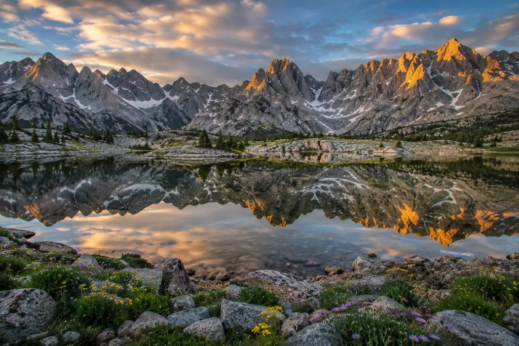
Twin Lakes is also the access point for further travel into the Crazies’ interior — Blue Lake, Granite Lake, Thunder Lake, and the high country beyond.
Blue Lake
From the Big Timber Creek trail, a junction at about 2.8 miles branches off to Blue Lake — another mile or so up. The combined Twin Lakes + Blue Lake trip is a great two-night backpack, hitting multiple high lakes from a single trailhead.
Cottonwood Lake (West Side)
The Cottonwood Creek trailhead provides west-side access. The trail to Cottonwood Lake climbs about 2,000 feet over six miles to a lake at 8,945 feet.
This is a strenuous day hike or an easier overnight. The west side generally sees fewer people than the east side.
Trespass Creek to Campfire Lake
For a longer, more committing route, the Trespass Creek trail crosses the main divide of the range from the west to Campfire Lake. About 10 miles one-way. This is genuine backcountry — expect to see no one.
The Crazy Mountains Traverse (Crossing)
The full range crossing — a multi-day point-to-point traverse from the east-side trailheads to the west, or vice versa — is one of Montana’s classic backcountry trips.
Three to five days, multiple high passes, no resupply, and you’ll need a shuttle. Best done in late July through August.
The new East Trunk Trail, once fully built out, will become part of an extended approximately 40-mile loop traversing the range.
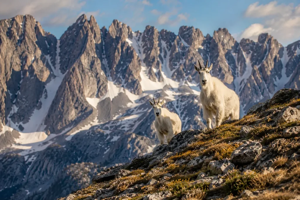
Wildlife in the Crazies
The Crazies are unusually wildlife-rich for an island range of their size.
Mountain goats — the range supports a population of approximately 450, one of the largest in Montana. Montana Fish, Wildlife & Parks considers the Crazies critical habitat for mountain goat persistence as climate pressure pushes the species upslope across its range.
Wolverines — the Crazies are repeatedly cited as having “the largest population of wolverines in the world,” a claim worth a little context. What’s actually documented is that the Crazies are a critical wolverine refugium with unusually high density given the range’s small footprint. The species is exceptionally rare, has enormous home ranges (300+ square miles per animal), and is hard to count, so absolute population numbers are murky. What’s true is that the Crazies are some of the best wolverine habitat in the Lower 48.
Elk, mule deer, and black bears are common. Grizzly bears are occasionally documented but not yet established as a resident population — though as the regional grizzly population expands, that may change. Carry bear spray regardless and review our Montana bear guide.
Golden eagles, mountain lions, and pikas round out the high-country fauna. The lower elevations support pronghorn out on the surrounding prairie.
Where to Base Yourself
The Crazies have five gateway towns, each with its own character. Here’s the honest comparison.
Big Timber — East-Side Basecamp
Best for: First-time visitors, classic Halfmoon Campground access, the iconic Twin Lakes/Blue Lake trail system.
Big Timber sits at the foot of the east face of the Crazies along I-90 and the Yellowstone River. Population around 1,600. The town has a few solid restaurants (the Grand Hotel restaurant is a local institution), a couple of motels, and direct gravel-road access up Big Timber Canyon to the Halfmoon trailhead. This is where I’d base if you’re doing the eastern hikes.
Livingston — Regional Basecamp
Best for: Travelers combining the Crazies with Yellowstone, the Paradise Valley, or the Absaroka Range.
Livingston is the larger, more developed town in the area — population around 8,000, with strong restaurants, the historic Murray Hotel, and serious fly fishing on the Yellowstone. It’s about 35 miles south of the Crazies. Not as quick to the trailheads as Big Timber, but a much better town for an evening.
Clyde Park and Wilsall — West-Side Quieter Bases
Best for: Access to Cottonwood Creek, Trespass Creek, and the west side of the range.
These two tiny towns along Highway 89 north of Livingston put you closer to the west-side trailheads. Very limited services — a bar, a small store, a couple of options for lodging. This is where I’d base for the west-side hikes if I wanted to be near the trail.
Harlowton — North-Side Quiet
Best for: Northern Crazies access via Sweet Grass Creek and points farther north, and travelers coming from the central Montana side.
Harlowton sits on the north end of the range. Population around 950. Quiet, ranching country, very little tourism infrastructure. Good for the rugged northern hikes.
Best Time to Visit
The Crazies hold snow later than most Montana ranges. Their isolation and exposure mean drifts can linger in the high country into July.
Late June to early September is the realistic hiking window. Twin Lakes and Cottonwood Lake are typically accessible by late June. Higher routes (Glacier Lake, Pear Lake, the crossing) often need until mid-July for full snow clearance.
July and August are prime. Wildflowers peak in mid-July, and the mosquito hatch (worst late June through early July) is generally over by early August.
September is my favorite month — fewer people, cooler temperatures, fall colors in the aspen-and-cottonwood drainages, but increased weather risk. Storms can dump snow on the high country starting mid-September.
Winter is the domain of backcountry skiers and snowmobilers. The roads to the trailheads are typically unplowed past a certain point, and the range becomes much more remote. Access generally requires snowmobile or skis.
For seasonal Montana context, see our Montana in July, Montana in August, and Montana in September guides.
Personal Tips: What I Wish I Knew About the Crazies
Land status is everything. Before any Crazies trip, I check current trail status with the Custer Gallatin National Forest district office (Yellowstone Ranger District for the south, Beartooth Ranger District for some northern portions) and pull up an OnX overlay showing current public-private boundaries. A trail that worked five years ago may not work today, and even with the 2025 exchange, implementation is ongoing.
The east side is more dramatic. The west side is quieter. If it’s your first trip, do the east side and the Twin Lakes/Blue Lake area. If you’ve been once and want solitude, do the west side via Cottonwood Creek.
Storms come up fast and hard. The Crazies generate their own weather. Storms build off the prairie and slam the range with disproportionate violence. Plan to be off ridges by early afternoon, and bring rain gear regardless of forecast. I’ve watched a clear July morning turn into hail and lightning by 1 p.m. more than once.
The drive in is rough. The gravel roads to the trailheads — Big Timber Canyon Road and Cottonwood Road — are unpaved, washboarded, and slow. Allow extra time. A standard sedan can manage them in dry conditions; after rain, you’ll want clearance.
Cell service is zero. I bring a Garmin inReach Mini on every Crazies trip. The range has no service, the trailheads have no service, and even Big Timber and Clyde Park have spotty coverage.
Rodeo season overlaps with hiking season. Big Timber’s NRA Rodeo and the Sweet Grass County Fair are local institutions. If you’re around in mid-July, plan a rodeo night. Same goes for Wilsall’s much smaller community rodeo. This isn’t tourist stuff — it’s real working ranch culture.
Sweet Grass Ranch is one of the oldest dude ranches in Montana. Operating since 1929 on the eastern flank of the Crazies, it’s a working cattle ranch that takes guests for week-long stays with horseback access into the high country. If you want to experience the range from the saddle, this is the operation.
Practical Info Box
| Item | Detail |
|---|---|
| Highest peak | Crazy Peak, 11,214 ft (most prominent peak in Montana) |
| Range dimensions | 40 miles N–S × 15 miles E–W (~600 sq mi) |
| Type | Island range (Big Timber Stock igneous intrusion) |
| Roadless area | ~94,590 acres (post-2025 exchange) |
| Alpine lakes | 40+ named lakes |
| Trail miles | ~119 miles |
| East-side trailhead | Halfmoon Campground (Big Timber Canyon Road) |
| West-side trailhead | Cottonwood Lake trailhead (Cottonwood Road) |
| Wilderness designation | None (no formal wilderness; motorized use allowed on some routes) |
| Best hiking window | Late June through early September |
| Bear spray | Required gear |
| Cell service | None |
| National Forests | Custer Gallatin (south); Helena-Lewis and Clark (north) |
| Counties | Sweet Grass, Park, Wheatland, Meagher |
| Nearest airports | Bozeman (BZN), Billings (BIL) |
Final Thoughts
I’ve spent a lot of time in the Crazies over the past decade, and they remain the most unusual and most contested mountain range in Montana.
They shouldn’t exist geographically — a 40-mile chain of 11,000-foot peaks shouldn’t just appear in the middle of a prairie.
They shouldn’t be as wild as they are, given their proximity to I-90. And the access politics shouldn’t still be unresolved after a century of disputes — but they are, partially.
What I love about the Crazies is that they reward effort more than any other Montana range I know. The trailheads are rougher. The hikes are steeper. The weather is more violent. The legal situation is more complicated.
But the country up there — the lakes, the goats, the silence, the sense that you’ve stepped into somewhere genuinely sacred — is unlike anywhere else in the state.
If you’ve never been, start with Twin Lakes. If you’ve been once, do the west side. And if you’re committed, do the crossing. Either way, check current trail status, carry bear spray, and bring more weather gear than you think you’ll need.
For more context on how the Crazies fit alongside Montana’s other ranges, see the full Montana mountain ranges guide. Drop your favorite Crazies memory in the comments — I read them all.
Frequently Asked Questions
Where are the Crazy Mountains in Montana?
The Crazy Mountains are an isolated island range in south-central Montana between Big Timber and Harlowton, roughly 40 miles southwest of Bozeman. They rise directly from the prairie north of Interstate 90.
How tall is Crazy Peak?
Crazy Peak is 11,214 feet — the highest point in the Crazy Mountains and the most topographically prominent peak in Montana, rising 5,719 feet above the surrounding terrain.
Why are they called the Crazy Mountains?
The name appears to be a corruption of the Apsaalooke (Crow) name Awaxaawapia Pia, meaning “the Ominous Mountains” or “Mountains of Madness,” reflecting their use as a vision-quest site. The folk story about a “crazy woman” is widely repeated but historically dubious.
Are the Crazy Mountains open to the public?
Yes, but with limits. Much of the range is on Forest Service land, but there’s significant private inholding. The January 2025 East Crazy Inspiration Divide Land Exchange consolidated public access but also transferred ~4,000 acres into private ownership. Always check current trail status before going.
Can you climb Crazy Peak?
The peak itself sits on private land. Public access to the summit is contested and complicated. The 2025 land exchange includes provisions for Crow Tribal access to the peak for cultural purposes; non-tribal access requires careful land-status checking with the Forest Service.
Are there grizzly bears in the Crazy Mountains?
Occasional grizzly bear sightings are documented, but a resident population isn’t yet established. As the regional grizzly population expands eastward, this may change. Carry bear spray and follow standard bear-country protocols.
What’s the best time to hike the Crazies?
Late June through early September. July and August are prime. The range holds snow late, so early-season trips can be impacted by lingering drifts. September is excellent but increasingly weather-risky.
Where do you stay near the Crazy Mountains?
Big Timber is the main east-side base; Livingston is the larger regional hub; Clyde Park and Wilsall serve the west side; Harlowton serves the north. All have basic services but limited lodging.
Are the Crazy Mountains part of the Rockies?
Technically yes — they’re classified as a sub-range of the Northern Rocky Mountains — but geologically they’re an isolated igneous intrusion not connected to the main Rocky Mountain chain by any ridgeline. They function as an island range surrounded by plains.