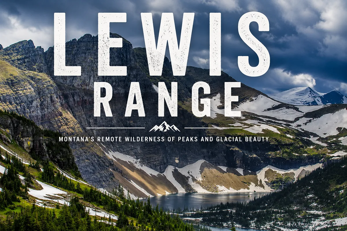
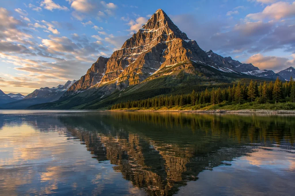
The Lewis Range is the half of Glacier National Park that most people know. Going-to-the-Sun Road climbs its crest. The Highline Trail walks its ridgeline.
Logan Pass sits at its high point. Many Glacier’s iconic photographs — the ones with the turquoise lakes, the wedge-shaped peaks, and the grizzlies on the slopes — are all Lewis Range pictures.
Even if you’ve never heard the name “Lewis Range,” you’ve seen it. Mount Cleveland (10,479 ft) is the high point, Chief Mountain is the geological masterpiece, and the entire range sits on top of one of the most extraordinary thrust faults in the world.
The Lewis Range is the eastern spine of Glacier National Park, running about 100 miles from the Marias Pass area north into Alberta, Canada. Mount Cleveland (10,479 ft) is the high point and the highest peak in the Northern Rockies south of Canada. The range was built by the Lewis Overthrust — a slab of 1.4-billion-year-old rock that slid 50+ miles east over much younger rock 60–100 million years ago. Chief Mountain is the most famous remnant of that overthrust — a sacred peak to the Blackfeet Nation. The range contains the iconic Going-to-the-Sun Road, Many Glacier, Two Medicine, and most of Glacier National Park’s named peaks. The range is part of Waterton-Glacier International Peace Park — the first in the world. Best window: late June through mid-September.
Liked this article?
Add Roaming Montana as a preferred source so you see more of our articles and guides on Google.
Why the Lewis Range Is Different
Most Montana mountain ranges are dominated by one feature — a high peak, a major canyon system, a wilderness area. The Lewis Range is dominated by the geological event that built it: the Lewis Overthrust.
Roughly 60 to 100 million years ago, during the Laramide Orogeny, an enormous slab of Precambrian rock — 3 miles thick, 50 miles wide, and 160 miles long — slid eastward over much younger Cretaceous-period rocks.
The slab pushed up and over the existing landscape like an enormous sheet of plywood sliding across a desk.
When it stopped moving and erosion stripped away the surrounding country, what remained were the mountains we now call the Lewis Range.
The result is one of the strangest things in North American geology: in Glacier National Park, you can look at rock layers that are arranged upside-down by time — billion-year-old rock sitting on top of hundred-million-year-old rock.
You can see the Lewis Overthrust in many places, but the textbook example is Chief Mountain — a free-standing isolated peak (geologists call it a klippe) where erosion has removed all the rock around the overthrust slab, leaving just one dramatic remnant.
Chief Mountain is one of the most famous geological klippes in the world, and the Blackfeet Nation considers it sacred.
For broader context, see my full Montana mountain ranges guide and the parallel Livingston Range guide.
Where the Lewis Range Is
The Lewis Range forms the eastern spine of Glacier National Park, running roughly 100 miles from the Marias Pass area in the south, north through Glacier and across the Canadian border into Waterton Lakes National Park in Alberta. The Continental Divide runs along the crest of the range for much of its length.
The range is bordered:
- West: Parallel to the Livingston Range, separated by the Continental Divide and various drainages
- East: The Great Plains of the Rocky Mountain Front — a sharp, dramatic transition from prairie to peaks
- North: Crosses into Alberta and continues into Waterton Lakes National Park
- South: Terminates around Marias Pass and the southern boundary of Glacier National Park
The range crosses Glacier, Flathead, Pondera, Lewis and Clark, and Teton counties in Montana, plus southern Alberta. The eastern side of the range abuts the Blackfeet Indian Reservation, with the eastern boundary of Glacier National Park essentially being the boundary of the reservation.
Major access points:
- Going-to-the-Sun Road — the central artery, crossing the range over Logan Pass (6,646 ft)
- Many Glacier — east-side access to the most iconic Glacier landscapes
- Two Medicine — southeastern access via the Blackfeet Reservation
- St. Mary — east entrance and visitor center
- Chief Mountain Highway — northeastern access, leading to Waterton Lakes NP
- Marias Pass (US-2) — southern access, the only east-west route across the range that’s open year-round
The Lewis Overthrust: How the Range Was Made
The Lewis Overthrust is one of the most famous structural geology features in the world. Geology students from across North America come to Glacier specifically to see it.
Here’s the basic story. During the Late Cretaceous and early Paleocene (roughly 60 to 100 million years ago), the western edge of North America was being compressed eastward by the subducting Pacific plate.
This compression created the Rocky Mountains — but in the Lewis Range area, the compression took an unusual form.
Instead of folding the rock layers vertically (which is what created most other Rockies), the compression caused a low-angle thrust fault: an enormous slab of Belt Supergroup rock (deposited 1.4 to 1.6 billion years ago when this region was a shallow inland sea) slid eastward along a nearly horizontal fault plane.
The Belt Supergroup slab moved more than 50 miles east, riding over the much younger Cretaceous-period sedimentary rocks that lay beneath. When the slab finally stopped moving and erosion went to work, the landscape we see today emerged.
The most striking feature of the Lewis Overthrust visible from the road is the distinctive layered cliff bands you see all over Glacier — the rust-and-cream-and-green sedimentary layers stacked horizontally on top of one another.
Those are all Belt Supergroup rocks that slid over the top of much younger rock 60+ million years ago.
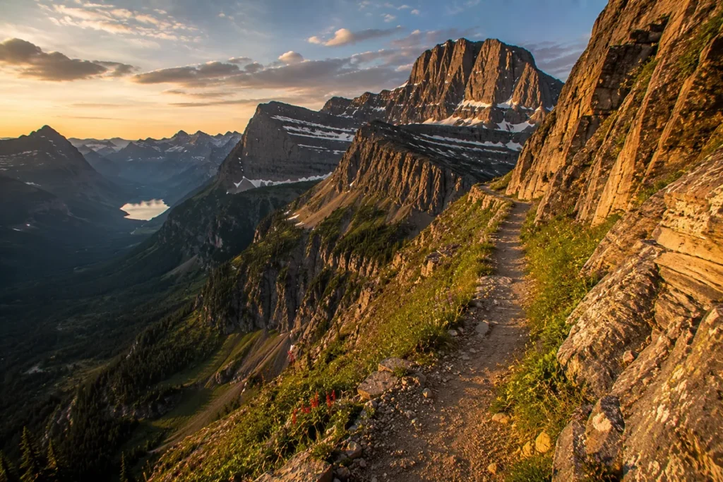
The famous Garden Wall along the Highline Trail, the Many Glacier peaks, Logan Pass — all of them are sitting on top of the Lewis Overthrust.
Mount Cleveland: The High Point
Mount Cleveland, at 10,479 feet (NAVD 88), is the highest peak in:
- The Lewis Range
- Glacier National Park
- The U.S. Northern Rockies (south of the Canadian border)
The peak sits in the far northern part of the park, about 3 miles southeast of Waterton Lake and 5 miles south of the U.S.-Canada border. The first recorded ascent was in 1920 by Frank B. Wynn.
The mountain is named for Grover Cleveland, the 22nd and 24th U.S. President. The east side of what is now Glacier National Park was purchased from the Blackfoot Confederacy in 1895 during Cleveland’s second term — a complicated and contested transaction that has shaped tribal relations with the park ever since.
The Blackfeet Nation’s relationship with the eastern half of Glacier National Park is one of the most fraught Indigenous-park histories in the National Park system; the tribe was paid roughly $1.5 million in 1895 for lands they had previously been told they could continue to use, with later disputes about hunting and access continuing into the 21st century.
Climbing Mount Cleveland is a serious undertaking. The standard West Face route is 8 miles and 6,100 vertical feet of gain from Goat Haunt (the boat-accessed ranger station at the south end of Waterton Lake), with only 2 of those 8 miles on actual trail.
The Sierra Club’s 1925 Bulletin described it this way after the first recorded ascent: “that the ascent of Mt. Cleveland involves all the difficulties and hardships of the Red Kaweah, Mt. Whitney, and Mt. Shasta combined.”
The mountain is not technical (Class 3/4 on the easiest routes) but it’s long, exposed, route-finding-intensive, and weather-prone. Most parties take 2–3 days. The mountain is one of the most committing peak ascents in the contiguous United States.
A grim note: in December 1969, five young climbers from the Bigfork-Kalispell area attempted a winter ascent of the north face of Mount Cleveland.
An avalanche swept all five to their deaths. Their bodies were not recovered until the following summer.
The incident remains one of the most consequential mountaineering tragedies in American history, and it’s part of why winter ascents of Mount Cleveland are now extraordinarily rare.
Chief Mountain: The Klippe
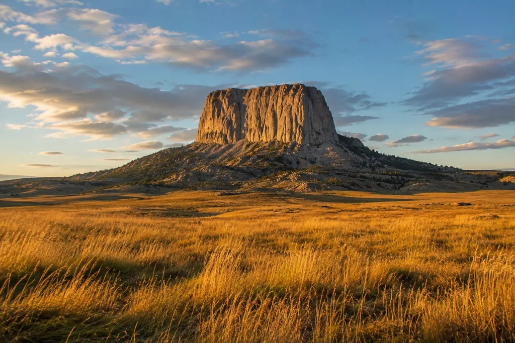
Chief Mountain (Nínaiistáko) stands at the northeast corner of Glacier National Park, on the border with the Blackfeet Indian Reservation. At 9,080 feet, it isn’t even close to the highest peak in the park. But it’s possibly the most distinctive.
Why It Looks Like It Does
Chief Mountain is what geologists call a klippe — a remnant block of an overthrust sheet that’s been isolated by erosion. The mountain itself is composed of 1.4-billion-year-old Precambrian limestone sitting on top of much younger Cretaceous rock.
All the rock that originally surrounded Chief Mountain on the overthrust slab has eroded away, leaving just this one dramatic block standing alone, rising abruptly about 5,000 feet above the Great Plains to the east.
The mountain is visible for nearly 100 miles in every direction — particularly striking from southern Alberta, where businesses in towns like Lethbridge use “Chief Mountain” in their names because the peak is the dominant landmark on the southern horizon.
Sacred Mountain
To the Blackfeet Nation — and to the Kootenai, Salish, and Cree peoples — Chief Mountain is sacred. The Blackfoot name Nínaiistáko (sometimes written Ninaistako) translates roughly as “Chief” or “Sacred Mountain.”
For centuries, the mountain has been a vision-quest site, a place of ceremonial gatherings, and (in some traditions) a place of ancestral emergence. Tribal members continue to visit the mountain to leave offerings and conduct ceremonies.
Climbing Chief Mountain is technically possible — there’s a non-technical route from the west — but it’s discouraged out of respect for tribal religious practices, and access from the easier eastern approach requires a permit from the Blackfeet Nation (when they choose to issue them).
The most appropriate way to experience Chief Mountain is from the Chief Mountain Highway (Montana Highway 17), which approaches it from the south and continues into Canada. The east-face view from this road is one of the great mountain visuals in the American West.
For broader Montana Indigenous history context, see Montana history.
The Other Major Peaks
The Lewis Range contains 496 named mountains per geographic surveys, with several other peaks of significance:
Mount Stimson (10,142 ft)
The second-tallest peak in Glacier National Park and one of the most remote major summits in the park. The standard approach takes 15+ miles of hiking just to reach the base. Few climbers attempt it.
Mount Jackson (10,052 ft)
Often photographed from the Going-to-the-Sun Road, visible across St. Mary Lake. The Jackson Glacier below the peak is one of the park’s still-active glaciers, viewable from the Jackson Glacier Overlook on Going-to-the-Sun Road.
Mount Siyeh (10,019 ft)
The fifth tallest peak in Glacier and the sixth peak in the park to exceed 10,000 feet. Named after Sai-yeh, a Blackfeet warrior whose name means “Crazy Dog” or “Mad Wolf.”
First ascended by Norman Clyde in 1924. Mount Siyeh’s north face is one of the highest unbroken cliff faces in the contiguous United States, dropping nearly 4,000 feet in a single drop.
Going-to-the-Sun Mountain (9,642 ft)
The peak that gives the famous road its name. The Blackfeet have multiple stories about the mountain, often involving a deity named Sour Spirit who came from the sun to teach the Blackfeet how to hunt.
Clements Mountain, Mount Oberlin, Mount Reynolds
The three iconic peaks visible from Logan Pass — among the most photographed mountains in the park.
Mount Wilbur, Mount Grinnell, Mount Gould
The dramatic peaks of the Many Glacier valley — the “wedge-shaped” peaks that appear in nearly every Glacier National Park photograph.
Going-to-the-Sun Road
The Lewis Range is the range that Going-to-the-Sun Road crosses. Built between 1921 and 1932, the 50-mile road climbs from Lake McDonald on the west side to St. Mary Lake on the east side, crossing Logan Pass at 6,646 feet — the high point and a National Historic Landmark.
The road is open seasonally — typically late June through mid-October, depending on snowpack. Plowing the road each spring is itself a multi-week operation that has its own following.
For full coverage, see our dedicated Going-to-the-Sun Road guide.
The Best Hikes in the Lewis Range
The Lewis Range hosts most of Glacier National Park’s most famous trails. For a comprehensive guide, see our best hikes in Glacier National Park post. Here are the essential Lewis Range hikes:
Highline Trail
The classic Glacier ridge walk. From Logan Pass north along the Garden Wall (the spine of the Lewis Range), 11.6 miles to The Loop. Nearly all of it is above timberline with views down into the McDonald Creek valley. Among the most-walked trails in the park.
Iceberg Lake
A 9.7-mile round-trip from the Many Glacier hotel area to a lake that holds icebergs into late summer. One of the most popular Glacier hikes.
Grinnell Glacier
A 7.6-mile (without boat) or 10.6-mile (with boat shortcut) hike from Many Glacier to a viewpoint above one of Glacier’s still-active glaciers. The glacier has shrunk dramatically — what you see is a fraction of what was there in 1900.
Avalanche Lake
A 5.9-mile out-and-back hike from the Going-to-the-Sun Road to a stunning lake at the foot of the Sperry Glacier basin. Family-friendly, on the west side of the Lewis Range crest.
Two Medicine Pass / Dawson Pass Loop
A serious 17-mile loop from Two Medicine Lake over two passes with panoramic views. Less crowded than the Going-to-the-Sun Road hikes.
Pitamakan Pass
A spectacular but demanding 18-mile loop from Two Medicine through pristine alpine country.
Hidden Lake
A 5.4-mile round-trip from Logan Pass to one of the most photographed views in the park. Watch for bighorn sheep and mountain goats along the trail.
Waterton-Glacier International Peace Park
The Lewis Range crosses the Canadian border, and the range is the centerpiece of the Waterton-Glacier International Peace Park — a joint Montana–Alberta protected area with three remarkable designations:
- First International Peace Park in the world (1932) — the U.S. Congress and Canadian Parliament jointly created the park to commemorate friendly relations between the two countries. No other peace park existed at the time.
- UNESCO Biosphere Reserve (1976) — recognition of the ecological significance.
- UNESCO World Heritage Site (1995) — recognition of the outstanding universal value.
- First transboundary International Dark Sky Park (provisional Gold Tier, 2017) — recognition that the park has some of the darkest skies in North America. The dark sky designation is a meaningful one — Glacier’s night sky, viewed from Logan Pass or from Polebridge on the west side, is genuinely extraordinary.
See our Montana night sky guide for more on dark sky travel in the state.
Wildlife in the Lewis Range
The Lewis Range is part of the Crown of the Continent Ecosystem — one of the most intact temperate-zone ecosystems in the world.
Grizzly bears — the Northern Continental Divide Ecosystem (Glacier + the Bob Marshall complex) supports roughly 1,100 grizzlies, the largest population south of Canada. The Lewis Range is dense grizzly habitat. Bear spray is required equipment. See our Montana bear guide.
Black bears — abundant throughout.
Gray wolves — recolonized from Canada in the 1980s; established populations now use the entire range.
Mountain lions, wolverines, lynx — all present, rarely seen.
Mountain goats — common at higher elevations; reliable sightings at Logan Pass.
Bighorn sheep — also common; reliably seen on the Going-to-the-Sun Road area.
Moose, elk, mule deer, white-tailed deer — all abundant.
Bald eagles, peregrine falcons, harlequin ducks, common loons — bird life is exceptional.
Where to Base Yourself
East Side: St. Mary, East Glacier Park Village, Babb, Browning
Best for: Many Glacier access, the east side of Going-to-the-Sun Road, Chief Mountain Highway, Two Medicine, and Blackfeet Reservation cultural visits.
- St. Mary sits at the east entrance to Going-to-the-Sun Road. Limited lodging, but well-positioned.
- East Glacier Park Village is the main southeastern community, with the historic Glacier Park Lodge.
- Babb is the tiny community north of St. Mary on the way to Many Glacier and Chief Mountain.
- Browning is the largest Blackfeet Reservation community, about 30 minutes east. Population about 1,000.
West Side: West Glacier, Columbia Falls, Whitefish
Best for: West side of Going-to-the-Sun Road, Lake McDonald, Avalanche Lake, and combined trips into the Livingston Range via the North Fork.
- West Glacier is the western park entrance gateway. Smaller services, but right at the park boundary.
- Columbia Falls is about 25 minutes from West Glacier. Real services, lodging, restaurants.
- Whitefish is about 35 minutes from West Glacier. Larger tourist town with the Whitefish Mountain Resort.
Kalispell
The full-service regional city, about 1 hour from West Glacier. Glacier Park International Airport (FCA) is between Kalispell and Whitefish.
Best Time to Visit
The Lewis Range has a defined hiking season due to high elevation, deep snow, and Going-to-the-Sun Road access.
Late June through early July — Going-to-the-Sun Road typically opens in late June. Lower trails are accessible; high passes still have snow.
Mid-July through mid-September — prime hiking window. Wildflowers peak in late July. The Highline Trail is fully open. The peak summer crowd is heaviest in late July and August.
Mid-September through early October — fall larch color on the west side (the Lewis Range has fewer larch than the Livingston Range, but they’re still present), thinner crowds, but increased weather risk. Going-to-the-Sun Road typically closes in mid-October.
Winter the high country is the domain of cross-country skiers and snowshoers. Going-to-the-Sun Road is closed; access is limited to the West Glacier and St. Mary entrance areas.
For seasonal context, see Montana in July, Montana in August, and Montana in October.
Personal Tips: What I Wish I Knew About the Lewis Range
Going-to-the-Sun Road requires a vehicle reservation in summer. Glacier has implemented timed-entry vehicle reservations during peak season (typically late May through mid-September). Plan ahead — these sell out months in advance. Check NPS.gov for current requirements.
Many Glacier is the iconic Lewis Range experience. If you have to pick one valley, pick Many Glacier. The mix of accessible trails, dramatic peaks, alpine lakes, and reliable wildlife is unmatched anywhere else in the park.
Chief Mountain is best seen from the south on the Chief Mountain Highway. Drive Montana Highway 17 from Babb toward the Canadian border. The east face of Chief Mountain reveals itself slowly as you climb. One of the great mountain views in North America.
The Blackfeet Reservation deserves respect. The east side of Glacier National Park sits adjacent to the Blackfeet Indian Reservation, and the history between the park and the Tribe is genuinely complicated. Visit thoughtfully. Buy from Blackfeet-owned businesses when you can. The Museum of the Plains Indian in Browning is excellent.
Bear spray is required. Carry on the hip, not in the pack. The Lewis Range has one of the densest grizzly populations in the Lower 48.
The dark sky designation is real. Bring a camera, find a clear night, and go to Logan Pass or St. Mary Lake after dark. The Milky Way over the peaks is among the great experiences available in any U.S. national park.
Don’t try to “see Glacier” in a single day. The park’s east and west sides are entirely different experiences, separated by 50 miles of mountain road. Plan three to four days minimum for a proper Lewis Range visit.
Cell service is limited. Lake McDonald Lodge, the Apgar Visitor Center, and St. Mary Visitor Center have some service. The vast majority of the park has none.
Mount Cleveland is for serious mountaineers only. Don’t underestimate it. The peak has killed multiple parties, and even non-fatal accidents are common.
Practical Info Box
| Item | Detail |
|---|---|
| Highest peak | Mount Cleveland, 10,479 ft (highest in Glacier NP and U.S. Northern Rockies south of Canada) |
| Range length | ~100 miles N–S |
| Named peaks | 496 |
| National Park | Glacier National Park (Lewis Range is the eastern spine) |
| International extension | Waterton Lakes National Park, Alberta, Canada |
| Joint designation | Waterton-Glacier International Peace Park (first in world, 1932) |
| UNESCO Biosphere Reserve | 1976 |
| UNESCO World Heritage Site | 1995 |
| First transboundary Dark Sky Park | 2017 |
| Geology | Belt Supergroup (1.4–1.6 billion years), emplaced by Lewis Overthrust |
| Major scenic drive | Going-to-the-Sun Road (Logan Pass, 6,646 ft) |
| Best basecamp east | St. Mary or East Glacier Park Village |
| Best basecamp west | West Glacier, Columbia Falls, or Whitefish |
| Bear spray | Required gear |
| Vehicle reservation required (summer) | Yes — check NPS.gov |
| Nearest airport | Glacier Park International (FCA, ~45 min from West Glacier) |
Final Thoughts
The Lewis Range is what most people mean when they say “Glacier National Park.” It’s where the road climbs, where the iconic photographs are taken, and where the geological story of the park is most legible.
It’s also the half of the park that millions of travelers visit each summer — meaning a Lewis Range trip is a balance between unforgettable scenery and meaningful effort to avoid the worst of the crowds.
If you’ve never been: do Going-to-the-Sun Road in one day, then plan a second day in Many Glacier. Watch sunset from St. Mary Lake. Drive Chief Mountain Highway.
If you’ve been once: hike the Highline Trail, then plan a second visit to the Livingston Range to see the quieter half of the park.
If you’re committed: backpack into the Lewis Range high country for multiple days — Stoney Indian Pass, Boulder Pass, or the Goat Haunt area.
For broader context on how the Lewis Range fits alongside Montana’s other ranges, see the full Montana mountain ranges guide.
Frequently Asked Questions
Where is the Lewis Range?
The Lewis Range forms the eastern spine of Glacier National Park, running about 100 miles from Marias Pass north into Alberta, Canada, where it continues as part of Waterton Lakes National Park. The Continental Divide runs along the crest.
What’s the highest peak in the Lewis Range?
Mount Cleveland at 10,479 feet — also the highest peak in Glacier National Park and the highest peak in the U.S. Northern Rockies south of the Canadian border.
What is Chief Mountain?
Chief Mountain (Blackfoot name Nínaiistáko) is a 9,080-foot isolated klippe — a remnant block of the Lewis Overthrust — at the northeast corner of Glacier National Park. It rises about 5,000 feet abruptly from the Great Plains. The mountain is sacred to the Blackfeet, Kootenai, Salish, and Cree peoples.
What is the Lewis Overthrust?
A massive low-angle thrust fault, active 60–100 million years ago, that pushed a slab of 1.4-billion-year-old Precambrian rock approximately 50 miles eastward over much younger Cretaceous rock. The Lewis Range and Glacier National Park sit on top of this overthrust.
Is the Lewis Range the same as Glacier National Park?
No. Glacier National Park contains two parallel mountain ranges — the Lewis Range (eastern spine) and the Livingston Range (western spine), separated by the Continental Divide and various drainages.
Can you drive across the Lewis Range?
Yes, on the famous Going-to-the-Sun Road, which crosses Logan Pass at 6,646 feet. The road is typically open late June through mid-October.
Where is Going-to-the-Sun Road?
Going-to-the-Sun Road runs 50 miles across the Lewis Range in Glacier National Park, connecting Lake McDonald on the west to St. Mary on the east via Logan Pass.
Who is Mount Cleveland named for?
Grover Cleveland, the 22nd and 24th U.S. President. The east side of what is now Glacier National Park was purchased from the Blackfoot Confederacy during Cleveland’s second term in 1895.
Are there grizzly bears in the Lewis Range?
Yes. The Lewis Range is part of the Northern Continental Divide Ecosystem, which supports the largest grizzly population in the contiguous United States (~1,100 bears). Bear spray is required equipment.
Where do you stay near the Lewis Range?
East side: St. Mary, East Glacier Park Village, Babb. West side: West Glacier, Columbia Falls, or Whitefish. Larger regional base: Kalispell. The two sides of the park have different access points and require driving over Going-to-the-Sun Road (~2 hours each direction).