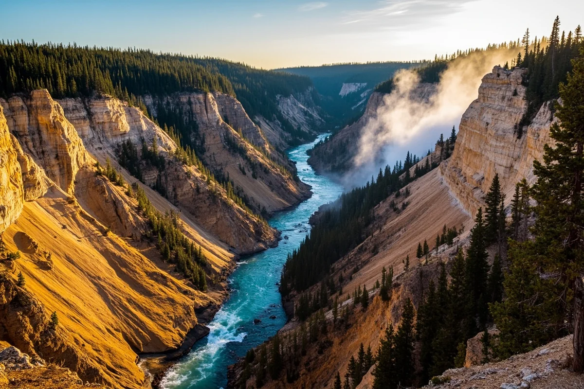
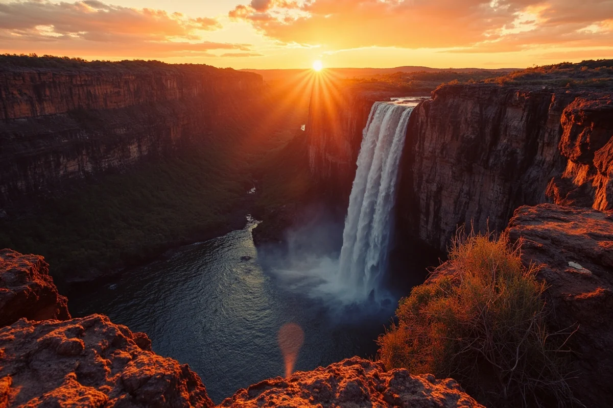
The mist hit my face before I even saw the water. Standing at the Uncle Tom’s Trail overlook last August, I watched 308 feet of Yellowstone River plunge into a golden canyon so vivid it almost looked artificial—except no artist could capture this.
Lower Falls isn’t just one of the most spectacular Montana waterfalls you’ll encounter; it’s the kind of natural wonder that makes you understand why early explorers thought they’d discovered the gates of another world.
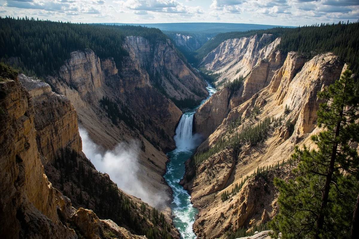
- Lower Falls drops 308 feet—nearly twice the height of Niagara Falls
- Best viewpoints: Artist Point (easy), Uncle Tom’s Trail (328 steel steps), Brink of Lower Falls (steep but rewarding)
- Peak season: June through September, with July offering maximum water volume
- Arrive before 8 AM or after 5 PM to avoid crowds and catch golden hour light
- Located in Yellowstone’s Canyon Village area, technically in the Montana/Wyoming border region
- Free with Yellowstone National Park entrance fee ($35/vehicle for 7 days)
What Makes Lower Falls So Extraordinary
I’ve chased waterfalls across Montana for years, from the hidden gem of Grotto Falls to the thundering power of Kootenai Falls in the northwest corner. But Lower Falls exists in a category entirely its own.
At 308 feet, it’s roughly twice the height of Niagara Falls. But the statistics don’t capture what you feel standing at any of its viewpoints—that visceral combination of raw power, impossibly colored rock, and the knowledge that this same scene has been reshaping the Earth for over 10,000 years.
The Yellowstone River gathers momentum from Yellowstone Lake and Upper Falls before reaching this cliff edge. During my visit in late July, park rangers estimated the flow rate at approximately 63,500 gallons per second. That’s enough water to fill an Olympic swimming pool every ten seconds.
Understanding the Geography
Let me clear up a common confusion I encountered while planning my trip. Lower Falls sits within Yellowstone National Park’s Canyon Village area. While the park straddles both Wyoming and Montana, Lower Falls technically falls on the Wyoming side of the border.
However, it’s a critical destination for anyone exploring Montana’s waterfall circuit. The falls sit just 25 miles south of the Montana border, and most travelers visiting from Bozeman, Livingston, or Gardiner will naturally include it in their Montana waterfall itinerary.
The Grand Canyon of the Yellowstone stretches 20 miles long, up to 1,200 feet deep, and as wide as 4,000 feet in places. Lower Falls marks the dramatic beginning of this canyon, where the river makes its spectacular plunge.
The Viewpoints: A Complete Breakdown
During my visit, I made it my mission to hit every major viewpoint. Here’s what I discovered about each one, including details the park brochures don’t always mention.
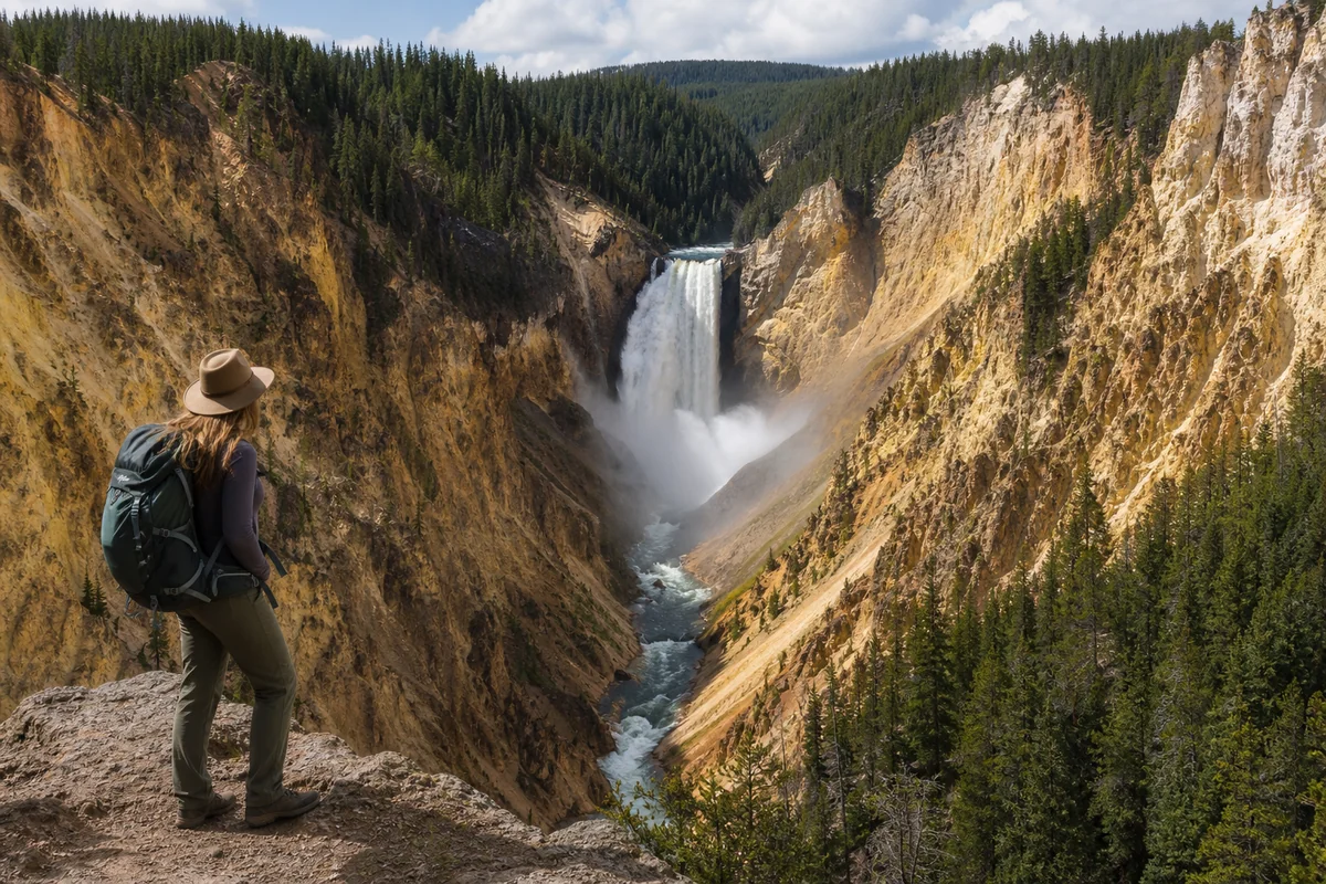
Artist Point
This is the most famous vantage point, and for good reason. The panorama from Artist Point has inspired painters and photographers since Thomas Moran captured it in 1871, helping convince Congress to establish Yellowstone as America’s first national park.
The walk from the parking lot takes about five minutes on a paved, wheelchair-accessible path. When I arrived at 7:15 AM on a Thursday morning, I had the viewpoint nearly to myself for about twenty minutes before the crowds started building.
From Artist Point, you see the falls framed by the canyon’s famous yellow, orange, and pink walls. The morning light hits the eastern canyon wall perfectly, illuminating those sulfur-stained rhyolite rocks that give Yellowstone its name.
My honest assessment: This viewpoint delivers the classic postcard shot, but you’re viewing the falls from a distance. It’s perfect for understanding the scale of the canyon but less impressive for feeling the waterfall’s power.
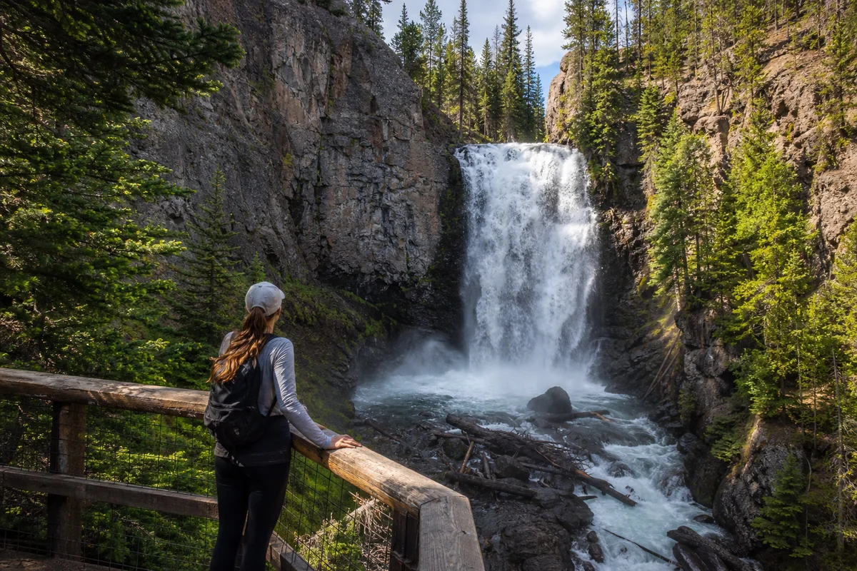
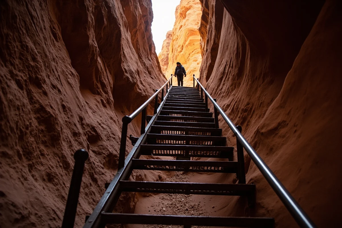
Uncle Tom’s Trail
If you only have time for one viewpoint and you’re reasonably fit, make it this one. Uncle Tom’s Trail descends 328 steel steps bolted into the canyon wall, dropping you 500 feet closer to the falls.
I won’t sugarcoat it—the climb back up is brutal. I stopped three times on my ascent, and I hike regularly. My heart rate was still elevated fifteen minutes after reaching the top.
But standing on that platform at the bottom, with the falls roaring so loud you can’t hear the person next to you, feeling the mist soak through your jacket—that’s an experience worth every gasping breath on the return climb.
The trail gets its name from “Uncle Tom” Richardson, who built the original trail in the 1890s using rope ladders and wooden steps. He charged tourists $1 per descent. The modern steel structure is considerably safer, though still not for those with a fear of heights.
Brink of Lower Falls
This trail provides the most dramatic perspective: standing directly above the waterfall, watching the river rush past your feet before plunging into the void.
The hike descends about 600 feet over 0.5 miles, with the final stretch featuring steep switchbacks. I found it more strenuous than Uncle Tom’s Trail overall because of the distance, though the steps themselves are less extreme.
At the brink, a sturdy viewing platform lets you peer over the edge. The sound is deafening—a constant low rumble you feel in your chest more than hear with your ears. During my visit, I watched a raven ride the thermal updrafts rising from the canyon below, seemingly unbothered by the chaos of water behind it.
Safety note: The mist here can make the viewing platform slippery. I saw several people in flip-flops struggling. Wear proper hiking shoes with good traction.
Lookout Point and Red Rock Point
These two viewpoints work as a pair. Lookout Point sits right off the main parking area with a quick walk to an elevated platform. Red Rock Point requires descending an additional 0.25-mile trail with steep sections.
I appreciated Red Rock Point for its middle-distance view—closer than Artist Point but more panoramic than Uncle Tom’s Trail. It also sees fewer visitors because of the extra effort required.
North Rim Viewpoints
The North Rim Drive offers several pullouts with canyon views, though Lower Falls appears more distant from this side. I found the North Rim better suited for appreciating the canyon’s full scope rather than focusing specifically on the waterfall.
The Inspiration Point turnoff leads to three different viewing platforms. During my visit, the highest one was closed for maintenance, but the lower platforms still delivered impressive vistas.
Practical Trail Information
| Viewpoint | Distance | Difficulty | Time Needed |
|---|---|---|---|
| Artist Point | 0.1 miles | Easy (paved) | 15-30 minutes |
| Uncle Tom’s Trail | 0.5 miles round trip | Strenuous (328 steps) | 45-90 minutes |
| Brink of Lower Falls | 1.0 miles round trip | Strenuous (600 ft elevation) | 1-1.5 hours |
| Lookout Point | 0.1 miles | Easy | 15-20 minutes |
| Red Rock Point | 0.5 miles round trip | Moderate | 30-45 minutes |
Best Times to Visit
Seasonal Considerations
I’ve now seen Lower Falls in both summer and early fall, and each season offers distinct advantages.
June-July: Maximum water flow from snowmelt creates the most dramatic display. The falls roar with almost intimidating force. However, this coincides with peak tourist season. I counted over 200 people at Artist Point during a mid-morning visit in July.
August-September: Water levels decrease but remain impressive. Crowds thin noticeably after Labor Day. My late August visit offered a nice balance—still powerful falls with manageable visitor numbers.
October: The canyon walls contrast beautifully with any remaining golden foliage. Water flow is at its lowest, which some argue makes the canyon colors more visible. Roads typically remain open until early November, weather depending.
Winter: The falls transform into a partially frozen spectacle. Access is limited—the South Rim Drive closes to vehicles, requiring snowshoe or ski access. I haven’t attempted a winter visit yet, but photographs from that season reveal an entirely different character.
Time of Day
Photography enthusiasts have long debated the best light for Lower Falls. After experimenting on multiple visits, here’s my take:
Sunrise to 9 AM: Golden light hits the canyon walls from the east. Artist Point looks spectacular. The falls themselves may be slightly shadowed, but the warm canyon colors compensate. Crowds are minimal.
9 AM to 4 PM: Harsh overhead light washes out the canyon colors somewhat. However, the falls themselves are fully illuminated. This timing works best for capturing the water’s texture and movement. Crowds peak around 11 AM.
4 PM to Sunset: Warm light returns, now hitting the western canyon wall. The Brink of Lower Falls viewpoint catches beautiful golden hour light. I’ve found this timing offers the best combination of light quality and manageable crowds.
Photography Tips from the Field
I brought both a full-frame DSLR and my smartphone during my last visit, testing techniques at each viewpoint. Here’s what I learned.
Gear Recommendations
A polarizing filter proved essential at Artist Point, cutting through the mist and enhancing the canyon colors. Without it, my test shots looked hazy and flat.
At Uncle Tom’s Trail and the Brink, I switched to a faster shutter speed to freeze the water motion. The volume here is so massive that silky long-exposure effects looked unnatural to me. I preferred capturing individual water droplets and spray.
A wide-angle lens (24mm or wider) helps at most viewpoints, but I was surprised how often I reached for my 70-200mm telephoto at Artist Point. Isolating sections of the canyon wall or compressing the falls against the background added variety to my shots.
Dealing with Mist
At Uncle Tom’s Trail and the Brink, lens mist is inevitable. I kept a microfiber cloth in my pocket and wiped the lens between every few shots. Some photographers use rain sleeves, which I’ll try on my next visit.
My smartphone actually performed better in misty conditions than expected—the waterproof coating on modern phones handles light mist well.
Working Around Crowds
At Artist Point, I arrived early enough to stake out my preferred position at the railing. But by 9 AM, people constantly walked into my frame.
My solution: switching to a longer exposure (1/15th second or slower) caused moving people to blur slightly, making them less distracting. Alternatively, I took multiple shots and later combined them in editing software, using areas where people weren’t present in each frame.

Combining Lower Falls with Other Montana Waterfalls
If you’re building a Montana waterfall road trip, Lower Falls fits naturally into several routes.
The Yellowstone Circuit
Within Yellowstone, Upper Falls (109 feet) sits just upstream and deserves a quick stop. Tower Fall, about 18 miles north on the road toward Mammoth, adds another impressive 132-foot cascade.
If you’re entering through Gardiner from Bozeman, consider a detour to Ousel Falls near Big Sky on your approach. It’s a quick, family-friendly hike offering a nice warm-up.
The Southwest Montana Loop
Travelers based in Bozeman can easily combine a Yellowstone day trip with other regional waterfalls. Palisade Falls near Hyalite Reservoir makes an excellent morning excursion before heading into the park.
The Western Montana Connection
For those on longer trips, Montana’s western reaches offer entirely different waterfall experiences. Holland Lake Falls in the Swan Valley and Morrell Falls near Seeley Lake both provide outstanding backcountry hiking with spectacular payoffs.
Wildlife Encounters
The Canyon Village area supports significant wildlife populations, and I’ve had memorable encounters during my Lower Falls visits.
Bison frequent the meadows near Canyon Junction. During one morning drive, I waited fifteen minutes while a herd crossed the road. Never approach bison—they can run 35 mph and have injured more visitors than any other animal in the park.
I spotted a black bear near the Cascade Lake trailhead, about two miles from the canyon rim. The bear was focused on grazing and moved away from the trail, but the sighting reminded me to carry bear spray on all hikes.
Ospreys nest along the canyon rim, and I watched one dive into the river below the falls—a remarkable display of hunting precision given the turbulent water conditions.
Accessibility and Visitor Services
Accessibility Options
Artist Point offers the only fully accessible viewpoint, with a paved path from the parking lot. The viewing platform accommodates wheelchairs and has a lowered railing section for unobstructed views.
Lookout Point on the North Rim also provides a relatively accessible option, though the final steps to the platform may challenge some visitors.
All other viewpoints require navigating stairs or steep terrain. During my visit, I spoke with a park ranger who mentioned that the park service has studied additional accessibility improvements but faces challenges given the canyon’s geological constraints.
Facilities
Restrooms are available at the Artist Point parking area and near the Brink of Lower Falls trailhead. Both were clean and well-maintained during my visits.
Canyon Village, about a five-minute drive from the main viewpoints, offers:
- General store with snacks, drinks, and basic hiking supplies
- Full-service restaurant and cafeteria
- Visitor education center with canyon exhibits
- Gas station
- Camping and lodging options
I grabbed coffee and a breakfast burrito from the cafeteria before my early morning hike—the food quality exceeded my expectations for a national park concessionaire.
Planning Your Visit: Practical Details
Getting There
From Bozeman: Take US-191 south through Big Sky and into the park via the West Entrance. Continue to Madison Junction, then east to Canyon Village. Total drive time: approximately 2 hours, depending on traffic and wildlife stops.
From Livingston: Take US-89 south through Gardiner and the North Entrance. Follow the Grand Loop Road south through Tower Junction to Canyon Village. Total drive time: approximately 1 hour 45 minutes.
From Cody, Wyoming: Enter through the East Entrance on US-20 and drive west to Canyon Village. This route passes Yellowstone Lake and offers stunning scenery. Total drive time: approximately 1 hour 30 minutes.
Entrance Fees and Passes
Yellowstone National Park charges $35 per private vehicle for a 7-day pass. If you’re planning multiple park visits, the $80 America the Beautiful annual pass provides excellent value.
During summer, the entrance gates can have wait times exceeding 30 minutes during peak hours. I’ve found arriving before 8 AM or after 4 PM minimizes this delay.
When Viewpoints Are Open
The South Rim Road (providing access to Artist Point and Uncle Tom’s Trail) typically opens in late April or early May, weather permitting. The road closes for the winter season in early November.
The Brink of Lower Falls Trail may open later than the road due to snow and ice conditions on the steep descent. Check the park’s current conditions page before planning a visit specifically for this viewpoint.
Safety Considerations
Lower Falls viewpoints are generally safe, but the park service reports injuries every year from visitors who ignore posted warnings.
Stay on Designated Trails
The canyon rim is unstable in many areas. The rock is rhyolite—volcanic in origin and prone to crumbling. During my visit, I watched a group of teenagers climb over a barrier for a photo, sending loose rocks cascading into the canyon. Beyond the danger to themselves, they could have injured visitors below.
Watch Your Step
Mist from the falls makes rocks and metal surfaces slippery. On Uncle Tom’s Trail, the steel grating provides good traction when dry but becomes treacherous when wet. I gripped the handrail on my descent even though I felt it was overkill—and I was grateful for that habit when I slipped slightly near the bottom.
Altitude Awareness
Canyon Village sits at approximately 7,900 feet elevation. Visitors from lower elevations may experience mild altitude effects. I felt slightly winded on Uncle Tom’s Trail despite being well-acclimated from previous Montana travels. Drink plenty of water and take breaks as needed.
Weather Changes
Mountain weather shifts rapidly. I started one hike in bright sunshine and encountered hail within 40 minutes. Bring layers and rain gear regardless of the morning forecast.
Where to Stay
Inside the Park
Canyon Lodge and Cabins offers the most convenient base, located within walking distance of Canyon Village facilities and a short drive from all viewpoints. I stayed here during my July visit and appreciated the location despite the relatively basic accommodations. Book months in advance for summer dates.
Camping at Canyon Campground puts you even closer to the action. The campground operates on a reservation system through Recreation.gov, and popular dates fill quickly.
Gateway Communities
For those who prefer lodging outside the park, Gardiner (North Entrance) and West Yellowstone offer numerous options. From Gardiner, you can reach Canyon Village in about 45 minutes via the Grand Loop Road.
I’ve also enjoyed staying in Livingston, about 50 minutes from Gardiner. The town offers excellent restaurants, a charming downtown, and generally lower prices than gateway communities.
Hidden Gems Near Lower Falls
While the famous viewpoints deserve their reputation, I discovered several lesser-known experiences during my visits.
Clear Lake Trail
This 1.5-mile trail departs from the Wapiti Lake Trailhead near the Uncle Tom’s Trail parking area. The path leads to Clear Lake, a small thermal lake that lives up to its name. The trail passes through lodgepole pine forest and offers solitude even during peak season.
Ribbon Lake Loop
For those wanting a longer hike, the 4-mile Ribbon Lake Loop trail connects Artist Point with views of Silver Cord Cascade—one of Yellowstone’s highest waterfalls at over 1,200 feet, though the thin ribbon of water makes it easy to miss.
Cascade Lake
Just west of Canyon Village, Cascade Lake provides a peaceful backcountry experience. The 5-mile round trip hike features wildflower meadows in July and good chances of wildlife sightings. It’s popular enough to feel safe but quiet enough to escape the crowds.
Making the Most of a Single Day
If you’re only visiting Lower Falls for one day—the situation most travelers face—here’s the itinerary I’d recommend based on my experience:
6:30 AM: Arrive at Artist Point parking lot. Walk to the viewpoint and enjoy the quiet. Take your classic photographs while crowds are minimal.
7:30 AM: Drive to the Brink of Lower Falls trailhead. Hike down to the brink. The morning light at this viewpoint is spectacular, and the trails are still relatively empty.
9:30 AM: Return to your vehicle. Drive to Uncle Tom’s Trail. The descent is easier while your legs are fresh, and you’ll beat the midday rush.
11:00 AM: Finish Uncle Tom’s Trail. Drive to Canyon Village for lunch and a break. Visit the education center to learn more about canyon geology.
1:00 PM: Drive to the North Rim. Check out Lookout Point and Inspiration Point for different perspectives.
3:00 PM: If energy remains, take the Clear Lake Trail or Ribbon Lake Loop.
5:30 PM: Return to Artist Point for golden hour photography. The evening crowds are smaller than midday, and the light transforms the canyon.
Beyond Lower Falls: Expanding Your Waterfall Quest
After experiencing Lower Falls, many travelers catch waterfall fever. Montana delivers countless opportunities to continue the chase.
In Glacier National Park, Running Eagle Falls offers a unique geological feature where the falls actually emerge from the face of a cliff during low water periods. Saint Mary Falls and Ptarmigan Falls both provide excellent hiking destinations on the park’s east side.
For those seeking less crowded experiences, Memorial Falls near Great Falls and Skalkaho Falls in the Sapphire Mountains offer rewarding visits without the national park crowds.
Adventurous hikers should consider Mission Falls in the Mission Mountains Wilderness—a challenging trek that rewards effort with a stunning 800-foot cascade.
The Lost Creek Falls area near Anaconda provides another excellent option for those seeking off-the-beaten-path experiences, while Rock Creek Falls offers easy access for families and those with limited hiking experience.
Final Thoughts
Lower Falls represents one of those rare natural phenomena that exceeds even inflated expectations. I’ve visited iconic waterfalls across the American West, from Multnomah to Yosemite, but this one stays with me.
Maybe it’s the canyon’s alien color palette. Maybe it’s the sheer volume of water making that 308-foot leap. Maybe it’s knowing that the same forces creating this spectacle continue reshaping the landscape beneath your feet.
Whatever the reason, Lower Falls earns its place as a must-see destination for anyone exploring Montana and the greater Yellowstone region. Plan for crowds, prepare for physical effort, and leave space in your memory for something extraordinary.
I’ll be back next spring when the snowmelt swells the Yellowstone River to its peak flow. Some places deserve repeat visits, and this is definitely one of them.
Frequently Asked Questions
Where is Lower Falls located in Montana and how do I get there?
Lower Falls is located in Yellowstone National Park’s Grand Canyon area, accessible from the park’s Montana entrances near Gardiner or West Yellowstone. From Gardiner, it’s approximately 35 miles south to Canyon Village, where you’ll find multiple viewpoints including the famous Uncle Tom’s Trail and Artist Point. I recommend entering through the North Entrance for the most scenic drive along the Yellowstone River.
What is the best time of year to visit Lower Falls in Yellowstone?
The best time to visit Lower Falls is late May through early June when snowmelt creates maximum water flow, making the 308-foot waterfall absolutely thunderous. I’ve found that early morning visits in summer (before 9 AM) offer the best lighting for photos and smaller crowds. Fall visits in September provide golden foliage backdrop, though water volume is significantly reduced.
How much does it cost to see Lower Falls and do I need a park pass?
You’ll need a Yellowstone National Park entrance pass to access Lower Falls, which costs $35 per vehicle for a 7-day pass or $80 for an annual America the Beautiful pass. There are no additional fees to view the waterfall or hike the surrounding trails. I always recommend the annual pass if you’re planning to visit multiple national parks during your Montana trip.
What should I bring when hiking to Lower Falls viewpoints?
Bring sturdy hiking shoes with good grip, especially for Uncle Tom’s Trail which has 328 steel stairs that can be slippery when wet. I always pack layers since canyon temperatures can be 10-15 degrees cooler than the plateau, plus sunscreen, water, and a rain jacket for afternoon thunderstorms. A telephoto lens or binoculars will help you spot the rainbow that often forms in the mist.
How difficult is the hike to see Lower Falls and is it family-friendly?
The South Rim Trail to Artist Point is paved, wheelchair-accessible, and perfect for families with young children—it’s only about 0.5 miles round trip. Uncle Tom’s Trail is moderately strenuous due to the steep 500-foot descent and return climb, which I’d recommend only for those comfortable with stairs and elevation (7,700 feet). The North Rim Trail offers easier viewpoints like Brink of the Lower Falls, though the final section involves a steep paved path.
Can you swim at Lower Falls Montana or get close to the waterfall?
Swimming at Lower Falls is strictly prohibited and extremely dangerous due to the powerful current, 308-foot drop, and cold water temperatures. The closest you can safely get is the Brink of the Lower Falls viewpoint, where you’ll feel the mist and hear the roar just above where the water plunges into the canyon. I’ve seen the viewing platforms get wet from spray, so protect your camera gear accordingly.
How long should I spend at Lower Falls and nearby Grand Canyon of the Yellowstone?
Plan at least 2-3 hours to properly explore Lower Falls and the Grand Canyon of the Yellowstone viewpoints on both the North and South Rim drives. If you want to hike Uncle Tom’s Trail and walk to multiple overlooks, I’d budget half a day to fully appreciate this area without rushing. Combining Lower Falls with nearby Upper Falls and the canyon’s colorful walls makes this one of the most rewarding stops in the entire park.
Sources