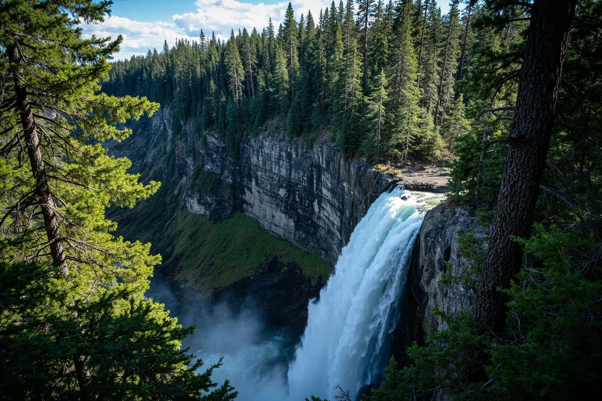
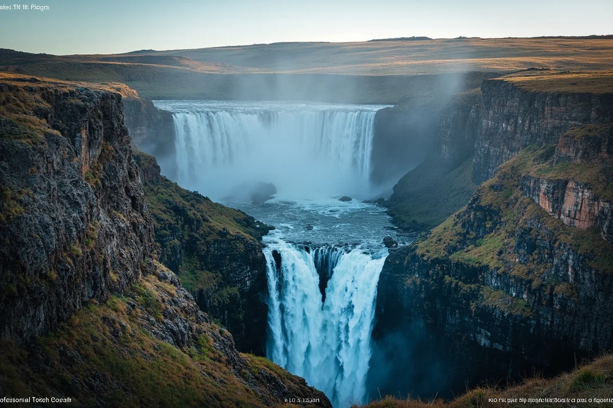
The moment I rounded that final switchback and heard the thunderous roar echoing off granite walls, I knew every grueling mile had been worth it.
Needle Falls isn’t just another waterfall—it’s a backcountry reward that most visitors to Montana will never experience, and standing in its mist last August felt like discovering a secret the mountains had been keeping for millennia.
If you’re exploring Montana waterfalls, this one deserves a spot on your bucket list, even if reaching it requires real effort.
- Needle Falls drops approximately 80 feet in the Absaroka-Beartooth Wilderness near Cooke City
- The hike is roughly 8-10 miles round trip depending on your route, rated moderate to strenuous
- Best visited July through September when trails are snow-free
- No permit required for day hiking, but wilderness regulations apply
- Bring bear spray, plenty of water, and sturdy boots—this isn’t a casual stroll
- Limited cell service means you need a physical map or downloaded GPS tracks
What Makes Needle Falls Special
Unlike more accessible cascades such as Ousel Falls near Big Sky or the roadside Kootenai Falls in northwestern Montana, Needle Falls demands that you earn the view. That barrier to entry is precisely what makes it magical.
When I finally reached the falls during my visit, I had the entire scene to myself for nearly two hours. No crowds jostling for photos, no drone buzzes overhead—just the cascade, the wildflowers, and a curious marmot who seemed more annoyed by my presence than impressed.
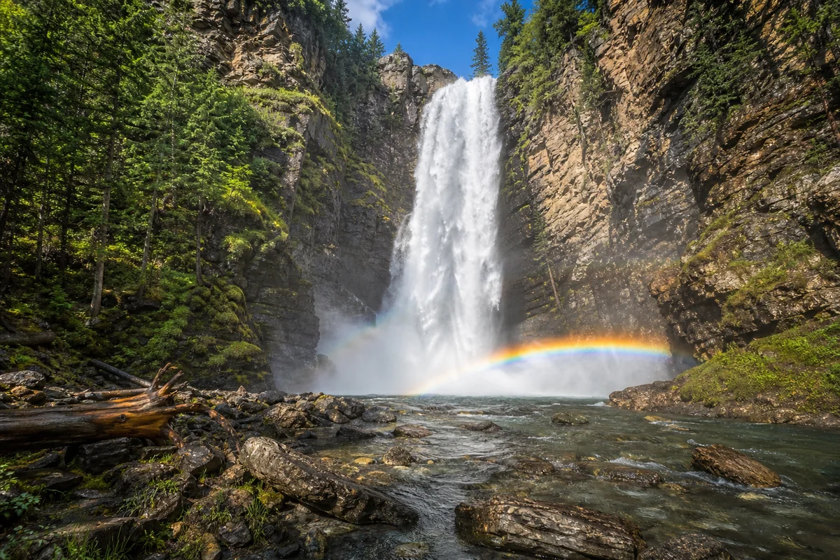
The falls get their name from the needle-like rock spire that stands sentinel beside the main drop. This distinctive geological formation creates a unique framing that photographers dream about, with the water splitting and rejoining as it navigates ancient volcanic rock.
Getting to the Trailhead
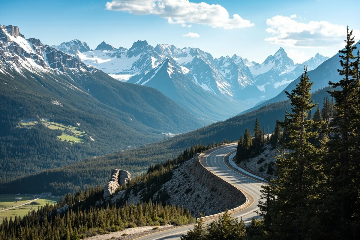
Reaching the starting point for Needle Falls requires navigating some of Montana’s most spectacular—and sometimes challenging—terrain. The primary access point is via the Beartooth Highway (US-212), which itself is worth the journey.
From Cooke City
I started my trip from Cooke City, a tiny mining town turned tourism gateway just northeast of Yellowstone National Park. From Main Street in Cooke City, head east on US-212 toward the Beartooth Pass.
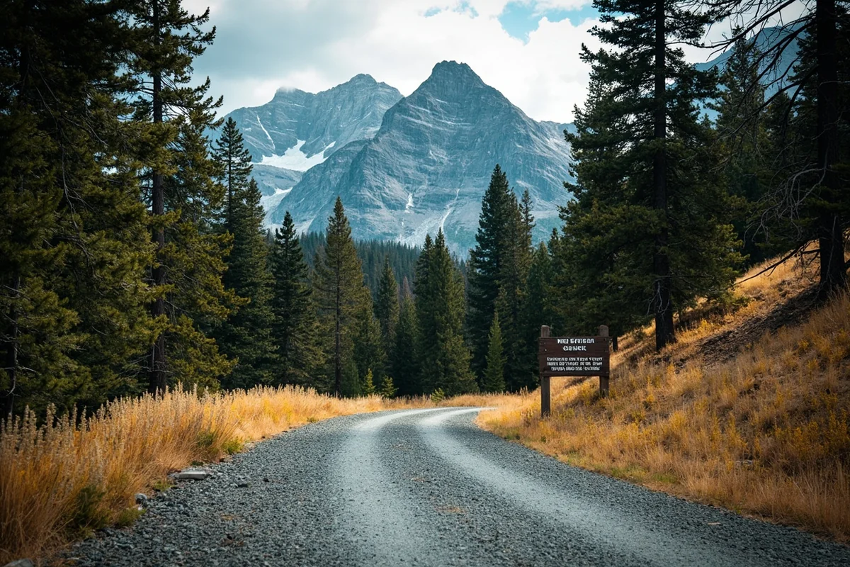
After approximately 3 miles, you’ll pass Colter Pass and begin the winding ascent. Keep your eyes peeled for the Forest Service road turnoff on your right—it’s easy to miss if you’re distracted by the jaw-dropping scenery.
The gravel Forest Service road extends about 4 miles to the actual trailhead parking area. During my August visit, my rental SUV handled it fine, but I wouldn’t attempt this in a low-clearance sedan after rain.
From Red Lodge
If you’re approaching from Red Lodge, you’ll drive the famous Beartooth Highway in its entirety—a 68-mile journey that regularly takes 2-3 hours due to the endless photo opportunities and switchbacks.
The turnoff comes before you reach Cooke City, on your left side as you descend from the pass. I recommend this direction if you want to witness sunrise from the Beartooth Plateau before your hike.
| Starting Point | Distance to Trailhead | Drive Time |
|---|---|---|
| Cooke City | 7 miles | 25-30 minutes |
| Red Lodge | 61 miles | 2-2.5 hours |
| Billings | 127 miles | 3.5-4 hours |
| Gardiner (via Yellowstone) | 85 miles | 2.5-3 hours |
The Trail to Needle Falls: A Detailed Breakdown
The route to Needle Falls isn’t marked with a giant “WATERFALL THIS WAY” sign—and that’s part of the adventure. The total round-trip distance varies between 8 and 10 miles depending on which fork you take at the creek junction.
First Section: Forest Walk (Miles 0-2)
The trail begins innocently enough through a mixed conifer forest of lodgepole pine and Engelmann spruce. During my summer hike, the forest floor was carpeted with wildflowers—lupine, Indian paintbrush, and delicate fairy slippers hiding in the shadows.
This initial section gains only about 400 feet of elevation, lulling you into a false sense of security. I made the mistake of thinking the whole hike would be this gentle.
The path is generally well-maintained here, though downed trees from winter storms can create impromptu obstacles. On my trek, I counted three significant blowdowns that required careful navigation.
Second Section: Creek Canyon (Miles 2-4)
After crossing the first tributary on a log bridge (check its stability before committing your full weight—I learned this the slightly damp way), the trail enters a narrow canyon carved by the creek that feeds Needle Falls.
This is where the real climbing begins. Expect to gain another 1,200 feet over the next two miles, with some sections requiring hand-over-hand scrambling.
I recommend trekking poles for this section. The loose scree and exposed roots turn ankles with alarming efficiency.
Third Section: Alpine Approach (Miles 4-5)
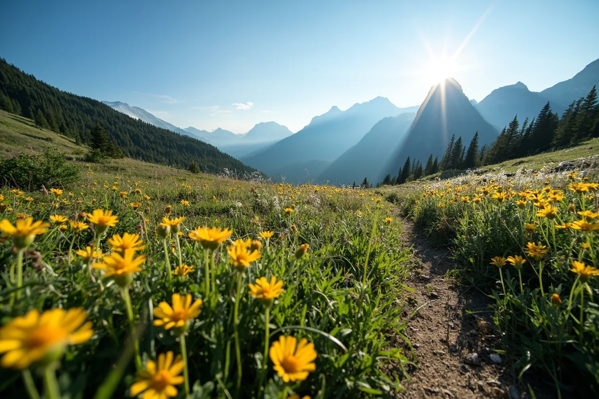
Breaking out of the treeline around mile four was one of those moments that stops you mid-step. The Absaroka-Beartooth Wilderness spreads out in every direction—jagged peaks, remnant snowfields even in August, and wildflower meadows that look almost artificially perfect.
The final mile to Needle Falls traverses this alpine zone. The trail becomes fainter here, marked occasionally by cairns that previous hikers have stacked.
I spent considerable time during my visit just sitting on a boulder at treeline, eating trail mix and wondering why I don’t do this more often. The sheer scale of the landscape makes every Instagram-filtered photo I’ve ever taken look like a participation trophy.
The Final Approach
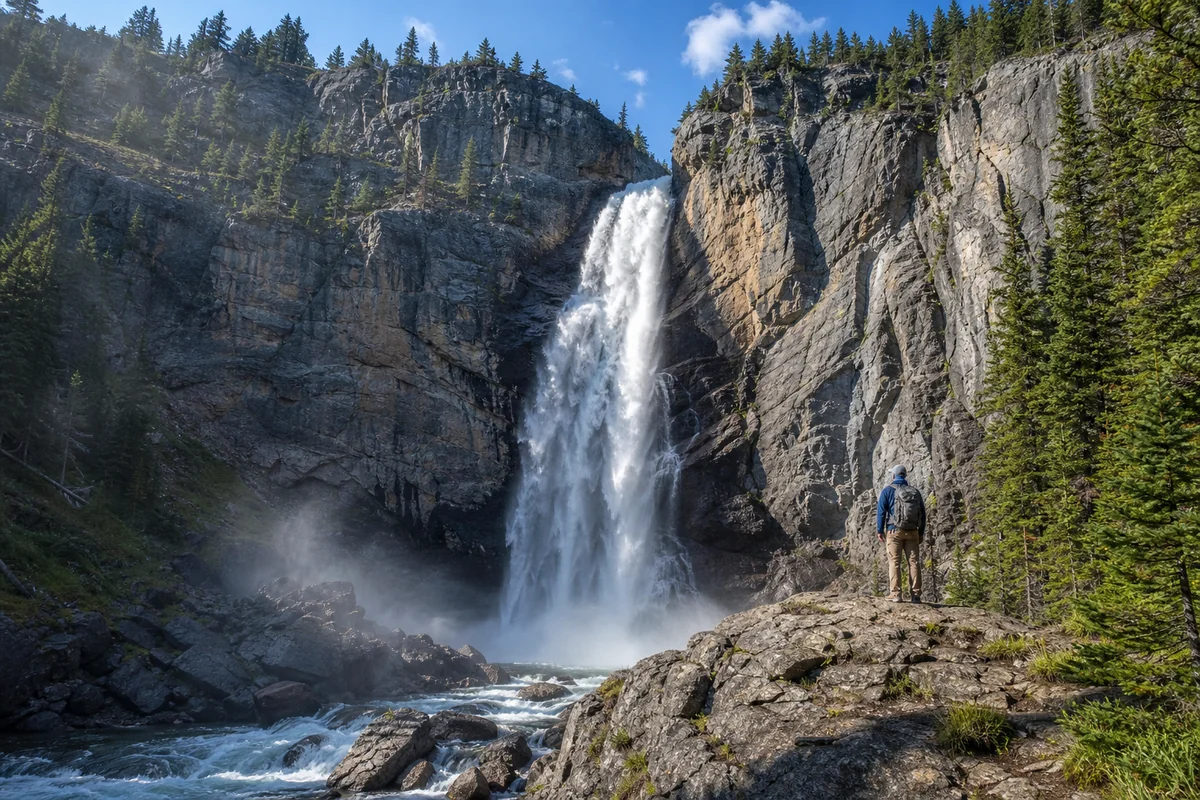
You’ll hear the falls before you see them. The acoustic phenomenon of water pounding rock bounces off the cirque walls, creating a surround-sound experience that builds anticipation with every step.
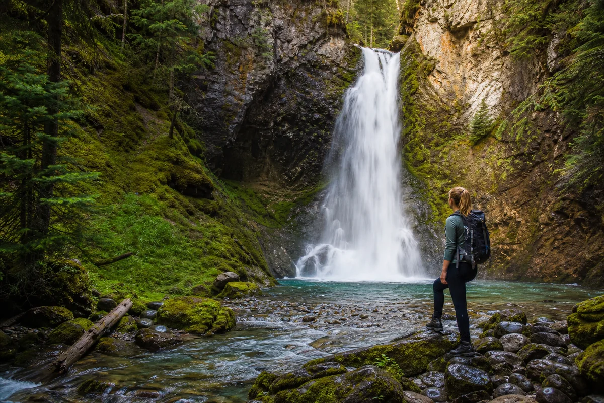
The viewing area is a rocky outcrop about 150 feet from the falls’ base. Getting closer is technically possible but not recommended—the rocks are slick, the current is powerful, and rescue services are many hours away.
When I reached this point last summer, the afternoon sun was hitting the mist at exactly the right angle to create a persistent rainbow arc. I took approximately 47 photos. At least three are usable.
Best Time to Visit Needle Falls
Timing your visit correctly can mean the difference between an unforgettable adventure and a frustrating disappointment. I’ve researched seasonal conditions extensively and can share what I’ve learned.
July: Peak Flow, Lingering Snow
If maximum water volume is your priority, early to mid-July offers the most impressive flows. The snowpack from the surrounding peaks is actively melting, feeding the falls with tremendous force.
However, the trail may still have snow patches above treeline. On my first attempted visit in early July a few years back, I turned around at mile three because of a steep snowfield crossing that felt unsafe without microspikes.
August: The Sweet Spot
My successful August visit hit the perfect balance. The trail was completely snow-free, the falls still had respectable flow, and the wildflowers were at peak bloom.
Afternoon thunderstorms are common in August, so plan for an early start. I was back at the trailhead by 2 PM, and the thunder started rolling around 3:30 PM.
September: Autumn Colors, Lower Flow
The larch trees in the higher elevations turn gold in September, adding another visual dimension to the hike. Water flow diminishes but remains photogenic.
Nights get cold fast—I’ve heard reports of snow as early as mid-September. Check weather forecasts religiously before committing to this late-season window.
October-June: Not Recommended
The Beartooth Highway typically closes in mid-October and doesn’t reopen until late May at the earliest (sometimes mid-June after heavy snow years). Even when the road opens, the trail to Needle Falls remains snow-covered and potentially dangerous.
Unless you’re an experienced backcountry skier with avalanche training, save this adventure for summer.
Essential Gear and Preparation
After my experience and conversations with other hikers I’ve met on Montana trails, I’ve developed strong opinions about what you need for Needle Falls.
The Non-Negotiables
- Bear spray: Grizzlies inhabit this area. I saw fresh scat on my hike. Carry spray accessible on your hip, not buried in your pack.
- Physical map and compass: Your phone will die, lose signal, or both. The Custer Gallatin National Forest map covers this area.
- 3+ liters of water: There are creek crossings where you can filter more, but don’t count on it.
- Layers: I started in shorts and a t-shirt, ended up wearing my puffy jacket at the falls.
- First aid kit: You’re 4-5 hours from the nearest hospital. Basic wound care and blister treatment are essential.
- Headlamp: Even if you plan to be back before dark, plans change.
Highly Recommended
- Trekking poles: The descent absolutely destroyed my knees until I learned to use poles properly.
- Gaiters: The creek crossings and dewy meadow sections soak your socks otherwise.
- Camera with waterproof protection: Mist from the falls reaches the viewing area on windy days.
- Sit pad: Those rocks at the viewpoint get uncomfortable after 15 minutes.
Leave at Home
Cotton clothing, Bluetooth speakers (seriously, don’t be that person), and any expectation of cell service. The wilderness experience here is about disconnection as much as destination.
Wildlife Encounters: What I’ve Seen and What to Expect
The Absaroka-Beartooth Wilderness hosts some of the most diverse megafauna in the lower 48. During my visits to this region, I’ve encountered several species that warrant discussion.
Bears
Both grizzly and black bears roam these mountains. The food sources—whitebark pine nuts, army cutworm moths on the high peaks, and berries—draw them throughout summer.
I haven’t seen a bear on the Needle Falls trail specifically, but I’ve seen them in adjacent drainages. Make noise, carry spray, and know how to use it.
The bear spray instructions are simple: remove safety, aim slightly downward, spray when the bear is 30-60 feet away. Practice drawing it before you need it.
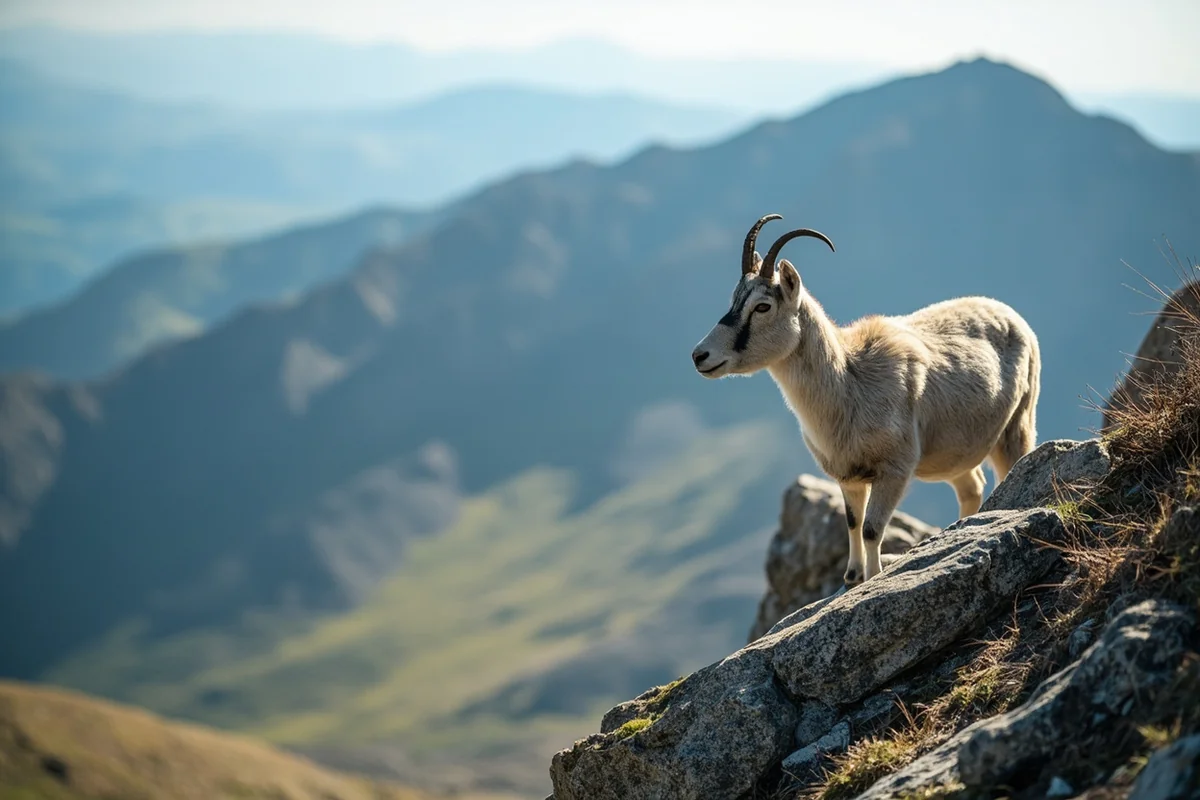
Mountain Goats
The rocky terrain around the falls is prime mountain goat habitat. On my August hike, I watched a nanny with two kids traverse a cliff face that made my palms sweat just observing.
They’re generally not aggressive but will approach for salt—human sweat, urine spots, and food scraps attract them. Follow Leave No Trace principles rigorously.
Smaller Critters
The marmot that kept me company at the falls seemed almost domesticated—a bad sign indicating previous hikers have been feeding wildlife. Don’t contribute to this problem.
I also spotted pikas in the talus fields near treeline, their squeaky alarm calls announcing my presence to anything within earshot.
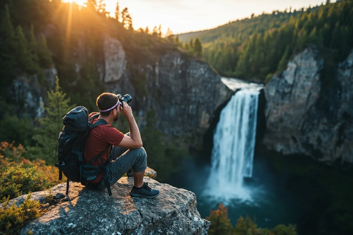
Photography Tips from Someone Who Got It Wrong First
I fancy myself an amateur photographer, which means I’ve made every possible mistake at Montana waterfalls. Let me save you some frustration at Needle Falls.
Timing and Light
The falls face roughly northwest, which means direct sunlight only hits them in late afternoon during summer. This creates harsh shadows and blown-out highlights during the “golden hour” that photographers usually worship.
Instead, aim for overcast conditions or early morning when the entire scene is in soft, diffused light. My best shots came on a partly cloudy day when the sun ducked behind a cloud just as I set up my tripod.
Technical Considerations
Bringing a tripod was worth the weight—those silky long-exposure water shots require stability that handholding simply cannot provide. I use a lightweight carbon fiber model that straps to the outside of my pack.
A polarizing filter helps cut glare off wet rocks and deepen the sky color. I’d rank it as my second most valuable filter after a basic UV protector.
Composition Ideas
The needle-shaped rock formation beside the falls provides an obvious framing element, but don’t let it dominate. I found that stepping left of the main viewpoint revealed an angle where the rock and water create almost parallel vertical lines.
Including a foreground element—wildflowers, fallen logs, or distinctive rocks—adds depth. Some of my favorite shots incorporate the alpine meadow with the falls rising in the background.
Comparing Needle Falls to Other Montana Cascades
Montana has dozens of remarkable waterfalls, and I’ve been gradually checking them off my list. Here’s how Needle Falls stacks up against others I’ve visited.
For accessibility, it can’t compete with roadside options like Memorial Falls near Neihart or the short walk to Palisade Falls outside Bozeman. If you want a waterfall without earning it, look elsewhere.
In terms of raw power during peak flow, Running Eagle Falls in Glacier National Park delivers more consistent thunder. But Running Eagle comes with tour buses and selfie crowds.
For overall backcountry experience, I’d put Needle Falls in the same category as Morrell Falls near Seeley Lake or Holland Lake Falls in the Swan Valley—moderate effort hikes that reward with genuine wilderness immersion.
If you’re seeking an even more remote challenge, Impasse Falls and Ptarmigan Falls push deeper into Glacier’s backcountry. Both require more mileage and potentially overnight trips.
Within Glacier specifically, Grotto Falls, Saint Mary Falls, and Redrock Falls offer stunning cascades with varied difficulty levels. The difference is that Glacier draws millions of visitors annually, while the Absaroka-Beartooth sees a fraction of that traffic.
Practical Planning Details
Let me share the logistical information I wish I’d had before my first attempt at reaching Needle Falls.
Permits and Regulations
Day hiking in the Absaroka-Beartooth Wilderness requires no permit. However, if you’re considering an overnight backpacking trip, you’ll want to check current regulations with the Custer Gallatin National Forest.
The standard wilderness regulations apply: no motorized equipment, no mechanized transport (including mountain bikes), pack out everything you pack in, and camp at least 200 feet from water sources.
Trailhead Facilities
There are none. No bathrooms, no potable water, no ranger station. The parking area is simply a widened section of the Forest Service road with room for perhaps 8-10 vehicles.
Use the restroom in Cooke City before you drive to the trailhead. The Elkhorn Lodge has a public bathroom and serves a solid breakfast if you’re starting early.
Cell Service
Nonexistent. I have Verizon and couldn’t get a single bar anywhere on the trail or at the trailhead. Download your maps offline and tell someone your exact plans before you leave.
Emergency Considerations
The nearest medical facility is the Yellowstone Clinic in Gardiner, about 2 hours from the trailhead. For serious emergencies, the hospital in Livingston is another 50 miles beyond that.
Carry a satellite communicator (Garmin inReach, Zoleo, or similar) if you want emergency communication capability. I invested in one after a close call on a different Montana hike and consider it essential equipment now.
Where to Stay Before or After Your Hike
The Cooke City area offers limited but characterful accommodation options. Planning ahead is essential during summer months.
Cooke City Lodging
I stayed at the Soda Butte Lodge during my successful August trip. The rooms are basic but clean, and the attached restaurant serves the kind of hearty breakfast that fuels a long hike. Expect to pay $120-180 per night in summer.
The Antlers Lodge offers similar accommodations with a slightly more rustic vibe. Both book up weeks in advance during peak season—make reservations early.
Camping Options
Several Forest Service campgrounds dot the Beartooth Highway corridor. Soda Butte Campground near Cooke City and M-K Campground closer to Red Lodge both offer first-come, first-served sites.
I’ve had good luck arriving at Soda Butte by Thursday afternoon for weekend adventures. By Friday evening, it’s typically full.
Red Lodge Alternative
If you can’t find lodging in Cooke City, Red Lodge offers more options ranging from basic motels to vacation rentals. The trade-off is an earlier alarm clock and a longer drive on the Beartooth Highway.
On the plus side, Red Lodge has better restaurant options and actual grocery stores. The Café Regis serves what I consider the best breakfast in Carbon County.
Extending Your Trip: Nearby Adventures
If you’re traveling to the Absaroka-Beartooth region specifically for Needle Falls, you might as well explore more of this incredible landscape.
Other Waterfalls in the Area
The region surrounding Needle Falls offers additional waterfall opportunities for the dedicated chaser. Knowles Falls in nearby Yellowstone and Passage Creek Falls both make excellent additions to a multi-day itinerary.
For something more accessible after your strenuous Needle Falls adventure, consider Sacred Dancing Cascade or McDonald Falls over in Glacier—both offer remarkable scenery with minimal hiking.
Beartooth Highway Exploration
The Beartooth Highway itself deserves a full day of exploration. Charles Kuralt famously called it “the most beautiful drive in America,” and I won’t argue.
Stop at the Beartooth Plateau overlooks, where the alpine tundra ecosystem supports wildflowers found nowhere else in Montana. The Gardner Lake pullout offers access to high-altitude fishing.
Rock climbers gravitate toward the Beartooth spires visible from several highway viewpoints. Even if you don’t climb, watching these athletes navigate vertical granite is free entertainment.
Yellowstone National Park
Cooke City sits at Yellowstone’s northeast entrance, making park exploration a natural extension of your trip. The Lamar Valley wildlife watching, Tower Fall, and Mammoth Hot Springs are all accessible from this starting point.
Just remember that entering Yellowstone requires a park pass ($35 for a seven-day vehicle pass or $80 for an annual pass that covers all national parks).
Honest Assessment: Who Should (and Shouldn’t) Visit Needle Falls
I want to be direct about this, because I’ve seen too many trail rescue stories that started with someone underestimating a hike.
This Hike Is Right for You If:
- You regularly complete 8-10 mile hikes with significant elevation gain
- You’re comfortable with route-finding in areas with faint trails
- You carry and know how to use bear spray
- You can self-rescue from minor injuries like twisted ankles
- You value solitude and wilderness immersion over convenience
This Hike Might Not Be Right for You If:
- You’re new to hiking and haven’t built up to longer distances
- You have mobility limitations that make rough terrain dangerous
- You’re uncomfortable being hours from help if something goes wrong
- You need cell service for safety or anxiety reasons
- You’re traveling with young children or inexperienced hikers
There’s no shame in choosing a more accessible waterfall. Montana has plenty of options like Skalkaho Falls, Hidden Falls, or Lost Creek Falls that deliver beauty without the backcountry commitment.
Similarly, if you want to experience Glacier’s waterfalls with easier access, Oberlin Falls, Piegan Falls, and Silken Skein Falls offer spectacular scenery along maintained trails.
My Final Thoughts on Needle Falls
Standing at the base of Needle Falls last August, mist settling on my face and the roar filling my ears, I understood why some hikers become obsessive about chasing waterfalls. The journey transforms the destination.
Every blister, every moment of “why did I think this was a good idea,” every ounce of water weight in my pack—it all converts into appreciation when you finally arrive.
Needle Falls isn’t the tallest cascade in Montana. It’s not the most powerful. It’s certainly not the easiest to reach. But it exemplifies something I love about this state: the best rewards require effort.
If you’re the kind of traveler who measures experiences in Instagram likes, skip this one. But if you want a story—a real story about challenging yourself, pushing your limits, and discovering something genuinely special—Needle Falls delivers.
I’ll be back next summer, probably with a lighter pack and an earlier start. The mountains have a way of calling you back once you’ve heard their voice.
Just remember: the wilderness doesn’t care about your schedule, your fitness level, or your expectations. It simply exists, wild and indifferent, waiting for those willing to meet it on its own terms.
Needle Falls is one of those places where meeting those terms feels less like a sacrifice and more like a privilege.
Frequently Asked Questions
Where is Needle Falls located in Montana and how do I get there?
Needle Falls is located in the Custer Gallatin National Forest near Big Sky, Montana, approximately 45 miles south of Bozeman. To reach the trailhead, take Highway 191 south through Gallatin Canyon and look for the Porcupine Creek trailhead parking area. The falls require a moderate hike of about 2-3 miles each way through beautiful forested terrain.
What is the best time of year to visit Needle Falls Montana?
The best time to visit Needle Falls is late May through early July when snowmelt creates the most impressive water flow. I recommend visiting on weekday mornings to avoid crowds during peak summer season. The trail may be inaccessible or dangerous during winter and early spring due to heavy snow and ice.
How difficult is the Needle Falls hike and what should I bring?
The Needle Falls trail is rated moderate with some elevation gain and rocky sections that require sturdy hiking boots. I always bring bear spray, plenty of water, snacks, and layers since mountain weather can change quickly. Trekking poles are helpful for creek crossings, and don’t forget your camera for the stunning views.
Is there an entrance fee or permit required to visit Needle Falls?
There is no entrance fee or permit required to hike to Needle Falls since it’s located on National Forest land. However, you may need to display a recreation pass at some trailheads, so I recommend keeping an America the Beautiful pass handy which costs $80 annually. Parking at the trailhead is free but limited, so arrive early during peak season.
Can you swim at Needle Falls Montana?
Swimming at Needle Falls is not recommended due to extremely cold water temperatures, strong currents, and slippery rocks around the base. The water comes directly from snowmelt and remains dangerously cold even in summer months. You can enjoy wading in calmer pools downstream, but always exercise caution around moving water.
Are dogs allowed on the Needle Falls trail in Montana?
Yes, dogs are allowed on the Needle Falls trail but must be kept on a leash no longer than 6 feet per National Forest regulations. I always bring extra water for my dog and watch for wildlife since this is active bear and moose country. The rocky terrain can be tough on paws, so consider dog booties for the hike.
What other waterfalls and attractions are near Needle Falls Montana?
The Gallatin Canyon area offers several other waterfalls worth visiting, including Ousel Falls near Big Sky which is just a 20-minute drive away. You’re also close to Yellowstone National Park’s north entrance, about 50 miles south, making it easy to combine multiple waterfall destinations in one trip. The town of Big Sky offers dining, lodging, and outdoor gear shops if you need supplies.