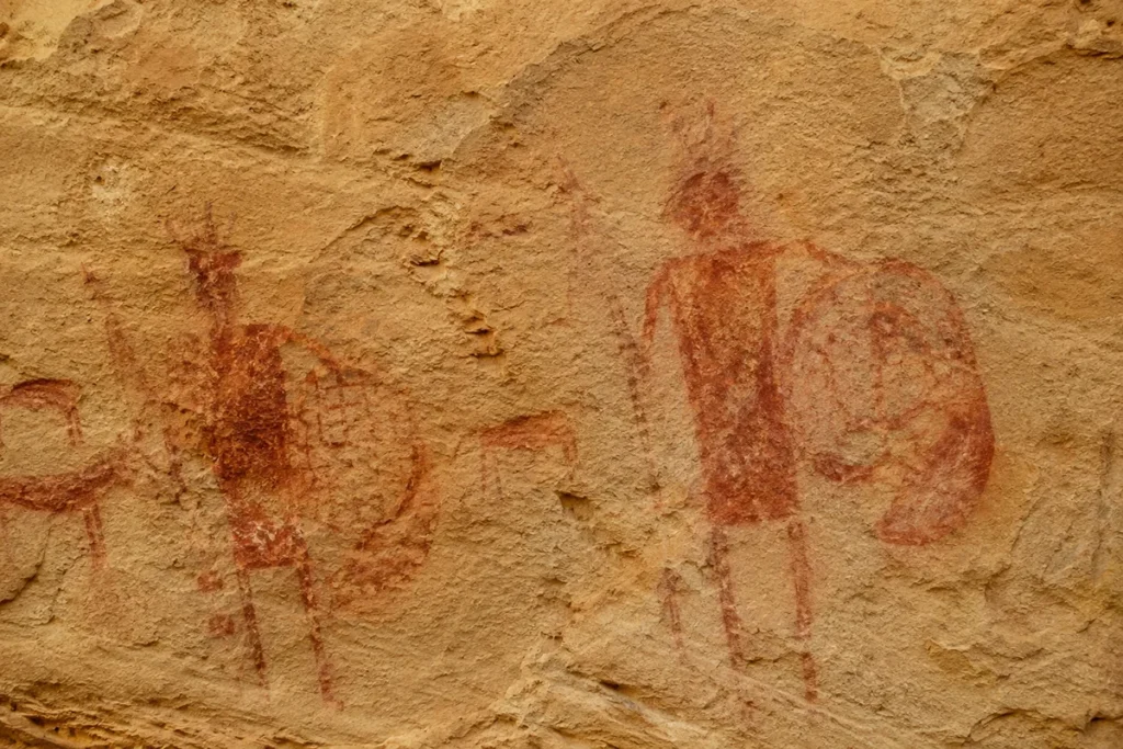
The most striking pictograph at Pictograph Cave isn’t the bison or the warrior figures. It’s a row of seven rifles painted on the sandstone wall — guns acquired by trade or capture, painted by an Indigenous artist sometime after Europeans arrived on the Northern Plains. That image, more than any other in the cave, marks the moment two worlds met.
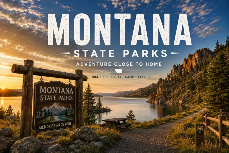
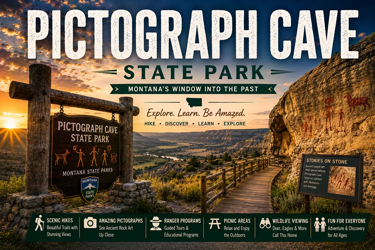
TL;DR: Pictograph Cave State Park sits 7 miles south of Billings and contains one of the most significant prehistoric rock art sites in the Northern Plains — three sandstone caves with over 100 visible pictographs spanning roughly 2,000 years of Indigenous habitation. Designated a National Historic Landmark in 1964. The site was the focus of pioneering archaeological work in 1937–1941 that produced over 30,000 artifacts and helped establish the framework for Northern Plains prehistoric culture studies. Day-use only, free for residents, modest fee for non-residents, year-round access. The 3/4-mile interpretive loop trail is the main visitor experience. Bring binoculars — and visit after rain.
I’m Robert Hayes, and I’ve been visiting Pictograph Cave on and off for two decades. It’s one of those Montana sites that rewards repeat visits — the rock art reveals itself differently in different light, after different weather, with different knowledge in your head. The first visit, you see splashes of color. The fifth visit, you start to see the stories.
This is the deep-dive guide. For the broader Montana state parks landscape, see my Montana state parks pillar guide.
For the federal NPS sites nearby in the Billings area — Little Bighorn Battlefield, Pompeys Pillar — see my Montana national parks pillar guide, which covers all ten NPS-managed sites in Montana and how to combine them with Pictograph Cave for a layered south-central Montana history loop.
Quick Stats
| Stat | Detail |
|---|---|
| Park size | 23 acres |
| Elevation | 3,500 feet |
| Location | 7 miles SE of Billings |
| Number of caves | 3 (Pictograph, Middle, Ghost) |
| Visible pictographs today | ~100 |
| Pictographs originally documented | 150+ |
| Oldest documented art | ~2,100 years old |
| Continuous human use of site | ~10,000+ years |
| Excavation years | 1937–1941 |
| Artifacts recovered | 30,000+ |
| Designated National Historic Landmark | 1964 |
| Loop trail length | ~3/4 mile |
| Annual visitors | ~65,000 |
| Day-use fee [verify 2026] | $8/vehicle (non-resident); free for residents |
| Camping | None (day-use only) |
| Year-round access | Yes; visitor center seasonal |
Pictograph vs. Petroglyph: A Vocabulary Note
Before going further, the terminology matters and confuses a lot of visitors:
- Pictographs are painted images. Pigments are applied to the rock surface.
- Petroglyphs are carved or pecked images. The rock surface itself is modified.
Pictograph Cave contains pictographs — painted figures — not petroglyphs. The pigments used at this site were:
- Red — from hematite (iron oxide), the most common surviving pigment
- Black — from charcoal or ground manganese
- White — from gypsum or chalk-like deposits
The pigments were mixed with binders — animal fat, plant resins, or natural oils — and applied with fingers, brushes made from animal hair, or chewed sticks. Most surviving pigments are red because hematite is the most chemically stable; the white and black figures have largely faded.
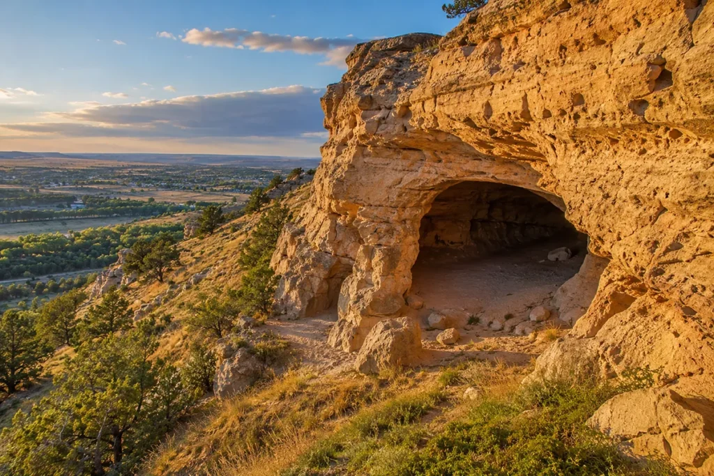
The Three Caves
The site consists of three sandstone caves, all formed by water and wind erosion in the Eagle Sandstone formation, all facing roughly south, all situated along a ridge of cliffs above the Yellowstone Valley:
Pictograph Cave — The largest and the namesake of the park. 160 feet wide and 45 feet deep. This cave has the highest concentration of visible rock art and the most-photographed images. The interpretive trail leads directly to it.
Middle Cave — Smaller than Pictograph Cave but still substantial. Contains additional rock art, though many figures have faded substantially over the past century.
Ghost Cave — The smallest of the three. Contains fewer figures and is named for the indistinct, ghostly quality of the remaining images. Worth visiting both as a stop along the loop and to understand the geological setting.
All three caves are reached from the same 3/4-mile interpretive trail loop that starts at the parking area near the visitor center.
Why This Spot? The 10,000-Year Crossroads
Pictograph Cave wasn’t randomly chosen as a rock-art site. It sits in one of the most logical locations imaginable for prehistoric inhabitants of the Yellowstone Valley.
The geography that mattered:
- South-facing sandstone cliffs trap winter sun and provide warmth
- Natural overhang shelters protected from wind, rain, and snow
- The Yellowstone River valley just to the north supplied water, vegetation, and game
- Elevated cliff position provided a defensive vantage and a way to spot approaching travelers or animal herds
- The valley itself was a major migration corridor for bison and other game
Archaeological evidence indicates continuous human use of the site for at least 10,000 years — meaning people were sheltering here while glaciers still retreated north and while mastodons may still have been roaming the Plains. The painted figures on the cave walls represent only the most recent 2,000-year window of that habitation.
For broader Montana history context, see Montana’s history overview and key historical events in Montana.
Three Eras of Rock Art
The pictographs at the park span approximately 2,000 years and three distinct cultural periods. Knowing the eras helps you read what you’re looking at.
Late Plains Archaic (~2,100+ years ago)
The oldest documented figures. Generally simpler, more abstract compositions — geometric patterns, basic anthropomorphic figures (human shapes), animal silhouettes.
The Pelican Lake culture, named by archaeologist William Mulloy partly based on this site’s excavations, is associated with this period. The hunters who created these images used atlatls (spear-throwers) — bows and arrows weren’t yet in use on the Northern Plains.
Late Prehistoric (~1,500 to 300 years ago)
More elaborate compositions emerge during this period. Bison appear more often. Warrior figures with shields, headdresses, and weapons become common.
The bow and arrow had now replaced the atlatl, and shield-bearing warrior figures reflect the more complex tribal warfare developing across the Plains. This is the most artistically dense layer of figures still visible at the site.
Contact Era (Post-1700)
The newest figures, and the most striking to modern visitors. The famous row of seven rifles painted on the Pictograph Cave wall dates to this era. Other contact-era figures include horseback warriors (horses didn’t reach the Northern Plains until roughly 1700) and trade items like metal blades.
The rifles pictograph is the easiest single figure to see in the entire park. It’s also the most poignant — a snapshot of the moment when European technology was being integrated into Indigenous visual record-keeping. The artist who painted it lived through the most consequential cultural transition in the Northern Plains’ 10,000-year human history.
The 1937–1941 Excavation: How We Know What We Know
Pictograph Cave wasn’t a casual archaeological site. From 1937 to 1941, Dr. William Mulloy of the Montana State University (now University of Montana) led one of the most significant prehistoric excavations ever conducted in Montana.
The work was funded partly by the Works Progress Administration (WPA) during the Depression era and employed local crews working systematically through the cave deposits.
What the excavation found:
- Over 30,000 individual artifacts, including projectile points, bone tools, hide-working implements, and ceramic fragments
- Caribou-horn harpoon points — caribou doesn’t occur in Montana today, suggesting either trade goods from northern populations or a much colder regional climate during early occupation
- 9 grave sites, with associated artifacts indicating burial practices across multiple cultural eras
- Stratigraphic evidence showing continuous occupation across roughly 10,000 years — each cultural layer was preserved above the older ones, like pages in a book
Mulloy’s analysis of the artifacts contributed to defining the Pelican Lake archaeological complex, which describes Late Plains Archaic culture across a wide swath of the Northern Plains. The excavation reports remain foundational reading in Northern Plains archaeology.
The park’s small visitor center exhibits a selection of recovered artifacts and explains the excavation process. It’s worth the 20–30 minutes before walking the trail; the experience at the caves is fundamentally different when you understand what’s been recovered from the cave floor over the years.
Why Many Pictographs Have Faded
The original 1937–1941 documentation identified more than 150 individual figures across the three caves. Today, only about 100 are still clearly visible. The disappearance has accelerated over the past several decades, and unfortunately it’s a one-way process.
Causes of fading:
- Sunlight — Direct UV exposure breaks down pigment chemical bonds over time
- Moisture cycles — Water seeping through the rock dissolves and redeposits minerals over and around the pigment
- Temperature fluctuations — Daily and seasonal expansion/contraction stresses the rock surface
- Salt crystallization — Dissolved minerals crystallize as water evaporates, pushing pigment particles loose
- Modern air quality — Particulates and acidic deposition from regional pollution accelerate degradation
What’s being done:
- Some figures have been documented in detail with photography and tracing for scientific records
- Visitor education emphasizes “look, don’t touch” — even body oils from fingers can accelerate pigment loss
- Climate monitoring inside the caves helps researchers understand conservation challenges
What you see at Pictograph Cave today is not what the artists made. It’s a heavily weathered remnant of a much richer original visual record. Visit while the figures are still visible.
Best Viewing: Time of Day, Time of Year, Time of Weather
This is where most casual visitors get the experience wrong. The pictographs are subtle — faded red, white, and black on weathered tan sandstone. Direct overhead sunlight at midday actually makes them HARDER to see, not easier.
Best viewing conditions:
After rain or snowmelt. Moisture darkens the rock surface and brings out the pigment contrast dramatically. Figures invisible in dry conditions suddenly emerge. If you visit on a day after rain, you’ll see twice as much as the average dry-day visitor.
Early morning or late afternoon. Angled light reveals texture and color contrast that high midday sun washes out. Within an hour or so of sunrise or before sunset is genuinely better.
Overcast days. Counterintuitively, gray skies are often better for pictograph viewing than bright sunny days.
With binoculars. Many figures are above eye level or set back in the cave shadows. A cheap pair of 8×32 binoculars dramatically improves what you can see.
Worst conditions: Bright direct midday sun. You’ll see only the most prominent figures and miss most of the rest.
The Trail and Visitor Experience
The interpretive loop trail is about 3/4 mile total, with elevation gain to access the cave overhangs above the visitor center.
The route:
- Begin at the visitor center parking area
- Walk through the picnic area and past the small interpretive displays
- Climb a series of switchbacks up to the cave-level
- Visit Pictograph Cave first (the main attraction)
- Continue along the cliff base to Middle Cave and Ghost Cave
- Loop back down to the parking area
Trail realities:
- Not wheelchair accessible to the caves (the visitor center and picnic area are accessible)
- Two moderately steep sections require basic fitness
- The path is dirt with some rocky sections
- Allow at least one hour; 90 minutes if you want time at each cave
At the caves:
- Interpretive signage near each cave explains the major visible figures
- A railing keeps visitors back from the cave walls — DO NOT touch the rock
- Photography is allowed; flash is not (it can damage the pigments)
The visitor center is small but substantive — a recreated dig site, artifacts from the 1937–41 excavation, interpretive panels on the Indigenous cultures who used the site, and clean restrooms. Open seasonally [verify 2026 hours with Montana FWP].
Pair Pictograph Cave with Other Billings-Area History
Pictograph Cave is the deepest-time human history site in the Billings area, but it’s not the only one. A two-day south-central Montana history trip can stack four major sites:
The Billings Indigenous History Loop
Day 1: Pictograph Cave State Park in the morning. After lunch, drive 30 minutes east of Billings to Pompeys Pillar National Monument — where William Clark carved his name on July 25, 1806, on his return down the Yellowstone. The two sites in succession give you 2,000-year-old Indigenous art and 220-year-old Euro-American signature on the same itinerary. Overnight in Billings.
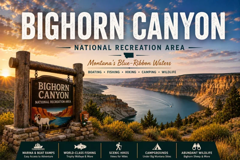
Day 2: Drive 1 hour east to Little Bighorn Battlefield National Monument near Hardin. Spend the morning with the ranger talks. Drive south to Bighorn Canyon National Recreation Area for the afternoon. Return to Billings.
This is the single most concentrated Indigenous-and-frontier history experience available in Montana.
The Chief Plenty Coups Extension
For travelers willing to extend a third day: Chief Plenty Coups State Park is about 35 miles south of Billings in Pryor.
It preserves the home of the famous Crow chief who navigated his tribe through the transition from buffalo-hunting nation to reservation life. The visitor center tells one of the most important Indigenous biographies of the 20th-century West.
The South-Central Montana Long Loop
Add Makoshika State Park (Glendive, far east) and the territorial-era ghost town Bannack State Park (Dillon, southwest) for the most complete history loop in Montana. Both are in this cluster.
Personal Tips: What I Wish I’d Known on My First Visit
Visit after rain whenever possible. I cannot stress this enough. The difference in visibility is dramatic.
Bring binoculars. Even cheap ones. Most figures are at viewing distance where eyes alone aren’t enough.
Stop at the visitor center first. The interpretive context completely changes how you see the figures.
Read the rifles pictograph slowly. It’s the easiest figure to see and the most narratively powerful. Spend a few minutes thinking about who painted it and when.
Take the loop in order. The trail is designed to walk Pictograph → Middle → Ghost. Reversing the order misses some interpretive context.
Don’t touch the rock. Body oils accelerate pigment loss. This is the single most important visitor behavior.
Allow at least an hour. Most visitors rush through in 20 minutes and miss most of the experience.
Combine with a Billings restaurant or brewery. Billings has a serious food and beer scene now. Pictograph Cave in the morning followed by lunch downtown is an easy half-day.
Cell service is fine because you’re essentially on the edge of Billings. This is one of the few Montana state parks where you don’t need to download offline maps.
Photography tips: Polarizing filter to reduce sandstone glare. No flash. Tripod helpful for low-light cave-interior shots. Phone cameras work fine for the obvious figures; longer-lens cameras help capture the more faded ones.
No pets on the cave trail [verify current rules]. Sources conflict on this; check at the visitor center.
Pair with Other State Park Children
For the broader cluster, consider:
- Best for history depth: Pictograph Cave + Bannack State Park (territorial ghost town) — these two sites span Montana from prehistoric to 1860s gold rush
- Best for the Billings area: Pictograph Cave + Bighorn Canyon NRA — both within 90 minutes of Billings; ancient art plus dramatic geology
- Best for “everything Indigenous” Pictograph Cave + Little Bighorn Battlefield + Bighorn Canyon NRA — three sites covering Native American history from 2,000 BCE to 1876 CE
- Best for road-trip variety: Pictograph Cave + Makoshika State Park (Glendive badlands) — the layered Eastern Montana experience
Practical Info Box
| Topic | Quick Answer |
|---|---|
| Day-use fee | $8/vehicle (non-resident); free for residents [verify 2026] |
| Visitor center hours | Seasonal — typically open Apr–Oct [verify 2026] |
| Year-round access | Yes (visitor center seasonal; trail always open) |
| Time needed | 1 hour minimum; 90 minutes recommended |
| Trail length | ~3/4 mile loop |
| Accessibility | Visitor center accessible; cave trail is NOT |
| Camping | None (day-use only) |
| Closest town | Billings (7 miles NW) |
| Closest airport | Billings Logan (BIL) — see Montana airports |
| Driving distance from Billings downtown | 15 minutes |
| Best viewing conditions | After rain or snowmelt; early/late day light; overcast skies |
| Must-bring | Binoculars, water, sunscreen |
| Don’t bring | Flash photography, touching hands |
| Pair with NPS | Little Bighorn Battlefield, Pompeys Pillar |
| Pair with state park child | Bighorn Canyon, Makoshika, Bannack |
Conclusion: A Window Into 10,000 Years
Pictograph Cave is one of those Montana sites that travelers consistently undervalue — it’s small, the art is faded, the visit is short, and there’s no dramatic landscape framing the experience. But the depth of what you’re looking at is genuinely staggering.
Continuous human habitation for 10,000 years. Painted images dating back 2,000 years. The single rifles pictograph documenting the moment two civilizations met. Thirty thousand artifacts pulled from the cave floor.
My recommendation: don’t treat Pictograph Cave as a 20-minute drive-by. Allow a real morning or afternoon. Read the visitor center first. Bring binoculars. Visit after rain if possible. Pair it with another south-central Montana history site for context.
This is one of the most important prehistoric sites in the American West, and it’s sitting 7 miles outside Billings, free of charge for most visitors. Treat it accordingly.
This is the deep-dive. For broader context:
- Montana state parks pillar guide — all 55+ state parks and how to choose
- Montana national parks pillar guide — federal counterpart including Little Bighorn
- Bighorn Canyon NRA — natural pairing for a south-central Montana history loop
- Montana history overview — the broader context
- Things to do in Montana and Montana bucket list — broader trip planning
Drop questions about the cave art, the excavation, or the broader Indigenous history in the comments — I’ll answer from experience.
FAQs About Pictograph Cave State Park
What is Pictograph Cave State Park famous for?
Pictograph Cave State Park is famous for its ancient rock paintings, known as pictographs, created by Indigenous peoples thousands of years ago. The park is one of Montana’s most important archaeological and cultural heritage sites.
Where is Pictograph Cave State Park located?
Pictograph Cave State Park is located just southeast of Billings, Montana. Its convenient location makes it a popular day-trip destination for visitors exploring the Billings area.
How old are the pictographs at Pictograph Cave State Park?
Many of the pictographs are believed to be hundreds to thousands of years old. Archaeological evidence suggests that people used the cave area for shelter and cultural activities for more than 2,000 years.
What are pictographs?
Pictographs are images painted onto rock surfaces using natural pigments. They often depict animals, hunting scenes, symbols, and other cultural or spiritual elements important to the people who created them.
Can you see the pictographs today?
Yes. Visitors can view the pictographs from designated trails and observation areas. The images have faded over time, but many can still be seen while exploring the park.
Is Pictograph Cave State Park worth visiting?
Absolutely. The park offers a unique opportunity to see ancient rock art, learn about Indigenous history, explore archaeological sites, and enjoy scenic walks close to Billings.
How much does it cost to visit Pictograph Cave State Park?
Montana residents generally receive park access through the state parks fee included with vehicle registration. Non-residents may pay a daily entrance fee or purchase an annual Montana State Parks Pass.
Are there hiking trails at Pictograph Cave State Park?
Yes. The park features easy interpretive trails that connect Pictograph Cave, Middle Cave, and Ghost Cave while providing educational information about the area’s history, geology, and archaeology.
How long does it take to visit Pictograph Cave State Park?
Most visitors spend one to two hours exploring the caves, walking the interpretive trails, and viewing exhibits at the visitor center.
Can you enter the caves?
Access policies may vary, but visitors generally view the caves from designated areas to help protect the fragile archaeological resources and rock art within the site.
What animals can you see at Pictograph Cave State Park?
Wildlife commonly seen in the park includes mule deer, rabbits, hawks, songbirds, and various small mammals that inhabit the surrounding grasslands and rock formations.
Is Pictograph Cave State Park family-friendly?
Yes. The park’s short trails, educational exhibits, and fascinating history make it an excellent destination for families, school groups, and visitors of all ages.
What is the significance of Pictograph Cave State Park?
The park preserves one of Montana’s most important archaeological sites, providing valuable insights into the lives, culture, and artistic traditions of Indigenous peoples who lived in the region long before European settlement.
What is the best time to visit Pictograph Cave State Park?
Spring, summer, and fall are the most popular times to visit, offering comfortable weather for walking the trails and exploring the outdoor exhibits.
Why is Pictograph Cave State Park important to Montana history?
The park contains evidence of thousands of years of human activity and preserves rare Indigenous rock art, making it one of Montana’s most significant cultural and historical landmarks.
Written by Robert Hayes, who has visited Pictograph Cave in all four seasons and still sees figures he hadn’t noticed before.