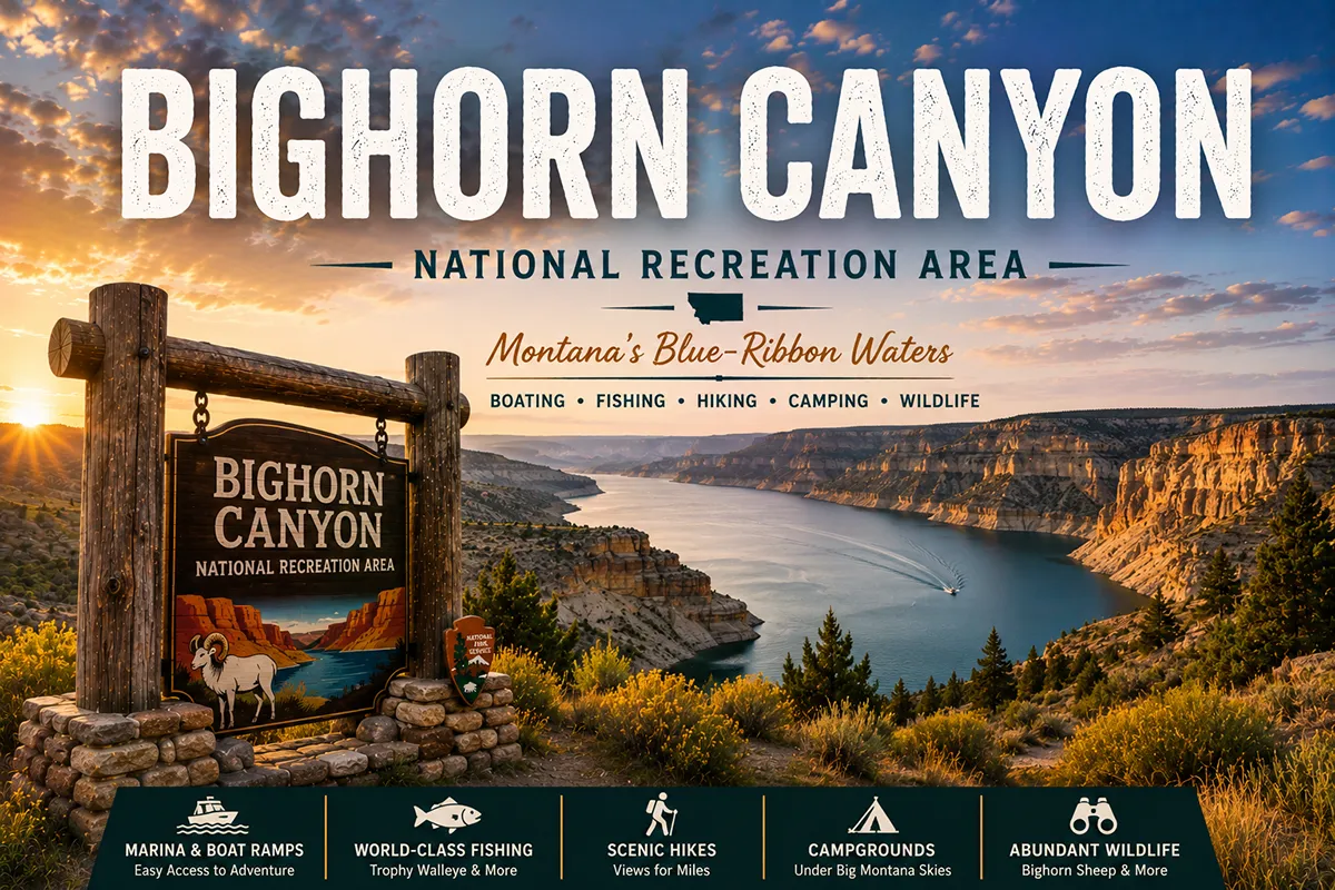
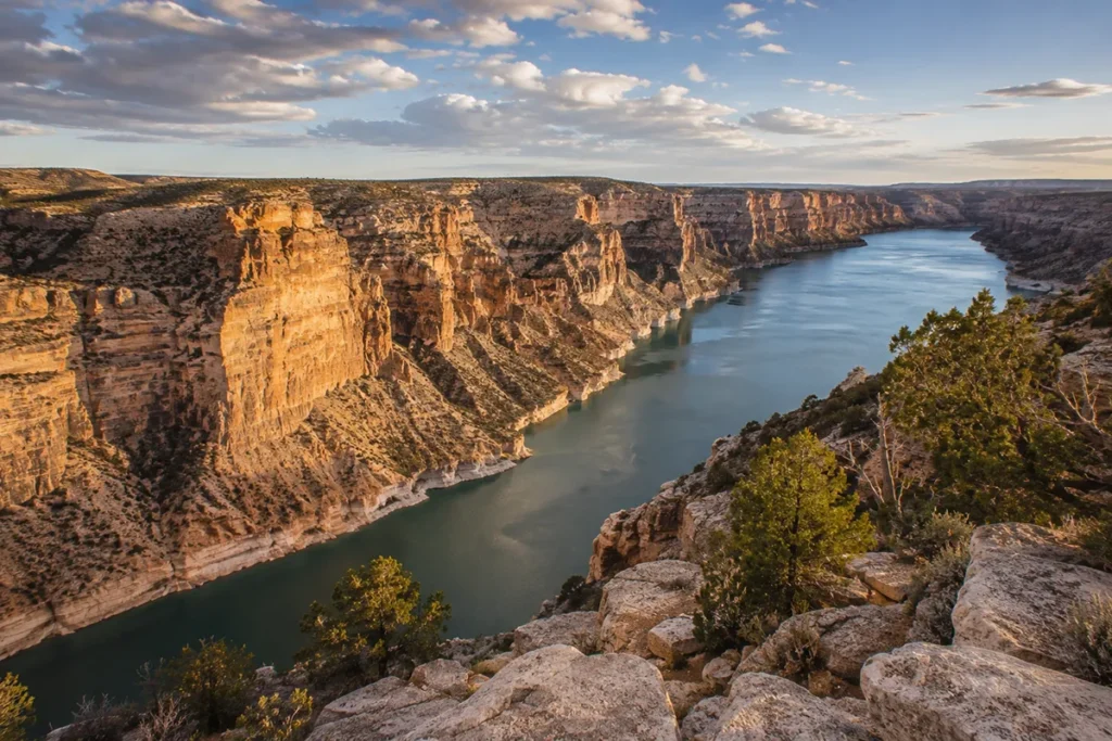
You can stand at Devil’s Canyon Overlook in the South District, look down 1,500 feet to the turquoise water of Bighorn Lake, and on a Tuesday in late August have the entire viewpoint to yourself. There aren’t many places in the American West where that’s still true. Bighorn Canyon is one of them.
TL;DR: Bighorn Canyon National Recreation Area straddles the Montana-Wyoming border and is the most underrated NPS unit in Montana. It encompasses 120,000+ acres around Bighorn Lake — a 71-mile reservoir behind Yellowtail Dam — with 1,000- to 2,000-foot canyon walls, world-class trout fishing on the Afterbay below the dam (8,000–11,000 trout per mile), the Pryor Mountain Wild Horse Range nearby, and over 10,000 years of human history along the Bad Pass Trail. It’s also free to enter — one of the few NPS sites in the country with no entrance fee. The two districts (North in Montana, South in Wyoming) are NOT connected by road; you’ll need to choose one or commit to a 3-hour drive between them.
I’m Robert Hayes, and I’ve been driving eastern Montana long enough to have my own opinions about which NPS units in this country deserve more attention. Bighorn Canyon is the easy answer. The scale of the canyon, the quality of the fishing, the wild horses on the south end, the layered Crow and frontier-era history along the Bad Pass Trail — almost nobody outside the local fly-fishing community knows about any of it.
This is the deep-dive guide for Bighorn Canyon. It’s an NPS unit, not a state park, so the natural cluster home is my Montana national parks pillar guide, which covers all ten NPS-managed sites in the state.
For broader Montana parks context, my Montana state parks pillar guide covers the state-managed counterpart system.
Quick Stats
| Stat | Detail |
|---|---|
| Designation | National Recreation Area (NPS) |
| Established | October 15, 1966 |
| Size | 120,296 acres |
| States | Montana (north 2/3) and Wyoming (south 1/3) |
| Bighorn Lake length | 71 miles (55 miles within the canyon) |
| Canyon walls | 1,000–2,000 feet |
| Two districts | North (MT, Fort Smith) and South (WY, Lovell) — NOT road-connected |
| Annual visitors (2022) | ~218,000 |
| Entry fee | Free (one of the few free NPS units) |
| Hiking trails | 15 trails, ~27 miles total |
| Fish species | 38+ in the lake/river system |
| Best fishing | Afterbay River below Yellowtail Dam (world-class trout) |
| Crow Reservation overlap | Significant; trespass permit required for some access |
| Year-round access | Yes; limited services in winter |
Why “Bighorn” and Why “Recreation Area”?
The name comes from the Bighorn River, which itself was named for the bighorn sheep that historically inhabited the canyon walls (still present in smaller numbers).
The “Recreation Area” designation matters: it’s not a National Park or Monument. NRA designations were created specifically to manage federally-developed water projects — dams, reservoirs, and the recreation they create.
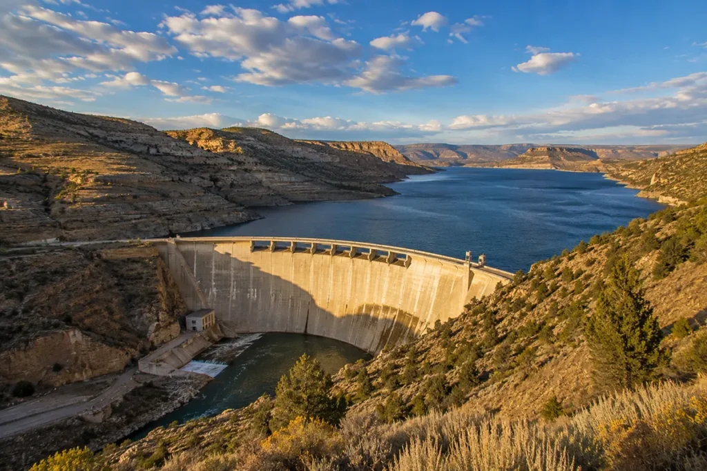
Bighorn Canyon NRA was established by an act of Congress on October 15, 1966, in conjunction with the completion of Yellowtail Dam by the Bureau of Reclamation.
The dam was built primarily for irrigation and hydroelectric power; the recreation area was overlaid on the resulting reservoir to manage the new public access. NPS administers the land; the dam itself is still operated by the Bureau of Reclamation.
The naming is layered. Yellowtail Dam was named for Robert Yellowtail, the influential Crow chairman who led the Crow Tribe through the early-to-mid 20th century. The irony — and it’s not a small one — is that Yellowtail himself opposed the dam’s construction.
He spent decades fighting against the project, which flooded culturally significant Crow lands. Naming the dam after him after his death was either a meaningful gesture of recognition or a final indignity, depending on how you read it.
For broader Montana federal-lands context, see my Montana national parks pillar guide, which covers how Bighorn Canyon fits into the state’s ten NPS-managed sites.
The Two Districts: North vs. South
The most important practical reality of planning a Bighorn Canyon trip: the two districts are not connected by road.
You can drive between them only by exiting one district, driving 3+ hours around through Billings and Sheridan, and entering the other. The only direct route between them is by boat through the canyon itself.
This forces a choice. Which district should you visit?
The North District (Montana — Fort Smith)
Access: Take I-90 from Billings east to Hardin (about 45 minutes), then MT Highway 313 south through St. Xavier to Fort Smith (another 45 minutes). The Yellowtail Dam Visitor Center is just past Fort Smith.
What’s here:
- Yellowtail Dam Visitor Center — overlooks the dam structure, with displays on construction and Crow history
- Yellowtail Dam tours (when offered) — fascinating engineering walk-through
- Afterbay Lake and Afterbay Dam (below the main dam)
- World-class trout fishing on the Afterbay and Bighorn River below
- Ok-A-Beh Marina — boat ramp and access to the lake
- Historic Crow Reservation lands surrounding (with trespass permit requirements — see below)
- Limited hiking; much of the surrounding land is reservation
- Black Canyon Campground
Best for: Anglers (this is the world-class side), boaters launching into the canyon, dam engineering buffs, travelers using Hardin or Billings as a base.
The South District (Wyoming — Lovell)
Access: Take US Highway 14A west from Sheridan, Wyoming, or US Highway 310 south from Billings to Lovell, then north into the recreation area. Note: US 14A includes very steep grades (10% over 10 miles) — not recommended for large RVs.
What’s here:
- Cal S. Taggart Visitor Center in Lovell — the better of the two visitor centers
- Devil’s Canyon Overlook — the iconic 1,500-foot canyon view
- Horseshoe Bend — full marina, swimming beach, boat ramp, campground
- Multiple scenic overlooks with road access
- Most of the 15 hiking trails
- Several historic ranches (Lockhart, Mason-Lovell, others)
- Pryor Mountain Wild Horse Range — adjacent and accessible
- Better photography angles overall
Best for: Photographers, scenic drivers, hikers, wild-horse seekers, first-time visitors.
My Honest Recommendation
If you’re visiting from Montana: Go to the North District first. It’s closer to Billings, the fishing is world-class, and you can do a half-day visit easily.
If you’re chasing the iconic views: Go to the South District. Devil’s Canyon Overlook is the photograph that sells the place, and Horseshoe Bend is the better all-around developed area.
If you have a long weekend: Visit both, but accept that you’re committing to a long loop drive between them via Billings and Sheridan. The boat journey through the canyon between the two is the prettiest connection but requires either your own watercraft or a charter.
The World-Class Fly Fishing
The Bighorn River below Yellowtail Dam and the Afterbay Dam is one of the most prolific trout fisheries in the United States.
The combination of constant cold water releases from the dam (which keep the water at trout-friendly temperatures year-round), the rich limestone-bed substrate, and minimal seasonal fluctuation has created an environment that supports 8,000 to 11,000 trout per mile in the most productive stretches.
That’s not a typo — that’s a density level that approaches what you’d find in a stocked pond.
The fishery:
- Brown trout and rainbow trout dominate the population
- Trophy class fish are common — 18- to 22-inch fish are typical, with regular shots at fish over 25 inches
- Year-round fishing — the river doesn’t freeze; productive even in mid-winter
- The first 3 miles below the Afterbay Dam are the marquee water
- Guides are essential for first-timers — drift boats, expertise on hatches, and access to the productive runs
If you’re a serious fly fisher, this is your trip. The town of Fort Smith — small, no tourist amenities beyond fishing-related — exists almost entirely to support the fly-fishing economy. Multiple guide services operate out of Fort Smith; book months in advance for peak summer dates.
For broader Montana outdoor planning, things to do in Montana covers the wider activity landscape.
The Pryor Mountain Wild Horse Range
Adjacent to the South District is the Pryor Mountain Wild Horse Range — 38,000+ acres managed by the BLM (not NPS) where one of the most genetically distinct wild horse herds in North America still runs free.
The Pryor Mountain mustangs are believed to descend from horses brought by Spanish colonists in the 1500s and represent the closest living link to the original “Indian ponies” of the Plains tribes.
Practical visiting:
- Access via Burnt Timber Ridge Road or Sykes Ridge Road from the South District area
- High-clearance vehicle strongly recommended (4WD ideal)
- Best wildlife viewing in May, June, and September
- Horses can be spotted from public roads or short hikes
- Maintain at least 100 feet distance — they’re wild, not domesticated
The Pryor Mountain Wild Mustang Center in Lovell is the best place to start, with current sighting reports and interpretive information.
The Bad Pass Trail and 10,000 Years of Human History
The canyon and surrounding plateau have been continuously inhabited or used by humans for at least 10,000 years.
The Bad Pass Trail — an ancient route that follows the canyon’s western rim — was used by Indigenous peoples for millennia as the only practical way to traverse the canyon country.
The trail passes pictograph sites, vision quest locations, tipi rings, and other archaeological remnants.
In the fur-trade era (early 1800s), mountain men including Jim Bridger and Jedediah Smith used the Bad Pass route to move pelts between rendezvous sites in the Rockies and the Missouri River trading posts.
The original NPS park road through the South District follows substantial portions of the original Bad Pass Trail.
For the broader Montana historical context, key historical events in Montana and Montana’s history overview cover the wider timeline.
The Crow Reservation Reality
This is where Bighorn Canyon planning gets genuinely complex. Much of the land surrounding the North District — and significant portions adjacent to the recreation area itself — is part of the Crow Indian Reservation. This is sovereign tribal land, not federally accessible without permission.
What this means practically:
- Stay on the marked NPS roads and trails within the recreation area
- Don’t trespass off-trail without a Crow tribal trespass permit
- Trespass permits are available in Crow Agency, Montana (located off I-90 between Hardin and Lodge Grass)
- Don’t fish, hunt, or camp on reservation land without proper tribal authorization
- Respect cultural sites — petroglyphs, vision quest locations, and other archaeological sites are sacred
This is not bureaucratic fussiness — it’s federal law and tribal sovereignty. The Crow Tribe has worked carefully to balance access with cultural preservation; respect that balance.
The Hiking: 15 Trails, 27 Miles
Bighorn Canyon has about 15 maintained trails totaling 27 miles. Most are on the South District side. Highlights:
Devil’s Canyon Overlook (very short) — barely a hike; a short walk from the parking area to the viewpoint. Iconic.
Horseshoe Bend Trail (~1 mile) — easy walking from the campground to a scenic point on the lake.
Sullivan’s Knob Trail (~1.5 miles round-trip) — moderate climb to a ridgeline overlook.
Upper and Lower Layout Creek Trails (~1.5 miles each) — riparian hiking through cottonwood-lined creek bottoms.
State Line Trail (~2 miles one-way) — follows the canyon rim near the Montana-Wyoming border.
Sykes Mountain Trail (~3 miles round-trip, strenuous) — bigger climb with bigger views.
On the Montana side, hiking is limited because of Crow Reservation boundaries. The Afterbay area is the main public-accessible foot-travel zone. Don’t attempt to hike onto reservation land without a permit.
Wildlife at Bighorn Canyon
The wildlife list is high-quality desert/canyon country:
- Bighorn sheep — yes, still in the canyon walls. Mostly seen from boats or scenic overlooks.
- Pryor Mountain mustangs — adjacent to the South District (see above)
- Mule deer — common throughout
- Pronghorn antelope — on the plateaus above the canyon
- Golden eagles — soaring along the canyon walls year-round
- Bald eagles — wintering along the Bighorn River below the dam
- Mountain lions — present but rarely seen
- Prairie rattlesnakes — yes, especially in summer. See my Montana rattlesnakes guide for safety basics.
- Wild turkeys — in the wooded riparian zones
- Beavers, otters, and muskrats — along the Bighorn River below the dam
You won’t see grizzlies or wolves here — wrong ecosystem entirely. But the canyon country wildlife is genuinely diverse. Endangered and threatened species in Montana covers the conservation context.
Best Time to Visit: Month by Month
May: Excellent. Wild horses active, wildflowers, mild temperatures, very light crowds. Montana in May covers the broader picture.
June: Peak greenery, full operations, building crowds (still light by NPS standards). Montana in June.
July–August: Hot. Canyon country can hit 100°F. Fishing remains excellent due to cold dam releases. Hiking is best done at dawn.
September: My favorite month. Cool nights, warm days, dropping crowds, exceptional fishing as fall hatches begin. Montana in September.
October: Great if you catch the right window. Dam releases keep fishing strong. South District becomes very quiet. Montana in October.
November–April: North District remains accessible (Yellowtail Dam visitor center may close); fishing on the Afterbay continues year-round. South District services largely close down. Winter fishing here is genuinely productive but requires preparation for cold weather and remoteness.
For broader Montana seasonal planning, best time to visit Montana covers regional patterns.
Pairing Bighorn Canyon with Other Sites
Bighorn Canyon doesn’t stand alone — it anchors an eastern/south-central Montana loop that most travelers never take.
The Billings-Area Day Trip
Bighorn Canyon’s North District is about 90 minutes from Billings. Combine with Pictograph Cave State Park (ancient Indigenous rock art just outside Billings) for a full day. These two sites together cover 2,000+ years of human history along the Bighorn watershed.
The Eastern Montana NPS Loop (3–4 days)
Bighorn Canyon (North District) → drive east to Miles City → continue to Glendive and Makoshika State Park → loop north to Sidney for Fort Union Trading Post NHS. This is the deepest eastern Montana experience available.
The South-Central Montana History Tour
Bighorn Canyon (either district) → Little Bighorn Battlefield National Monument (just east) → Pompeys Pillar near Billings → Pictograph Cave State Park. Four NPS-related sites in two days, with overnight in Hardin or Billings.
The Wild Horse Detour (South District)
Add a half-day driving the Pryor Mountains for the wild horse herd. Combine with the Bighorn Canyon scenic overlooks for a dedicated South District day.
Personal Tips: What I Wish I’d Known on My First Visit
Plan around district choice first. The 3-hour drive between districts is non-trivial. Decide which one you’re prioritizing before you book lodging.
Cell service is essentially nonexistent in the recreation area. Coverage in Hardin, Lovell, and along the highways is fine; inside the NRA, plan on no signal. Download offline maps before arrival.
Bring binoculars. Bighorn sheep on canyon walls, eagles in the air, wild horses in the distance — much of the wildlife is viewable but distant.
The water is cold even in summer. Releases from Yellowtail Dam come out at around 50°F. Don’t expect warm swimming except near the lake surface.
Fuel up in Hardin or Lovell. Fort Smith has minimal services; the recreation area itself has no fuel. Plan accordingly.
Watch for rattlesnakes on trails. Especially in warm months. Closed-toe shoes, watch your step.
The North District is also the dam tour district. If dam tours are operating (call ahead [verify 2026]), the Yellowtail Dam tour is genuinely impressive engineering — worth half a day on its own.
Stargazing is excellent. Far from major light pollution. Montana’s night sky guide covers the broader dark-sky landscape.
Free admission doesn’t mean low value. Don’t underestimate this place because it’s free. Some of the best NPS experiences in the country are no-cost.
Practical Info Box
| Topic | Quick Answer |
|---|---|
| Entry fee | Free |
| North District access | I-90 to Hardin, then MT 313 south to Fort Smith |
| South District access | US 310 from Billings or US 14A from Sheridan to Lovell, WY |
| Driving distance Billings → North District | ~90 minutes |
| Driving distance Billings → South District | ~2.5 hours |
| Between districts via road | ~3 hours |
| Best fishing access | Afterbay below Yellowtail Dam (North District) |
| Best scenic view | Devil’s Canyon Overlook (South District) |
| Closest airport | Billings Logan (BIL) — see Montana airports |
| Cell service | Essentially none inside the NRA |
| Camping | Multiple campgrounds in both districts; reserve via recreation.gov |
| Closest town with full services | Hardin (North) or Lovell, WY (South) |
| Pair with NPS | Little Bighorn Battlefield, Pompeys Pillar |
| Pair with state park | Pictograph Cave, Makoshika |
Conclusion: The Best-Kept NPS Secret in Montana
Bighorn Canyon is what Montana looks like before the tourism industry gets to it. The scale is real, the fishing is genuinely world-class, the canyon scenery rivals more famous places, and visitor numbers are low enough that solitude is the default rather than the exception. The fact that it’s free to enter — when many NPS sites charge $35/vehicle — feels like a parting gift.
My recommendation: pick a district based on your interests, give it at least a full day (two is better), and treat it as a destination rather than a stopover. If you’re an angler, the North District and the Afterbay should be near the top of your American fishing bucket list.
If you’re a photographer or scenic-driver, the South District and Devil’s Canyon Overlook deserve a half-day with sunrise or sunset light. If you have a long weekend and want to combine, accept the loop drive and split your visit between districts.
This is the deep-dive. For broader Montana parks context:
- Montana national parks pillar guide — Bighorn Canyon in the context of all ten NPS sites
- Montana state parks pillar guide — the state-managed counterpart system
- Glacier National Park and Yellowstone National Park — Montana’s two true National Parks
- Pictograph Cave State Park — natural Billings-area pairing
- Makoshika State Park — eastern Montana pairing
For broader trip planning, see my Montana trip planning guide, things to do in Montana, and the Montana bucket list. Drop questions about district choice, fishing logistics, or wild horse routes in the comments — I’ll answer from experience.
FAQs About Bighorn Canyon National Recreation Area
What is Bighorn Canyon National Recreation Area famous for?
Bighorn Canyon National Recreation Area is famous for its dramatic canyon walls, the Bighorn Lake reservoir, exceptional boating and fishing opportunities, abundant wildlife, and stunning scenic overlooks. The area features some of the most spectacular canyon landscapes in Montana and Wyoming.
Where is Bighorn Canyon National Recreation Area located?
Bighorn Canyon National Recreation Area spans the Montana-Wyoming border. The recreation area follows the Bighorn River and Bighorn Lake, with visitor facilities located near Fort Smith, Montana, and Lovell, Wyoming.
Is Bighorn Canyon worth visiting?
Yes. Bighorn Canyon is one of the most underrated outdoor destinations in the Northern Rockies. Visitors can enjoy breathtaking canyon views, water recreation, wildlife watching, hiking, camping, and historic sites without the crowds found in many national parks.
How deep is Bighorn Canyon?
Bighorn Canyon reaches depths of more than 1,000 feet in some locations. Towering limestone cliffs rise dramatically above Bighorn Lake, creating one of the most impressive canyon systems in the western United States.
What can you do at Bighorn Canyon National Recreation Area?
Popular activities include boating, fishing, kayaking, paddleboarding, camping, hiking, wildlife viewing, photography, scenic driving, horseback riding, and exploring historic ranch sites and archaeological areas.
Can you swim in Bighorn Lake?
Yes. Swimming is permitted in many areas of Bighorn Lake. Visitors often enjoy swimming from beaches, campgrounds, and boat-accessible coves during the warmer months.
What wildlife can you see in Bighorn Canyon?
The recreation area is home to wild horses, bighorn sheep, mule deer, elk, black bears, mountain lions, coyotes, wild turkeys, bald eagles, and numerous other bird species.
Are there wild horses in Bighorn Canyon?
Yes. One of the area’s most popular attractions is the Pryor Mountain Wild Horse Range, where visitors may see free-roaming wild horses living in their natural habitat.
Is there camping at Bighorn Canyon National Recreation Area?
Yes. Several campgrounds are available throughout the recreation area, offering opportunities for tent camping, RV camping, lakeside camping, and backcountry camping.
What is the best time to visit Bighorn Canyon?
Late spring through early fall is the best time to visit. Warm weather allows visitors to enjoy boating, fishing, hiking, and wildlife viewing. Spring and fall also offer pleasant temperatures and fewer crowds.
Do you need an entrance fee for Bighorn Canyon National Recreation Area?
Bighorn Canyon National Recreation Area does not typically charge an entrance fee for general access, though certain activities, camping reservations, or special permits may require fees.
What are the best viewpoints in Bighorn Canyon?
Popular scenic overlooks include Devil Canyon Overlook, Barry’s Landing, and several viewpoints along the canyon rim that offer panoramic views of Bighorn Lake and the surrounding cliffs.
Can you fish at Bighorn Canyon?
Yes. Bighorn Lake and the Bighorn River are known for excellent fishing opportunities. Anglers commonly catch trout, walleye, bass, perch, catfish, and other freshwater species.
How long should you spend at Bighorn Canyon?
A day trip is enough to see major viewpoints, but spending two to three days allows visitors to enjoy boating, hiking, fishing, wildlife viewing, and camping throughout the recreation area.
Why is Bighorn Canyon National Recreation Area important?
The recreation area protects significant natural, cultural, and historical resources, including dramatic canyon landscapes, wildlife habitats, archaeological sites, historic ranches, and important recreational opportunities along the Bighorn River corridor.
Written by Robert Hayes, who has watched bighorn sheep on a canyon wall from a drift boat, caught a 22-inch brown trout on the Afterbay, and lost the same trout 30 seconds later.