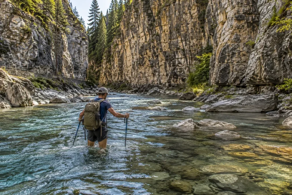
The trail you walk through Sluice Boxes is an old railroad bed. The bridges that once carried trains across Belt Creek have been removed. The trestles that survived have been closed. Which means: to hike this canyon, you ford the creek itself — 16 times if you go the whole way. That’s why almost nobody comes here.
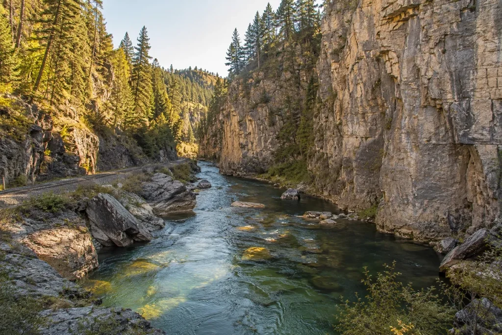
TL;DR: Sluice Boxes State Park preserves the northernmost 8 miles of the spectacular Belt Creek Canyon — a limestone slot between cliff walls in the Little Belt Mountains south of Great Falls. The trail follows the old Central Montana Railroad bed; the bridges are gone, so hikers must ford Belt Creek up to 16 times to complete the full thru-hike. The Tiger Creek trestle is currently closed, making a complete thru-hike impossible — most visitors do an out-and-back of varying length from the Riceville Bridge trailhead. Best hiked mid-July through September when water is lowest. World-class blue-ribbon trout fishing. Remnants of mining-era cabins and railroad infrastructure throughout. Almost no crowds.
I’m Robert Hayes, and I’ve hiked the Sluice Boxes in late August more than once. The canyon is one of those Montana places that doesn’t show up on most tourism marketing — partly because the access is committed (you’ll get your feet wet), partly because the through-hike has been complicated by trestle closures for several years, and partly because most travelers stick to the easier, more developed state parks. Their loss.
This is the deep-dive on Sluice Boxes. For the broader Montana state parks landscape, see my Montana state parks pillar guide.
The natural pairing in central Montana is Giant Springs State Park — together they make a full day of state-park experience from a Great Falls base. For broader trip planning, my Montana national parks pillar guide covers the federal-lands context.
Quick Stats
| Stat | Detail |
|---|---|
| Park size | 1,454 acres |
| Elevation | 4,035 feet |
| Canyon depth | Up to 600+ feet of cliff walls |
| Location | Little Belt Mountains, 15 miles south of Belt on US Highway 89 |
| Trail beginning (developed access) | Riceville Bridge trailhead |
| Trail end (no facilities) | Logging Creek Bridge |
| Full thru-hike distance | ~7.5–8.7 miles (one-way) |
| Creek crossings (full thru-hike) | 16 |
| Tiger Creek trestle | Closed — through-hike not currently possible [verify 2026] |
| Established as state park | 1974 |
| Annual visitors (2023) | ~31,500 (one of Montana’s least-visited state parks) |
| Belt Creek fishing | Blue-ribbon trout stream |
| Day-use fee [verify 2026] | Free for residents; non-resident state park pass applies |
| Camping | Backcountry / primitive only |
| Best hiking months | Mid-July through September (low water) |
| Worst hiking months | March–June (high water makes crossings dangerous) |
Why “Sluice Boxes”?
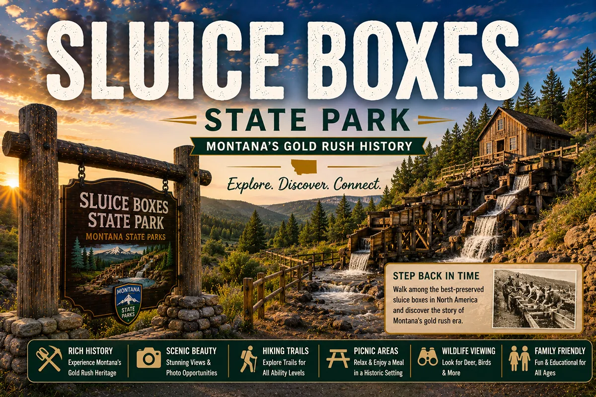
The name throws people. A sluice box is a piece of gold-mining equipment — a long wooden trough with internal ridges called “riffles” that catch heavier gold particles as water and gravel wash through. Placer miners used them on streams across the West.
Belt Creek Canyon got the name from the mining era, when prospectors worked the gravels and gulches throughout the Little Belt Mountains.
The canyon itself was likened to a giant natural sluice box — Belt Creek functioning like the water flow that washes gravel through the device, with the cliffs and canyon walls acting like the wooden sides. The metaphor stuck even after the placer mining wound down.
The naming reflects the area’s primary history: this was mining country before it was anything else.
The Mining Era and the Railroad
In the late 1800s, the Little Belt Mountains experienced a substantial mining boom. The towns of Monarch, Neihart, Hughesville, and Albright grew rapidly to support silver and lead mining operations. At its peak, Neihart alone had over 1,000 residents and full town infrastructure.
The Central Montana Railroad — a Great Northern subsidiary — built a narrow-gauge line up Belt Creek Canyon specifically to haul ore from the mines.
The line crossed Belt Creek dozens of times via a series of timber trestles, threading the impossible canyon terrain with a railroad. The track followed every twist of the canyon because there was nowhere else to put it.
When mining declined in the early 1900s, the trains kept running for a while on a different cargo: fishermen.
The “fishing trains” of the 1920s: After Belt Creek was designated a blue-ribbon trout stream, the Central Montana Railroad began running special Sunday fishing trains in the 1920s, dropping anglers at various points along the canyon and picking them up later in the day. For roughly a decade, the canyon hosted weekend fly-fishing tourism via a railroad whose primary purpose was supposed to be ore transport.
The mining eventually played out. The railroad shut down. The trestles aged. By the time Montana FWP designated Sluice Boxes a state park in 1974, the rail line was already long defunct.
The state inherited the railroad bed as a hiking corridor, with the original trestles either collapsed or condemned. Today, the rail grade you walk follows essentially the same route the fishing trains did a century ago — but you’re on foot, and you’re crossing the creek the old-fashioned way.
For broader Montana mining history context, see my Montana gold rush guide, and for the broader state park system, my Montana state parks pillar guide.
Today’s ghost towns: Most of the mining-era settlements are gone or nearly gone. Monarch and Neihart survive as small recreational communities (you’ll pass them on Highway 89 driving to the park). Hughesville and Albright are ghost towns — abandoned, with only foundations and a few standing structures remaining. Inside Sluice Boxes itself, you’ll find remnants of cabins, old mine adits, and railroad infrastructure throughout the canyon.
The Trail: What You’re Actually Walking
The Sluice Boxes Trail is unique among Montana state park trails for one reason: the bridges are gone. The original rail line crossed Belt Creek roughly 16 times via timber trestles.
When the railroad was abandoned and the trestles deteriorated, they were either removed or fenced off. To complete the full canyon hike, you ford the creek at each former crossing point.
The Current Status (2026)
The Tiger Creek trestle is closed. This is the critical current-conditions fact. The Tiger Creek trestle is one of the surviving structures within the park, and Montana FWP has closed it to foot traffic for safety reasons.
The closure means a complete thru-hike of the canyon from Riceville Bridge to Logging Creek Bridge is not currently possible.
What you CAN do:
- Out-and-back hikes of varying length from the Riceville Bridge trailhead, fording creek crossings as far as conditions allow
- Day-hikes of 2–6 miles round-trip to specific scenic points in the canyon
- Fishing access at the Riceville Bridge area
What you CANNOT currently do:
- Complete the original 7.5-mile thru-hike from Riceville to Logging Creek
- Use the Tiger Creek trestle for through-passage
[verify current trestle status with Montana FWP before planning] — FWP sometimes restores closed trestles, and conditions change.
The Developed Trailhead: Riceville Bridge
This is the only developed access point for Sluice Boxes. You’ll find:
- A parking area
- Latrine (vault toilet)
- Trailhead signage
- Belt Creek fishing access
- Picnic spots
From here, the trail follows the old rail grade upstream (south) along Belt Creek. The first half-mile is relatively easy — relatively flat terrain on the old railroad bed. Then the creek crossings begin.
The Creek Crossings: Real Logistics
This is the part most visitors are unprepared for. Some honest specifics:
Water depth: Crossings typically range from ankle-deep to mid-thigh-deep depending on water level and which crossing. Late season (August–September) is shallowest. Several crossings reach above the knee even in low water.
Water temperature: Belt Creek is spring-fed and runs 50°F or colder year-round. Not “refreshing” — actually cold. Numbness in feet and lower legs after the first few crossings is normal.
Footing: Streambed is mixed cobble and gravel. Slick algae on some rocks. Footing is uneven.
Required gear:
- Water shoes or sturdy sandals (Tevas, KEEN water sandals, or similar). Hiking boots will be soaked.
- Trekking poles — strongly recommended. The current is moderate, the footing is uneven, and balance is critical.
- Dry bag for camera, phone, valuables
- Quick-dry pants — wet jeans for 5+ miles isn’t sustainable
- Towel and dry socks for after
Honest assessment: If you don’t like wet feet, this is not your park. If wet feet sound like part of the adventure, you’ll enjoy this enormously.
What You’ll See Inside the Canyon
Beyond the creek crossings themselves, the canyon scenery is the draw:
The limestone cliff walls — Madison Limestone, gray to buff in color, with walls rising 200 to 600+ feet on either side of the canyon at various points. This is the same limestone formation that contains Lewis & Clark Caverns further south — both parks expose the regional bedrock that defined much of central Montana’s mining geology.
Old mining remnants — Stone foundations, log cabins in varying states of decay, mine adits (horizontal entrances) cut into the canyon walls, and rusted ironwork scattered along the rail grade. The remnants of Riceville and Albright (mining-era settlements that disappeared) are within or near the park boundaries.
Hidden waterfalls — Side creeks drop into Belt Creek from the canyon rim. A particularly photogenic 60-foot waterfall sits along one of the upper canyon sections — viewable from a narrow ledge trail that branches off the main rail bed.
Wildlife — Mountain lions, black bears, mule deer, elk in the upper canyon, golden eagles soaring above the rim, and the dippers (American dipper birds) that hunt aquatic insects underwater along Belt Creek itself.
Cliff-jumping spots — Several deep pools along Belt Creek have rocky perches above them — informal cliff-jumping locations where local visitors leap into the cold water. About 30 feet of drop at the most popular spot. Jump at your own risk; the water is shockingly cold and the depth varies seasonally.
The Fishing
Belt Creek is a designated blue-ribbon trout stream — Montana’s highest fishing-water classification, denoting world-class conditions for trout fishing. Inside the canyon, brown trout and rainbow trout populations are healthy, sizes are good (12–18 inches typical, with regular shots at fish over 20 inches), and access is limited enough that you can fish water that hasn’t seen another angler all day.
Conditions:
- Spring-fed cold water year-round
- Constant flow (good for trout habitat)
- Pocket water, riffle-pool sequences, and deep holes throughout
- Best fly fishing from late June through September
Access: The Riceville Bridge trailhead is the primary fishing access. Walk-in fishing further into the canyon is excellent but requires creek crossings (so same gear logistics apply as for hiking).
Regulations: Standard Montana FWP regulations apply; check current limits and seasons.
When to Visit: The Tight Window
This is one of the most seasonal state parks in Montana.
March–early June: AVOID for hiking. Belt Creek runs high with spring snowmelt — crossings range from dangerous to impossible. Spring runoff peaks in May. Fishing access is fine from the Riceville Bridge area, but don’t attempt creek crossings.
Late June–early July: Water starting to drop. Crossings still high but possible for experienced waders. Wildflowers blooming. Montana in June and Montana in July cover broader trip context.
Mid-July through September: The optimal window. Water at its lowest, crossings most manageable, weather generally dry and warm. This is when locals do the Sluice Boxes hike. Montana in August and Montana in September.
October: Possible but increasingly cold. Hunting season activity in surrounding forest. Beautiful larches turning in the higher Little Belts. Montana in October.
November–February: Trail access exists; creek crossings essentially impossible due to ice. Excellent for cross-country skiing on the rail-grade sections that don’t require fording. Montana winter weather covers the broader context.
Personal Tips: What I Wish I’d Known on My First Visit
Do an out-and-back, not a thru-hike. Especially with the Tiger Creek trestle closed. Walk in from Riceville Bridge as far as you want, fording crossings until you’ve had enough or you reach a barrier, then return. Most visitors do 2–4 miles out and back.
Plan for cold water and wet gear all day. Bring towels and a complete change of clothes in your car for after the hike. Drive home in dry stuff.
Lock your car and don’t leave valuables visible. The Riceville Bridge trailhead is remote and lightly patrolled.
Cell service is essentially nonexistent inside the canyon. Download offline maps before driving in.
The drive from Belt is more scenic than expected. US Highway 89 from Belt south is part of the Kings Hill National Scenic Byway. The 15-mile drive to the trailhead is beautiful.
Belt itself is worth a stop. [verify current businesses] The town has a small downtown with character, a brewery, and Montana’s oldest active mining-era buildings still in use. Stop in either before or after the hike.
Don’t underestimate the difficulty. AllTrails rates the easier sections as “moderate” — but moderate doesn’t account for the 50°F creek crossings or the lack of trail maintenance in places. Treat this as a backcountry hike, not a park stroll.
Bear country awareness. Black bears are common; grizzlies are present but rare. My Montana bear guide covers what to carry. The canyon has limited escape routes if you encounter a bear, so awareness matters.
Photography tips: Polarizing filter for the water and limestone. Best light is mid-morning when sun finally clears the canyon rim, or late afternoon when shadows are long.
Refuel in Belt or Great Falls. No fuel or food at the trailhead; minimal options in Monarch or Neihart.
Pair with Central Montana Sites
Sluice Boxes works well as either a half-day or a centerpiece of a 2–3 day central Montana visit.
The Great Falls State Parks Day
Giant Springs State Park in the morning + Sluice Boxes hike in the afternoon. About an hour drive between them. This is the ideal central Montana state-park combination — one developed, one wild; one accessible, one challenging; together they show the range of the Montana state park system.
The Kings Hill Scenic Byway
US Highway 89 from Belt south through Sluice Boxes continues up over the Kings Hill Pass (7,393 feet) and down into White Sulphur Springs. The full scenic byway is 71 miles and arguably the most underrated drive in central Montana. Build a half-day or full day around it.
The Mining-Era Ghost Town Loop
Sluice Boxes → drive south through Monarch and Neihart on Highway 89 → continue to Hughesville and Castle Town (ghost-town remnants) → eventually connect to Bannack State Park further south. This is the deepest central-Montana mining-history loop available.
The Great Falls Multi-Day
Use Great Falls as a 3-night base. Day 1: Giant Springs + Lewis & Clark Interpretive Center. Day 2: Sluice Boxes hike. Day 3: First Peoples Buffalo Jump State Park + C.M. Russell Museum. This is one of Montana’s most underrated multi-day destinations.
Pair with Other State Park Children
For the broader cluster, consider:
- Best central-Montana pairing: Sluice Boxes + Giant Springs — the wild canyon and the developed urban park, both within an hour of Great Falls
- Best for solitude lovers: Sluice Boxes + Makoshika State Park — Montana’s two emptiest, most distinctive state parks (limestone canyon and badlands)
- Best for geology: Sluice Boxes + Lewis & Clark Caverns — both expose the regional Madison Limestone in dramatically different ways
- Best for history depth: Sluice Boxes + Bannack State Park — mining-era infrastructure (rail grade) plus territorial-era town
Practical Info Box
| Topic | Quick Answer |
|---|---|
| Trail length | Up to 7.5–8.7 miles thru-hike (currently impossible due to trestle closure) |
| Out-and-back options | 2–6 miles round-trip from Riceville Bridge |
| Creek crossings (full thru-hike) | 16 |
| Best months | Mid-July through September |
| Avoid months for hiking | March–early June (high water) |
| Required gear | Water shoes, trekking poles, dry bag, layers |
| Water temperature | ~50°F year-round |
| Day-use fee | Free for residents; non-resident pass applies [verify 2026] |
| Camping | Backcountry only (no developed sites) |
| Closest town | Belt (15 miles north) |
| Closest larger town | Great Falls (45 miles northwest) |
| Closest airport | Great Falls International (GTF) — see Montana airports |
| Cell service | Essentially nonexistent inside the canyon |
| Current trestle status | Tiger Creek trestle closed; through-hike NOT possible [verify 2026] |
| Pair with state park child | Giant Springs, Lewis & Clark Caverns, Makoshika |
Conclusion: Montana’s Quietest Limestone Canyon
Sluice Boxes is one of Montana’s most distinctive state parks specifically because it’s hard to do. The 16 creek crossings, the closed trestle, the 50°F water, the absence of facilities — all of it functions as a filter that keeps casual visitors away.
What remains is one of the most dramatic limestone canyons in the West, a working blue-ribbon trout stream, mining-era ruins scattered throughout, and the kind of solitude that’s increasingly rare on public land.
My recommendation: don’t attempt the full thru-hike (it’s not currently possible anyway). Drive to the Riceville Bridge trailhead in late August. Wear water shoes.
Hike in 2–4 miles, fording creek crossings as you go, until you find a quiet pool to fish or photograph or just sit beside. Eat a packed lunch. Hike back out. You’ll have spent the day in a canyon that should be famous but isn’t — and you’ll likely have it almost entirely to yourself.
This is the deep-dive. For broader context:
- Montana state parks pillar guide — all 55+ state parks and how to choose
- Montana national parks pillar guide — federal counterpart system
- Giant Springs State Park — the natural Great Falls-area pairing
- Great Falls hub — the city base for a central-Montana visit
- Montana gold rush — the broader mining-era context
- Things to do in Montana and Montana bucket list — broader trip planning
Drop questions about creek-crossing logistics, current trestle status, or the fishing in the comments — I’ll answer from experience.
FAQs About Sluice Boxes State Park
What is Sluice Boxes State Park famous for?
Sluice Boxes State Park is famous for its dramatic limestone canyon, rugged hiking trails, scenic waterfalls, historic railroad tunnels, and the beautiful Belt Creek that flows through the park. It is considered one of Montana’s hidden gems for outdoor adventure.
Where is Sluice Boxes State Park located?
Sluice Boxes State Park is located in central Montana near the town of Belt, approximately 30 miles southeast of Great Falls. The park lies within a spectacular canyon carved by Belt Creek.
Is Sluice Boxes State Park worth visiting?
Yes. Sluice Boxes State Park offers stunning canyon scenery, unique geological features, historic railroad remnants, and excellent opportunities for hiking, fishing, photography, and wildlife viewing.
Why is it called Sluice Boxes State Park?
The park’s name comes from the narrow canyon sections where Belt Creek rushes between steep rock walls, resembling the sluice boxes once used by miners during Montana’s gold rush era.
What are the best things to do at Sluice Boxes State Park?
Popular activities include hiking through the canyon, exploring old railroad tunnels and trestles, fishing in Belt Creek, birdwatching, photography, picnicking, and enjoying the park’s dramatic scenery.
Are there hiking trails in Sluice Boxes State Park?
Yes. The park is best known for its hiking opportunities. Trails follow the old railroad grade through the canyon, passing waterfalls, rock formations, bridges, and historic railroad structures.
How difficult is hiking at Sluice Boxes State Park?
Trail difficulty ranges from moderate to challenging depending on water levels, weather conditions, and the route chosen. Some sections may require crossing shallow creek areas or navigating uneven terrain.
Can you fish in Sluice Boxes State Park?
Yes. Belt Creek is a popular fishing destination, particularly for trout anglers. Visitors should follow Montana fishing regulations and licensing requirements.
Are there waterfalls in Sluice Boxes State Park?
Yes. Seasonal waterfalls can be found throughout the canyon, especially during spring and early summer when snowmelt increases water flow.
Is camping available at Sluice Boxes State Park?
The park does not have developed campgrounds within its boundaries. However, camping opportunities are available on nearby public lands and in surrounding recreation areas.
What wildlife can be seen at Sluice Boxes State Park?
Visitors may encounter mule deer, elk, black bears, mountain lions, bighorn sheep, hawks, eagles, and a variety of songbirds and other wildlife native to central Montana.
What is the best time to visit Sluice Boxes State Park?
Late spring through early fall is the best time to visit. Spring offers flowing waterfalls and lush scenery, while summer and fall provide excellent hiking conditions and pleasant weather.
Are dogs allowed in Sluice Boxes State Park?
Yes. Dogs are generally allowed in the park but should be kept under control and owners should follow all state park regulations regarding pets and wildlife protection.
How much time should you spend at Sluice Boxes State Park?
Most visitors spend a half day to a full day exploring the canyon. Serious hikers and photographers may choose to spend even longer enjoying the park’s scenic and historic features.
What makes Sluice Boxes State Park unique?
Sluice Boxes State Park combines rugged canyon landscapes, historic railroad remnants, waterfalls, wildlife, and outdoor recreation in a relatively uncrowded setting, making it one of Montana’s most distinctive state parks.
Written by Robert Hayes, who has hiked Sluice Boxes with cold feet in August and isn’t apologetic about wet socks.