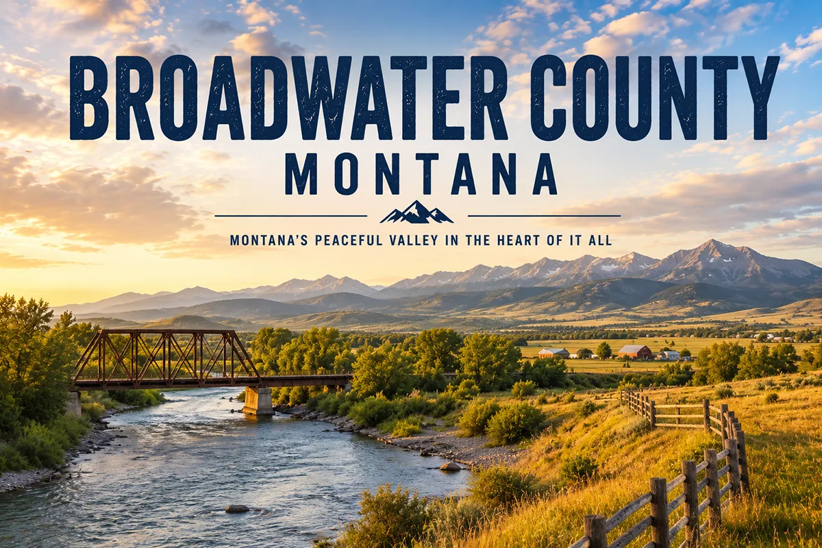
I almost drove through Broadwater County a dozen times before I finally stopped.
The stretch of US-287 between Helena and Three Forks looks like a lot of Montana highway from the car — valley, mountains, river — and it’s easy to keep going.
Then you actually turn off and spend a day at Canyon Ferry Lake. And suddenly you understand why Montanans from four different cities treat this reservoir like their personal backyard.
- Broadwater County covers 1,239 square miles in west-central Montana, nestled between the Big Belt and Elkhorn mountain ranges
- The county seat is Townsend (~2,000), nicknamed “the Front Door to Canyon Ferry”
- Canyon Ferry Lake is Montana’s third-largest body of water and the state’s most-used recreation reservoir — boating, walleye fishing, ice sailing, camping, and swimming across 24 BOR sites
- The Lewis & Clark Expedition traveled through in July 1805, setting up nine campsites along the Missouri River corridor
- Canton Church — a National Historic Register Gothic Revival church — was moved when the reservoir flooded its original community, which now lies at the bottom of Canyon Ferry Lake
- The Spokane Bar Sapphire Mine lets visitors dig their own Montana sapphires on the shores of Hauser Lake
- Goosebay Handblown Glass in Townsend is one of Montana’s best artisan studio experiences
- The Big Belt Mountains offer accessible hiking, mountain goat terrain, and views over Canyon Ferry from peaks reaching 9,500 feet
- ⚠️ Competitor factual error to know: discoveringmontana.com calls Broadwater “the largest county in the state” — it’s not. Broadwater is 1,239 sq mi; Beaverhead County (5,542 sq mi) is the largest
Broadwater County at a Glance
Broadwater County was established in 1897, carved from parts of Jefferson and Meagher counties.
It’s named for Charles Arthur Broadwater — a 19th-century Montana powerbroker who built fortunes in railroad development, real estate, and banking. He also built the famous Broadwater Hotel and Natatorium in Helena (now demolished), which was once considered one of the grandest resort hotels in the American West.
The county’s geography is defined by two mountain ranges and a river.
The Big Belt Mountains form the eastern and northern boundary. The Elkhorn Mountains rise to the west. Between them, the Missouri River flows northward through a valley that Townsend residents sometimes call the “Banana Belt” — a local nickname for the mild microclimate that keeps the valley noticeably warmer than surrounding areas in winter.
Population is around 7,793 (2022 estimate) — small for a county this close to Helena, which sits just 38 miles north.
The county’s main visitor draw is Canyon Ferry Lake, but there’s considerably more to explore once you get off the highway.
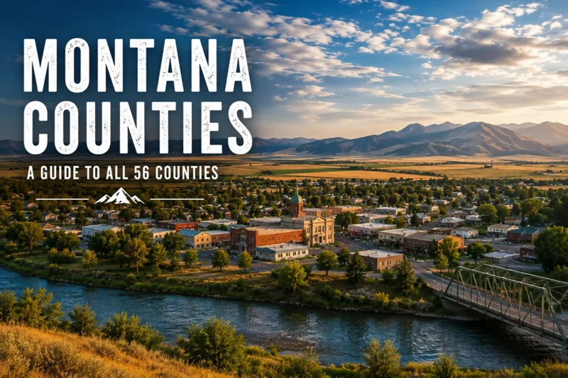
For broader Montana context, see the complete guide to all 56 Montana counties. For the full Townsend travel guide, see Townsend, Montana.
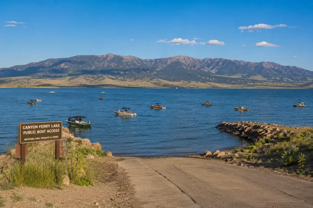
Canyon Ferry Lake
Canyon Ferry Lake is the kind of recreation area that Montanans take for granted because they’ve been coming here since childhood.
The reservoir was created in 1954 when the Bureau of Reclamation dammed the Missouri River as part of the Pick-Sloan Missouri Basin Program. The resulting lake covers 33,534 acres, stretches roughly 25–30 miles in length, and has 76 miles of shoreline.
It’s Montana’s third-largest body of water — and by the Bureau of Reclamation’s own accounting, the state’s most-used recreation reservoir.
What you can do on the lake:
Fishing is the primary draw for most visitors. Walleye, rainbow trout, brown trout, kokanee salmon, and perch are all present.
Walleye fishing in particular is outstanding — the annual Canyon Ferry Walleye Festival in summer draws competitive anglers from across the region. [Verify current festival dates with the Townsend Chamber of Commerce.]
Boating ranges from kayaks and canoes to full-size motorboats and jet skis. There are multiple boat launches around the lake.
Ice sailing is a winter activity that’s genuinely unusual — Canyon Ferry is one of the few lakes in Montana where conditions reliably support ice yacht racing. The sight of a sail-equipped ice craft crossing a frozen reservoir at speed is something you don’t forget.
Ice fishing rounds out the winter options, with walleye and perch as the main targets.
The Bureau of Reclamation manages 24 recreation sites around the lake. Camping is available at most sites and fills quickly on summer weekends — arrive Thursday or book early.
The Lewis & Clark Expedition in Broadwater County
The Corps of Discovery traveled through what is now Broadwater County in late July 1805, moving upriver on the Missouri toward the Continental Divide.
Progress was maddeningly slow — the Missouri was shallow and fast here, requiring the men to wade, tow, and pole the canoes upriver in summer heat. The captains recorded the difficulty in their journals with barely concealed frustration.
On July 22, 1805, Sacajawea recognized the white clay banks east of present-day Winston, Montana. Her people had visited these banks in her childhood to gather the clay for pigment. It was a critical confirmation that the expedition was approaching familiar Shoshone country — and that horses and a mountain guide were within reach.
Between Canyon Ferry Dam and the Toston Dam south of Townsend, Lewis and Clark set up nine campsites along this short stretch of river.
Their journals from this section mention specific landmarks they named: Onion Island, Crimson Bluffs, York’s Island, Fine Bold Springs, and the “Little Gates of the Mountains.”
You can trace the Lewis & Clark corridor along the Missouri River corridor through the county — interpretive signage at several access points along Canyon Ferry Lake and at Toston Dam explains the expedition’s specific movements through the valley.
See key historical events in Montana for broader expedition context.
Canton Church: A Community Beneath the Water
One of the most striking stories in Broadwater County barely gets mentioned in standard travel guides.
When Canyon Ferry Dam was completed in 1954, the rising reservoir flooded the small community of Canton — including homes, farms, and the historic Canton church.
The church — St. Joseph’s Canton Church — was spared by being relocated to higher ground before the water came. It’s a Gothic Revival structure, listed on the National Historic Register, and is considered the third church built in Montana.
It now sits near the northeast shore of Canyon Ferry Lake, serving as a community center with live performances and events through the summer season.
Driving by it on Highway 284 along the east shore, knowing that the community it served now sits below the water, gives the building an affecting quality that goes well beyond its architectural interest.
The church is worth a deliberate stop — not just a drive-past.
Spokane Bar Sapphire Mine
The Spokane gravel bar on the shores of Hauser Lake (just north of Canyon Ferry Lake) has been producing sapphires since the gold rush era.
Miners searching for gold in the gravel bar instead found heavy stones — and eventually, blue and multi-color sapphires in a concentration that’s still producing today.
The Spokane Bar Sapphire Mine lets visitors dig through the rough gravel with provided tools and keep what they find. It’s open in summer daily [verify current hours at spokanebarmine.com].
The sapphires found here range from pale blue to rich blue, green, yellow, and parti-color varieties. They’re not always immediately recognizable as gems in raw form — most look like tiny stones until cut and polished.
If you’re planning to dig, bring sunscreen, wear clothes you don’t mind getting dirty, and manage your expectations for a single session. Experienced diggers come back multiple times.
For context on Montana’s sapphire heritage, see Montana sapphires and gemstone mining in Montana.
Goosebay Handblown Glass
Goosebay Handblown Glass in downtown Townsend is the kind of artisan experience that doesn’t fit neatly into a standard travel category — and is better for it.
Glassblower Mark Gunderson works with molten glass at temperatures around 2,000°F, shaping vessels, art glass, and decorative pieces using traditional techniques. Visitors can watch the process through the studio windows.
I’ve watched glassblowing demonstrations at a handful of places around the country. This is the real thing — not a staged demo but an actual working studio where the work is constantly happening.
The shop sells finished pieces, which make genuinely memorable gifts. Nothing comes cheap, but everything is one-of-a-kind.
Goosebay is located in downtown Townsend. [Verify current hours and studio visiting times before your trip.]
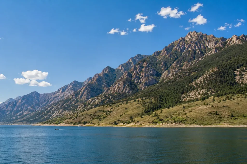
The Big Belt Mountains
The Big Belt Mountains rise from the eastern shore of Canyon Ferry Lake and form Broadwater County’s eastern and northern boundary.
They’re not as famous as the Beartooths or the Missions, but they’re accessible and genuinely rewarding for hikers willing to make the drive up Duck Creek Pass Road from the east side of the lake.
From Duck Creek Pass, trails head north along the ridgeline toward Boulder Mountain (8,810 ft) and Boulder Baldy (8,942 ft), two miles apart. The approach is gradual along the ridge; the descent to the twin Boulder Lakes on the north side is steep.
Hiking south from Duck Creek Pass leads toward Mt. Baldy (9,181 ft) and then four miles further to Mt. Edith at 9,504 ft — where mountain goats frequent the tundra-like terrain near the summit.
The 30,000-acre Camas Creek Roadless Area within the Big Belts provides one of the most accessible wilderness-adjacent experiences in the Helena vicinity.
Summer wildflowers, reliable mountain goat sightings, and sweeping views over Canyon Ferry Lake make the Big Belts an underrated day hike from Townsend.
Elkhorn Mountains
The Elkhorn Mountains rise to the west of Townsend and form the county’s western boundary.
They’re part of the Helena National Forest and offer a different experience from the Big Belts — lower elevation, more forest, and easier access from the Townsend valley floor.
Multiple trails access the Elkhorns directly from the edge of town. Elevations top out around 9,400 ft, with views over Canyon Ferry Lake and the Missouri Valley on clear days.
The Elkhors are especially good for families and beginning hikers — the approaches are shorter and less exposed than the Big Belt high routes.
Canyon Ferry Wildlife Management Area
The Canyon Ferry Wildlife Management Area covers nearly 6,000 acres at the northern end of the reservoir, where the Missouri River empties into Canyon Ferry Lake.
The river’s entrance creates a series of wetlands and waterfowl ponds that draw exceptional birdlife.
What wildlife to expect:
Spring and fall migration brings large numbers of waterfowl through the management area. The area is managed specifically for ducks, geese, pheasants, and other upland birds.
Moose are present year-round — the willows and cottonwoods along the river edge provide excellent browse habitat. White-tailed deer, beaver, raccoon, red fox, and the occasional otter complete the mammal roster.
Winter bald eagle viewing is one of Broadwater County’s most underrated experiences. Large concentrations of bald eagles gather near Canyon Ferry from November through December, drawn by open water and late-season fish. The area around York Road north of the dam is the primary viewing zone.
The management area is accessible year-round via road and foot trails. The Indian Road Campground sits at the southern edge and provides a base for multi-day wildlife observation trips.
Missouri River Canoe Float
The stretch of the Missouri River south of Canyon Ferry Dam is one of the best easy floats in this part of Montana.
The classic run starts at the Toston Bridge south of Townsend on US-287. From there, it’s 15 river miles to the Indian Road Campground — a good take-out point on the Canyon Ferry Wildlife Management Area’s southern edge.
The float is gentle and suitable for canoes and kayaks. Current is moderate and river hazards are minimal on this stretch.
The corridor passes through cottonwood-lined banks with good bird and wildlife habitat throughout. No whitewater, no technical sections — just a quiet float through classic Missouri River valley scenery.
Several campgrounds with launch access are also visible along Highway 287 for shorter out-and-back floats.
Copper City Mountain Biking Trails
The south part of Broadwater County holds the Copper City Mountain Biking Trail system — a network that’s highly regarded by local riders and almost completely unknown to out-of-state visitors.
Trails run through the Elkhorn foothills with varied terrain suitable for intermediate and advanced riders.
The trailhead is accessible from Townsend. [Verify current trail access and conditions with the Townsend visitor center before your trip.]
Wheat Montana Bakery
No drive through Broadwater County on US-287 is complete without stopping at Wheat Montana Farm and Bakery.
The Wheat Montana operation sits directly on US-287 north of Three Forks, at the county’s southern border.
It’s a full-scale working grain farm with a bakery that makes fresh breads, rolls, pastries, and sandwiches using wheat grown on the property. The whole wheat bread is exceptional.
Montana road trips involve a lot of gas station food by default. Wheat Montana is a reliable, excellent alternative for stocking up on actual food before heading into a less-serviced area.
The deli counter is worth a stop even if you’re not buying bread. [Verify current hours at wheatmontana.com.]
Townsend: The County Seat
Townsend (~2,000) sits at the south end of Canyon Ferry Lake on US-287, 38 miles south of Helena.
It’s a functional, pleasant small town — the kind that doesn’t have a lot of tourist infrastructure but has what you actually need: gas, groceries, a few restaurants, motels, and the Broadwater County Museum.
The Canyon Ferry Brewing Company is a local craft brewery worth a visit. Deep Creek Pizza is the go-to for a casual dinner. Bread & Butter Cafe handles breakfast and lunch well.
The Broadwater County Museum covers local history from the Lewis & Clark era through the Canyon Ferry Dam construction, with Pioneer-era artifacts and rotating exhibits. It’s a good orientation stop before heading to the lake or the mountains.
The town nickname “the Banana Belt” refers to the valley’s microclimate — winters here are measurably milder than Helena (38 miles north) and noticeably warmer than higher elevation communities to the east and west.
For the full Townsend visitor guide, see Townsend, Montana.
What I Wish I Knew Before Visiting Broadwater County
The reservoir fills fast on summer weekends. Canyon Ferry’s 24 BOR campgrounds are first-come, first-served for most sites. If you’re arriving on a Friday in July or August, you may find the popular spots taken. Arrive Thursday or call ahead to check conditions.
The east-shore drive (Highway 284) is better than the west. Most travelers default to US-287 on the west side of the lake. Highway 284 on the east shore is less-traveled, more scenic, and passes Canton Church. Build it into a loop.
Goosebay Glass isn’t always open. It’s a working studio, not a retail store on a set schedule. Check their hours before planning your day around it.
Bald eagle season is November–December. If you’re visiting in late fall, add the Canyon Ferry Wildlife Management Area to your itinerary specifically for eagle viewing — it’s exceptional.
The Banana Belt is real but not absolute. Winters in Townsend are milder than much of Montana, but “milder” is relative. Check road conditions before making the drive from Helena in a winter storm. See Montana winter driving guide.
Don’t skip the Big Belts because the drive looks long. The Duck Creek Pass Road approach takes some commitment. But the combination of mountain goats, ridge walking, and Canyon Ferry Lake views from 9,000+ feet is worth every minute of the drive.
The competitor page calls Broadwater the largest county in Montana. It isn’t. Beaverhead County (5,542 sq mi) is the largest. Broadwater is 1,239 sq mi — the 36th-largest county in Montana. Don’t plan your trip based on that description.
Practical Info
| County seat | Townsend |
| Area | 1,239 sq mi |
| Population | ~7,793 (2022 est.) |
| Tourism region | Gold West Country (Southwest Montana) |
| Formed | 1897 |
| Main highways | US-287 (north-south), US-12 (east-west) |
| Canyon Ferry Lake | 30 miles long, 76 mi shoreline, 24 BOR rec sites |
| Nearest city | Helena (~38 miles north via US-287) |
| Nearest airport | Helena Regional Airport (~45 miles north) |
| Best season | May–October for lake recreation; Nov–Dec for bald eagles |
| Fishing | Walleye, trout, kokanee, perch year-round |
| Sapphire mine | Spokane Bar Sapphire Mine — summer daily [verify hours] |
| Cell service | Good in Townsend and on US-287; variable on lake shore |
| Gas/services | Townsend main hub; limited around the lake perimeter |
Getting to Broadwater County
From Helena: US-287 south from Helena — 38 miles, about 40 minutes to Townsend.
From Bozeman: I-90 west to US-287 north at Three Forks — about 50 miles, roughly 55 minutes.
From Butte: I-90 east to US-287 north at Three Forks, or I-15 north to Helena then US-287 south — 1 to 1.5 hours depending on route.
By air: Helena Regional Airport (HLN) is the nearest commercial airport with regular service from Denver, Salt Lake City, and Seattle.
See Montana airports and Montana transportation guide.
Towns in Broadwater County
- Townsend — county seat, Canyon Ferry gateway, full visitor services
- Winston — small community north of Townsend where Sacajawea recognized the white clay banks in 1805
- Toston — small community on the Missouri River south of Townsend; access for the Toston Dam and river float
- Radersburg — historic small community in the Horseshoe Hills area; former mining area
Adjacent Counties
- Lewis and Clark County to the north and northwest — Helena, state capital
- Meagher County to the northeast — White Sulphur Springs, Smith River
- Wheatland County to the east — Harlowton
- Gallatin County to the south — Bozeman, Three Forks
- Jefferson County to the southwest — Boulder
Plan Your Broadwater County Trip
Broadwater County works well as a standalone destination or as a detour between Helena and Bozeman.
A strong two-day trip: Day one — Townsend, Goosebay Glass, Broadwater County Museum, and an afternoon on Canyon Ferry Lake. Day two — morning at the Spokane Bar Sapphire Mine, east-shore drive on Highway 284 with a stop at Canton Church, and a hike into the Big Belts.
Add a third day for the Missouri River float from Toston Bridge, the Canyon Ferry Wildlife Management Area, or a longer Big Belt summit hike.
For planning context, see best time to visit Montana, Montana trip planning guide, and Montana gemstones for sapphire mine context. Back to the complete Montana counties guide.