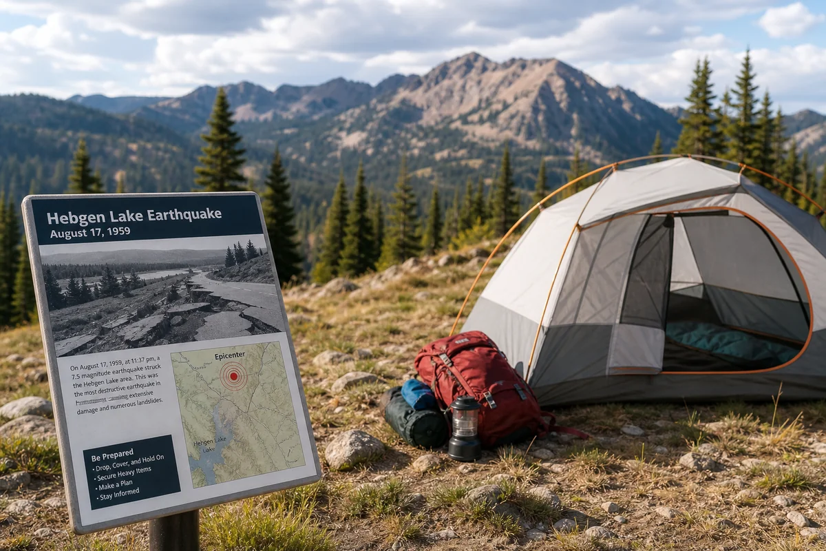
I was camping near Hebgen Lake last August when the ground beneath my tent started to vibrate—a subtle rumbling that lasted maybe three seconds before fading into the mountain silence.
My heart raced as I grabbed my phone to check the USGS website, confirming what I’d just experienced: a magnitude 3.2 earthquake centered just miles from where the deadliest earthquake in Montana history struck in 1959. That moment fundamentally changed how I think about the landscapes we explore in Big Sky Country.
Most visitors don’t realize that Montana sits atop one of the most seismically active regions in the Rocky Mountain West. Understanding this aspect of Montana History isn’t just fascinating—it’s practical knowledge that can enhance your travels and keep you prepared for the unexpected.
- Montana experiences 1,000+ earthquakes annually, mostly small and unfelt
- The 1959 Hebgen Lake earthquake killed 28 people and created Earthquake Lake—a must-visit site today
- The Intermountain Seismic Belt runs through western Montana, making it the most earthquake-prone region
- Yellowstone’s geothermal activity contributes to seismic swarms felt across southern Montana
- Visitors should know basic earthquake safety and understand evacuation routes near fault zones
- Historical earthquake sites offer unique educational tourism opportunities
Liked this article?
Add Roaming Montana as a preferred source so you see more of our articles and guides on Google.
Why Montana Has More Earthquakes Than You’d Expect
When people think of earthquake country, they picture California or Alaska—not the rugged mountains of Montana. But here’s the reality that surprised me during my research: Montana ranks among the top five most seismically active states in the Lower 48.
The culprit is the Intermountain Seismic Belt, a zone of frequent earthquake activity that stretches from southern Arizona through Utah, Idaho, and directly into western Montana. I’ve traced this belt on maps countless times while planning trips, and it essentially follows the same corridor where many of Montana’s most spectacular landscapes formed.
During my conversations with geologists at the Montana Bureau of Mines and Geology in Butte, I learned that the state experiences between 1,000 and 2,000 earthquakes every year. The vast majority are too small to feel—micro-tremors that only sensitive instruments detect.
But every few years, something bigger happens. When I reviewed the seismic records during a visit to their facilities, the pattern became clear: western Montana, particularly the area between Missoula and West Yellowstone, sees the most significant activity.
The 1959 Hebgen Lake Earthquake: A Tragedy That Shaped Montana
No discussion of Montana earthquakes can begin anywhere except August 17, 1959. I’ve visited Hebgen Lake and the Earthquake Lake Visitor Center multiple times over the years, and each visit reveals something new about this catastrophic event.
At 11:37 PM, a magnitude 7.3 earthquake struck with virtually no warning. The epicenter was located just north of Hebgen Lake, about 18 miles from West Yellowstone. I’ve stood at that exact spot, trying to imagine the terror of that night.
The statistics are staggering. Within seconds, an 80-million-ton landslide roared down from a mountain the locals called Sheep Mountain—now called Earthquake Lake Mountain. The debris traveled at over 100 miles per hour, burying the Rock Creek Campground beneath 200 feet of rock and debris.
Twenty-eight people died that night. Nineteen of them remain entombed beneath the landslide debris to this day. When I walked the memorial trail last summer, reading the names on the monuments, the weight of that history hit me in a way that reading about it never could.
The landslide dammed the Madison River, creating a new body of water that we now call Earthquake Lake or Quake Lake. It’s approximately six miles long and 190 feet deep at its maximum—a lake that didn’t exist before that August night.
Visiting the Earthquake Lake Visitor Center
The Earthquake Lake Visitor Center, operated by the U.S. Forest Service, is genuinely one of the most powerful educational experiences I’ve had anywhere in Montana. I recommend setting aside at least two hours here.
The center sits high above the lake on a bluff that offers panoramic views of the landslide scar. On my last visit in late July, a ranger named Sarah walked our group through a detailed timeline of the disaster, pointing out exactly where the campground had been before the mountain came down.
Inside the visitor center, you’ll find seismographs, relief models of the fault lines, and first-person accounts from survivors. The documentary film showing footage from the immediate aftermath is haunting—grainy black-and-white images of massive fault scarps, displaced roads, and rescue crews searching for survivors.
Admission is free, though donations are appreciated. The center is typically open from late May through late September, daily from 10 AM to 6 PM. However, I always recommend calling ahead at (406) 682-7620 since these hours can shift.
The Ghost Village of Cabin Creek
One of the lesser-known aspects of the 1959 earthquake—something I only learned about from local historians near Ennis—is the fate of small communities around Hebgen Lake.
The Cabin Creek area, once dotted with summer cabins and small lodges, was essentially abandoned after the earthquake. During a drive along Highway 287 last fall, I pulled over at several spots where you can still see evidence of the catastrophe: tilted trees that survived the initial quake but grew at strange angles, old foundations now far from the shoreline due to the lake’s dramatic water level changes.
The earthquake also severely damaged Yellowstone National Park, which sits just over the Montana border in Wyoming. Roads cracked, geysers changed their eruption patterns, and several hot springs suddenly appeared while others went dormant. This connection makes visiting both locations within the same trip incredibly rewarding for anyone interested in understanding these geological forces.
The Intermountain Seismic Belt: Montana’s Earthquake Engine
To truly understand Montana’s earthquake risk, you need to grasp what’s happening beneath your feet when you’re traveling through western Montana.
The Intermountain Seismic Belt isn’t a single fault line like California’s San Andreas. Instead, it’s a broad zone of crustal extension—the Earth’s crust is literally being pulled apart here, creating countless small faults and fracture zones.
I’ve hiked along several exposed fault scarps in the Centennial Valley south of Dillon. These steep escarpments, where one block of earth dropped relative to another during past earthquakes, are visible evidence of the ongoing geological forces at work.
The most active areas in Montana include:
- The Helena area – Experiences regular small earthquakes due to multiple intersecting fault systems
- The Upper Madison Valley – Where the 1959 earthquake occurred and seismic activity continues today
- The Flathead Lake region – Sits above the Mission Fault, which shows evidence of large prehistoric earthquakes
- The Bitterroot Valley – The dramatic Bitterroot Front represents ancient fault movement, with ongoing minor activity
During a geology tour I took near Missoula, our guide showed us how to identify fault scarps in the landscape. Once you know what to look for—those distinctive linear breaks in the topography—you start seeing them everywhere in western Montana.
Yellowstone’s Influence on Montana Seismicity
You can’t discuss Montana earthquakes without talking about the volcanic elephant in the room: the Yellowstone supervolcano.
While Yellowstone’s caldera is technically in Wyoming, its seismic influence extends well into Montana. I’ve felt two different earthquake swarms while staying in West Yellowstone—both times, the shaking was gentle enough that I initially thought a large truck was passing by before realizing what was actually happening.
Yellowstone experiences between 1,000 and 3,000 earthquakes annually, most of them too small to feel. These quakes are primarily caused by the movement of hydrothermal fluids beneath the surface and the ongoing volcanic processes that power Old Faithful and the park’s other geothermal features.
In 2017 and 2018, major earthquake swarms near West Yellowstone rattled residents and visitors alike. The 2017 swarm included over 2,400 individual earthquakes over several months, with the largest reaching magnitude 4.4.
During conversations with rangers at the Yellowstone Volcano Observatory information desk, I learned that these swarms, while dramatic, are normal behavior for the Yellowstone system. The concerning scenario would be a sudden change in the pattern—something scientists monitor constantly.
What a Yellowstone Eruption Would Mean for Montana
Let me be clear: a major Yellowstone eruption is not something to lose sleep over when planning your Montana vacation. The probability of a catastrophic eruption in any given year is approximately 1 in 730,000.
However, understanding the scenario is part of appreciating Montana’s geological story. If a supervolcanic eruption did occur, the immediate area within about 40 miles of the caldera would face pyroclastic flows. Cities like West Yellowstone and parts of southwest Montana would be directly threatened.
The broader Montana impact would come from ashfall. Models suggest that even Missoula and Helena could receive several inches of volcanic ash, while Billings and eastern Montana might see lighter but still significant deposits.
Again, this is a worst-case scenario with an infinitesimal probability. I mention it only because visitors often ask, and understanding the full geological picture helps appreciate why Montana’s landscape looks the way it does.
Historical Earthquakes Beyond 1959
While the Hebgen Lake earthquake dominates Montana’s seismic history, it wasn’t the first significant earthquake in the state, nor has it been the last.
The 1925 Manhattan Earthquake
On June 27, 1925, a magnitude 6.6 earthquake struck near Manhattan and Three Forks in the Gallatin Valley. This event caused significant damage to buildings in the small farming communities of the region.
During a visit to the Montana Historical Society in Helena, I found fascinating newspaper accounts from the aftermath. The earthquake cracked foundations, toppled chimneys, and terrified residents who had little experience with such events.
What makes the 1925 earthquake particularly interesting is its location—it struck in an area that’s now much more developed. The same earthquake today would cause substantially more damage and economic disruption.
Recent Significant Events
Montana continues to experience notable earthquakes. Here’s a summary of significant recent events:
| Year | Location | Magnitude | Impact |
|---|---|---|---|
| 2017 | Lincoln | 5.8 | Felt across western Montana; minor building damage |
| 2020 | Challis, ID/MT border | 6.5 | Strongly felt in Missoula; no major damage in Montana |
| 2023 | Near Helena | 4.2 | Widely felt; no significant damage |
The 2017 Lincoln earthquake was particularly memorable for me because I was visiting friends in Helena that summer. The shaking was strong enough to knock items off shelves and rattle windows across the region. Phone alerts lit up immediately, and social media exploded with “Did you feel that?” posts.
Earthquake Preparedness for Montana Travelers
Now let’s get practical. If you’re planning a trip to Montana—especially to the western region or Yellowstone area—here’s what you actually need to know about earthquake preparedness.
What to Do If an Earthquake Strikes
The advice has evolved over the years. The old “stand in a doorway” guidance is outdated. Here’s what experts now recommend:
If you’re indoors: Drop, cover, and hold on. Get under a sturdy desk or table if available. If not, move to an interior wall away from windows and cover your head with your arms. Stay put until the shaking stops.
If you’re outdoors: Move away from buildings, power lines, and trees. Drop to the ground and protect your head. If you’re in a mountainous area, be aware that rockfall and landslides often accompany earthquakes.
If you’re driving: Pull over to the side of the road away from overpasses, bridges, and power lines. Stay in your vehicle until the shaking stops.
If you’re camping: Get out of your tent if possible and move to an open area away from trees and steep slopes. The 1959 earthquake killed campers partly because of falling trees and the resulting landslide.
Specific Considerations for Popular Destinations
When camping near Hebgen Lake or Earthquake Lake, I always choose sites away from steep hillsides. The psychological comfort alone is worth the extra planning.
In Yellowstone, be aware that earthquake activity can affect geothermal features. After significant earthquakes, some boardwalks may be temporarily closed while rangers assess thermal area stability.
If you’re staying in historic buildings—Montana has beautiful old hotels and lodges—take a moment to identify exits and stable areas. Many older structures weren’t built with seismic considerations in mind.
Geological Tourism: Exploring Montana’s Seismic Landscape
Montana’s earthquake history has created some genuinely unique tourism opportunities. Over the years, I’ve developed what I call my “seismic Montana” itinerary—a route that takes visitors through the most geologically fascinating areas.
The Hebgen Lake Loop
Start in West Yellowstone and drive north on Highway 287. The Earthquake Lake Visitor Center is your first major stop. After exploring the exhibits, continue driving north along the lake.
Stop at the Ghost Village site, where interpretive signs explain the former community that was abandoned after the earthquake. The haunting dead trees standing in the lake—killed when the water level rose after the dam formed—create some of Montana’s most eerie photography opportunities.
Continue to the Cabin Creek Scarp area, where you can see one of the largest fault scarps created by the 1959 earthquake. The earth dropped about 20 feet on one side of the fault here—a dramatic visual reminder of the forces involved.
The Helena-Lincoln Seismic Zone
The area around Helena and Lincoln experiences frequent small earthquakes. While there’s no dedicated visitor center here, the drive through this region offers opportunities to see fault-controlled landscapes.
The canyon of the Blackfoot River east of Lincoln follows a fault zone, and the dramatic valley walls are partly a result of seismic activity over millions of years. I’ve kayaked this stretch of river multiple times, always with a new appreciation for how geology shaped the corridor.
The Lewis and Clark Library in Helena has an excellent Montana room with historical earthquake records and photographs from past seismic events. It’s worth an hour of browsing if you’re in the capital city.
The Mission Fault and Flathead Lake
The dramatic mountain front east of Flathead Lake represents one of Montana’s most impressive fault scarps. The Mission Range rises abruptly from the valley floor along the Mission Fault—evidence of millions of years of earthquake activity.
Geological studies have found evidence of magnitude 7+ earthquakes along this fault within the past several thousand years. While such an event is unlikely in any human lifetime, it reminds us that the forces shaping this landscape are still active.
The Flathead Lake Biological Station near Yellow Bay sometimes offers public lectures on regional geology. When I attended one during a summer visit, the presentation included fascinating details about sediment records that reveal the timing of past earthquakes.
How Earthquakes Have Shaped Montana’s Culture and Development
Living with seismic risk has influenced Montana in ways that visitors might not immediately notice. The state’s building codes, while not as stringent as California’s, do include seismic considerations for new construction.
The 1959 earthquake also prompted the creation of improved early warning systems and better coordination between federal, state, and local emergency services. Much of Montana’s modern emergency management infrastructure traces its origins to lessons learned from that tragedy.
I’ve noticed that longtime Montana residents talk about earthquakes with a matter-of-fact acceptance that contrasts sharply with visitors’ surprise. “Oh, we had a little one last week,” a rancher near Ennis told me during a recent visit, as casually as he might mention the weather.
This cultural relationship with seismic activity connects to broader themes in key historical events in Montana that have shaped the state’s character. Just as the harsh Montana winter of 1886 transformed the cattle industry, major earthquakes have influenced how Montanans think about their relationship with the land.
The state’s history of adapting to natural challenges—whether devastating wildfires, brutal winters, or seismic events—has fostered a resilient population that approaches each new challenge pragmatically.
The Science Behind Montana Earthquakes Today
Modern seismic monitoring in Montana involves a network of sensitive instruments operated by the Montana Bureau of Mines and Geology, the USGS, and the University of Montana.
During a tour of the seismic monitoring facilities in Butte, I was fascinated to learn how much the science has advanced since 1959. Today’s instruments can detect earthquakes as small as magnitude 0.5—far too subtle for humans to feel but important for understanding fault behavior.
The data gathered helps scientists create seismic hazard maps that inform building codes, emergency planning, and public education. You can view real-time seismic data for Montana on the USGS website, which I often check before and during trips to the western part of the state.
Researchers are also studying the relationship between human activity and seismicity. While Montana doesn’t face the “induced seismicity” issues seen in Oklahoma (where wastewater injection has caused earthquakes), scientists continue monitoring for any connections between resource extraction and seismic activity.
Planning Your Trip: Practical Information
Here’s the bottom line for travelers: Montana’s earthquake risk should inform your planning but not discourage your visit. The odds of experiencing a significant earthquake during any given trip are extremely low.
Best Times to Visit Earthquake-Related Sites
The Earthquake Lake Visitor Center is best visited between June and early September when staffing is fullest and all programs are running. The Memorial Day weekend opening can be weather-dependent in some years.
Summer offers the best conditions for hiking fault scarps and exploring the backcountry, but fall brings fewer crowds and stunning colors around Hebgen Lake. I particularly love late September visits when the aspen trees turn gold against the dramatic mountain scarps.
What to Pack
Beyond standard Montana travel gear, consider:
- A small flashlight or headlamp (useful if an earthquake strikes at night)
- Basic first aid supplies
- Physical maps (cell service is unreliable in many seismically active areas)
- Emergency contact information for your lodging
Resources for Real-Time Information
Bookmark these resources before your trip:
- USGS Latest Earthquakes Map (earthquake.usgs.gov)
- Montana Bureau of Mines and Geology
- Yellowstone Volcano Observatory
- National Park Service Yellowstone Alerts
I check these sites routinely during Montana trips, especially when staying in the Yellowstone area. The information helps me understand what’s happening beneath the landscape I’m exploring.
Connecting Earthquakes to the Broader Montana Story
Understanding Montana’s seismic history enriches appreciation for everything else the state offers. The same geological forces that cause earthquakes also created the hot springs that drew early tourists, the mineral deposits that sparked the Montana gold rush, and the dramatic mountain landscapes that define the state’s identity.
The legacy of pioneers who settled Montana included facing natural challenges that modern visitors rarely consider. Those early homesteaders built without seismic codes, their log cabins and stone foundations often cracking during earthquakes that went unrecorded by scientific instruments.
Even the state’s culinary heritage connects to geology—the volcanic soils in some Montana valleys produce distinctive crops, while geothermal features have been used for everything from heating greenhouses to pasteurizing milk.
The Cold War era saw Montana’s geological stability evaluated for different reasons. When the federal government chose Montana for missile silos and launch sites, seismic risk was one factor in site selection. The state’s role hosting active military bases and once housing secret military installations meant that earthquake preparedness extended to protecting national security infrastructure.
Even Montana’s prisons had to account for seismic risk—the old Deer Lodge facility predates modern building codes, while newer correctional facilities incorporate seismic design elements.
Final Thoughts from the Field
Standing at the Earthquake Lake overlook during my most recent visit, I watched the late afternoon light play across the landslide scar on the mountain. The wound in the earth has softened over six decades—grasses and small trees have begun reclaiming the debris field—but the scale of what happened here remains sobering.
Montana’s earthquakes remind us that the landscape we love is actively being created. The mountains aren’t static backdrops; they’re growing, shifting, and occasionally shaking. That knowledge adds a layer of meaning to every mountain view, every river valley, every hot spring visit.
When you’re exploring Montana, you’re not just traveling through beautiful scenery. You’re witnessing geological processes that have been reshaping this land for millions of years and will continue long after we’re gone.
Just as understanding where Montana’s name comes from or what the 406 area code means enriches your connection to the state, knowing about its seismic history deepens your appreciation for every landscape you encounter.
The underwater history preserved in Montana’s ancient lake beds, the darker chapters of human history that unfolded against this dramatic backdrop—every story is connected to the geological stage on which Montana’s drama plays out.
So yes, Montana has earthquakes. It’s had devastating ones in the past and will have them again in the future. But understanding that risk—and visiting the places where that geological power has left its mark—makes for a richer, more meaningful Montana experience.
I’ll be back at Earthquake Lake next summer, probably camping somewhere away from the steep hillsides, watching the stars wheel overhead and feeling grateful for the dynamic, dramatic, occasionally trembling ground beneath me.
Frequently Asked Questions
Has Montana ever had a major earthquake that affected travelers?
Yes, Montana experienced one of the largest earthquakes in U.S. history on August 17, 1959, when a 7.5 magnitude quake struck near Yellowstone, killing 28 people and creating Quake Lake. I’d highly recommend visiting the Earthquake Lake Visitor Center near West Yellowstone to learn about this dramatic event—it’s a fascinating and sobering stop that takes about 1-2 hours.
Is it safe to travel to Montana with ongoing earthquake activity?
Montana is generally very safe for travelers despite being one of the more seismically active states, with most earthquakes being too small to feel. The state averages 7-10 minor earthquakes per week, but significant ones are rare. I wouldn’t let earthquake concerns change your travel plans, though it’s smart to know basic earthquake safety just as you would in California.
Where can I see earthquake damage and geology sites in Montana?
The Earthquake Lake Visitor Center, located about 27 miles northwest of West Yellowstone on Highway 287, showcases the 1959 Madison Canyon earthquake with exhibits, a memorial boulder garden, and views of the massive landslide. You can also see Quake Lake itself, ghost trees still standing in the water, and the fault scarp along Hebgen Lake—all free to view from the roadside.
What is the best time to visit Montana’s earthquake historical sites?
The ideal time to visit is late May through September when the Earthquake Lake Visitor Center is fully open and roads are clear of snow. I visited in early June and had smaller crowds plus comfortable 60-70°F weather perfect for exploring outdoor geological features. The visitor center typically charges around $5-8 per adult for entry.
How far is the 1959 earthquake site from Yellowstone National Park?
The Earthquake Lake Visitor Center is just 27 miles from West Yellowstone’s park entrance, making it an easy 45-minute side trip that pairs perfectly with a Yellowstone itinerary. From Bozeman, it’s approximately 90 miles or about 1.5 hours driving through scenic canyon roads. I’d suggest combining it with a morning in the park’s geyser basins.
What should I bring when visiting Montana earthquake sites?
Pack layers since mountain elevations mean cooler temperatures even in summer, plus sturdy walking shoes for the interpretive trails around Quake Lake. Binoculars are useful for spotting the landslide scars and ghost forest across the lake, and don’t forget your camera—the geological features are incredibly photogenic. Cell service is spotty, so download maps beforehand.
Are there earthquake preparedness tips for camping in Montana?
When camping near Yellowstone or in western Montana’s seismic zones, avoid setting up directly under dead trees or unstable rock formations, and keep shoes and a flashlight near your sleeping bag. Most campgrounds in the area, including those near Hebgen Lake, are well-established and safe. I always check the USGS earthquake map before my trips just to stay informed about recent activity.
Sources
- https://www.montana.edu/emergency/emergency_actions/earthquake.html
- https://www.usgs.gov/news/60-years-1959-m73-hebgen-lake-earthquake-its-history-and-effects-yellowstone-region
- https://www.fs.usda.gov/detail/custergallatin/home/?cid=FSEPRD891034
- https://www.usgs.gov/news/featured-story/magnitude-58-earthquake-montana
- https://serc.carleton.edu/files/earthscoperockies/stickneyposter_1129844125.pdf
- https://picryl.com/media/helena-montana-demolition-of-buildings-damaged-in-1935-earthquakes
- https://commons.wikimedia.org/wiki/File:Hebgen_Lake_House
- https://commons.wikimedia.org/wiki/File:Dillon,_Montana
- https://commons.wikimedia.org/wiki/File:Lincoln,_Montana