The first time I drove from Choteau to Augusta along the eastern edge of the Rocky Mountain Front, I had to stop the car three times in 25 miles — once for the light, once for a pronghorn herd crossing the highway, and once because the Front itself simply demanded that I stop and look.
The Rockies don’t ease into the plains here. They slam into them. The grass goes flat to the horizon in one direction and vertical to 9,000 feet in the other, with nothing in between. The first naturalist to see it called it “the place where the mountains stop.” That’s still the best description I’ve heard.
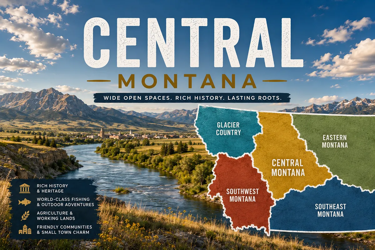
Central Montana is the region most travelers blow right past — and the one most likely to make a real impression if you slow down.
TL;DR
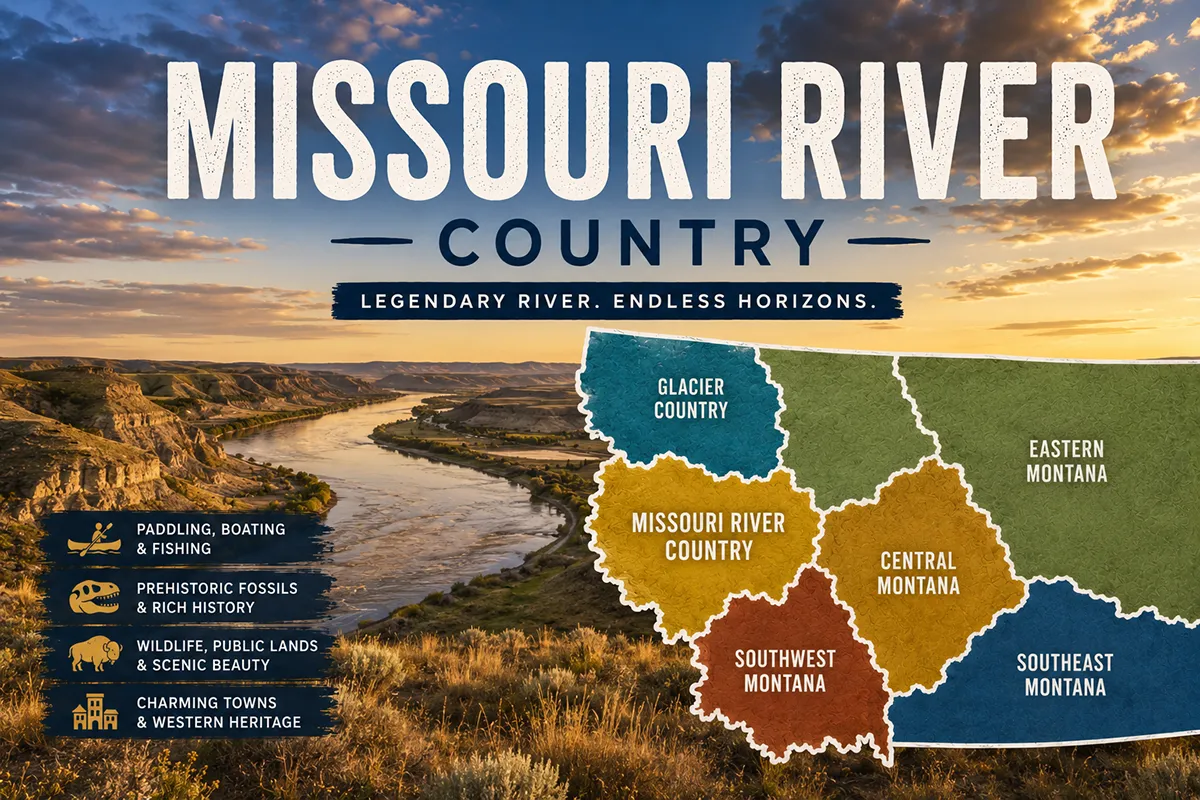
Central Montana is the largest of Montana’s six tourism regions by land area and one of the least visited. It covers everything from Great Falls (the third-largest city in the state) north to the Canadian border, east through the Missouri Breaks badlands, and south into the Little Belt Mountains. The region’s signature features are the Rocky Mountain Front, the Hi-Line (US-2 corridor), the Lewis & Clark trail, Smith River floats, the Dinosaur Trail, and an honest small-town Montana experience that the more famous regions have largely lost. Best time to visit: May through September, with the wheat harvest in late August as a sleeper-favorite window. If you’re on your second or third Montana trip — or you came to escape the Glacier and Yellowstone crowds — this is where you go.
What Is Central Montana?
Central Montana is one of Montana’s six official tourism regions, established by the Montana Legislature in 1986–87 along with the state lodging tax.
The marketing organization for the region brands it as “Central Montana / Russell Country” in honor of cowboy artist Charles M. Russell, who lived and worked here for most of his career.
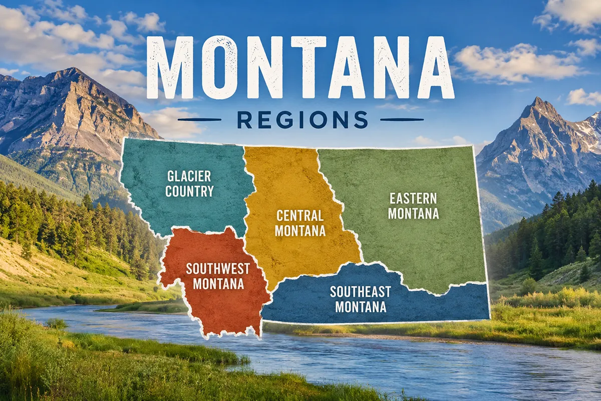
Geographically, Central Montana is the largest tourism region in the state by area. It covers roughly 16 counties: Cascade, Chouteau, Teton, Pondera, Toole, Liberty, Hill, Blaine, Phillips, Fergus, Petroleum, Judith Basin, Wheatland, Golden Valley, Musselshell, and Meagher. That’s a stretch of country bigger than several U.S. states combined.
The region runs from the Canadian border in the north (Sunburst, Sweet Grass) down through Great Falls and the Missouri River corridor, east into the Missouri Breaks badlands, and south into the Little Belt, Big Snowy, Highwood, and Castle Mountains — the famous “island mountain ranges” that rise out of the plains like ships at sea.
Its western boundary is the Rocky Mountain Front — the eastern slope of the Rockies, which forms one of the most dramatic landscape transitions in North America. Its eastern boundary blurs into Missouri River Country around the Missouri Breaks National Monument.
One naming note: a lot of older travel guides call this “the in-between Montana” because it sits between Glacier Country (NW) and Yellowstone Country (S).
That phrase is accurate but a little dismissive. Central Montana isn’t in-between — it’s the rest of the state, the part that hasn’t been remade for tourism.
The Towns of Central Montana
Where you base shapes the trip entirely. Here’s the honest breakdown.
Great Falls
The Electric City. Great Falls is the third-largest city in Montana (around 60,000 residents) and the cultural and commercial hub of Central Montana.
It sits on the Missouri River at a series of five waterfalls that gave the city its name and its nickname — the falls power five hydroelectric dams, which is why locals call it the Electric City.
Two world-class museums make Great Falls a must-visit even if you don’t base here: the C.M. Russell Museum (the most important collection of Charles M. Russell’s cowboy art anywhere) and the Lewis & Clark Interpretive Center overlooking the Missouri.
Both are easily a full day each. Giant Springs State Park sits right on the edge of town — one of the largest freshwater springs in the U.S., pumping 156 million gallons of water per day at a constant 54°F.
Base in Great Falls if: You’re flying into GTF, you want a real city base with food and breweries, museums are a priority, you’re combining a trip with the Front or the Missouri River.
➡️ Best coffee shops in Great Falls | Electric City Water Park | Great Falls RV parks
Lewistown
The geographic center of Montana, almost literally. Lewistown is a former gold-and-cattle town in the Judith Basin, surrounded by three island mountain ranges (the Big Snowies, the Judiths, the Moccasins).
Population around 6,000. The downtown has beautifully restored stone buildings — many built from local Madison limestone — and a genuinely warm small-town feel.
The town is the unofficial capital of central Montana’s agricultural heartland. Big Spring Creek runs through Lewistown and is one of the most consistent trout streams in the state.
The Big Snowy Mountains to the south have ice caves and hiking. Charlie Russell Chew Choo dinner train runs scenic excursions through the Judith Valley.
Base in Lewistown if: You want the most centrally located base in the region, you’re interested in agricultural Montana, you want the Big Snowy Mountains, fly fishing in Big Spring Creek is on your list.
Havre
The Hi-Line hub. Havre (pronounced “HAV-er,” not “AHV-ruh”) is the largest town on the Hi-Line — the BNSF Railway and US-2 corridor running across the top of Montana.
About 9,000 residents, home to Montana State University–Northern, and a real working town that exists because of the railroad.
The most underrated attraction here is Havre Beneath the Streets — a guided tour of the underground city that Havre built when its downtown burned in 1904.
Merchants and businesses (including, infamously, the bordellos and opium dens) operated underground while the surface was being rebuilt. The tour preserves the original spaces.
Wahkpa Chu’gn Buffalo Jump just outside Havre is one of the most significant archaeological sites in North America. About 2,000 years of layered bison kill remains, sometimes 18 feet deep.
Base in Havre if: You want a true Hi-Line experience, you’re interested in railroad history or Native American archaeology, you’re heading toward Bear Paw Battlefield.
Fort Benton
The “Birthplace of Montana.” Fort Benton was established in 1846 as a fur-trading post on the upper Missouri River, decades before the Montana Territory existed.
From the 1860s through the 1880s, it was the head of navigation on the Missouri — every steamboat carrying supplies to the Montana gold camps stopped here. At its peak, Fort Benton was the inland-most port in the world.
Today, the waterfront is a National Historic Landmark. The Museum of the Upper Missouri, the Museum of the Northern Great Plains (one of the best agricultural history museums anywhere), and the Old Fort Park are all walkable. The Grand Union Hotel (1882) is the oldest operating hotel in Montana.
Base in Fort Benton if: History interests you, you’re floating the Missouri River, you want a tiny historic-town base with surprisingly good food.
Choteau
The gateway to the Rocky Mountain Front. Choteau (pronounced “SHOW-toe”) is a small ranching town at the eastern foot of the Front.
The Old Trail Museum is a small but excellent dinosaur and pioneer museum — Choteau sits in fossil-rich country, and the discoveries here include Egg Mountain, where paleontologist Jack Horner found the first dinosaur nests in North America, fundamentally changing how we understand dinosaur parenting.
The Pine Butte Swamp Preserve outside Choteau is a Nature Conservancy site that protects the easternmost grizzly bear range in the U.S.
Base in Choteau if: The Rocky Mountain Front is your priority, you’re interested in dinosaurs, you want to be close to the Bob Marshall Wilderness eastern boundary.
White Sulphur Springs
A small spa town in the Smith River country. White Sulphur Springs is named for its natural mineral hot springs (still accessible at the Spa Hot Springs Motel — open to non-guests).
The Castle Museum — an 1892 stone mansion built by a wealthy mine owner — is the centerpiece of town. The annual Red Ants Pants Music Festival every July has become one of Montana’s most beloved small-town festivals.
This is also the put-in point for the Smith River float (see below).
Base in White Sulphur Springs if: Smith River is on your list, hot springs are a priority, you want a tiny town with character.
Other Towns Worth Knowing
- Augusta — the western-most town in the region, hard up against the Front, gateway to Sun River Canyon
- Fairfield — the “Malting Barley Capital of the World,” real wheat country
- Dutton, Bynum — small farming towns along US-89
- Cascade and Belt — between Great Falls and the Little Belts; Belt’s old brewery and main street are worth a stop
- Cut Bank — the “coldest spot in the nation” claim (their giant penguin statue says so); gateway to the Blackfeet Reservation
- Shelby — US-15/US-2 crossroads, infamous for hosting a 1923 Jack Dempsey heavyweight boxing match that bankrupted the town
- Conrad and Chester — small Hi-Line agricultural towns
- Big Sandy — Hi-Line town, home of the Big Sandy Bear and a surprisingly good museum
- Chinook — base for visiting Bear Paw Battlefield
- Harlem — gateway to the Fort Belknap Reservation
- Sunburst — closest Montana town to the Canadian border
- Denton, Winifred, Roy, Winnett — gateways to the Missouri Breaks
- Martinsdale — home of the surprising and excellent Charles M. Bair Family Museum
- Ryegate — site of the annual Testicle Festival every June (genuinely; it’s a real thing; rocky mountain oysters)
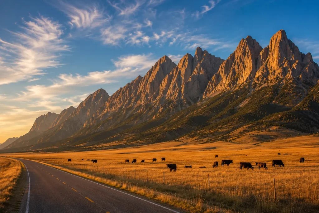
The Rocky Mountain Front
This is the headline geography of Central Montana. The Rocky Mountain Front is the eastern face of the Rockies — a 100-mile band of mountains that rises straight out of the plains between roughly Wolf Creek in the south and Browning in the north. There is no foothill transition. The plains end. The mountains start.
The Nature Conservancy calls it “the only place in the lower 48 where grizzly bears still roam onto the prairie.” That’s not marketing copy — it’s geographically and ecologically true.
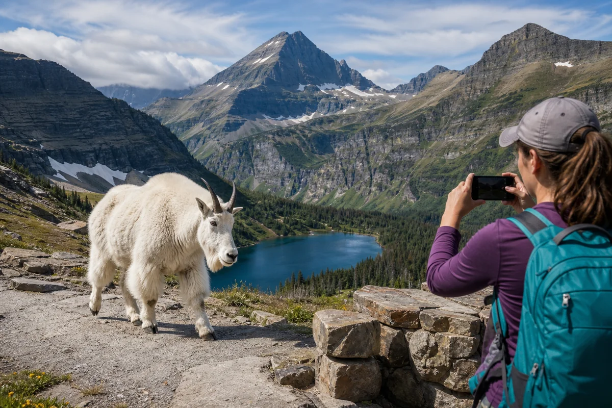
The Front supports grizzlies, wolves, elk, bighorn sheep, mountain goats, lynx, and the largest wintering elk herd in North America (the Sun River Game Range).
Best ways to experience the Front:
- Drive US-89 between Choteau and Browning at sunrise or sunset
- Hike in the Sun River Game Range west of Augusta
- Visit Pine Butte Swamp Preserve near Choteau
- The Teton Pass Ski Area (small, family-run) offers a unique elevated view in winter
The Bob Marshall Wilderness Complex — at 1.5 million acres, one of the largest contiguous wilderness areas in the lower 48 — sits directly west of the Front. The Bob has no roads, no motorized vehicles, no bicycles.
The “Bob” is famous for its Chinese Wall — a 1,000-foot sheer escarpment running for 22 miles. To see it you need to backpack at least 17 miles in.
The Smith River: One of the Most Famous Floats in the World
The Smith River runs about 60 miles between Camp Baker (south of White Sulphur Springs) and Eden Bridge (near Great Falls).
The river cuts through a 1,000-foot limestone canyon, has world-class trout fishing, hundreds of small caves, and is accessible only by boat — there are no roads in or out for most of its length.
The catch: Floats are permit-restricted by lottery. Roughly 15 launches per day are allowed, and applications open in January each year for the upcoming season. Drawings happen in February.
Success rates run around 5–10% in peak weeks. If you can get a permit (or know someone with a guide service quota), this is one of the most extraordinary multi-day floats in the U.S.
If you don’t draw a permit, the Holter Dam to Craig stretch of the Missouri River (technically just inside Southwest Montana but accessible from Great Falls) is a world-class day-float fishery with no permit required.
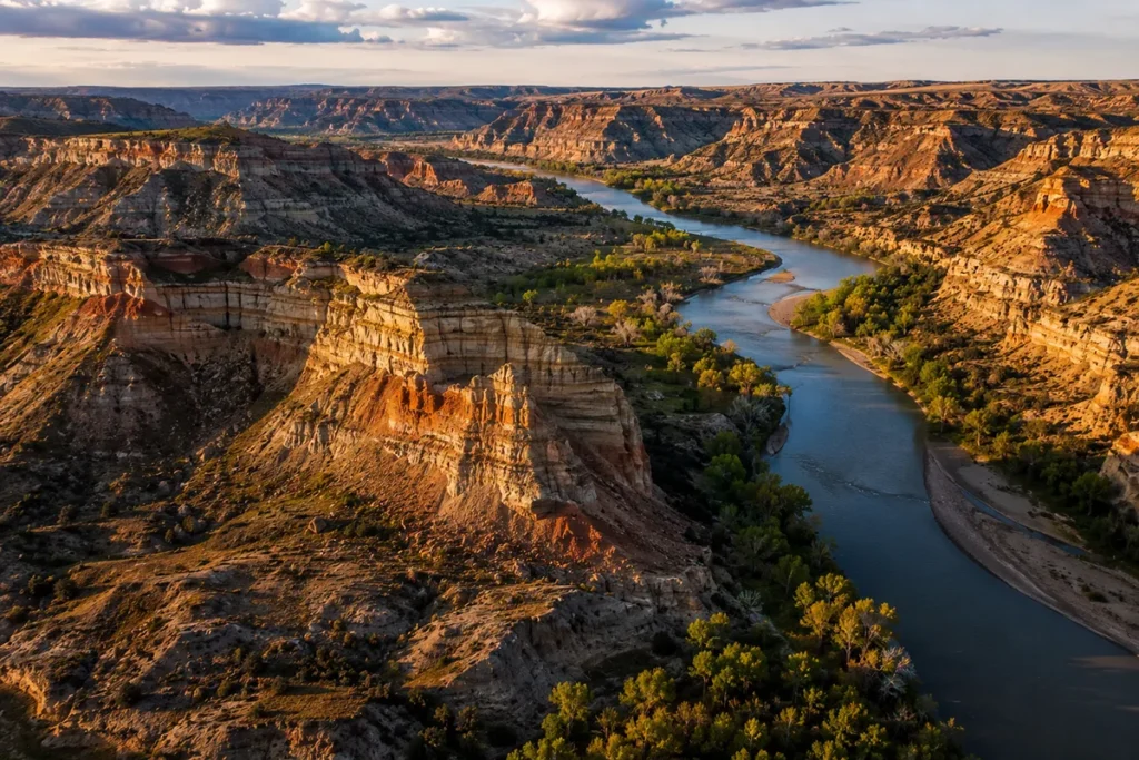
The Missouri Breaks
Where the Missouri River cuts a winding badlands canyon between Fort Benton and Fort Peck Lake. This is the stretch where Lewis & Clark spent more time than any other during their 1804–06 expedition, and it has changed less than almost anywhere else they passed through.
The Upper Missouri River Breaks National Monument protects 375,000 acres and 149 miles of Wild and Scenic Missouri River.
The most popular access is the multi-day float from Fort Benton to Kipp (~149 miles, 5–8 days, no permit required for non-commercial floats). You camp on sandbars under skies that have looked exactly the same since 1805.
The Breaks are also the heart of Hell Creek dinosaur country — some of the most important paleontological discoveries in history have come from these badlands.
The Dinosaur Trail
Montana has one of the richest dinosaur fossil records on Earth, and most of the major sites are in Central Montana. The Montana Dinosaur Trail strings together 14 museums and field sites across the state — about half of them in Central Montana:
- Great Plains Dinosaur Museum — Malta (technically Missouri River Country, but on the trail)
- Two Medicine Dinosaur Center — Bynum (one of the best small dinosaur museums anywhere)
- Old Trail Museum — Choteau (Egg Mountain)
- Phillips County Museum — Malta
- Upper Musselshell Museum — Harlowton (technically Southwest)
- H. Earl Clack Museum — Havre
- Carter County Museum — Ekalaka (Southeast)
- C.M. Russell Museum’s Browning Wing — Browning
If your kids are dinosaur-obsessed, this is the trip. Most museums let you watch active fossil preparation through windows.
Bear Paw Battlefield: The End of the Nez Perce War
About 16 miles south of Chinook sits a small, somber, perfectly preserved field where the Nez Perce War ended on October 5, 1877.
After a flight of 1,170 miles from Oregon, Chief Joseph and the remaining Nez Perce surrendered to General Nelson Miles, just 40 miles from the Canadian border and freedom.
It is the site of Chief Joseph’s famous “I will fight no more forever” speech. The battlefield itself is mostly unchanged from 1877 — there is no developed visitor center, just a small parking lot, interpretive signs, and a 1.25-mile loop trail. The wind, the grass, the wide sky.
It is one of the most affecting places I have ever stood. If you have any interest in Native American history, build it into your trip.
Things to Do in Central Montana
A quick highlight reel:
- Drive the Front — US-89 between Choteau and Browning, ideally at sunrise
- C.M. Russell Museum — Great Falls, the most important collection of Russell’s art
- Lewis & Clark Interpretive Center — Great Falls, one of the best of the entire Lewis & Clark trail
- Giant Springs State Park — Great Falls
- First Peoples Buffalo Jump State Park — outside Great Falls, the largest known bison jump in North America
- Smith River float — White Sulphur Springs put-in, permit lottery
- Missouri Breaks float — Fort Benton to Kipp, no permit
- Bear Paw Battlefield — outside Chinook
- Sluice Boxes State Park — limestone canyon south of Belt
- Showdown Ski Area — small family-run hill in the Little Belt Mountains
- Big Snowy Mountains — hiking, ice caves, dispersed camping
- Egg Mountain — dinosaur nesting site near Choteau
- Square Butte — instantly recognizable flat-topped landmark east of Great Falls (it appears in dozens of Charles Russell paintings)
- Charles M. Bair Family Museum — Martinsdale, surprising and excellent
- Old Fort Park & the Steamboat Landing — Fort Benton
- Havre Beneath the Streets — Havre
Hot Springs in Central Montana
Far fewer than Southwest Montana, but a few worth knowing:
- Spa Hot Springs Motel — White Sulphur Springs, mineral pools open to non-guests
- Gigantic Warm Springs — Lewistown-area, smaller and undeveloped
- Sleeping Buffalo Hot Springs — Saco area, technically in Missouri River Country but accessible from the eastern edge of the region
➡️ Full picture: Montana hot springs guide
A 5-Day Central Montana Itinerary
What I’d recommend for a first visit:
- Day 1: Fly into Great Falls (GTF). C.M. Russell Museum afternoon. Walk Black Eagle Falls. Dinner downtown.
- Day 2: Lewis & Clark Interpretive Center, Giant Springs State Park, First Peoples Buffalo Jump. Drive to Choteau.
- Day 3: The Rocky Mountain Front day. US-89 north toward Browning. Pine Butte Preserve. Egg Mountain. Sunset at Augusta.
- Day 4: Drive across the Hi-Line. Stop in Fort Benton (Grand Union Hotel lunch). Continue to Havre. Havre Beneath the Streets.
- Day 5: Bear Paw Battlefield in the morning. Drive south to Lewistown via Big Sandy. Overnight in Lewistown or return to Great Falls.
For a longer trip, add a Smith River float (if you have a permit) or a Missouri Breaks float (no permit) — both add 3–5 days minimum.
Practical Info Box: Central Montana at a Glance
| Item | Details |
|---|---|
| Major airport | Great Falls International (GTF) |
| Best season overall | May through September |
| Best for harvest atmosphere | Late August |
| Counties included | 16, including Cascade, Chouteau, Teton, Pondera, Hill, Blaine, Fergus |
| Largest city | Great Falls (~60,000) |
| Major rivers | Missouri, Smith, Sun, Teton, Marias, Judith, Musselshell |
| Largest wilderness | Bob Marshall Wilderness Complex (1.5 million acres) |
| Bear country? | Yes, especially along the Front — carry bear spray |
| Cell service | Good in towns, patchy in the mountains, essentially gone in the Breaks |
| Time zone | Mountain Time (MST/MDT) |
| Major drive routes | US-89 (the Front), US-2 (the Hi-Line), US-87, I-15 |
➡️ See Montana airports overview for full options.
What I Wish I’d Known Before My First Trip
A few things that would have saved me real time and frustration.
Distances are deceiving. Lewistown to Havre looks short on a map. It’s a real two-hour drive through gorgeous nothing. Add 25% to your time estimates and gas up when you can.
Cell service is genuinely spotty. Especially north of Havre, throughout the Breaks, and along the Front. Download offline maps. Tell someone where you’re going.
The harvest changes everything. If you can visit in late August, the entire region turns gold and the energy on the back roads is something I genuinely look forward to every year. Combine harvesters at sunset, grain trucks with their lights on, county fairs.
Smith River permits are a January project. If a Smith River float is on your bucket list, you need to be on it the moment applications open. Most years, drawings happen in mid-February.
The Front is bear country. Grizzlies regularly come down onto the prairie east of the mountains here in a way they don’t anywhere else in the lower 48. Carry bear spray on every hike. Make noise.
Charlie Russell country is everywhere, not just in Great Falls. Russell painted scenes from across this region. Square Butte, Judith Basin, the Missouri Breaks — all show up in his paintings, often unchanged today.
Some museums close in winter. Most of the smaller dinosaur trail museums and several state parks close November through March. Always check before driving four hours.
Wheat dust is real in harvest season. I once underestimated this and ended up cleaning my car for three days. Worth it. But know.
This region’s lodging is the cheapest in Montana. Hotel rates in Havre, Lewistown, and Fort Benton in July run a fraction of what you’d pay in Bozeman or Whitefish. Some real value here.
Local cafes are your friends. The food scene isn’t fancy, but the diners along the Hi-Line are some of my favorite eating in Montana. Order whatever the chalkboard special is. Tip well.
Where to Stay (Quick Reference)
| Stay style | Best location |
|---|---|
| City hotel | Great Falls (largest selection) |
| Historic property | Fort Benton (Grand Union Hotel), Lewistown |
| Hot springs | White Sulphur Springs (Spa Hot Springs Motel) |
| Front-adjacent | Choteau, Augusta |
| Hi-Line authentic | Havre, Shelby, Chinook |
| Ranch experience | Throughout the Front, Sun River Valley |
| RV / camping | Multiple state parks; private RV parks in Great Falls |
How Central Compares to the Other Five Regions
| Factor | Central Montana | Glacier Country | Yellowstone Country | Southwest Montana |
|---|---|---|---|---|
| Major national park | None | Glacier | Yellowstone | None |
| Headline geography | Rocky Mountain Front | Glacier peaks | Yellowstone Plateau | Mining country + Pintlers |
| Crowds | Very low | Heavy | Heavy | Low |
| Best for | Second/third-trip Montana | First-timers | First-timers | Repeat visitors |
| Affordability | Cheapest | Most expensive | Expensive | Affordable |
| Best season | May–Sept (late Aug standout) | Mid-July–mid-Sept | May–Sept | June–Sept |
| Wildlife | Excellent (grizzlies on plains) | Good | Excellent | Good |
➡️ Sister guides: Glacier Country | Yellowstone Country | Southwest Montana
Should You Visit Central Montana?
If it’s your first Montana trip, probably not. The big-park regions will give you a more complete first impression.
If it’s your second, third, or tenth — or you came here specifically to see the Montana that hasn’t been remade for tourism, the Montana of working ranches, real diners, dinosaur fossils, and prairie that goes on past the curve of the earth — this is the region.
Central Montana doesn’t perform for you. It just is. And once you’ve been here a few times, the absence of the performance becomes part of why you come back.
Save this guide for your trip planning or pin it for later. Got a specific question about Central Montana? Drop it in the comments — I read and answer every one. And when you’re ready for region #5, Missouri River Country is next — Montana at its most remote, with badlands, big skies, and the most under-the-radar travel in the state.
➡️ Back to the main Montana Regions guide
Written by Sarah Bennett. I’ve made the Great Falls–Havre drive so many times I can predict the exact mile post where the radio cuts out. Worth every minute.