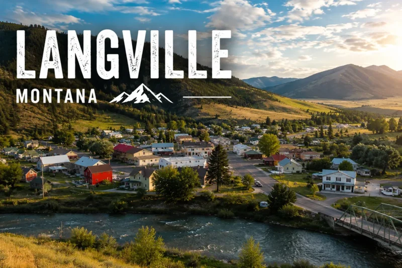
I was driving north out of Jordan one September afternoon when I realized I hadn’t seen another car in 42 minutes. The pavement ahead just kept going — flat to the horizon, then over the curve, then on.
A pronghorn ran parallel to me for half a mile and then peeled off into the badlands like it was bored. The radio had stopped working sometime back in Garfield County. The phone had no signal. It was the most alone I’d ever been on a paved American road, and it was perfect.
That’s Missouri River Country in a sentence: the part of Montana where the rest of the country forgets to come.
TL;DR
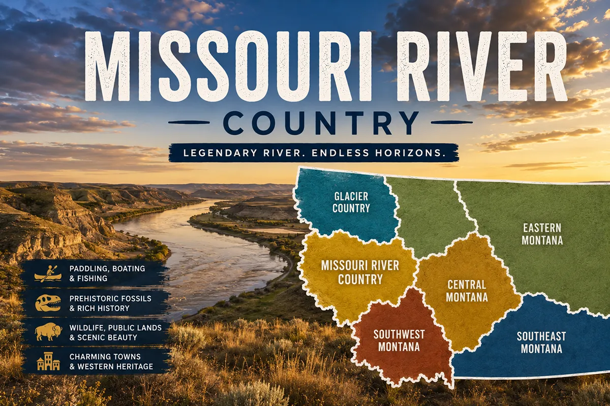
Missouri River Country is the northeast quadrant of Montana — the most remote, least visited, and most genuinely empty of the state’s six tourism regions. It’s anchored by Fort Peck Lake (the fifth-largest reservoir in the U.S. by volume), the Charles M. Russell National Wildlife Refuge (over 1.1 million acres), the Hell Creek Formation (the most important T. rex fossil bed on Earth), and the Hi-Line towns of Glasgow, Wolf Point, Malta, Sidney, Plentywood, and Scobey. Best time: late May through September, with September and early October as the connoisseur’s pick. This is not a first-time Montana destination. It’s where you come once you’ve seen the rest. And it’s where you come if you want to see the Northern Lights, find dinosaur fossils on a guided dig, or simply be somewhere where the sky still feels bigger than the ground.
What Is Missouri River Country?
Missouri River Country is one of Montana’s six official tourism regions, established by the Montana Legislature in 1986–87 along with the state lodging tax. It’s the northeast quadrant of Montana, covering 11 counties: Daniels, Dawson, Garfield, McCone, Petroleum (partial), Phillips, Prairie, Richland, Roosevelt, Sheridan, and Valley. [Verify exact county composition with current Visit Montana tourism region map before publishing.]
The region runs from the Saskatchewan border in the north to the Yellowstone River in the south, and from the North Dakota border in the east westward to the CMR Wildlife Refuge boundary.
It’s roughly the size of South Carolina. Total population is somewhere around 35,000 people spread across that area, which works out to fewer than 2 people per square mile in some counties.
Geographically, the region is dominated by three features:
- The Missouri River, which slices the region in half east-to-west
- Fort Peck Lake, a 134-mile-long reservoir behind the Fort Peck Dam (built 1933–40 as one of FDR’s largest New Deal public works projects)
- The prairie, vast and unbroken in every direction, broken only by river breaks and badlands
This is the part of Montana with the fewest mountains, the smallest towns, and by far the lowest visitor count. Around 65,000–75,000 visitors per year stay overnight in the region — for comparison, that’s roughly what Glacier National Park sees in a typical summer week. [Verify visitor stats with current Missouri River Country tourism data before publishing.]
A note on naming: nobody outside the tourism industry really calls this “Missouri River Country.” Locals call it “Northeast Montana” or “the Hi-Line east of Havre” or, most commonly, just “out here.”
Why You’d Actually Come Here
Before I go further: be honest with yourself about whether this region is right for your trip.
You’d love this region if you want…
- Genuine solitude and a sense of being far from everything
- Some of the best dark-sky stargazing in the contiguous U.S.
- A real shot at seeing the Northern Lights without going to Alaska
- World-class dinosaur fossil hunting (the only place in the world where the public can join active T. rex digs)
- Massive lake-based fishing for walleye, northern pike, and paddlefish
- Authentic small-town Montana without the curated tourism polish
- Lewis & Clark history that’s barely changed in 220 years
- A region where the local diner counter is the cultural center
You’d be disappointed by this region if you want…
- National park crowds or amenities
- Resort towns or mountain skiing
- Easy day trips between famous landmarks
- Reliable cell service or fast restaurant turnover
- Diverse food scenes or boutique shopping
- Anything resembling a luxury experience
This is not a casual region. It rewards travelers who want the trip itself to be the point.
The Towns of Missouri River Country
Where you base shapes the trip. None of these towns are big. None of them are pretentious. Here’s the honest breakdown.
Glasgow
The unofficial capital. Glasgow is the largest town between Williston, ND and Havre, MT — and even so, it’s only about 3,200 residents. It sits on the BNSF Hi-Line at the junction of US-2 and Highway 24, which runs south to Fort Peck Dam.
The town has the most amenities you’ll find in the region: a few hotels, several restaurants, a brewery (Busted Knuckle Brewing), the Pioneer Museum, and a small commercial airport (Wokal Field, GGW).
In 2018 a Washington Post travel piece called Glasgow “the middle of nowhere” by data — measured as the U.S. town furthest from any metropolitan area of 75,000+. It’s a title locals are now quietly proud of.
Base in Glasgow if: You’re visiting Fort Peck Dam, you want the most amenities in the region, or you’re driving through on the Hi-Line.
Fort Peck
A New Deal company town. Fort Peck is tiny — about 200 residents — but it punches enormously above its weight. Built in the 1930s as the construction camp for Fort Peck Dam, the town today preserves dozens of original 1930s buildings.
The Fort Peck Theatre — built in 1934 to entertain dam workers — is a stunning 1,100-seat wooden opera house that still hosts a full summer season of Broadway musicals. In a town of 200. In the middle of the empty prairie. It’s one of the most surreal cultural experiences in Montana.
The Fort Peck Interpretive Center & Museum has full-scale dinosaur skeletons (including a T. rex named “Peck’s Rex”) and excellent exhibits on the dam construction.
Wolf Point
A working town and the cultural heart of the Fort Peck Indian Reservation. Wolf Point is on the BNSF Hi-Line and home to the Wolf Point Wild Horse Stampede every second weekend of July — billed as the “Granddaddy of Montana Rodeos” and dating to 1915. It’s one of the oldest continuously operating rodeos in the American West.
The Fort Peck Reservation is shared by the Assiniboine and Sioux Tribes (the official name is the Fort Peck Assiniboine & Sioux Tribes). The reservation covers more than 2 million acres and is one of the largest in Montana.
Visitors are welcome at most public events; the Wadopana Pow Wow in August is the longest-running traditional powwow in the country.
Base in Wolf Point if: Your visit aligns with the Stampede or Wadopana Pow Wow, or you’re interested in Native cultural heritage.
Sidney
The largest town in the region. Sidney has roughly 6,400 residents — boosted by the Bakken oil boom that started around 2008. It’s the easternmost town of any size in Montana, just 7 miles from the North Dakota border.
The MonDak Heritage Center is a surprisingly good museum about the region’s three-state cultural overlap (Montana, North Dakota, eastern South Dakota).
Base in Sidney if: You’re flying in via Sidney-Richland Regional Airport (SDY) or Williston, ND (XWA), or you’re heading to Theodore Roosevelt National Park in North Dakota.
Malta
A small Hi-Line town with outsized paleontological credentials. Malta sits in a wide valley along the Milk River and is home to the Great Plains Dinosaur Museum & Field Station — one of the most active dinosaur research and public dig facilities in the world.
The famous mummified hadrosaur “Leonardo” was discovered just outside Malta. Bowdoin National Wildlife Refuge is 7 miles east — one of the best birding spots in the state.
Base in Malta if: Dinosaurs are your priority, or you’re doing the CMR Wildlife Refuge from the north.
Plentywood
The northeastern corner. Plentywood is the seat of Sheridan County and sits practically on the Saskatchewan border. The Sheridan County Museum has a surprising collection.
The town’s name (according to local lore) came from frontier sheriff Dutch Henry, who told a wagon train running out of firewood: “If you go down to the trees, you’ll find plenty wood.”
Base in Plentywood if: You’re crossing into Saskatchewan, or visiting Medicine Lake NWR.
Scobey
A wheat town near the Canadian border. Scobey is best known for the Pioneer Town Museum — a recreated frontier town with 35+ relocated original buildings. Visit during Pioneer Days the last weekend of June for living-history demonstrations.
Other Towns Worth Knowing
- Poplar — Fort Peck Reservation headquarters; the Fort Peck Tribes Museum is excellent
- Culbertson — small but with a remarkable agricultural museum
- Medicine Lake — gateway to the Medicine Lake NWR (see wildlife section)
- Froid and Flaxville — tiny grain elevator towns
- Fairview — the “Lift Bridge City,” straddling the Montana-North Dakota line
- Richey and Westby — far-northeast corners
- Circle — the McCone County seat, a quintessential ranch-country town
- Jordan — the Garfield County seat, the gateway to the Hell Creek Formation and the most famous fossil town in the world
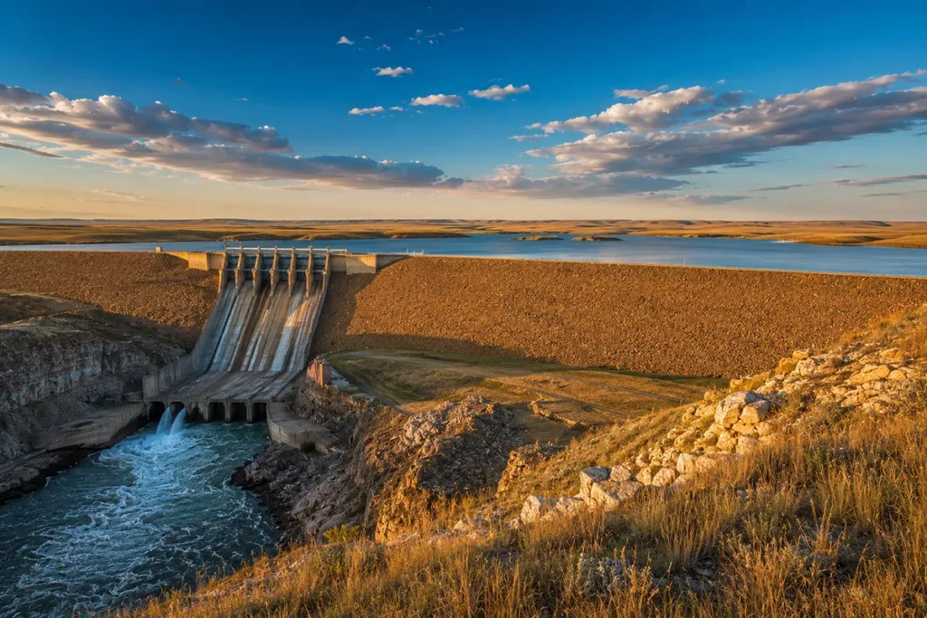
Fort Peck Dam and Fort Peck Lake
The defining man-made feature of the region. The Fort Peck Dam is a 21,000-foot-long earthen dam on the Missouri River, completed in 1940. At the time it was built, it was the largest hydraulically-filled earth-filled dam in the world — and it still ranks among the largest.
The construction project employed up to 10,500 workers during the Great Depression, and Margaret Bourke-White’s iconic 1936 photograph of the spillway was on the cover of the very first issue of LIFE Magazine.
The reservoir behind the dam — Fort Peck Lake — is 134 miles long with 1,520 miles of shoreline (more than the entire California coast). It holds 18.7 million acre-feet of water and is the fifth-largest reservoir in the United States by volume.
What you can actually do here:
- Fishing — walleye, northern pike, lake trout, smallmouth bass, and paddlefish (one of the few legal paddlefish fisheries in the world)
- Boating — multiple marinas; the lake is so big it has weather of its own
- Camping — Hell Creek State Park, Fort Peck Recreation Area, and dozens of dispersed sites
- Tour the Fort Peck Powerhouse — free guided tours in summer
- Fort Peck Interpretive Center — dinosaurs and dam history under one roof
- Fort Peck Theatre — summer Broadway musical season
The catch: the lake is shockingly remote in many sections. Cell service is nonexistent. If your boat breaks down, you might be a 6-hour rescue away. Take it seriously.
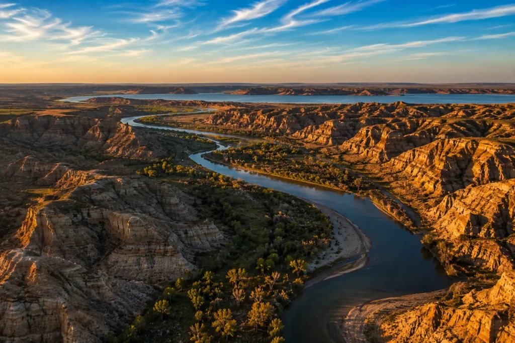
The Charles M. Russell National Wildlife Refuge
The CMR National Wildlife Refuge is the second-largest wildlife refuge in the lower 48 states, covering 1.1 million acres along 125 miles of the Missouri River and the entire CMR-managed length of Fort Peck Lake’s southern shoreline. It was established in 1936 and named for Montana cowboy artist Charles M. Russell.
This refuge is the closest thing the United States has to a “Serengeti experience” outside of Yellowstone. Wildlife you’ll regularly see:
- Elk — one of the largest herds in the state
- Bighorn sheep — Missouri Breaks population, reintroduced and thriving
- Mule deer — abundant
- Pronghorn — everywhere
- Coyotes, prairie dogs, ferrets (black-footed ferrets reintroduced in the refuge)
- Bald and golden eagles
- Occasional bison along the boundary with the American Prairie Reserve
The CMR Auto Tour Route is a 20-mile gravel drive accessible from US-191 south of Malta, offering a self-guided wildlife tour. Plan a full day; bring binoculars; carry water and a spare tire.
➡️ Full list: Montana wildlife refuges | American Prairie Reserve | Bird species
Hell Creek Formation: The Most Important Dinosaur Site on Earth
This is the headline that should be on every Missouri River Country travel guide and somehow isn’t.
The Hell Creek Formation is a 67-million-year-old rock layer exposed across eastern Montana, eastern Wyoming, and the western Dakotas.
It captures the final 2 million years of the Cretaceous Period — right up to the asteroid impact that ended the age of dinosaurs. The exposures around Jordan, Glasgow, and the CMR Wildlife Refuge are some of the richest and most accessible anywhere on Earth.
Some of the major discoveries from this formation:
- The first Tyrannosaurus rex — discovered by Barnum Brown in 1902 near Jordan
- Sue, MOR 555, Stan, and many other named T. rex specimens — all came out of Hell Creek
- Triceratops, Edmontosaurus, Ankylosaurus, Pachycephalosaurus — the entire “Last Day of the Dinosaurs” fauna
What you can actually do as a visitor:
- Visit the Great Plains Dinosaur Museum in Malta — public exhibits and active prep windows
- Visit the Fort Peck Interpretive Center in Fort Peck — full-scale T. rex casts
- Visit the Garfield County Museum in Jordan — small but legitimate
- Join a public fossil dig — operators like PaleoWorld Research Foundation, Judith River Dinosaur Institute, and others run multi-day public digs where you can actually excavate dinosaur bones alongside paleontologists. Costs vary; book months ahead. [Verify current operators before publishing.]
- Hike the badlands of the CMR refuge — you cannot collect fossils on federal land (this is a serious felony) but you can absolutely see them weathering out of the cliffs.
If you have any interest in paleontology, this is the trip.
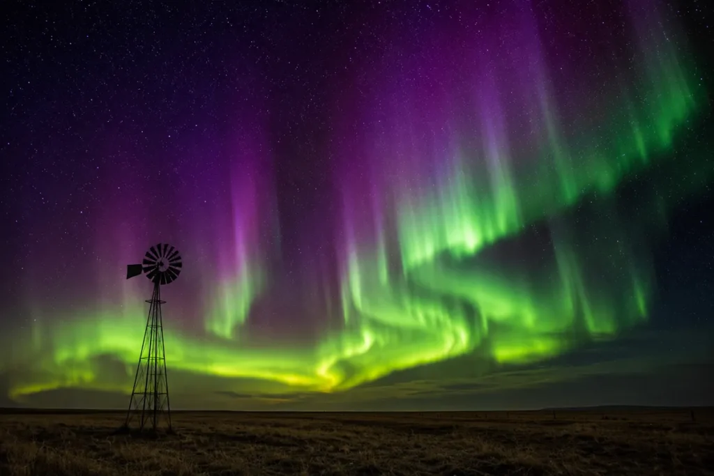
Northern Lights: Yes, You Can See Them Here
Missouri River Country is one of the best places in the contiguous United States to see the aurora borealis. The combination of high latitude (parts of the region sit at 48.9°N — further north than Vancouver), almost zero light pollution, and big-sky horizon visibility makes it ideal. During active geomagnetic storms, the aurora regularly appears overhead, not just on the horizon.
- Best months: September through March
- Best dark-sky locations: UL Bend National Wildlife Refuge, the Missouri Breaks, anywhere off the Hi-Line at least 20 miles from any town
- Best apps: “My Aurora Forecast Pro” — set alerts for KP index of 4+ when you’re in the region
➡️ Full guide: Does Montana see the Northern Lights? | Montana night sky
Hot Springs in Missouri River Country
Only one developed hot spring serves the region:
- Sleeping Buffalo Hot Springs — Saco, between Glasgow and Malta. The resort dates to the 1920s, was a New Deal-era destination, and reopened after major renovations in 2014. Two pools — one warm (~80°F) for swimming, one hot (~108°F) for soaking. They also operate a small airstrip — Montana ranchers literally fly in for a soak. One of the only hot springs in this part of the country.
➡️ Statewide picture: Montana hot springs
Other Wildlife Refuges Worth Knowing
Beyond the CMR, Missouri River Country has some of the best birding in North America:
- Medicine Lake National Wildlife Refuge — 31,700 acres, world-class waterfowl, sandhill cranes, white pelicans
- Bowdoin National Wildlife Refuge — east of Malta, exceptional for spring and fall migrations
- UL Bend National Wildlife Refuge — wrapped inside CMR, accessible by long gravel drive only, extraordinary solitude
➡️ Full list: Montana wildlife refuges
Fort Union Trading Post (Just Across the Line)
Technically in North Dakota, but accessed from Sidney and a must-visit. Fort Union Trading Post National Historic Site is a reconstructed 1828 fur trading post on the Missouri River.
It was the most important Upper Missouri fur trading post for 39 years and was visited by Audubon, Catlin, Karl Bodmer, and Sitting Bull. The reconstruction is meticulous. Free admission. About 25 minutes from Sidney.
A 5-Day Missouri River Country Itinerary
What I’d recommend for a first visit:
- Day 1: Fly into Williston (XWA) or Sidney (SDY). Drive to Glasgow. Settle in. Sunset on Fort Peck Lake.
- Day 2: Fort Peck Dam tour, Fort Peck Interpretive Center, Fort Peck Theatre evening performance (if in season).
- Day 3: CMR Auto Tour Route from the south side. Wildlife watching. Overnight in Lewistown (technically Central Montana) or back to Glasgow.
- Day 4: Jordan. Garfield County Museum. If you’ve pre-booked, a half-day at a public dinosaur dig.
- Day 5: Drive northeast. Lunch in Wolf Point. Wadopana Pow Wow grounds (if in August). Sleeping Buffalo Hot Springs soak. Aurora viewing if forecast supports.
For a longer trip: add Medicine Lake NWR, Plentywood/Scobey for the northern reach, and Fort Union Trading Post from Sidney.
Practical Info Box: Missouri River Country at a Glance
| Item | Details |
|---|---|
| Major airports | Williston Basin International (XWA, North Dakota); Sidney-Richland Regional (SDY); Glasgow Wokal Field (GGW); commercial options limited |
| Best season overall | Late May through September |
| Best aurora months | September through March |
| Best wildlife months | May–June, September |
| Counties included | 11 (verify with Visit Montana) |
| Major rivers | Missouri, Milk, Yellowstone |
| Largest reservoir | Fort Peck Lake (134 miles long, 1,520 miles of shoreline) |
| Largest wildlife refuge | CMR National Wildlife Refuge (1.1 million acres) |
| Bear country? | Limited; some grizzlies along the southern Missouri Breaks; mostly black bear country |
| Cell service | Genuinely spotty; nonexistent in CMR refuge and large stretches of US-2 |
| Time zone | Mountain Time (MST/MDT) |
➡️ See Montana airports for full options | Cell coverage in Montana
What I Wish I’d Known Before My First Trip
A few things that would have saved me real time, money, and one mild panic.
Gas stations are 60–90 miles apart in some stretches. This isn’t a joke. Tank up every chance you get. Always. The stretch from Jordan to Glasgow on Highway 24 has essentially one gas option in 130 miles.
Cell service is the worst in Montana. Verizon performs best in this region. AT&T struggles outside the larger towns. T-Mobile is essentially gone outside Glasgow and Sidney. Download every map you’ll need offline before you leave the Hi-Line.
Don’t trust GPS for backroads. Many “roads” on Google Maps are seasonal two-tracks. After rain, the gumbo (clay soil) turns to literal cement that will trap your rental car. Stick to numbered highways unless you have a high-clearance vehicle and know what you’re doing.
Bring water and snacks always. Many towns don’t have a convenience store open after 8pm. Some don’t have one at all.
Lodging is limited and books up around major events. The Wild Horse Stampede in mid-July fills every hotel within 50 miles of Wolf Point. Same for the Governor’s Cup walleye tournament in early July. Book well ahead if your visit aligns with either.
Diner culture is the social fabric. Local cafes in Glasgow, Malta, Jordan, and Wolf Point are where you’ll meet people, hear stories, and figure out what’s actually happening. Order whatever the daily special is. Tip 20%.
Mosquitos in June and July can be apocalyptic near Fort Peck Lake and the wildlife refuges. Bring real DEET, not the citronella stuff.
Wildlife on roads at dusk is constant. Especially mule deer. The deer-strike rate per capita in eastern Montana is among the highest in the country. Slow down at dawn and dusk.
The Hi-Line is windy. US-2 across this region routinely sees 30+ mph sustained winds. High-profile vehicles (RVs especially) need to know this. Truck drivers will warn you at any diner.
This region is way cheaper than the rest of Montana. A hotel night in Glasgow in July runs less than a single drink at a Bozeman bar. There’s a real value travel story here that nobody talks about.
➡️ More: How to visit Montana on a budget | Montana travel tips | Bear safety | Montana rattlesnakes
Where to Stay (Quick Reference)
| Stay style | Best location |
|---|---|
| Most amenities | Glasgow |
| Historic / quirky | Fort Peck (close to the dam, the theatre) |
| Reservation cultural | Wolf Point, Poplar |
| Oil-boom town comfort | Sidney |
| Hot springs resort | Saco (Sleeping Buffalo) |
| Ranch experience | Throughout — Phillips, Garfield, Valley counties |
| Off-grid camping | CMR Refuge dispersed sites, Hell Creek State Park |
How Missouri River Country Compares to the Other Five Regions
| Factor | Missouri River Country | Central Montana | Glacier Country | Yellowstone Country |
|---|---|---|---|---|
| Major national park | None | None | Glacier | Yellowstone |
| Headline feature | Fort Peck Lake + Hell Creek dinosaurs | Rocky Mountain Front | Glacier peaks | Yellowstone Plateau |
| Crowds | Lowest in the state | Very low | Heavy | Heavy |
| Best for | Off-grid adventure, fossils, aurora | Second-trip Montana | First-timers | First-timers |
| Affordability | Cheapest in the state | Affordable | Most expensive | Expensive |
| Cell service | Worst in the state | Patchy | Generally good | Generally good |
| Best season | Late May–Sept | May–Sept | Mid-July–mid-Sept | May–Sept |
| Native cultural heritage | Strong (Fort Peck Reservation) | Strong (Blackfeet, Rocky Boy) | Strong (CSKT, Blackfeet) | Limited |
➡️ Sister guides: Glacier Country | Yellowstone Country | Southwest Montana | Central Montana
Should You Visit Missouri River Country?
If you’ve never been to Montana — no, not yet. Start with Glacier Country or Yellowstone Country. Build up to this.
But if you’ve already done the famous parts, or if you came to Montana specifically because you wanted to be somewhere that hasn’t been remade for tourism, this is the place. Missouri River Country isn’t trying to be anything other than what it is.
It’s not pretty in the postcard way. It’s beautiful in a way that has to grow on you. It’s the kind of beauty that demands you sit on a hood of a car at dusk and let it wash over you slowly until you realize, somewhere in the second beer, that you can actually hear the curve of the earth.
I’ve been a lot of places in Montana. This is the region I come back to alone.
Save this guide for your trip planning or pin it for later. Got a specific question about Missouri River Country? Drop it in the comments — I read and answer every one. And when you’re ready for the sixth and final region, Southeast Montana (still called Custer Country by locals) is up next — Little Bighorn, badlands, the most authentic working ranch country in the state, and the Bucking Horse Sale every May.
➡️ Back to the main Montana Regions guide
Written by Sarah Bennett. The diner in Jordan still has the best coffee in northeast Montana, and yes, that pronghorn really did peel off because it got bored.